Downtown neighborhood in Atlanta, Georgia (GA), 30303, 30308, 30313 detailed profile
Settings
X


Business Search - 14 Million verified businesses
Area: 1.641 square miles
Population: 3,821
Population density:
| Downtown: | 2,329 people per square mile |
| Atlanta: | 3,788 people per square mile |

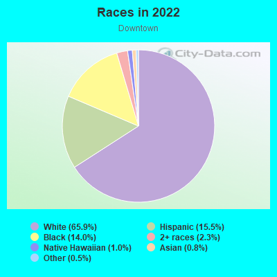
- 2,42761.8%Black
- 66817.0%White
- 49612.6%Asian
- 1253.2%Hispanic or Latino
- 842.1%Two or more races
- 792.0%Some other race
- 471.2%American Indian
Distribution of median household income
![Distribution of median household income]()
- 457Less than $10,000
- 340$10,000 to $19,999
- 71$20,000 to $29,999
- 190$30,000 to $39,999
- 412$40,000 to $49,999
- 135$50,000 to $59,999
- 122$60,000 to $74,999
- 226$75,000 to $99,999
- 272$100,000 to $124,999
- 136$125,000 to $149,999
- 467$150,000 to $199,999
- 493$200,000 or more

Distribution of owner-occupied house/condo value
![Distribution of owner-occupied house/condo value]()
- 420Less than $50,000
- 59$50,000 to $99,999
- 30$100,000 to $149,999
- 98$200,000 to $249,999
- 260$250,000 to $299,999
- 184$300,000 to $399,999
- 207$400,000 to $499,999
- 197$500,000 to $749,999
- 126$750,000 to $999,999
- 56$1,000,000 or more

Distribution of rent paid by renters
![Distribution of rent paid by renters]()
- 117Less than $100
- 928$100 to $199
- 87$200 to $299
- 133$300 to $399
- 24$400 to $499
- 432$500 to $599
- 194$600 to $699
- 137$700 to $799
- 46$800 to $899
- 310$900 to $999
- 401$1,000 to $1,249
- 778$1,250 to $1,499
- 669$1,500 to $1,999
- 226$2,000 or more

Median rent in 2022:
| Downtown: | $1,364 |
| Atlanta: | $1,477 |
| Males: | 2,054 |
| Females: | 1,766 |
Males:
| This neighborhood: | 34.6 years |
| Whole city: | 33.7 years |
| This neighborhood: | 38.3 years |
| Whole city: | 34.3 years |
Average household size:
| Downtown: | 1.7 people |
| Atlanta: | 2.0 people |
Percentage of family households:
| Downtown: | 15.7% |
| Atlanta: | 31.6% |
| Here: | 7.0% |
| Atlanta: | 24.9% |
Percentage of married-couple families with children (among all households):
| Downtown: | 16.5% |
| Atlanta: | 23.2% |
Percentage of single-mother households (among all households):
| Downtown: | 65.3% |
| Atlanta: | 22.0% |
Percentage of never married males 15 years old and over:
Percentage of never married females 15 years old and over:
| Downtown: | 40.4% |
| Atlanta: | 28.0% |
Percentage of never married females 15 years old and over:
| Downtown: | 38.0% |
| city: | 26.3% |
Percentage of people that speak English not well or not at all:
| Downtown: | 0.0% |
| Atlanta: | 1.0% |
Percentage of people born in this state:
Percentage of people born in another U.S. state:
Percentage of native residents but born outside the U.S.:
Percentage of foreign born residents:
| Here: | 32.3% |
| Atlanta: | 46.3% |
Percentage of people born in another U.S. state:
| Downtown: | 54.6% |
| Atlanta: | 43.2% |
Percentage of native residents but born outside the U.S.:
| Here: | 4.9% |
| city: | 2.0% |
Percentage of foreign born residents:
| Here: | 8.2% |
| Atlanta: | 8.5% |
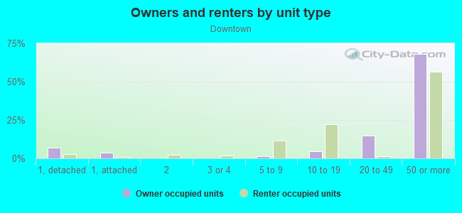
Owner-occupied
Renter-occupied

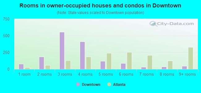
- Rooms in owner-occupied houses and condos in Downtown
- 791 room
- 1852 rooms
- 5563 rooms
- 4134 rooms
- 1215 rooms
- 906 rooms
- 337 rooms
- 378 rooms
- 479+ rooms
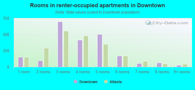
- Rooms in renter-occupied apartments in Downtown
- 1541 room
- 952 rooms
- 6993 rooms
- 4154 rooms
- 5035 rooms
- 1736 rooms
- 547 rooms
- 658 rooms
- 299+ rooms
Owner-occupied
Renter-occupied
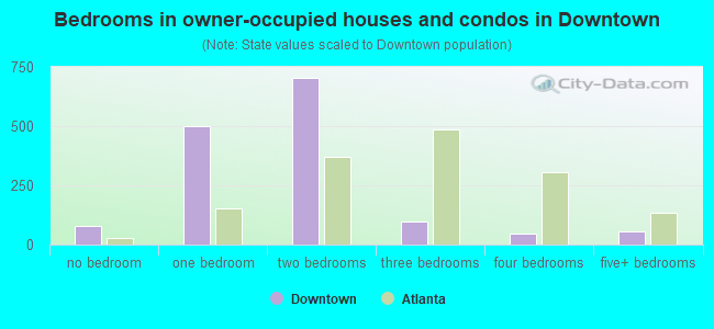
- Bedrooms in owner-occupied houses and condos in Downtown
- 79no bedroom
- 4981 bedroom
- 7042 bedrooms
- 983 bedrooms
- 474 bedrooms
- 565+ bedrooms
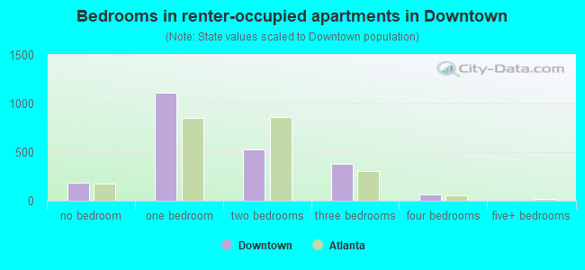
- Bedrooms in renter-occupied apartments in Downtown
- 188no bedroom
- 1,1121 bedroom
- 5292 bedrooms
- 3823 bedrooms
- 664 bedrooms
- 05+ bedrooms
Average number of cars or other vehicles available in houses/condos:
Average number of cars or other vehicles available in apartments:
| This neighborhood: | |
| Atlanta: |
Average number of cars or other vehicles available in apartments:
| Here: | 0.6 |
| city: | 1.0 |
Percentage of units with a mortgage:
| Downtown: | 59.1% |
| Atlanta: | 72.0% |
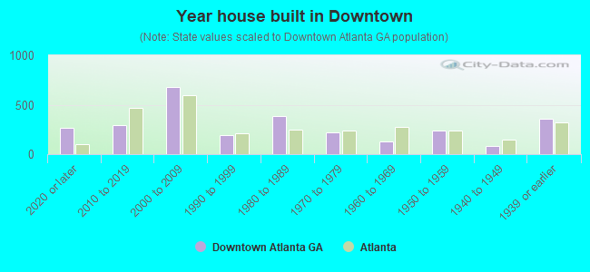
- Year house built in Downtown
- 2682020 or later
- 2972010 to 2019
- 6792000 to 2009
- 1891990 to 1999
- 3821980 to 1989
- 2181970 to 1979
- 1311960 to 1969
- 2361950 to 1959
- 801940 to 1949
- 3581939 or earlier
City-data.com crime index for city in 2020 (higher means more crime):
| City: | 140.2 |
| U.S. average: | 219.5 |
Travel time to work (commute)
![Travel time to work (commute)]()
- 30Less than 5 minutes
- 1615 to 9 minutes
- 31210 to 14 minutes
- 72715 to 19 minutes
- 30620 to 24 minutes
- 13825 to 29 minutes
- 11930 to 34 minutes
- 9435 to 39 minutes
- 31840 to 44 minutes
- 14745 to 59 minutes
- 10960 to 89 minutes
- 9690 or more minutes

Means of transportation to work
![Means of transportation to work]()
- 40.5%995Drove a car alone
- 11.0%271Carpooled
- 18.4%453Bus
- 5.1%125Subway or elevated rail
- 30.0%736Taxi
- 4.3%105Bicycle
- 10.7%264Walked
- 7.0%171Other means
- 18.6%458Worked at home

Time leaving home to go to work
![Time leaving home to go to work]()
- 5312:00 a.m. to 4:59 a.m.
- 2755:00 a.m. to 5:29 a.m.
- 625:30 a.m. to 5:59 a.m.
- 1686:00 a.m. to 6:29 a.m.
- 1606:30 a.m. to 6:59 a.m.
- 1607:00 a.m. to 7:29 a.m.
- 2407:30 a.m. to 7:59 a.m.
- 2748:00 a.m. to 8:29 a.m.
- 4288:30 a.m. to 8:59 a.m.
- 2809:00 a.m. to 9:59 a.m.
- 2810:00 a.m. to 10:59 a.m.
- 7811:00 a.m. to 11:59 a.m.
- 9112:00 p.m. to 3:59 p.m.
- 2714:00 p.m. to 11:59 p.m.

Occupations of males:
- Percentage of males in management occupations (except farmers):
Here: 5.5% city: 16.5%
- Percentage of males in business and financial operations occupations:
Here: 10.4% city: 10.8%
- Percentage of males in computer and mathematical occupations:
Here: 14.2% city: 8.5%
- Percentage of males in architecture and engineering occupations:
Here: 4.8% city: 4.2%
- Percentage of males in life, physical, and social science occupations:
Here: 2.1% city: 1.8%
- Percentage of males in community and social services occupations:
Here: 3.0% city: 0.8%
- Percentage of males in legal occupations:
Here: 1.2% city: 3.3%
- Percentage of males in education, training, and library occupations:
Here: 3.4% city: 5.1%
- Percentage of males in arts, design, entertainment, sports, and media occupations:
Here: 5.2% city: 4.8%
- Percentage of males in healthcare practitioners and technical occupations:
Here: 7.4% city: 3.4%
- Percentage of males in service occupations:
Here: 8.5% city: 11.5%
- Percentage of males in sales and office occupations:
Here: 17.3% city: 15.1%
- Percentage of males in production occupations:
Here: 2.1% city: 1.9%
- Percentage of males in transportation occupations:
Here: 10.9% city: 4.0%
- Percentage of males in material moving occupations:
Here: 1.6% city: 4.3%
Occupations of females:
- Percentage of females in management occupations (except farmers):
Here: 9.8% city: 14.0%
- Percentage of females in business and financial operations occupations:
Here: 3.2% city: 10.8%
- Percentage of females in computer and mathematical occupations:
Here: 31.0% city: 3.2%
- Percentage of females in education, training, and library occupations:
Here: 7.6% city: 8.9%
- Percentage of females in arts, design, entertainment, sports, and media occupations:
Here: 2.2% city: 4.9%
- Percentage of females in service occupations:
Here: 25.1% city: 13.9%
- Percentage of females in sales and office occupations:
Here: 18.8% city: 21.9%
- Percentage of females in production occupations:
Here: 1.6% city: 1.9%
Percentage of people 16-64 in Armed Forces:
| Downtown: | 1.8% |
| Atlanta: | 0.2% |
Education in this neighborhood (subdivision or community):
- Percentage of people 3 years and older in K-12 schools:
Downtown: 113.3% Atlanta: 12.5%
- Percentage of people 3 years and older in undergraduate colleges:
Downtown: 19.9% Atlanta: 8.9%
- Percentage of people 3 years and older in grad. or professional schools:
Downtown: 20.9% Atlanta: 3.3%
- Percentage of students K-12 enrolled in private schools:
Downtown: 0.3% Atlanta: 22.5%
Percentage of population below poverty level:
| Downtown: | 38.4% |
| Atlanta: | 17.3% |
Median year renter moved in (as recorded in 2022):
| Downtown: | 2018 |
| Atlanta: | 2020 |
Percentage of married-couple families with both working:
| Downtown: | 245.7% |
| Atlanta: | 79.0% |
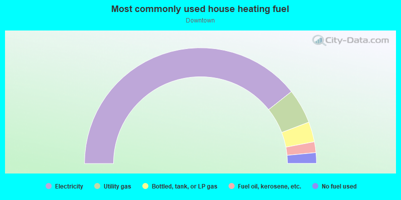
- 78.6%Electricity
- 9.7%Utility gas
- 5.6%Bottled, tank, or LP gas
- 3.0%Fuel oil, kerosene, etc.
- 3.0%No fuel used
Limited-access highways (interstate or state) in this neighborhood:
State Rte 401 (I- 85, I- 75, State Rte 403)
Length: 3.50 miles
Directions: E-W, N-S, SE-NW, SW-NE
Directions: E-W, N-S, SE-NW, SW-NE
I- 20 (State Rte 402)
Length: 0.84 miles
Direction: E-W
Direction: E-W
Highways in this neighborhood:
State Rte 154 (Trinity Ave SW, State Rte 14)
Length: 0.64 miles
Directions: E-W, N-S, SE-NW
Address range: 30 to 299
Directions: E-W, N-S, SE-NW
Address range: 30 to 299
State Rte 14 (Memorial Dr SE, State Rte 154)
Length: 0.07 miles
Direction: E-W
Address range: 12 to 36
Direction: E-W
Address range: 12 to 36
Roads and streets:
Spring St NW
Length: 1.26 miles
Directions: N-S, SW-NE
Address range: 30 to 282
Directions: N-S, SW-NE
Address range: 30 to 282
Peachtree St (Peachtree St NW)
Length: 1.17 miles
Directions: E-W, N-S, SW-NE
Address range: 1 to 559
Directions: E-W, N-S, SW-NE
Address range: 1 to 559
Courtland St NE
Length: 1.08 miles
Direction: N-S
Address range: 1 to 599
Direction: N-S
Address range: 1 to 599
Piedmont Ave NE
Length: 1.08 miles
Direction: N-S
Address range: 1 to 2205
Direction: N-S
Address range: 1 to 2205
Peachtree Center Ave NE
Length: 0.81 miles
Directions: N-S, SW-NE
Address range: 1 to 399
Directions: N-S, SW-NE
Address range: 1 to 399
Pryor Rd
Length: 0.80 miles
Directions: N-S, SW-NE
Address range: 1 to 341
Directions: N-S, SW-NE
Address range: 1 to 341
International Blvd
Length: 0.79 miles
Directions: E-W, SW-NE
Address range: 1 to 319
Directions: E-W, SW-NE
Address range: 1 to 319
Techwood Dr NW
Length: 0.78 miles
Directions: E-W, N-S, SW-NE
Address range: 1 to 281
Directions: E-W, N-S, SW-NE
Address range: 1 to 281
Edgewood Ave NE (Edgewood Ave SE)
Length: 0.78 miles
Directions: E-W, SE-NW
Address range: 58 to 743
Directions: E-W, SE-NW
Address range: 58 to 743
Auburn Ave NE
Length: 0.72 miles
Directions: E-W, SE-NW
Address range: 1 to 299
Directions: E-W, SE-NW
Address range: 1 to 299
Martin Luther King Jr Dr SW
Length: 0.71 miles
Directions: E-W, SE-NW
Address range: 1 to 455
Directions: E-W, SE-NW
Address range: 1 to 455
Central Ave SW
Length: 0.71 miles
Directions: E-W, N-S, SW-NE
Address range: 1 to 387
Directions: E-W, N-S, SW-NE
Address range: 1 to 387
Marietta St
Length: 0.70 miles
Direction: SE-NW
Address range: 1 to 338
Direction: SE-NW
Address range: 1 to 338
Mitchell St SW
Length: 0.68 miles
Direction: SE-NW
Address range: 1 to 327
Direction: SE-NW
Address range: 1 to 327
Luckie St NW
Length: 0.66 miles
Directions: E-W, SE-NW
Address range: 2 to 299
Directions: E-W, SE-NW
Address range: 2 to 299
John Wesley Dobbs Ave NE
Length: 0.66 miles
Direction: E-W
Address range: 4 to 407
Direction: E-W
Address range: 4 to 407
Whitehall St SW (Peachtree St SW)
Length: 0.62 miles
Direction: SW-NE
Address range: 1 to 299
Direction: SW-NE
Address range: 1 to 299
Forsyth St SW
Length: 0.62 miles
Directions: N-S, SE-NW, SW-NE
Address range: 1 to 299
Directions: N-S, SE-NW, SW-NE
Address range: 1 to 299
Decatur St SE
Length: 0.62 miles
Directions: E-W, SE-NW
Address range: 1 to 276
Directions: E-W, SE-NW
Address range: 1 to 276
Williams St NW
Length: 0.61 miles
Directions: N-S, SE-NW, SW-NE
Address range: 1 to 367
Directions: N-S, SE-NW, SW-NE
Address range: 1 to 367
Elliott St NW
Length: 0.58 miles
Directions: E-W, N-S, SE-NW, SW-NE
Address range: 1 to 229
Directions: E-W, N-S, SE-NW, SW-NE
Address range: 1 to 229
Haynes St NW
Length: 0.57 miles
Direction: N-S
Address range: 1 to 299
Direction: N-S
Address range: 1 to 299
Butler St SE
Length: 0.57 miles
Direction: SW-NE
Address range: 1 to 299
Direction: SW-NE
Address range: 1 to 299
Washington St SW
Length: 0.57 miles
Direction: SW-NE
Address range: 2 to 316
Direction: SW-NE
Address range: 2 to 316
Mangum St NW
Length: 0.57 miles
Directions: E-W, N-S, SE-NW
Address range: 1 to 299
Directions: E-W, N-S, SE-NW
Address range: 1 to 299
Memorial Dr SW
Length: 0.56 miles
Directions: E-W, SW-NE
Address range: 31 to 299
Directions: E-W, SW-NE
Address range: 31 to 299
Walton St NW
Length: 0.55 miles
Direction: SE-NW
Address range: 1 to 299
Direction: SE-NW
Address range: 1 to 299
Baker St NW
Length: 0.52 miles
Direction: E-W
Address range: 1 to 299
Direction: E-W
Address range: 1 to 299
Piedmont Ave SE
Length: 0.49 miles
Direction: SW-NE
Address range: 1 to 299
Direction: SW-NE
Address range: 1 to 299
Martin Luther King Jr Dr SE
Length: 0.47 miles
Direction: SE-NW
Address range: 1 to 98
Direction: SE-NW
Address range: 1 to 98
Harris St NW
Length: 0.44 miles
Directions: E-W, SW-NE
Address range: 1 to 199
Directions: E-W, SW-NE
Address range: 1 to 199
Fairlie St NW
Length: 0.44 miles
Directions: N-S, SW-NE
Address range: 4 to 149
Directions: N-S, SW-NE
Address range: 4 to 149
Broad St SW
Length: 0.42 miles
Direction: SW-NE
Address range: 1 to 239
Direction: SW-NE
Address range: 1 to 239
Forsyth St NW
Length: 0.41 miles
Directions: E-W, SW-NE
Address range: 1 to 199
Directions: E-W, SW-NE
Address range: 1 to 199
Ellis St NE
Length: 0.41 miles
Direction: E-W
Address range: 3 to 273
Direction: E-W
Address range: 3 to 273
Baker St NE
Length: 0.41 miles
Direction: E-W
Address range: 3 to 161
Direction: E-W
Address range: 3 to 161
Gilmer St SE
Length: 0.40 miles
Directions: N-S, SE-NW
Address range: 1 to 133
Directions: N-S, SE-NW
Address range: 1 to 133
Garnett St SW
Length: 0.39 miles
Direction: SE-NW
Address range: 100 to 285
Direction: SE-NW
Address range: 100 to 285
Spring St SW
Length: 0.38 miles
Direction: SW-NE
Address range: 1 to 186
Direction: SW-NE
Address range: 1 to 186
Linden Ave NE
Length: 0.38 miles
Direction: E-W
Address range: 20 to 98
Direction: E-W
Address range: 20 to 98
Pine St NE
Length: 0.38 miles
Direction: E-W
Address range: 1 to 299
Direction: E-W
Address range: 1 to 299
Harris St NE
Length: 0.37 miles
Direction: E-W
Address range: 1 to 155
Direction: E-W
Address range: 1 to 155
International Blvd NE
Length: 0.37 miles
Direction: E-W
Address range: 3 to 299
Direction: E-W
Address range: 3 to 299
Alabama St SW
Length: 0.36 miles
Directions: E-W, SE-NW
Address range: 1 to 199
Directions: E-W, SE-NW
Address range: 1 to 199
W Peachtree St NE (W Peachtree St NW)
Length: 0.35 miles
Direction: N-S
Address range: 289 to 436
Direction: N-S
Address range: 289 to 436
Courtland St SE
Length: 0.32 miles
Direction: SW-NE
Address range: 1 to 199
Direction: SW-NE
Address range: 1 to 199
Pratt St SE
Length: 0.31 miles
Directions: E-W, SW-NE
Address range: 49 to 195
Directions: E-W, SW-NE
Address range: 49 to 195
Ralph McGill Blvd
Length: 0.29 miles
Directions: E-W, SW-NE
Address range: 1 to 160
Directions: E-W, SW-NE
Address range: 1 to 160
Butler St NE
Length: 0.27 miles
Directions: N-S, SE-NW
Address range: 1 to 203
Directions: N-S, SE-NW
Address range: 1 to 203
Cone St NW
Length: 0.27 miles
Direction: SW-NE
Address range: 1 to 199
Direction: SW-NE
Address range: 1 to 199
Broad St NW
Length: 0.27 miles
Direction: SW-NE
Address range: 1 to 99
Direction: SW-NE
Address range: 1 to 99
Alexander St NW
Length: 0.25 miles
Direction: E-W
Address range: 4 to 116
Direction: E-W
Address range: 4 to 116
Park Pl NE
Length: 0.25 miles
Directions: N-S, SW-NE
Address range: 1 to 61
Directions: N-S, SW-NE
Address range: 1 to 61
Currier St NE
Length: 0.25 miles
Directions: E-W, SE-NW
Address range: 1 to 199
Directions: E-W, SE-NW
Address range: 1 to 199
Ga Dome St NW
Length: 0.24 miles
Direction: E-W
Address range: 301 to 423
Direction: E-W
Address range: 301 to 423
Poplar St NW
Length: 0.23 miles
Direction: SE-NW
Address range: 1 to 199
Direction: SE-NW
Address range: 1 to 199
Renaissance Pkwy NE
Length: 0.23 miles
Direction: E-W
Address range: 1100 to 1122
Direction: E-W
Address range: 1100 to 1122
W Peachtree St NW
Length: 0.22 miles
Directions: N-S, SW-NE
Address range: 401 to 578
Directions: N-S, SW-NE
Address range: 401 to 578
Bell St NE
Length: 0.22 miles
Direction: N-S
Address range: 1 to 61
Direction: N-S
Address range: 1 to 61
Nelson St SW
Length: 0.21 miles
Directions: E-W, SE-NW
Address range: 200 to 295
Directions: E-W, SE-NW
Address range: 200 to 295
Simpson Rd NW (Simpson St NW)
Length: 0.21 miles
Direction: E-W
Address range: 1 to 89
Direction: E-W
Address range: 1 to 89
Scott St NW
Length: 0.21 miles
Direction: N-S
Address range: 346 to 419
Direction: N-S
Address range: 346 to 419
Linden Ave NW
Length: 0.20 miles
Direction: E-W
Address range: 1 to 99
Direction: E-W
Address range: 1 to 99
Capitol Ave SE
Length: 0.20 miles
Directions: N-S, SW-NE
Address range: 200 to 274
Directions: N-S, SW-NE
Address range: 200 to 274
Armstrong St SE
Length: 0.20 miles
Direction: SE-NW
Address range: 1 to 99
Direction: SE-NW
Address range: 1 to 99
Brotherton St SW
Length: 0.20 miles
Direction: SE-NW
Address range: 200 to 277
Direction: SE-NW
Address range: 200 to 277
W Peachtree Pl NW
Length: 0.20 miles
Direction: E-W
Address range: 3 to 87
Direction: E-W
Address range: 3 to 87
Margaret Mitchell Sq NW (Carnegie Way NW)
Length: 0.20 miles
Directions: N-S, SE-NW
Address range: 100 to 203
Directions: N-S, SE-NW
Address range: 100 to 203
Wall St NW
Length: 0.19 miles
Direction: SE-NW
Address range: 1 to 99
Direction: SE-NW
Address range: 1 to 99
Georgia Dome Dr NW
Length: 0.19 miles
Direction: E-W
Address range: 1 to 79
Direction: E-W
Address range: 1 to 79
Coca Cola Pl SE
Length: 0.18 miles
Directions: N-S, SE-NW
Address range: 1 to 99
Directions: N-S, SE-NW
Address range: 1 to 99
Parker St NW
Length: 0.17 miles
Direction: E-W
Address range: 1 to 77
Direction: E-W
Address range: 1 to 77
Hunnicutt St NW
Length: 0.17 miles
Directions: E-W, SW-NE
Address range: 1 to 100
Directions: E-W, SW-NE
Address range: 1 to 100
Terminal St NW
Length: 0.15 miles
Direction: N-S
Address range: 1 to 91
Direction: N-S
Address range: 1 to 91
Wall St SW (Wall St SE)
Length: 0.15 miles
Direction: SE-NW
Address range: 1 to 99
Direction: SE-NW
Address range: 1 to 99
Prescott St NE
Length: 0.15 miles
Direction: E-W
Address range: 3 to 99
Direction: E-W
Address range: 3 to 99
Bishop Aly NE
Length: 0.14 miles
Direction: E-W
Address range: 102 to 165
Direction: E-W
Address range: 102 to 165
Alexander St NE
Length: 0.14 miles
Directions: E-W, SW-NE
Address range: 1 to 37
Directions: E-W, SW-NE
Address range: 1 to 37
Foundry St NW
Length: 0.14 miles
Direction: SW-NE
Address range: 43 to 399
Direction: SW-NE
Address range: 43 to 399
Bell St SE
Length: 0.14 miles
Directions: N-S, SE-NW, SW-NE
Directions: N-S, SE-NW, SW-NE
Spring Techwood Con
Length: 0.13 miles
Directions: N-S, SW-NE
Directions: N-S, SW-NE
Spring W Peachtree Con
Length: 0.13 miles
Directions: E-W, N-S, SE-NW, SW-NE
Directions: E-W, N-S, SE-NW, SW-NE
Capitol Sq SW
Length: 0.13 miles
Direction: SE-NW
Address range: 1 to 51
Direction: SE-NW
Address range: 1 to 51
Hayden St NW
Length: 0.12 miles
Directions: N-S, SW-NE
Address range: 200 to 286
Directions: N-S, SW-NE
Address range: 200 to 286
Glazener Ave NE
Length: 0.12 miles
Direction: E-W
Address range: 100 to 159
Direction: E-W
Address range: 100 to 159
Produce Row SW
Length: 0.11 miles
Direction: SE-NW
Address range: 1 to 51
Direction: SE-NW
Address range: 1 to 51
Thurmond St NW
Length: 0.11 miles
Direction: SW-NE
Address range: 200 to 299
Direction: SW-NE
Address range: 200 to 299
Williams St
Length: 0.10 miles
Direction: E-W
Address range: 1 to 99
Direction: E-W
Address range: 1 to 99
Earle St NW
Length: 0.10 miles
Direction: SW-NE
Address range: 200 to 399
Direction: SW-NE
Address range: 200 to 399
Porter Pl NE
Length: 0.10 miles
Directions: E-W, SE-NW
Address range: 1 to 99
Directions: E-W, SE-NW
Address range: 1 to 99
Auditorium Pl SE
Length: 0.10 miles
Direction: SE-NW
Address range: 10 to 33
Direction: SE-NW
Address range: 10 to 33
Capitol Pl SW
Length: 0.10 miles
Direction: SW-NE
Address range: 200 to 269
Direction: SW-NE
Address range: 200 to 269
Formwalt St SW
Length: 0.10 miles
Directions: N-S, SE-NW
Directions: N-S, SE-NW
Mills St NW
Length: 0.09 miles
Direction: E-W
Address range: 1 to 100
Direction: E-W
Address range: 1 to 100
St Lukes Pl NE
Length: 0.09 miles
Direction: E-W
Address range: 64 to 99
Direction: E-W
Address range: 64 to 99
Ralph McGill Blvd (Forrest Ave NE)
Length: 0.09 miles
Direction: E-W
Address range: 56 to 83
Direction: E-W
Address range: 56 to 83
Nassau St NW
Length: 0.09 miles
Direction: SE-NW
Address range: 100 to 199
Direction: SE-NW
Address range: 100 to 199
Hurt Plz SE
Length: 0.09 miles
Directions: N-S, SE-NW
Address range: 1 to 99
Directions: N-S, SE-NW
Address range: 1 to 99
Peachtree St NE
Length: 0.09 miles
Direction: N-S
Address range: 1 to 299
Direction: N-S
Address range: 1 to 299
Winship Aly NW
Length: 0.09 miles
Direction: N-S
Address range: 192 to 235
Direction: N-S
Address range: 192 to 235
Boaz St SE
Length: 0.09 miles
Directions: E-W, SE-NW
Address range: 1 to 43
Directions: E-W, SE-NW
Address range: 1 to 43
Baltimore Pl NW
Length: 0.09 miles
Directions: E-W, N-S, SE-NW
Address range: 3 to 99
Directions: E-W, N-S, SE-NW
Address range: 3 to 99
Magnolia Pl NW
Length: 0.08 miles
Direction: N-S
Address range: 124 to 165
Direction: N-S
Address range: 124 to 165
Bishop St NE
Length: 0.08 miles
Direction: N-S
Address range: 482 to 515
Direction: N-S
Address range: 482 to 515
Grant Pl NE
Length: 0.08 miles
Direction: E-W
Address range: 1 to 99
Direction: E-W
Address range: 1 to 99
Equitable Pl NE
Length: 0.08 miles
Direction: N-S
Address range: 1 to 37
Direction: N-S
Address range: 1 to 37
Latimer St NW
Length: 0.07 miles
Direction: SW-NE
Address range: 200 to 399
Direction: SW-NE
Address range: 200 to 399
Ellis St NW
Length: 0.06 miles
Directions: E-W, SW-NE
Address range: 1 to 99
Directions: E-W, SW-NE
Address range: 1 to 99
Benton St NE
Length: 0.06 miles
Direction: N-S
Address range: 498 to 529
Direction: N-S
Address range: 498 to 529
Cooper St SW
Length: 0.06 miles
Directions: N-S, SE-NW
Address range: 274 to 347
Directions: N-S, SE-NW
Address range: 274 to 347
Kimball Way SE
Length: 0.06 miles
Direction: SW-NE
Address range: 1 to 43
Direction: SW-NE
Address range: 1 to 43
Falcon Way NW
Length: 0.06 miles
Direction: E-W
Direction: E-W
Lynchs Aly NE
Length: 0.06 miles
Direction: E-W
Address range: 70 to 129
Direction: E-W
Address range: 70 to 129
Mc Cord Pl SE
Length: 0.05 miles
Direction: SW-NE
Address range: 76 to 93
Direction: SW-NE
Address range: 76 to 93
Rhodes St NW
Length: 0.05 miles
Direction: E-W
Address range: 430 to 449
Direction: E-W
Address range: 430 to 449
Hunter St SW
Length: 0.05 miles
Directions: E-W, SE-NW
Directions: E-W, SE-NW
Spring Techwood Conn NW
Length: 0.04 miles
Direction: N-S
Direction: N-S
Hix Green Aly NE
Length: 0.04 miles
Direction: N-S
Address range: 558 to 609
Direction: N-S
Address range: 558 to 609
Collins St
Length: 0.04 miles
Direction: SW-NE
Direction: SW-NE
Clover Ln NE
Length: 0.04 miles
Direction: E-W
Address range: 120 to 165
Direction: E-W
Address range: 120 to 165
Hull St NW
Length: 0.04 miles
Directions: E-W, N-S, SW-NE
Address range: 200 to 296
Directions: E-W, N-S, SW-NE
Address range: 200 to 296
Pulliam St SW
Length: 0.04 miles
Directions: N-S, SE-NW
Address range: 262 to 323
Directions: N-S, SE-NW
Address range: 262 to 323
Pine St NW
Length: 0.03 miles
Direction: E-W
Address range: 1 to 16
Direction: E-W
Address range: 1 to 16
Banks Pl NE
Length: 0.03 miles
Direction: E-W
Address range: 1 to 41
Direction: E-W
Address range: 1 to 41
Journal Way NW
Length: 0.03 miles
Direction: E-W
Direction: E-W
Houston St NE
Length: 0.02 miles
Direction: E-W
Address range: 1 to 427
Direction: E-W
Address range: 1 to 427
Trinity Ave Conn SW
Length: 0.02 miles
Directions: N-S, SW-NE
Directions: N-S, SW-NE
Railroad features:
Metropolitan Atlanta Rapid Transit Authority
Length: 2.43 miles
Directions: E-W, N-S, SE-NW, SW-NE
Directions: E-W, N-S, SE-NW, SW-NE
Csx RR
Length: 2.42 miles
Directions: E-W, N-S, SE-NW, SW-NE
Directions: E-W, N-S, SE-NW, SW-NE
Csx Transportation
Length: 0.90 miles
Directions: E-W, N-S, SE-NW, SW-NE
Directions: E-W, N-S, SE-NW, SW-NE
Norfolk Southern Rlwy
Length: 0.64 miles
Directions: N-S, SE-NW
Directions: N-S, SE-NW