Del Obispo (Del Obispo Area) neighborhood in Dana Point, California (CA), 92624, 92629, 92675 detailed profile
Settings
X


Business Search - 14 Million verified businesses
Area: 1.726 square miles
Population: 4,415
Population density:
| Del Obispo (Del Obispo Area): | 2,559 people per square mile |
| Dana Point: | 4,976 people per square mile |

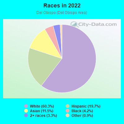
- 2,95460.3%White
- 96519.7%Hispanic or Latino
- 56611.5%Asian
- 2074.2%Black
- 1623.3%Two or more races
- 450.9%Some other race
- 30.06%Native Hawaiian and Other
Pacific Islander
Distribution of median household income
![Distribution of median household income]()
- 88Less than $10,000
- 344$10,000 to $19,999
- 450$20,000 to $29,999
- 128$30,000 to $39,999
- 89$40,000 to $49,999
- 84$50,000 to $59,999
- 235$60,000 to $74,999
- 106$75,000 to $99,999
- 261$100,000 to $124,999
- 251$125,000 to $149,999
- 200$150,000 to $199,999
- 943$200,000 or more

Distribution of owner-occupied house/condo value
![Distribution of owner-occupied house/condo value]()
- 11Less than $50,000
- 189$50,000 to $99,999
- 148$100,000 to $149,999
- 122$150,000 to $199,999
- 133$200,000 to $249,999
- 69$250,000 to $299,999
- 141$300,000 to $399,999
- 97$400,000 to $499,999
- 90$500,000 to $749,999
- 466$750,000 to $999,999
- 1,446$1,000,000 or more

Distribution of rent paid by renters
![Distribution of rent paid by renters]()
- 4$300 to $399
- 80$500 to $599
- 9$600 to $699
- 125$700 to $799
- 6$800 to $899
- 31$900 to $999
- 4$1,000 to $1,249
- 121$1,250 to $1,499
- 37$1,500 to $1,999
- 466$2,000 or more

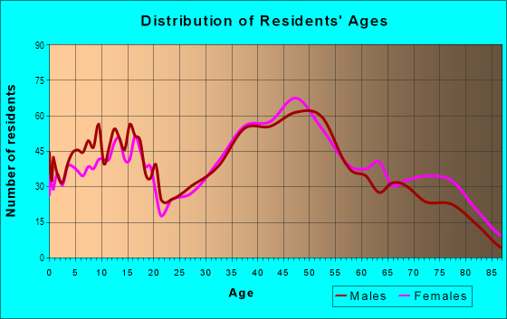
| Males: | 2,206 |
| Females: | 2,209 |
Males:
| This neighborhood: | 47.2 years |
| Whole city: | 48.1 years |
| This neighborhood: | 48.9 years |
| Whole city: | 50.5 years |
Average household size:
| Del Obispo (Del Obispo Area): | 2.5 people |
| Dana Point: | 2.3 people |
Percentage of family households:
| Del Obispo (Del Obispo Area): | 46.9% |
| Dana Point: | 42.2% |
| Here: | 55.5% |
| Dana Point: | 52.7% |
Percentage of married-couple families with children (among all households):
| Del Obispo (Del Obispo Area): | 23.7% |
| Dana Point: | 30.7% |
Percentage of single-mother households (among all households):
| Del Obispo (Del Obispo Area): | 14.3% |
| Dana Point: | 7.7% |
Percentage of never married males 15 years old and over:
Percentage of never married females 15 years old and over:
| Del Obispo (Del Obispo Area): | 13.7% |
| Dana Point: | 12.8% |
Percentage of never married females 15 years old and over:
| Del Obispo (Del Obispo Area): | 11.7% |
| city: | 12.8% |
Percentage of people that speak English not well or not at all:
| Del Obispo (Del Obispo Area): | 1.2% |
| Dana Point: | 1.2% |
Percentage of people born in this state:
Percentage of people born in another U.S. state:
Percentage of native residents but born outside the U.S.:
Percentage of foreign born residents:
| Here: | 60.4% |
| Dana Point: | 58.2% |
Percentage of people born in another U.S. state:
| Del Obispo (Del Obispo Area): | 23.2% |
| Dana Point: | 27.5% |
Percentage of native residents but born outside the U.S.:
| Here: | 0.5% |
| city: | 0.9% |
Percentage of foreign born residents:
| Here: | 16.0% |
| Dana Point: | 13.4% |
Owner-occupied
Renter-occupied

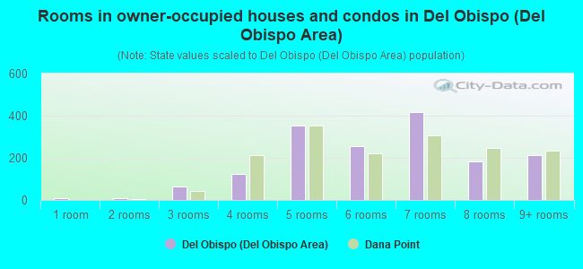
- Rooms in owner-occupied houses and condos in Del Obispo <
> - 81 room
- 72 rooms
- 643 rooms
- 1224 rooms
- 3535 rooms
- 2546 rooms
- 4197 rooms
- 1848 rooms
- 2119+ rooms
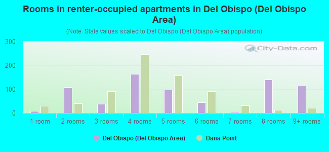
- Rooms in renter-occupied apartments in Del Obispo <
> - 81 room
- 1092 rooms
- 393 rooms
- 1644 rooms
- 985 rooms
- 446 rooms
- 47 rooms
- 1408 rooms
- 1189+ rooms
Owner-occupied
Renter-occupied
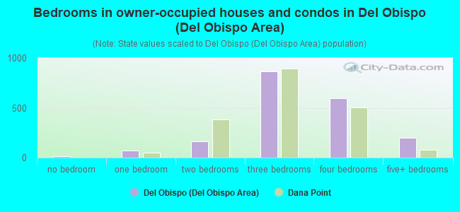
- Bedrooms in owner-occupied houses and condos in Del Obispo <
> - 15no bedroom
- 721 bedroom
- 1662 bedrooms
- 8623 bedrooms
- 5944 bedrooms
- 2015+ bedrooms
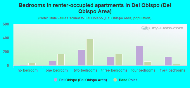
- Bedrooms in renter-occupied apartments in Del Obispo <
> - 8no bedroom
- 641 bedroom
- 2302 bedrooms
- 1293 bedrooms
- 2814 bedrooms
- 1295+ bedrooms
Average number of cars or other vehicles available in houses/condos:
Average number of cars or other vehicles available in apartments:
| This neighborhood: | 2.2 |
| Dana Point: | 2.1 |
Average number of cars or other vehicles available in apartments:
| Here: | |
| city: |
Percentage of units with a mortgage:
| Del Obispo (Del Obispo Area): | 80.5% |
| Dana Point: | 70.6% |
Average estimated value of detached houses in 2022 (109.6% of all units):
| Del Obispo (Del Obispo Area): | $1,451,034 |
| Dana Point: | $1,771,468 |
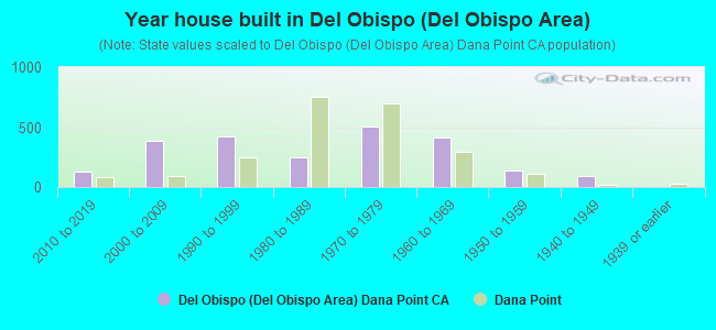
- Year house built in Del Obispo <
> - 02020 or later
- 1302010 to 2019
- 3832000 to 2009
- 4211990 to 1999
- 2511980 to 1989
- 5061970 to 1979
- 4131960 to 1969
- 1351950 to 1959
- 911940 to 1949
- 41939 or earlier

City-data.com crime index for city in 2020 (higher means more crime):
| City: | 92.7 |
| U.S. average: | 219.5 |
Travel time to work (commute)
![Travel time to work (commute)]()
- 21Less than 5 minutes
- 725 to 9 minutes
- 11510 to 14 minutes
- 10115 to 19 minutes
- 15220 to 24 minutes
- 8625 to 29 minutes
- 11830 to 34 minutes
- 2635 to 39 minutes
- 5940 to 44 minutes
- 21545 to 59 minutes
- 13160 to 89 minutes
- 7290 or more minutes

Means of transportation to work
![Means of transportation to work]()
- 55.1%1,001Drove a car alone
- 6.7%122Carpooled
- 1.4%25Bus
- 0.6%11Long-distance train or commuter rail
- 0.2%4Light rail, streetcar or trolley
- 1.5%28Motorcycle
- 8.4%152Bicycle
- 1.5%28Walked
- 5.5%99Other means
- 55.9%1,015Worked at home

Time leaving home to go to work
![Time leaving home to go to work]()
- 3512:00 a.m. to 4:59 a.m.
- 535:00 a.m. to 5:29 a.m.
- 635:30 a.m. to 5:59 a.m.
- 926:00 a.m. to 6:29 a.m.
- 806:30 a.m. to 6:59 a.m.
- 1527:00 a.m. to 7:29 a.m.
- 1527:30 a.m. to 7:59 a.m.
- 1208:00 a.m. to 8:29 a.m.
- 438:30 a.m. to 8:59 a.m.
- 729:00 a.m. to 9:59 a.m.
- 3710:00 a.m. to 10:59 a.m.
- 1411:00 a.m. to 11:59 a.m.
- 5912:00 p.m. to 3:59 p.m.
- 344:00 p.m. to 11:59 p.m.

Occupations of males:
- Percentage of males in management occupations (except farmers):
Here: 20.5% city: 17.4%
- Percentage of males in business and financial operations occupations:
Here: 6.2% city: 10.0%
- Percentage of males in computer and mathematical occupations:
Here: 2.3% city: 3.4%
- Percentage of males in architecture and engineering occupations:
Here: 6.3% city: 3.0%
- Percentage of males in life, physical, and social science occupations:
Here: 2.1% city: 0.5%
- Percentage of males in community and social services occupations:
Here: 2.0% city: 1.5%
- Percentage of males in legal occupations:
Here: 11.2% city: 3.9%
- Percentage of males in education, training, and library occupations:
Here: 1.4% city: 3.1%
- Percentage of males in service occupations:
Here: 15.2% city: 13.6%
- Percentage of males in sales and office occupations:
Here: 15.0% city: 20.8%
- Percentage of males in construction, extraction, and maintenance occupations:
Here: 13.3% city: 6.6%
- Percentage of males in production occupations:
Here: 2.8% city: 3.6%
Occupations of females:
- Percentage of females in management occupations (except farmers):
Here: 13.7% city: 14.9%
- Percentage of females in business and financial operations occupations:
Here: 6.7% city: 5.7%
- Percentage of females in life, physical, and social science occupations:
Here: 2.8% city: 1.9%
- Percentage of females in legal occupations:
Here: 3.2% city: 2.1%
- Percentage of females in education, training, and library occupations:
Here: 13.1% city: 13.0%
- Percentage of females in arts, design, entertainment, sports, and media occupations:
Here: 1.4% city: 3.1%
- Percentage of females in healthcare practitioners and technical occupations:
Here: 10.7% city: 8.7%
- Percentage of females in service occupations:
Here: 27.8% city: 15.4%
- Percentage of females in sales and office occupations:
Here: 17.3% city: 27.3%
- Percentage of females in transportation occupations:
Here: 2.3% city: 2.0%
Percentage of people 16-64 in Armed Forces:
| Del Obispo (Del Obispo Area): | 0.4% |
| Dana Point: | 0.6% |
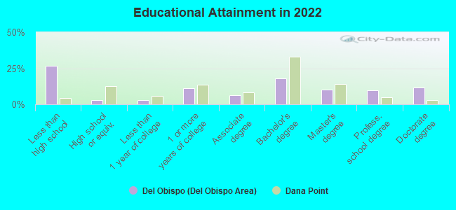
Education in this neighborhood (subdivision or community):
- Percentage of people 3 years and older in K-12 schools:
Del Obispo (Del Obispo Area): 41.5% Dana Point: 14.0%
- Percentage of people 3 years and older in undergraduate colleges:
Del Obispo (Del Obispo Area): 7.8% Dana Point: 4.4%
- Percentage of people 3 years and older in grad. or professional schools:
Del Obispo (Del Obispo Area): 2.3% Dana Point: 1.9%
- Percentage of students K-12 enrolled in private schools:
Del Obispo (Del Obispo Area): 69.3% Dana Point: 16.6%
Percentage of population below poverty level:
| Del Obispo (Del Obispo Area): | 9.3% |
| Dana Point: | 6.2% |
Median year owner moved in (as recorded in 2022):
| Del Obispo (Del Obispo Area): | 2007 |
| Dana Point: | 2009 |
Percentage of married-couple families with both working:
| Del Obispo (Del Obispo Area): | 73.1% |
| Dana Point: | 61.9% |
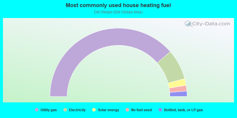
- 77.3%Utility gas
- 14.4%Electricity
- 3.2%Solar energy
- 2.7%No fuel used
- 2.5%Bottled, tank, or LP gas
Limited-access highways (interstate or state) in this neighborhood:
San Diego Fwy (I- 5)
Length: 1.46 miles
Directions: N-S, SE-NW, SW-NE
Directions: N-S, SE-NW, SW-NE
Highways in this neighborhood:
el Camino Real (Pacific Coast Hwy, State Hwy 1)
Length: 0.62 miles
Directions: E-W, SE-NW
Address range: 34348 to 34498
Directions: E-W, SE-NW
Address range: 34348 to 34498
State Hwy 1 (Coast Hwy)
Length: 0.30 miles
Direction: E-W
Direction: E-W
Roads and streets:
del Obispo St
Length: 1.69 miles
Directions: E-W, N-S, SE-NW, SW-NE
Address range: 32700 to 34299
Directions: E-W, N-S, SE-NW, SW-NE
Address range: 32700 to 34299
Cam Capistrano
Length: 1.26 miles
Directions: N-S, SE-NW, SW-NE
Address range: 33101 to 33888
Directions: N-S, SE-NW, SW-NE
Address range: 33101 to 33888
Alipaz St
Length: 0.87 miles
Directions: N-S, SE-NW, SW-NE
Address range: 32900 to 33199
Directions: N-S, SE-NW, SW-NE
Address range: 32900 to 33199
Cam del Avion
Length: 0.82 miles
Directions: E-W, N-S
Address range: 25400 to 26047
Directions: E-W, N-S
Address range: 25400 to 26047
Stonehill Dr
Length: 0.80 miles
Directions: E-W, N-S, SE-NW
Directions: E-W, N-S, SE-NW
Palo Alto St
Length: 0.65 miles
Directions: N-S, SE-NW, SW-NE
Address range: 33000 to 34113
Directions: N-S, SE-NW, SW-NE
Address range: 33000 to 34113
Valle Rd
Length: 0.59 miles
Directions: N-S, SE-NW, SW-NE
Address range: 33220 to 34469
Directions: N-S, SE-NW, SW-NE
Address range: 33220 to 34469
Doheny Park Rd
Length: 0.57 miles
Directions: N-S, SE-NW, SW-NE
Address range: 33900 to 34549
Directions: N-S, SE-NW, SW-NE
Address range: 33900 to 34549
Via del Rey
Length: 0.55 miles
Directions: E-W, SW-NE
Address range: 25500 to 32999
Directions: E-W, SW-NE
Address range: 25500 to 32999
Big Sur St
Length: 0.46 miles
Directions: N-S, SE-NW
Address range: 33000 to 33622
Directions: N-S, SE-NW
Address range: 33000 to 33622
Ave Aeropuerto
Length: 0.41 miles
Directions: E-W, N-S, SE-NW, SW-NE
Address range: 26001 to 26700
Directions: E-W, N-S, SE-NW, SW-NE
Address range: 26001 to 26700
Cll Jardin
Length: 0.39 miles
Directions: E-W, SE-NW, SW-NE
Address range: 25400 to 25799
Directions: E-W, SE-NW, SW-NE
Address range: 25400 to 25799
Mariner Dr
Length: 0.39 miles
Directions: E-W, SE-NW, SW-NE
Address range: 25425 to 25699
Directions: E-W, SE-NW, SW-NE
Address range: 25425 to 25699
Blue Fin Dr
Length: 0.38 miles
Directions: E-W, SW-NE
Address range: 33000 to 33299
Directions: E-W, SW-NE
Address range: 33000 to 33299
Westborne Dr
Length: 0.31 miles
Directions: E-W, N-S, SE-NW, SW-NE
Address range: 25300 to 25599
Directions: E-W, N-S, SE-NW, SW-NE
Address range: 25300 to 25599
Staysail Dr
Length: 0.30 miles
Directions: E-W, N-S, SE-NW, SW-NE
Address range: 25200 to 32999
Directions: E-W, N-S, SE-NW, SW-NE
Address range: 25200 to 32999
Olivo Rd
Length: 0.29 miles
Directions: E-W, N-S, SE-NW, SW-NE
Address range: 25800 to 26199
Directions: E-W, N-S, SE-NW, SW-NE
Address range: 25800 to 26199
Cll Aviador
Length: 0.28 miles
Directions: E-W, N-S, SW-NE
Address range: 32901 to 33110
Directions: E-W, N-S, SW-NE
Address range: 32901 to 33110
Sicomoro Rd
Length: 0.28 miles
Directions: E-W, N-S, SE-NW, SW-NE
Address range: 33125 to 33399
Directions: E-W, N-S, SE-NW, SW-NE
Address range: 33125 to 33399
Ave Cabrillo
Length: 0.28 miles
Direction: E-W
Address range: 25801 to 26099
Direction: E-W
Address range: 25801 to 26099
Ave Mariposa
Length: 0.28 miles
Direction: E-W
Address range: 25800 to 26099
Direction: E-W
Address range: 25800 to 26099
Astoria St
Length: 0.27 miles
Direction: N-S
Address range: 33200 to 33699
Direction: N-S
Address range: 33200 to 33699
Via Solis
Length: 0.26 miles
Directions: E-W, N-S, SE-NW, SW-NE
Address range: 25400 to 25799
Directions: E-W, N-S, SE-NW, SW-NE
Address range: 25400 to 25799
Via de Anza
Length: 0.26 miles
Directions: E-W, SE-NW, SW-NE
Address range: 26300 to 26499
Directions: E-W, SE-NW, SW-NE
Address range: 26300 to 26499
Yacht Dr
Length: 0.26 miles
Directions: E-W, SE-NW
Address range: 25200 to 25449
Directions: E-W, SE-NW
Address range: 25200 to 25449
Bridgehampton Dr
Length: 0.25 miles
Directions: N-S, SE-NW
Address range: 33600 to 33899
Directions: N-S, SE-NW
Address range: 33600 to 33899
Neptune Dr
Length: 0.25 miles
Direction: E-W
Address range: 25200 to 25599
Direction: E-W
Address range: 25200 to 25599
Cll Perfecto
Length: 0.23 miles
Directions: N-S, SW-NE
Address range: 32800 to 33110
Directions: N-S, SW-NE
Address range: 32800 to 33110
Coral Reach St
Length: 0.23 miles
Directions: N-S, SW-NE
Address range: 33300 to 33599
Directions: N-S, SW-NE
Address range: 33300 to 33599
Ave Descanso
Length: 0.23 miles
Direction: N-S
Address range: 32760 to 32978
Direction: N-S
Address range: 32760 to 32978
White Sands St
Length: 0.22 miles
Directions: E-W, SE-NW
Address range: 25600 to 25799
Directions: E-W, SE-NW
Address range: 25600 to 25799
Eastwind Dr
Length: 0.22 miles
Direction: E-W
Address range: 25500 to 25799
Direction: E-W
Address range: 25500 to 25799
Dana Pt Marina Mobile Home Estates Rd (del Obispo Trailer Park Rd)
Length: 0.21 miles
Directions: E-W, N-S, SE-NW, SW-NE
Address range: 34200 to 34219
Directions: E-W, N-S, SE-NW, SW-NE
Address range: 34200 to 34219
Rusty Anchor St
Length: 0.21 miles
Directions: E-W, SE-NW
Address range: 25501 to 25799
Directions: E-W, SE-NW
Address range: 25501 to 25799
Bayside Ln
Length: 0.21 miles
Directions: E-W, N-S, SE-NW, SW-NE
Address range: 33700 to 33799
Directions: E-W, N-S, SE-NW, SW-NE
Address range: 33700 to 33799
Via Lenita
Length: 0.21 miles
Directions: N-S, SE-NW, SW-NE
Address range: 33200 to 33498
Directions: N-S, SE-NW, SW-NE
Address range: 33200 to 33498
Windham Dr
Length: 0.21 miles
Directions: E-W, N-S, SE-NW, SW-NE
Address range: 33600 to 33799
Directions: E-W, N-S, SE-NW, SW-NE
Address range: 33600 to 33799
Bouganvillea Rd
Length: 0.20 miles
Directions: E-W, N-S, SW-NE
Address range: 33125 to 33399
Directions: E-W, N-S, SW-NE
Address range: 33125 to 33399
Goldenspring Dr
Length: 0.20 miles
Directions: E-W, SE-NW
Address range: 25500 to 25699
Directions: E-W, SE-NW
Address range: 25500 to 25699
Seaside Dr
Length: 0.20 miles
Directions: E-W, N-S, SE-NW, SW-NE
Address range: 25601 to 25799
Directions: E-W, N-S, SE-NW, SW-NE
Address range: 25601 to 25799
Palmera Rd
Length: 0.19 miles
Directions: E-W, N-S, SW-NE
Address range: 33125 to 33183
Directions: E-W, N-S, SW-NE
Address range: 33125 to 33183
Ave Pedrigal
Length: 0.18 miles
Directions: E-W, SE-NW
Address range: 25600 to 25799
Directions: E-W, SE-NW
Address range: 25600 to 25799
Chaparro Rd
Length: 0.18 miles
Directions: E-W, N-S, SE-NW
Address range: 25800 to 26099
Directions: E-W, N-S, SE-NW
Address range: 25800 to 26099
Bremerton St
Length: 0.17 miles
Direction: N-S
Address range: 33200 to 33399
Direction: N-S
Address range: 33200 to 33399
Mainsail Dr
Length: 0.17 miles
Direction: E-W
Address range: 25200 to 25399
Direction: E-W
Address range: 25200 to 25399
Capistrano by the Sea
Length: 0.17 miles
Directions: E-W, N-S, SW-NE
Directions: E-W, N-S, SW-NE
Barque Way
Length: 0.17 miles
Directions: E-W, N-S, SE-NW, SW-NE
Address range: 25200 to 32999
Directions: E-W, N-S, SE-NW, SW-NE
Address range: 25200 to 32999
Victoria Blvd
Length: 0.16 miles
Direction: E-W
Address range: 25671 to 25898
Direction: E-W
Address range: 25671 to 25898
Lighthouse Dr
Length: 0.16 miles
Direction: E-W
Direction: E-W
Brigantine Dr
Length: 0.15 miles
Direction: E-W
Address range: 25200 to 25299
Direction: E-W
Address range: 25200 to 25299
Via Mayor
Length: 0.15 miles
Directions: N-S, SE-NW
Address range: 33100 to 33299
Directions: N-S, SE-NW
Address range: 33100 to 33299
Cll Miguel
Length: 0.15 miles
Direction: N-S
Address range: 32800 to 32977
Direction: N-S
Address range: 32800 to 32977
Cll San Marcos
Length: 0.15 miles
Direction: N-S
Address range: 32800 to 32999
Direction: N-S
Address range: 32800 to 32999
Bowsprit Dr (Bowspirit)
Length: 0.14 miles
Directions: E-W, N-S, SE-NW
Address range: 25200 to 25399
Directions: E-W, N-S, SE-NW
Address range: 25200 to 25399
Blue Sail Dr
Length: 0.14 miles
Direction: E-W
Direction: E-W
Naranja Rd
Length: 0.14 miles
Direction: E-W
Address range: 25800 to 25999
Direction: E-W
Address range: 25800 to 25999
Via del Amo
Length: 0.13 miles
Directions: N-S, SW-NE
Address range: 32700 to 32899
Directions: N-S, SW-NE
Address range: 32700 to 32899
Bluff Side (Bluffside Dr)
Length: 0.13 miles
Directions: N-S, SE-NW
Address range: 32800 to 32999
Directions: N-S, SE-NW
Address range: 32800 to 32999
Caoba Rd
Length: 0.13 miles
Directions: E-W, SE-NW
Address range: 25800 to 26024
Directions: E-W, SE-NW
Address range: 25800 to 26024
Ave del Rosal
Length: 0.13 miles
Directions: N-S, SE-NW
Address range: 32800 to 32979
Directions: N-S, SE-NW
Address range: 32800 to 32979
Via la Pluma
Length: 0.12 miles
Directions: N-S, SW-NE
Address range: 33075 to 33199
Directions: N-S, SW-NE
Address range: 33075 to 33199
Perch Dr
Length: 0.12 miles
Directions: E-W, SW-NE
Address range: 25227 to 25399
Directions: E-W, SW-NE
Address range: 25227 to 25399
Park Ave
Length: 0.12 miles
Directions: E-W, SW-NE
Address range: 25601 to 26699
Directions: E-W, SW-NE
Address range: 25601 to 26699
Cll del Tesoro
Length: 0.12 miles
Directions: E-W, N-S, SE-NW, SW-NE
Address range: 32825 to 32999
Directions: E-W, N-S, SE-NW, SW-NE
Address range: 32825 to 32999
Minbrera Rd
Length: 0.12 miles
Direction: E-W
Address range: 25800 to 25979
Direction: E-W
Address range: 25800 to 25979
Sea Bluffs Dr
Length: 0.11 miles
Directions: E-W, SW-NE
Address range: 25400 to 25499
Directions: E-W, SW-NE
Address range: 25400 to 25499
Fishermans Dr
Length: 0.11 miles
Directions: E-W, SW-NE
Address range: 25600 to 25799
Directions: E-W, SW-NE
Address range: 25600 to 25799
Evans Pointe
Length: 0.11 miles
Directions: E-W, N-S, SW-NE
Address range: 25400 to 25599
Directions: E-W, N-S, SW-NE
Address range: 25400 to 25599
Las Vegas (Las Vegas Ave)
Length: 0.11 miles
Direction: SE-NW
Address range: 25700 to 25899
Direction: SE-NW
Address range: 25700 to 25899
Valley View Ct
Length: 0.11 miles
Direction: N-S
Address range: 33400 to 33599
Direction: N-S
Address range: 33400 to 33599
Manzanita Rd
Length: 0.11 miles
Direction: SW-NE
Address range: 33250 to 33349
Direction: SW-NE
Address range: 33250 to 33349
Edgewater Dr
Length: 0.10 miles
Directions: E-W, N-S, SW-NE
Address range: 33700 to 33799
Directions: E-W, N-S, SW-NE
Address range: 33700 to 33799
Harbor Point Dr
Length: 0.10 miles
Directions: E-W, N-S, SW-NE
Address range: 25700 to 25799
Directions: E-W, N-S, SW-NE
Address range: 25700 to 25799
Cll la Fuente
Length: 0.09 miles
Directions: E-W, N-S
Address range: 25600 to 26662
Directions: E-W, N-S
Address range: 25600 to 26662
Domingo Ave
Length: 0.09 miles
Direction: SE-NW
Address range: 25800 to 25909
Direction: SE-NW
Address range: 25800 to 25909
Bremerton (Bremerton St)
Length: 0.09 miles
Direction: N-S
Address range: 33500 to 33699
Direction: N-S
Address range: 33500 to 33699
Leeward Dr
Length: 0.09 miles
Directions: E-W, SE-NW
Address range: 25500 to 25599
Directions: E-W, SE-NW
Address range: 25500 to 25599
Pino Rd
Length: 0.09 miles
Directions: E-W, SW-NE
Address range: 25800 to 25924
Directions: E-W, SW-NE
Address range: 25800 to 25924
Rocky Beach Ln
Length: 0.09 miles
Direction: E-W
Address range: 25500 to 25699
Direction: E-W
Address range: 25500 to 25699
Shipside Dr
Length: 0.09 miles
Direction: N-S
Address range: 32700 to 32899
Direction: N-S
Address range: 32700 to 32899
Baladre Rd
Length: 0.09 miles
Directions: E-W, SW-NE
Address range: 25800 to 25899
Directions: E-W, SW-NE
Address range: 25800 to 25899
Shell Dr
Length: 0.09 miles
Directions: E-W, N-S, SE-NW, SW-NE
Address range: 25600 to 25799
Directions: E-W, N-S, SE-NW, SW-NE
Address range: 25600 to 25799
Breakwater Dr
Length: 0.09 miles
Directions: E-W, N-S, SW-NE
Address range: 33600 to 33699
Directions: E-W, N-S, SW-NE
Address range: 33600 to 33699
Yucca Rd
Length: 0.09 miles
Direction: SW-NE
Address range: 33275 to 33349
Direction: SW-NE
Address range: 33275 to 33349
Mainsail Way
Length: 0.09 miles
Directions: E-W, N-S, SE-NW
Address range: 25500 to 25599
Directions: E-W, N-S, SE-NW
Address range: 25500 to 25599
Ironsides Dr
Length: 0.08 miles
Directions: E-W, N-S, SE-NW, SW-NE
Address range: 33400 to 33599
Directions: E-W, N-S, SE-NW, SW-NE
Address range: 33400 to 33599
Enebro Rd
Length: 0.08 miles
Direction: SW-NE
Address range: 33125 to 33184
Direction: SW-NE
Address range: 33125 to 33184
Bayport Way
Length: 0.08 miles
Direction: N-S
Address range: 33500 to 33699
Direction: N-S
Address range: 33500 to 33699
Captains Ln
Length: 0.08 miles
Directions: N-S, SW-NE
Address range: 33700 to 38898
Directions: N-S, SW-NE
Address range: 33700 to 38898
Starboard Dr
Length: 0.08 miles
Direction: E-W
Address range: 25500 to 25599
Direction: E-W
Address range: 25500 to 25599
Saltwater Dr
Length: 0.08 miles
Direction: E-W
Address range: 25500 to 25599
Direction: E-W
Address range: 25500 to 25599
Bridgewater Ln
Length: 0.08 miles
Directions: E-W, N-S, SE-NW
Address range: 2 to 25699
Directions: E-W, N-S, SE-NW
Address range: 2 to 25699
Port Marine Dr
Length: 0.08 miles
Directions: E-W, N-S
Address range: 33500 to 33699
Directions: E-W, N-S
Address range: 33500 to 33699
Pso del Lucero
Length: 0.08 miles
Directions: E-W, N-S, SE-NW
Address range: 32900 to 32999
Directions: E-W, N-S, SE-NW
Address range: 32900 to 32999
Pso Colonial
Length: 0.08 miles
Direction: E-W
Address range: 25600 to 25799
Direction: E-W
Address range: 25600 to 25799
Ave Romero
Length: 0.08 miles
Directions: E-W, N-S, SE-NW
Address range: 25900 to 26199
Directions: E-W, N-S, SE-NW
Address range: 25900 to 26199
Scottys Cove Dr
Length: 0.08 miles
Directions: E-W, N-S, SE-NW
Address range: 33600 to 33699
Directions: E-W, N-S, SE-NW
Address range: 33600 to 33699
Tuna Dr
Length: 0.07 miles
Directions: E-W, SE-NW, SW-NE
Address range: 25200 to 25399
Directions: E-W, SE-NW, SW-NE
Address range: 25200 to 25399
Pso Molinos
Length: 0.07 miles
Direction: N-S
Address range: 33100 to 33299
Direction: N-S
Address range: 33100 to 33299
Breezewood St
Length: 0.07 miles
Direction: E-W
Address range: 25500 to 25599
Direction: E-W
Address range: 25500 to 25599
Surfside Dr
Length: 0.07 miles
Direction: N-S
Address range: 33600 to 33799
Direction: N-S
Address range: 33600 to 33799
Tidewater Dr
Length: 0.07 miles
Directions: E-W, N-S, SE-NW
Address range: 33600 to 33699
Directions: E-W, N-S, SE-NW
Address range: 33600 to 33699
Pso Miraflores
Length: 0.07 miles
Directions: E-W, N-S, SW-NE
Address range: 32900 to 32999
Directions: E-W, N-S, SW-NE
Address range: 32900 to 32999
Quail-Run
Length: 0.07 miles
Directions: E-W, SE-NW
Address range: 25601 to 25699
Directions: E-W, SE-NW
Address range: 25601 to 25699
Pso Blanco
Length: 0.07 miles
Direction: N-S
Address range: 33100 to 33299
Direction: N-S
Address range: 33100 to 33299
Ave Olivera
Length: 0.07 miles
Directions: N-S, SE-NW
Address range: 32800 to 32999
Directions: N-S, SE-NW
Address range: 32800 to 32999
Pso Cerveza
Length: 0.07 miles
Direction: SW-NE
Address range: 33100 to 33299
Direction: SW-NE
Address range: 33100 to 33299
Sea Rose Ct (Sea Rose)
Length: 0.07 miles
Directions: E-W, N-S, SW-NE
Address range: 25200 to 25339
Directions: E-W, N-S, SW-NE
Address range: 25200 to 25339
Reef Bay Pl
Length: 0.06 miles
Directions: N-S, SW-NE
Address range: 33300 to 33399
Directions: N-S, SW-NE
Address range: 33300 to 33399
Stern Wave Pl
Length: 0.06 miles
Direction: N-S
Address range: 33300 to 33499
Direction: N-S
Address range: 33300 to 33499
Sea Breeze Ct
Length: 0.06 miles
Directions: N-S, SE-NW, SW-NE
Address range: 33000 to 33099
Directions: N-S, SE-NW, SW-NE
Address range: 33000 to 33099
Mermaid Cir
Length: 0.06 miles
Direction: N-S
Address range: 32700 to 32899
Direction: N-S
Address range: 32700 to 32899
Sail Way
Length: 0.06 miles
Directions: N-S, SE-NW, SW-NE
Address range: 32700 to 32899
Directions: N-S, SE-NW, SW-NE
Address range: 32700 to 32899
Moral Rd
Length: 0.06 miles
Direction: SE-NW
Address range: 26000 to 26199
Direction: SE-NW
Address range: 26000 to 26199
Breezy Pl
Length: 0.06 miles
Directions: N-S, SW-NE
Address range: 33300 to 33499
Directions: N-S, SW-NE
Address range: 33300 to 33499
Atoll Dr
Length: 0.06 miles
Directions: E-W, N-S, SE-NW
Directions: E-W, N-S, SE-NW
Cape Bay Pl
Length: 0.06 miles
Direction: N-S
Address range: 33400 to 33499
Direction: N-S
Address range: 33400 to 33499
Cove Island Pl
Length: 0.06 miles
Directions: N-S, SW-NE
Address range: 33300 to 33399
Directions: N-S, SW-NE
Address range: 33300 to 33399
Parkplace Ln
Length: 0.06 miles
Direction: N-S
Address range: 32700 to 32899
Direction: N-S
Address range: 32700 to 32899
Pso Mono
Length: 0.05 miles
Direction: N-S
Address range: 33100 to 33299
Direction: N-S
Address range: 33100 to 33299
Parkside Way
Length: 0.05 miles
Direction: N-S
Address range: 32700 to 32899
Direction: N-S
Address range: 32700 to 32899
Surf Shoal Pl
Length: 0.05 miles
Direction: N-S
Address range: 33400 to 33499
Direction: N-S
Address range: 33400 to 33499
Nancy Jane Ct (Nancy)
Length: 0.05 miles
Directions: N-S, SW-NE
Address range: 33500 to 33599
Directions: N-S, SW-NE
Address range: 33500 to 33599
Sandy Beach Pl
Length: 0.05 miles
Directions: N-S, SW-NE
Address range: 33200 to 33299
Directions: N-S, SW-NE
Address range: 33200 to 33299
Sunridge Dr
Length: 0.05 miles
Directions: N-S, SW-NE
Address range: 33500 to 33599
Directions: N-S, SW-NE
Address range: 33500 to 33599
Lighthouse Ct
Length: 0.05 miles
Direction: N-S
Address range: 33000 to 33099
Direction: N-S
Address range: 33000 to 33099
Driftwood Ct
Length: 0.05 miles
Direction: N-S
Address range: 33000 to 33099
Direction: N-S
Address range: 33000 to 33099
Bluewater Ln
Length: 0.05 miles
Directions: N-S, SW-NE
Address range: 33700 to 33799
Directions: N-S, SW-NE
Address range: 33700 to 33799
Commodore Ct
Length: 0.05 miles
Direction: N-S
Address range: 33000 to 33099
Direction: N-S
Address range: 33000 to 33099
Galapagos St (Galapgos)
Length: 0.04 miles
Direction: N-S
Address range: 32700 to 32899
Direction: N-S
Address range: 32700 to 32899
Swanway Ct (Swanway)
Length: 0.04 miles
Direction: E-W
Address range: 25200 to 25339
Direction: E-W
Address range: 25200 to 25339
Regatta Ct
Length: 0.04 miles
Direction: N-S
Address range: 33000 to 33199
Direction: N-S
Address range: 33000 to 33199
Southwind Ct
Length: 0.04 miles
Direction: N-S
Address range: 33000 to 33199
Direction: N-S
Address range: 33000 to 33199
Buccaneer Ct
Length: 0.04 miles
Direction: N-S
Address range: 33000 to 33199
Direction: N-S
Address range: 33000 to 33199
Dolphin Ct
Length: 0.04 miles
Direction: N-S
Address range: 33000 to 33099
Direction: N-S
Address range: 33000 to 33099
Sandpiper Ct
Length: 0.04 miles
Direction: N-S
Address range: 33000 to 33199
Direction: N-S
Address range: 33000 to 33199
Outrigger Ct
Length: 0.04 miles
Direction: N-S
Address range: 33000 to 33099
Direction: N-S
Address range: 33000 to 33099
Pso del Amor
Length: 0.04 miles
Directions: N-S, SW-NE
Address range: 32800 to 32999
Directions: N-S, SW-NE
Address range: 32800 to 32999
Terrapin Ct
Length: 0.04 miles
Direction: N-S
Address range: 33000 to 33099
Direction: N-S
Address range: 33000 to 33099
Oceanwood Dr
Length: 0.04 miles
Directions: E-W, N-S, SE-NW
Address range: 25701 to 25799
Directions: E-W, N-S, SE-NW
Address range: 25701 to 25799
Surfrider Ct
Length: 0.04 miles
Direction: N-S
Address range: 33000 to 33099
Direction: N-S
Address range: 33000 to 33099
Halfmoon Ct
Length: 0.04 miles
Direction: N-S
Address range: 33000 to 33199
Direction: N-S
Address range: 33000 to 33199
Tradewind Ct
Length: 0.04 miles
Direction: N-S
Address range: 33000 to 33199
Direction: N-S
Address range: 33000 to 33199
Pso Pinto
Length: 0.03 miles
Direction: N-S
Address range: 33100 to 33199
Direction: N-S
Address range: 33100 to 33199
Santa Fe Ave (Santa Fe)
Length: 0.03 miles
Directions: E-W, N-S, SE-NW
Address range: 34133 to 34399
Directions: E-W, N-S, SE-NW
Address range: 34133 to 34399
Admiral Way
Length: 0.03 miles
Direction: E-W
Direction: E-W
Via Lorado
Length: 0.02 miles
Direction: SE-NW
Address range: 32900 to 32999
Direction: SE-NW
Address range: 32900 to 32999
Railroad features:
at and Sf Rlwy
Length: 1.42 miles
Directions: N-S, SE-NW, SW-NE
Directions: N-S, SE-NW, SW-NE
Other features:
Santa Fe Ave
Length: 0.10 miles
Directions: E-W, N-S, SE-NW, SW-NE
Address range: 34100 to 34240
Directions: E-W, N-S, SE-NW, SW-NE
Address range: 34100 to 34240