Crystal Lake neighborhood in Pontiac, Michigan (MI), 48302, 48341 detailed profile
Settings
X


Business Search - 14 Million verified businesses
Area: 1.627 square miles
Population: 5,437
Population density:
| Crystal Lake: | 3,342 people per square mile |
| Pontiac: | 3,100 people per square mile |

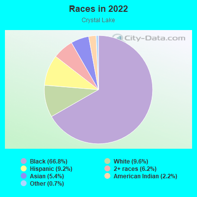
- 3,88366.8%Black
- 5589.6%White
- 5359.2%Hispanic or Latino
- 3636.2%Two or more races
- 3135.4%Asian
- 1262.2%American Indian
- 390.7%Some other race
Distribution of median household income
![Distribution of median household income]()
- 309Less than $10,000
- 242$10,000 to $19,999
- 511$20,000 to $29,999
- 739$30,000 to $39,999
- 417$40,000 to $49,999
- 272$50,000 to $59,999
- 89$60,000 to $74,999
- 289$75,000 to $99,999
- 258$100,000 to $124,999
- 124$125,000 to $149,999
- 102$150,000 to $199,999
- 91$200,000 or more

Distribution of owner-occupied house/condo value
![Distribution of owner-occupied house/condo value]()
- 386Less than $50,000
- 1,457$50,000 to $99,999
- 526$100,000 to $149,999
- 238$150,000 to $199,999
- 131$200,000 to $249,999
- 38$250,000 to $299,999
- 198$300,000 to $399,999
- 81$400,000 to $499,999
- 93$500,000 to $749,999
- 62$750,000 to $999,999
- 5$1,000,000 or more

Distribution of rent paid by renters
![Distribution of rent paid by renters]()
- 92Less than $100
- 85$100 to $199
- 85$200 to $299
- 81$300 to $399
- 525$500 to $599
- 454$600 to $699
- 557$700 to $799
- 304$800 to $899
- 500$900 to $999
- 694$1,000 to $1,249
- 160$1,250 to $1,499
- 160$1,500 to $1,999
- 4$2,000 or more

| Males: | 2,286 |
| Females: | 3,150 |
Males:
| This neighborhood: | |
| Whole city: |
| This neighborhood: | |
| Whole city: |
Percentage of family households:
| Crystal Lake: | 32.3% |
| Pontiac: | 41.3% |
| Here: | 12.3% |
| Pontiac: | 20.8% |
Percentage of married-couple families with children (among all households):
| Crystal Lake: | 19.5% |
| Pontiac: | 13.7% |
Percentage of single-mother households (among all households):
| Crystal Lake: | 55.1% |
| Pontiac: | 22.5% |
Percentage of never married males 15 years old and over:
Percentage of never married females 15 years old and over:
| Crystal Lake: | 26.5% |
| Pontiac: | 26.5% |
Percentage of never married females 15 years old and over:
| Crystal Lake: | 26.0% |
| city: | 26.1% |
Percentage of people that speak English not well or not at all:
| Crystal Lake: | 1.9% |
| Pontiac: | 4.2% |
Percentage of people born in this state:
Percentage of people born in another U.S. state:
Percentage of native residents but born outside the U.S.:
Percentage of foreign born residents:
| Here: | 68.4% |
| Pontiac: | 69.3% |
Percentage of people born in another U.S. state:
| Crystal Lake: | 22.7% |
| Pontiac: | 18.9% |
Percentage of native residents but born outside the U.S.:
| Here: | 1.0% |
| city: | 3.2% |
Percentage of foreign born residents:
| Here: | 8.0% |
| Pontiac: | 8.6% |
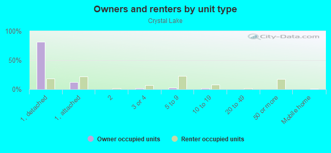
Owner-occupied
Renter-occupied

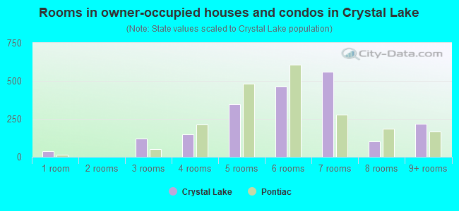
- Rooms in owner-occupied houses and condos in Crystal Lake
- 371 room
- 02 rooms
- 1213 rooms
- 1464 rooms
- 3455 rooms
- 4646 rooms
- 5597 rooms
- 1038 rooms
- 2169+ rooms
- Rooms in renter-occupied apartments in Crystal Lake
- 451 room
- 792 rooms
- 1,1923 rooms
- 6454 rooms
- 1815 rooms
- 3316 rooms
- 1637 rooms
- 3988 rooms
- 1949+ rooms
Owner-occupied
Renter-occupied
- Bedrooms in owner-occupied houses and condos in Crystal Lake
- 37no bedroom
- 331 bedroom
- 3352 bedrooms
- 1,1263 bedrooms
- 2754 bedrooms
- 135+ bedrooms
- Bedrooms in renter-occupied apartments in Crystal Lake
- 45no bedroom
- 1,2561 bedroom
- 4832 bedrooms
- 3993 bedrooms
- 4564 bedrooms
- 1295+ bedrooms
Average number of cars or other vehicles available in houses/condos:
Average number of cars or other vehicles available in apartments:
| This neighborhood: | |
| Pontiac: |
Average number of cars or other vehicles available in apartments:
| Here: | |
| city: |
Percentage of units with a mortgage:
| Crystal Lake: | 57.8% |
| Pontiac: | 55.4% |
- Year house built in Crystal Lake
- 382020 or later
- 502010 to 2019
- 1622000 to 2009
- 5081990 to 1999
- 1911980 to 1989
- 3861970 to 1979
- 2801960 to 1969
- 9201950 to 1959
- 3651940 to 1949
- 5091939 or earlier
City-data.com crime index for city in 2020 (higher means more crime):
| City: | 481.0 |
| U.S. average: | 219.5 |
Travel time to work (commute)
![Travel time to work (commute)]()
- 63Less than 5 minutes
- 1425 to 9 minutes
- 28010 to 14 minutes
- 34815 to 19 minutes
- 30320 to 24 minutes
- 15025 to 29 minutes
- 28130 to 34 minutes
- 11635 to 39 minutes
- 4840 to 44 minutes
- 9045 to 59 minutes
- 7960 to 89 minutes
- 3990 or more minutes

Means of transportation to work
![Means of transportation to work]()
- 67.2%1,244Drove a car alone
- 24.4%452Carpooled
- 7.0%130Bus
- 52.3%969Taxi
- 0.9%17Bicycle
- 14.8%274Walked
- 15.1%280Other means
- 9.8%181Worked at home

Time leaving home to go to work
![Time leaving home to go to work]()
- 6812:00 a.m. to 4:59 a.m.
- 605:00 a.m. to 5:29 a.m.
- 1345:30 a.m. to 5:59 a.m.
- 1676:00 a.m. to 6:29 a.m.
- 1846:30 a.m. to 6:59 a.m.
- 2187:00 a.m. to 7:29 a.m.
- 2517:30 a.m. to 7:59 a.m.
- 988:00 a.m. to 8:29 a.m.
- 1248:30 a.m. to 8:59 a.m.
- 1359:00 a.m. to 9:59 a.m.
- 6010:00 a.m. to 10:59 a.m.
- 6411:00 a.m. to 11:59 a.m.
- 20312:00 p.m. to 3:59 p.m.
- 1814:00 p.m. to 11:59 p.m.

Occupations of males:
- Percentage of males in management occupations (except farmers):
Here: 7.0% city: 6.1%
- Percentage of males in business and financial operations occupations:
Here: 1.1% city: 1.9%
- Percentage of males in computer and mathematical occupations:
Here: 2.0% city: 1.4%
- Percentage of males in architecture and engineering occupations:
Here: 1.4% city: 3.5%
- Percentage of males in community and social services occupations:
Here: 2.5% city: 0.9%
- Percentage of males in legal occupations:
Here: 2.3% city: 0.0%
- Percentage of males in healthcare practitioners and technical occupations:
Here: 7.0% city: 2.5%
- Percentage of males in service occupations:
Here: 21.9% city: 19.5%
- Percentage of males in sales and office occupations:
Here: 10.7% city: 8.9%
- Percentage of males in construction, extraction, and maintenance occupations:
Here: 8.5% city: 13.8%
- Percentage of males in production occupations:
Here: 30.7% city: 19.7%
- Percentage of males in transportation occupations:
Here: 1.2% city: 5.9%
- Percentage of males in material moving occupations:
Here: 1.8% city: 7.6%
Occupations of females:
- Percentage of females in management occupations (except farmers):
Here: 3.3% city: 3.7%
- Percentage of females in business and financial operations occupations:
Here: 2.6% city: 3.7%
- Percentage of females in education, training, and library occupations:
Here: 17.0% city: 6.3%
- Percentage of females in healthcare practitioners and technical occupations:
Here: 4.3% city: 4.0%
- Percentage of females in service occupations:
Here: 46.9% city: 33.1%
- Percentage of females in sales and office occupations:
Here: 13.5% city: 25.9%
- Percentage of females in production occupations:
Here: 6.2% city: 10.1%
- Percentage of females in material moving occupations:
Here: 2.7% city: 5.9%
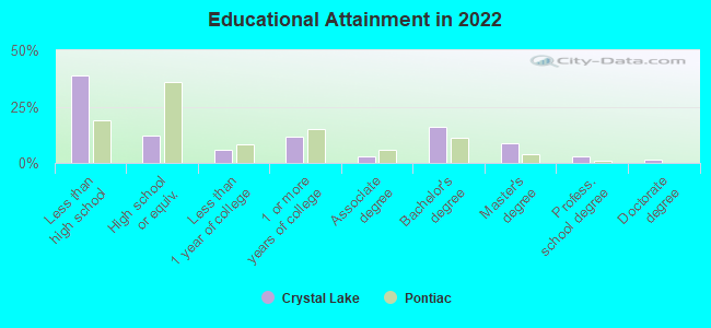
Education in this neighborhood (subdivision or community):
- Percentage of people 3 years and older in K-12 schools:
Crystal Lake: 27.5% Pontiac: 16.9%
- Percentage of people 3 years and older in undergraduate colleges:
Crystal Lake: 7.8% Pontiac: 4.8%
- Percentage of people 3 years and older in grad. or professional schools:
Crystal Lake: 4.8% Pontiac: 1.1%
- Percentage of students K-12 enrolled in private schools:
Crystal Lake: 23.2% Pontiac: 6.7%
Percentage of population below poverty level:
| Crystal Lake: | 21.4% |
| Pontiac: | 26.7% |
Percentage of married-couple families with both working:
| Crystal Lake: | 84.2% |
| Pontiac: | 59.4% |
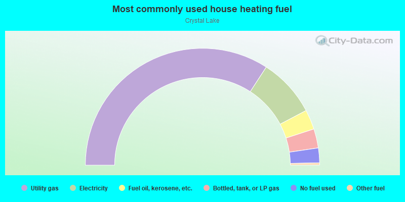
- 68.4%Utility gas
- 16.2%Electricity
- 5.5%Fuel oil, kerosene, etc.
- 5.3%Bottled, tank, or LP gas
- 4.1%No fuel used
- 0.6%Other fuel
Highways in this neighborhood:
S Telegraph Rd (US Hwy 24)
Length: 0.29 miles
Direction: SE-NW
Address range: 1939 to 2009
Direction: SE-NW
Address range: 1939 to 2009
Telegraph Rd (US Hwy 24)
Length: 0.24 miles
Direction: SE-NW
Address range: 601 to 699
Direction: SE-NW
Address range: 601 to 699
Roads and streets:
Franklin Rd
Length: 1.63 miles
Directions: E-W, N-S, SE-NW, SW-NE
Address range: 35 to 1399
Directions: E-W, N-S, SE-NW, SW-NE
Address range: 35 to 1399
Golf Dr
Length: 1.57 miles
Directions: E-W, SE-NW, SW-NE
Address range: 400 to 1199
Directions: E-W, SE-NW, SW-NE
Address range: 400 to 1199
Bagley St
Length: 1.38 miles
Direction: N-S
Address range: 160 to 699
Direction: N-S
Address range: 160 to 699
Motor St
Length: 1.06 miles
Direction: N-S
Address range: 150 to 699
Direction: N-S
Address range: 150 to 699
Gillespie Ave
Length: 0.69 miles
Direction: E-W
Address range: 340 to 599
Direction: E-W
Address range: 340 to 599
Berwick Blvd
Length: 0.60 miles
Directions: E-W, SE-NW, SW-NE
Address range: 500 to 1099
Directions: E-W, SE-NW, SW-NE
Address range: 500 to 1099
Arthur Ave
Length: 0.58 miles
Directions: E-W, SW-NE
Address range: 446 to 799
Directions: E-W, SW-NE
Address range: 446 to 799
Oaklawn Dr
Length: 0.57 miles
Directions: E-W, N-S, SE-NW, SW-NE
Address range: 100 to 1399
Directions: E-W, N-S, SE-NW, SW-NE
Address range: 100 to 1399
Luther Ave
Length: 0.55 miles
Direction: E-W
Address range: 450 to 659
Direction: E-W
Address range: 450 to 659
Pearsall Ave
Length: 0.55 miles
Directions: E-W, SW-NE
Address range: 450 to 659
Directions: E-W, SW-NE
Address range: 450 to 659
Alton Ave
Length: 0.55 miles
Direction: E-W
Address range: 450 to 659
Direction: E-W
Address range: 450 to 659
Rockwell Ave
Length: 0.54 miles
Direction: E-W
Address range: 100 to 379
Direction: E-W
Address range: 100 to 379
Fildew Ave
Length: 0.54 miles
Direction: E-W
Address range: 450 to 659
Direction: E-W
Address range: 450 to 659
Canterbury Dr
Length: 0.51 miles
Directions: E-W, N-S, SW-NE
Address range: 900 to 1099
Directions: E-W, N-S, SW-NE
Address range: 900 to 1099
Branch St
Length: 0.51 miles
Directions: N-S, SE-NW, SW-NE
Address range: 109 to 599
Directions: N-S, SE-NW, SW-NE
Address range: 109 to 599
Argyle Ave
Length: 0.50 miles
Directions: E-W, SE-NW, SW-NE
Address range: 886 to 1099
Directions: E-W, SE-NW, SW-NE
Address range: 886 to 1099
Friendly St
Length: 0.46 miles
Direction: E-W
Address range: 200 to 599
Direction: E-W
Address range: 200 to 599
California Ave
Length: 0.45 miles
Direction: E-W
Address range: 451 to 699
Direction: E-W
Address range: 451 to 699
Colorado Ave
Length: 0.45 miles
Direction: E-W
Address range: 450 to 619
Direction: E-W
Address range: 450 to 619
South Blvd W
Length: 0.45 miles
Direction: E-W
Address range: 288 to 499
Direction: E-W
Address range: 288 to 499
Wyoming Ave
Length: 0.45 miles
Direction: E-W
Address range: 450 to 619
Direction: E-W
Address range: 450 to 619
Nebraska Ave
Length: 0.45 miles
Direction: E-W
Address range: 449 to 619
Direction: E-W
Address range: 449 to 619
Nevada Ave
Length: 0.45 miles
Direction: E-W
Address range: 450 to 619
Direction: E-W
Address range: 450 to 619
Montana Ave
Length: 0.45 miles
Direction: E-W
Address range: 450 to 619
Direction: E-W
Address range: 450 to 619
Crystal Lake Dr
Length: 0.45 miles
Direction: E-W
Address range: 150 to 349
Direction: E-W
Address range: 150 to 349
Hughes Ave
Length: 0.44 miles
Direction: E-W
Address range: 170 to 349
Direction: E-W
Address range: 170 to 349
Harrison St
Length: 0.44 miles
Direction: E-W
Address range: 169 to 339
Direction: E-W
Address range: 169 to 339
W Wilson Ave
Length: 0.44 miles
Direction: E-W
Address range: 170 to 399
Direction: E-W
Address range: 170 to 399
Fisher Ave
Length: 0.44 miles
Direction: E-W
Address range: 150 to 331
Direction: E-W
Address range: 150 to 331
Howard Mc Neill St
Length: 0.44 miles
Directions: E-W, N-S, SW-NE
Address range: 100 to 499
Directions: E-W, N-S, SW-NE
Address range: 100 to 499
Brush St
Length: 0.42 miles
Direction: E-W
Address range: 40 to 249
Direction: E-W
Address range: 40 to 249
Rapid St
Length: 0.42 miles
Direction: E-W
Address range: 170 to 399
Direction: E-W
Address range: 170 to 399
Hood Rd
Length: 0.41 miles
Directions: N-S, SE-NW, SW-NE
Address range: 1400 to 1799
Directions: N-S, SE-NW, SW-NE
Address range: 1400 to 1799
Walter Dr
Length: 0.41 miles
Directions: E-W, N-S, SW-NE
Directions: E-W, N-S, SW-NE
Orchard Lake Rd
Length: 0.41 miles
Direction: SW-NE
Address range: 800 to 999
Direction: SW-NE
Address range: 800 to 999
Wrenn St
Length: 0.39 miles
Directions: E-W, N-S, SE-NW, SW-NE
Address range: 540 to 719
Directions: E-W, N-S, SE-NW, SW-NE
Address range: 540 to 719
Karlwalter Dr
Length: 0.38 miles
Directions: E-W, N-S, SE-NW
Directions: E-W, N-S, SE-NW
Ditmar Ave
Length: 0.37 miles
Direction: E-W
Address range: 450 to 699
Direction: E-W
Address range: 450 to 699
Clovese St
Length: 0.34 miles
Direction: E-W
Address range: 1 to 199
Direction: E-W
Address range: 1 to 199
King Ln
Length: 0.34 miles
Directions: E-W, N-S, SE-NW, SW-NE
Directions: E-W, N-S, SE-NW, SW-NE
Oak Rdige Dr
Length: 0.34 miles
Directions: E-W, N-S, SE-NW, SW-NE
Directions: E-W, N-S, SE-NW, SW-NE
Warner St
Length: 0.30 miles
Direction: E-W
Address range: 1 to 119
Direction: E-W
Address range: 1 to 119
Hess St
Length: 0.29 miles
Directions: E-W, SE-NW
Address range: 1 to 99
Directions: E-W, SE-NW
Address range: 1 to 99
Berkley Ave
Length: 0.29 miles
Directions: E-W, SE-NW, SW-NE
Address range: 1060 to 1198
Directions: E-W, SE-NW, SW-NE
Address range: 1060 to 1198
Orton Ave
Length: 0.28 miles
Direction: E-W
Address range: 1 to 99
Direction: E-W
Address range: 1 to 99
Dover Rd
Length: 0.27 miles
Directions: E-W, SE-NW
Address range: 1000 to 1199
Directions: E-W, SE-NW
Address range: 1000 to 1199
Rotsel Rd
Length: 0.25 miles
Direction: E-W
Address range: 1500 to 1571
Direction: E-W
Address range: 1500 to 1571
Lake St
Length: 0.20 miles
Directions: N-S, SE-NW
Address range: 76 to 299
Directions: N-S, SE-NW
Address range: 76 to 299
Houston St
Length: 0.20 miles
Direction: E-W
Address range: 50 to 145
Direction: E-W
Address range: 50 to 145
Roland St (Roland Rd)
Length: 0.17 miles
Directions: E-W, N-S, SW-NE
Address range: 400 to 599
Directions: E-W, N-S, SW-NE
Address range: 400 to 599
Irene St
Length: 0.16 miles
Directions: E-W, N-S
Address range: 80 to 451
Directions: E-W, N-S
Address range: 80 to 451
Avon Rd
Length: 0.14 miles
Directions: N-S, SE-NW
Address range: 480 to 543
Directions: N-S, SE-NW
Address range: 480 to 543
Oak Ridge Dr
Length: 0.14 miles
Directions: E-W, N-S, SE-NW
Address range: 186 to 365
Directions: E-W, N-S, SE-NW
Address range: 186 to 365
Oak Valley Dr
Length: 0.12 miles
Directions: N-S, SE-NW
Address range: 1100 to 1199
Directions: N-S, SE-NW
Address range: 1100 to 1199
Barren Oaks Dr
Length: 0.12 miles
Direction: E-W
Address range: 869 to 911
Direction: E-W
Address range: 869 to 911
Oxford Rd
Length: 0.10 miles
Direction: SE-NW
Address range: 1000 to 1099
Direction: SE-NW
Address range: 1000 to 1099
Fairfax Ave
Length: 0.07 miles
Directions: E-W, SW-NE
Directions: E-W, SW-NE
Grant St
Length: 0.06 miles
Directions: N-S, SE-NW, SW-NE
Address range: 1 to 29
Directions: N-S, SE-NW, SW-NE
Address range: 1 to 29
Linfere St
Length: 0.06 miles
Direction: SE-NW
Address range: 1 to 19
Direction: SE-NW
Address range: 1 to 19
McAffe
Length: 0.06 miles
Direction: E-W
Direction: E-W
Quick Ct
Length: 0.06 miles
Direction: N-S
Address range: 1 to 199
Direction: N-S
Address range: 1 to 199
Railroad features:
Grand Trunk Western RR
Length: 1.03 miles
Directions: E-W, SE-NW
Directions: E-W, SE-NW
Other features:
Clinton Riv
Length: 1.99 miles
Directions: E-W, N-S, SE-NW, SW-NE
Directions: E-W, N-S, SE-NW, SW-NE