Buckhead neighborhood in Atlanta, Georgia (GA), 30305, 30309, 30318, 30324, 30327 detailed profile
Settings
X


Business Search - 14 Million verified businesses
Area: 4.778 square miles
Population: 2,830
Population density:
| Buckhead: | 592 people per square mile |
| Atlanta: | 3,788 people per square mile |

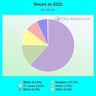
- 1,75361.8%White
- 38813.7%Hispanic or Latino
- 2789.8%Two or more races
- 2227.8%Asian
- 1866.6%Black
- 110.4%Some other race
Median household income in 2022:
| Buckhead: | $250,001 |
| Atlanta: | $83,251 |
Distribution of median household income
![Distribution of median household income]()
- 25Less than $10,000
- 9$10,000 to $19,999
- 12$20,000 to $29,999
- 21$30,000 to $39,999
- 87$40,000 to $49,999
- 57$50,000 to $59,999
- 54$60,000 to $74,999
- 72$75,000 to $99,999
- 155$100,000 to $124,999
- 21$125,000 to $149,999
- 101$150,000 to $199,999
- 454$200,000 or more

Distribution of owner-occupied house/condo value
![Distribution of owner-occupied house/condo value]()
- 12Less than $50,000
- 12$50,000 to $99,999
- 19$150,000 to $199,999
- 30$200,000 to $249,999
- 66$250,000 to $299,999
- 72$300,000 to $399,999
- 30$400,000 to $499,999
- 81$500,000 to $749,999
- 21$750,000 to $999,999
- 386$1,000,000 or more

Distribution of rent paid by renters
![Distribution of rent paid by renters]()
- 27$500 to $599
- 31$1,250 to $1,499
- 9$1,500 to $1,999
- 84$2,000 or more

Median rent in 2022:
| Buckhead: | $3,250 |
| Atlanta: | $1,477 |
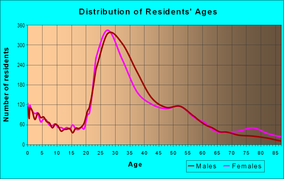
| Males: | 1,314 |
| Females: | 1,516 |
Males:
| This neighborhood: | 27.9 years |
| Whole city: | 33.7 years |
| This neighborhood: | 45.2 years |
| Whole city: | 34.3 years |
Average household size:
| Buckhead: | 3.5 people |
| Atlanta: | 2.0 people |
Percentage of family households:
| Buckhead: | 56.3% |
| Atlanta: | 31.6% |
| Here: | 61.5% |
| Atlanta: | 24.9% |
Percentage of married-couple families with children (among all households):
| Buckhead: | 19.4% |
| Atlanta: | 23.2% |
Percentage of single-mother households (among all households):
| Buckhead: | 8.9% |
| Atlanta: | 22.0% |
Percentage of never married males 15 years old and over:
Percentage of never married females 15 years old and over:
| Buckhead: | 15.4% |
| Atlanta: | 28.0% |
Percentage of never married females 15 years old and over:
| Buckhead: | 18.0% |
| city: | 26.3% |
Percentage of people born in this state:
Percentage of people born in another U.S. state:
Percentage of native residents but born outside the U.S.:
Percentage of foreign born residents:
| Here: | 45.1% |
| Atlanta: | 46.3% |
Percentage of people born in another U.S. state:
| Buckhead: | 45.2% |
| Atlanta: | 43.2% |
Percentage of native residents but born outside the U.S.:
| Here: | 1.3% |
| city: | 2.0% |
Percentage of foreign born residents:
| Here: | 8.3% |
| Atlanta: | 8.5% |
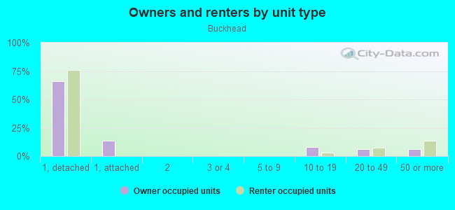
Owner-occupied
Renter-occupied

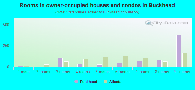
- Rooms in owner-occupied houses and condos in Buckhead
- 151 room
- 02 rooms
- 1053 rooms
- 404 rooms
- 295 rooms
- 506 rooms
- 687 rooms
- 868 rooms
- 3829+ rooms
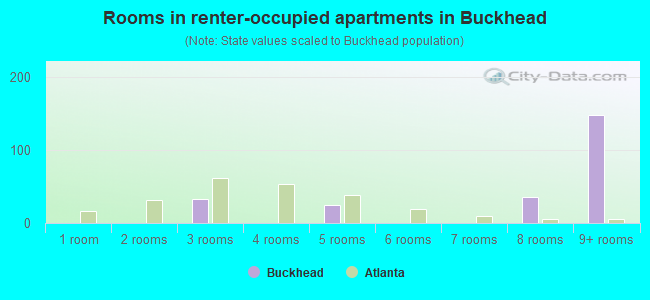
- Rooms in renter-occupied apartments in Buckhead
- 01 room
- 02 rooms
- 333 rooms
- 04 rooms
- 255 rooms
- 06 rooms
- 07 rooms
- 358 rooms
- 1489+ rooms
Owner-occupied
Renter-occupied
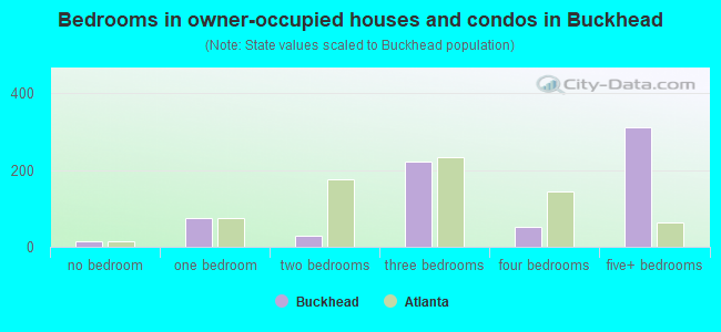
- Bedrooms in owner-occupied houses and condos in Buckhead
- 15no bedroom
- 741 bedroom
- 292 bedrooms
- 2223 bedrooms
- 534 bedrooms
- 3115+ bedrooms
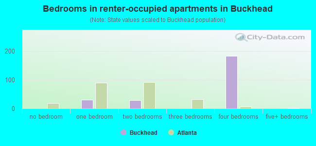
- Bedrooms in renter-occupied apartments in Buckhead
- 0no bedroom
- 301 bedroom
- 292 bedrooms
- 03 bedrooms
- 1834 bedrooms
- 05+ bedrooms
Average number of cars or other vehicles available in houses/condos:
Average number of cars or other vehicles available in apartments:
| This neighborhood: | 2.6 |
| Atlanta: | 1.6 |
Average number of cars or other vehicles available in apartments:
| Here: | 3.0 |
| city: | 1.0 |
Percentage of units with a mortgage:
| Buckhead: | 69.2% |
| Atlanta: | 72.0% |
Housing prices:
- Average estimated value of detached houses in 2022 (87.8% of all units):
Buckhead: $1,919,746 Atlanta: $673,143
- Average estimated value of townhouses or other attached units in 2022 (12.1% of all units):
This neighborhood: $398,464 city: $475,155
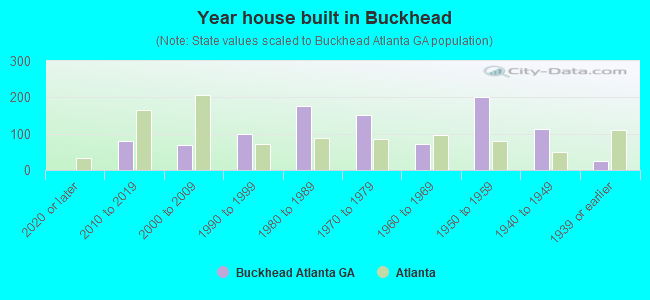
- Year house built in Buckhead
- 02020 or later
- 802010 to 2019
- 682000 to 2009
- 1001990 to 1999
- 1751980 to 1989
- 1511970 to 1979
- 711960 to 1969
- 2011950 to 1959
- 1131940 to 1949
- 261939 or earlier
City-data.com crime index for city in 2020 (higher means more crime):
| City: | 140.2 |
| U.S. average: | 219.5 |
Travel time to work (commute)
![Travel time to work (commute)]()
- 1365 to 9 minutes
- 18710 to 14 minutes
- 39615 to 19 minutes
- 40420 to 24 minutes
- 17425 to 29 minutes
- 32130 to 34 minutes
- 5235 to 39 minutes
- 7040 to 44 minutes
- 8345 to 59 minutes
- 1660 to 89 minutes
- 2790 or more minutes

Means of transportation to work
![Means of transportation to work]()
- 82.9%1,065Drove a car alone
- 3.4%44Carpooled
- 1.0%13Taxi
- 11.1%142Walked
- 2.5%32Worked at home

Time leaving home to go to work
![Time leaving home to go to work]()
- 1612:00 a.m. to 4:59 a.m.
- 156:00 a.m. to 6:29 a.m.
- 1176:30 a.m. to 6:59 a.m.
- 2687:00 a.m. to 7:29 a.m.
- 2777:30 a.m. to 7:59 a.m.
- 3698:00 a.m. to 8:29 a.m.
- 1078:30 a.m. to 8:59 a.m.
- 3439:00 a.m. to 9:59 a.m.
- 17710:00 a.m. to 10:59 a.m.
- 13712:00 p.m. to 3:59 p.m.
- 134:00 p.m. to 11:59 p.m.

Occupations of males:
- Percentage of males in management occupations (except farmers):
Here: 20.6% city: 16.5%
- Percentage of males in business and financial operations occupations:
Here: 17.6% city: 10.8%
- Percentage of males in computer and mathematical occupations:
Here: 13.5% city: 8.5%
- Percentage of males in architecture and engineering occupations:
Here: 15.0% city: 4.2%
- Percentage of males in legal occupations:
Here: 9.0% city: 3.3%
- Percentage of males in education, training, and library occupations:
Here: 3.0% city: 5.1%
- Percentage of males in arts, design, entertainment, sports, and media occupations:
Here: 5.4% city: 4.8%
- Percentage of males in healthcare practitioners and technical occupations:
Here: 4.7% city: 3.4%
- Percentage of males in service occupations:
Here: 19.3% city: 11.5%
- Percentage of males in sales and office occupations:
Here: 38.8% city: 15.1%
- Percentage of males in transportation occupations:
Here: 6.9% city: 4.0%
Occupations of females:
- Percentage of females in management occupations (except farmers):
Here: 22.5% city: 14.0%
- Percentage of females in business and financial operations occupations:
Here: 4.0% city: 10.8%
- Percentage of females in architecture and engineering occupations:
Here: 4.3% city: 1.4%
- Percentage of females in community and social services occupations:
Here: 4.3% city: 2.5%
- Percentage of females in legal occupations:
Here: 5.0% city: 3.1%
- Percentage of females in education, training, and library occupations:
Here: 30.5% city: 8.9%
- Percentage of females in arts, design, entertainment, sports, and media occupations:
Here: 5.3% city: 4.9%
- Percentage of females in healthcare practitioners and technical occupations:
Here: 5.0% city: 7.6%
- Percentage of females in service occupations:
Here: 4.9% city: 13.9%
- Percentage of females in sales and office occupations:
Here: 18.5% city: 21.9%
- Percentage of females in production occupations:
Here: 14.5% city: 1.9%
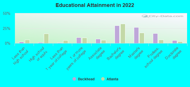
Education in this neighborhood (subdivision or community):
- Percentage of people 3 years and older in K-12 schools:
Buckhead: 34.3% Atlanta: 12.5%
- Percentage of people 3 years and older in undergraduate colleges:
Buckhead: 2.0% Atlanta: 8.9%
- Percentage of people 3 years and older in grad. or professional schools:
Buckhead: 1.6% Atlanta: 3.3%
- Percentage of students K-12 enrolled in private schools:
Buckhead: 54.5% Atlanta: 22.5%
Percentage of population below poverty level:
| Buckhead: | 2.6% |
| Atlanta: | 17.3% |
Median year owner moved in (as recorded in 2022):
Median year renter moved in (as recorded in 2022):
| Buckhead: | 2010 |
| Atlanta: | 2015 |
Median year renter moved in (as recorded in 2022):
| Buckhead: | 2016 |
| Atlanta: | 2020 |
Percentage of married-couple families with both working:
| Buckhead: | 65.6% |
| Atlanta: | 79.0% |
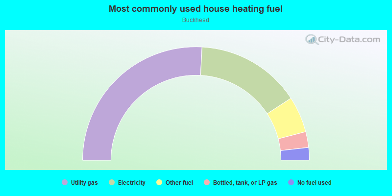
- 51.7%Utility gas
- 29.9%Electricity
- 10.3%Other fuel
- 4.5%Bottled, tank, or LP gas
- 3.6%No fuel used
Limited-access highways (interstate or state) in this neighborhood:
State Rte 403 (I- 85)
Length: 4.31 miles
Directions: E-W, SW-NE
Directions: E-W, SW-NE
State Rte 401 (I- 75)
Length: 1.85 miles
Directions: E-W, N-S, SE-NW
Directions: E-W, N-S, SE-NW
Highways in this neighborhood:
US Hwy 19 (Peachtree Rd, State Rte 9)
Length: 3.36 miles
Directions: N-S, SE-NW, SW-NE
Address range: 1670 to 2406
Directions: N-S, SE-NW, SW-NE
Address range: 1670 to 2406
Northside Pkwy NW (State Rte 3, US Hwy 41)
Length: 1.60 miles
Direction: N-S
Address range: 1753 to 2614
Direction: N-S
Address range: 1753 to 2614
State Rte 237 (Piedmont Rd NE)
Length: 0.43 miles
Direction: N-S
Address range: 2135 to 2410
Direction: N-S
Address range: 2135 to 2410
State Rte 13 (Spring Buford Con)
Length: 0.40 miles
Directions: E-W, SW-NE
Address range: 2006 to 2077
Directions: E-W, SW-NE
Address range: 2006 to 2077
State Rte 400
Length: 0.10 miles
Directions: N-S, SW-NE
Directions: N-S, SW-NE
Roads and streets:
Peachtree Battle Ave NW
Length: 3.28 miles
Directions: E-W, SE-NW, SW-NE
Address range: 2 to 1099
Directions: E-W, SE-NW, SW-NE
Address range: 2 to 1099
Collier Rd NW
Length: 1.58 miles
Directions: E-W, SE-NW, SW-NE
Address range: 1 to 843
Directions: E-W, SE-NW, SW-NE
Address range: 1 to 843
Howell Mill Rd
Length: 1.44 miles
Directions: N-S, SE-NW, SW-NE
Address range: 1861 to 2570
Directions: N-S, SE-NW, SW-NE
Address range: 1861 to 2570
Woodward Way NW
Length: 1.28 miles
Directions: E-W, N-S, SE-NW, SW-NE
Address range: 325 to 799
Directions: E-W, N-S, SE-NW, SW-NE
Address range: 325 to 799
Dellwood Dr NW
Length: 1.26 miles
Directions: E-W, N-S, SE-NW, SW-NE
Address range: 1900 to 2599
Directions: E-W, N-S, SE-NW, SW-NE
Address range: 1900 to 2599
Armour Dr NE
Length: 1.12 miles
Directions: E-W, N-S, SE-NW, SW-NE
Address range: 1 to 519
Directions: E-W, N-S, SE-NW, SW-NE
Address range: 1 to 519
Peachtree Hills Ave NE
Length: 1.11 miles
Directions: E-W, SW-NE
Address range: 1 to 424
Directions: E-W, SW-NE
Address range: 1 to 424
Lindbergh Dr
Length: 0.95 miles
Directions: E-W, SE-NW
Address range: 1 to 696
Directions: E-W, SE-NW
Address range: 1 to 696
Wesley Dr NW
Length: 0.90 miles
Directions: E-W, N-S, SE-NW, SW-NE
Address range: 600 to 903
Directions: E-W, N-S, SE-NW, SW-NE
Address range: 600 to 903
Fairhaven Cir NE
Length: 0.84 miles
Directions: E-W, N-S, SE-NW, SW-NE
Address range: 1980 to 2321
Directions: E-W, N-S, SE-NW, SW-NE
Address range: 1980 to 2321
Woodward Way NW (Woodward Way NE)
Length: 0.82 miles
Directions: E-W, N-S, SW-NE
Address range: 2257 to 2699
Directions: E-W, N-S, SW-NE
Address range: 2257 to 2699
Brookview Dr NW
Length: 0.80 miles
Directions: E-W, N-S, SE-NW, SW-NE
Address range: 1900 to 2299
Directions: E-W, N-S, SE-NW, SW-NE
Address range: 1900 to 2299
Camden Rd NE
Length: 0.79 miles
Directions: E-W, N-S, SW-NE
Address range: 1 to 399
Directions: E-W, N-S, SW-NE
Address range: 1 to 399
Huntington Rd NE
Length: 0.70 miles
Directions: E-W, N-S, SE-NW, SW-NE
Address range: 1 to 299
Directions: E-W, N-S, SE-NW, SW-NE
Address range: 1 to 299
Brighton Rd NE
Length: 0.67 miles
Directions: E-W, N-S, SE-NW, SW-NE
Address range: 1 to 299
Directions: E-W, N-S, SE-NW, SW-NE
Address range: 1 to 299
Virginia Pl NE
Length: 0.65 miles
Directions: E-W, N-S, SE-NW, SW-NE
Address range: 2100 to 2413
Directions: E-W, N-S, SE-NW, SW-NE
Address range: 2100 to 2413
Manor Ridge Dr NW
Length: 0.65 miles
Directions: E-W, SE-NW
Address range: 300 to 599
Directions: E-W, SE-NW
Address range: 300 to 599
Ottley Dr NE
Length: 0.63 miles
Direction: SW-NE
Address range: 100 to 299
Direction: SW-NE
Address range: 100 to 299
Plasters Ave NE
Length: 0.59 miles
Directions: E-W, SW-NE
Address range: 396 to 599
Directions: E-W, SW-NE
Address range: 396 to 599
Peachtree Battle Cir NW
Length: 0.57 miles
Directions: E-W, N-S, SE-NW, SW-NE
Address range: 800 to 1099
Directions: E-W, N-S, SE-NW, SW-NE
Address range: 800 to 1099
Longwood Dr NW
Length: 0.56 miles
Direction: E-W
Address range: 600 to 899
Direction: E-W
Address range: 600 to 899
Peachtree Park Dr NE
Length: 0.53 miles
Directions: E-W, N-S, SE-NW, SW-NE
Address range: 145 to 899
Directions: E-W, N-S, SE-NW, SW-NE
Address range: 145 to 899
Walthall Dr NW
Length: 0.53 miles
Directions: N-S, SE-NW, SW-NE
Address range: 1700 to 2099
Directions: N-S, SE-NW, SW-NE
Address range: 1700 to 2099
Wilson Rd NW
Length: 0.52 miles
Directions: E-W, SE-NW, SW-NE
Address range: 600 to 899
Directions: E-W, SE-NW, SW-NE
Address range: 600 to 899
Dean Dr NW
Length: 0.51 miles
Directions: E-W, N-S, SE-NW, SW-NE
Address range: 888 to 1099
Directions: E-W, N-S, SE-NW, SW-NE
Address range: 888 to 1099
Northcliffe Dr NW
Length: 0.50 miles
Directions: E-W, N-S, SE-NW, SW-NE
Address range: 801 to 1099
Directions: E-W, N-S, SE-NW, SW-NE
Address range: 801 to 1099
26th St NW
Length: 0.50 miles
Directions: E-W, N-S, SE-NW
Address range: 1 to 499
Directions: E-W, N-S, SE-NW
Address range: 1 to 499
McKinley Rd NW
Length: 0.49 miles
Directions: E-W, N-S, SE-NW, SW-NE
Address range: 2000 to 2199
Directions: E-W, N-S, SE-NW, SW-NE
Address range: 2000 to 2199
Lindmont Cir NE
Length: 0.48 miles
Directions: E-W, N-S, SE-NW, SW-NE
Address range: 2101 to 2399
Directions: E-W, N-S, SE-NW, SW-NE
Address range: 2101 to 2399
Springdale Dr NE
Length: 0.47 miles
Directions: E-W, SW-NE
Address range: 100 to 330
Directions: E-W, SW-NE
Address range: 100 to 330
Habersham Rd NW
Length: 0.47 miles
Directions: N-S, SE-NW
Address range: 2480 to 2669
Directions: N-S, SE-NW
Address range: 2480 to 2669
Greystone Rd NW
Length: 0.46 miles
Directions: E-W, N-S, SW-NE
Address range: 1800 to 1999
Directions: E-W, N-S, SW-NE
Address range: 1800 to 1999
Montview Dr NW
Length: 0.44 miles
Directions: N-S, SE-NW
Address range: 2200 to 2599
Directions: N-S, SE-NW
Address range: 2200 to 2599
Eureka Dr NE
Length: 0.43 miles
Directions: E-W, SW-NE
Address range: 100 to 399
Directions: E-W, SW-NE
Address range: 100 to 399
Palisades Rd NE
Length: 0.43 miles
Directions: E-W, SW-NE
Address range: 1 to 199
Directions: E-W, SW-NE
Address range: 1 to 199
Overbrook Dr NW
Length: 0.42 miles
Directions: E-W, N-S, SE-NW, SW-NE
Address range: 400 to 626
Directions: E-W, N-S, SE-NW, SW-NE
Address range: 400 to 626
Brookdale Dr NW
Length: 0.41 miles
Directions: N-S, SE-NW, SW-NE
Address range: 2500 to 2699
Directions: N-S, SE-NW, SW-NE
Address range: 2500 to 2699
Dan Ln NE
Length: 0.40 miles
Directions: E-W, N-S, SE-NW, SW-NE
Address range: 552 to 627
Directions: E-W, N-S, SE-NW, SW-NE
Address range: 552 to 627
Terrace Dr NE
Length: 0.39 miles
Directions: E-W, N-S, SE-NW, SW-NE
Address range: 1 to 299
Directions: E-W, N-S, SE-NW, SW-NE
Address range: 1 to 299
Haven Ridge Dr NW
Length: 0.39 miles
Direction: N-S
Address range: 2224 to 2441
Direction: N-S
Address range: 2224 to 2441
Armour Cir NE
Length: 0.38 miles
Directions: E-W, N-S, SE-NW, SW-NE
Address range: 400 to 599
Directions: E-W, N-S, SE-NW, SW-NE
Address range: 400 to 599
Norfleet Rd NW
Length: 0.38 miles
Directions: E-W, SW-NE
Address range: 600 to 799
Directions: E-W, SW-NE
Address range: 600 to 799
Springlake Dr NW
Length: 0.37 miles
Directions: E-W, N-S, SW-NE
Address range: 1990 to 2117
Directions: E-W, N-S, SW-NE
Address range: 1990 to 2117
Channing Dr NW
Length: 0.37 miles
Directions: E-W, N-S, SE-NW, SW-NE
Address range: 600 to 799
Directions: E-W, N-S, SE-NW, SW-NE
Address range: 600 to 799
Woodley Dr NW
Length: 0.37 miles
Direction: E-W
Address range: 700 to 899
Direction: E-W
Address range: 700 to 899
Rivers Rd NW (Habersham Rd NW)
Length: 0.36 miles
Directions: E-W, N-S, SW-NE
Address range: 2400 to 2633
Directions: E-W, N-S, SW-NE
Address range: 2400 to 2633
Wakefield Dr NE
Length: 0.36 miles
Directions: E-W, N-S, SW-NE
Address range: 1 to 199
Directions: E-W, N-S, SW-NE
Address range: 1 to 199
28th St NW
Length: 0.36 miles
Direction: E-W
Address range: 1 to 99
Direction: E-W
Address range: 1 to 99
Alden Ave NW
Length: 0.36 miles
Directions: N-S, SE-NW, SW-NE
Address range: 1 to 200
Directions: N-S, SE-NW, SW-NE
Address range: 1 to 200
Nacoochee Dr NW
Length: 0.35 miles
Directions: E-W, N-S, SE-NW, SW-NE
Address range: 100 to 299
Directions: E-W, N-S, SE-NW, SW-NE
Address range: 100 to 299
Muscogee Ave NW
Length: 0.35 miles
Directions: E-W, N-S, SE-NW
Address range: 20 to 99
Directions: E-W, N-S, SE-NW
Address range: 20 to 99
Hurst Dr NE
Length: 0.35 miles
Directions: E-W, N-S, SE-NW
Address range: 2300 to 2451
Directions: E-W, N-S, SE-NW
Address range: 2300 to 2451
Colonial Homes Dr NW
Length: 0.34 miles
Direction: E-W
Address range: 100 to 306
Direction: E-W
Address range: 100 to 306
Plasamour Dr NE
Length: 0.32 miles
Directions: E-W, N-S, SE-NW, SW-NE
Address range: 400 to 599
Directions: E-W, N-S, SE-NW, SW-NE
Address range: 400 to 599
Ardmore Cir NW
Length: 0.32 miles
Directions: E-W, N-S, SE-NW, SW-NE
Address range: 200 to 409
Directions: E-W, N-S, SE-NW, SW-NE
Address range: 200 to 409
Spring Valley Rd NW
Length: 0.32 miles
Directions: E-W, SW-NE
Address range: 484 to 598
Directions: E-W, SW-NE
Address range: 484 to 598
Peachtree Memorial Dr NW
Length: 0.32 miles
Directions: E-W, SE-NW
Address range: 1 to 199
Directions: E-W, SE-NW
Address range: 1 to 199
Alton Rd NW
Length: 0.32 miles
Directions: E-W, N-S, SE-NW, SW-NE
Address range: 2300 to 2599
Directions: E-W, N-S, SE-NW, SW-NE
Address range: 2300 to 2599
Colland Dr NW
Length: 0.32 miles
Directions: N-S, SW-NE
Address range: 1800 to 1999
Directions: N-S, SW-NE
Address range: 1800 to 1999
Glenbrook Dr NW
Length: 0.31 miles
Directions: E-W, N-S, SW-NE
Address range: 800 to 999
Directions: E-W, N-S, SW-NE
Address range: 800 to 999
S Colonial Homes Cir NW
Length: 0.31 miles
Directions: E-W, N-S, SE-NW, SW-NE
Address range: 162 to 327
Directions: E-W, N-S, SE-NW, SW-NE
Address range: 162 to 327
Whitmore Dr NW
Length: 0.31 miles
Directions: E-W, SW-NE
Address range: 300 to 499
Directions: E-W, SW-NE
Address range: 300 to 499
Echota Dr NW
Length: 0.30 miles
Directions: E-W, SE-NW
Address range: 400 to 599
Directions: E-W, SE-NW
Address range: 400 to 599
Mayson St NE
Length: 0.29 miles
Directions: E-W, N-S, SW-NE
Address range: 100 to 1499
Directions: E-W, N-S, SW-NE
Address range: 100 to 1499
Meredith Dr NW
Length: 0.29 miles
Directions: E-W, N-S, SE-NW
Address range: 500 to 1999
Directions: E-W, N-S, SE-NW
Address range: 500 to 1999
Westover Dr NW
Length: 0.29 miles
Directions: E-W, SW-NE
Address range: 480 to 599
Directions: E-W, SW-NE
Address range: 480 to 599
Brookwood Valley Cir NE
Length: 0.29 miles
Direction: E-W
Address range: 1000 to 8999
Direction: E-W
Address range: 1000 to 8999
Beaverbrook Dr NW
Length: 0.29 miles
Directions: E-W, SW-NE
Address range: 800 to 999
Directions: E-W, SW-NE
Address range: 800 to 999
Bennett St NW
Length: 0.29 miles
Directions: E-W, N-S, SW-NE
Address range: 7 to 299
Directions: E-W, N-S, SW-NE
Address range: 7 to 299
Brookwood Dr NE
Length: 0.28 miles
Direction: SW-NE
Address range: 1 to 221
Direction: SW-NE
Address range: 1 to 221
N Colonial Homes Cir NW
Length: 0.28 miles
Directions: E-W, N-S, SE-NW, SW-NE
Address range: 100 to 399
Directions: E-W, N-S, SE-NW, SW-NE
Address range: 100 to 399
Wellesley Dr NW
Length: 0.28 miles
Directions: E-W, SE-NW
Address range: 700 to 899
Directions: E-W, SE-NW
Address range: 700 to 899
Mobile Ave NE
Length: 0.28 miles
Directions: E-W, SE-NW
Address range: 1 to 199
Directions: E-W, SE-NW
Address range: 1 to 199
Kipling Dr NW
Length: 0.27 miles
Directions: E-W, SW-NE
Address range: 800 to 999
Directions: E-W, SW-NE
Address range: 800 to 999
Redland Rd NW
Length: 0.27 miles
Directions: E-W, SE-NW, SW-NE
Address range: 300 to 499
Directions: E-W, SE-NW, SW-NE
Address range: 300 to 499
Peachtree Hills Cir NE
Length: 0.26 miles
Directions: E-W, N-S, SE-NW
Address range: 100 to 926
Directions: E-W, N-S, SE-NW
Address range: 100 to 926
Ardmore Rd NW
Length: 0.26 miles
Directions: N-S, SW-NE
Address range: 1800 to 1999
Directions: N-S, SW-NE
Address range: 1800 to 1999
Roanoke Ave NE
Length: 0.25 miles
Direction: E-W
Address range: 1 to 199
Direction: E-W
Address range: 1 to 199
Plaster Ave NE
Length: 0.25 miles
Direction: N-S
Address range: 2282 to 2499
Direction: N-S
Address range: 2282 to 2499
Oldfield Rd NW
Length: 0.25 miles
Directions: N-S, SE-NW
Address range: 2400 to 2499
Directions: N-S, SE-NW
Address range: 2400 to 2499
Golf View Rd NW
Length: 0.24 miles
Directions: E-W, N-S, SW-NE
Address range: 300 to 430
Directions: E-W, N-S, SW-NE
Address range: 300 to 430
Shenandoah Ave NE
Length: 0.24 miles
Directions: E-W, N-S, SE-NW
Address range: 2200 to 2499
Directions: E-W, N-S, SE-NW
Address range: 2200 to 2499
Upton Rd NW
Length: 0.24 miles
Directions: E-W, N-S, SW-NE
Address range: 600 to 709
Directions: E-W, N-S, SW-NE
Address range: 600 to 709
Montclair Dr NE
Length: 0.24 miles
Directions: N-S, SE-NW, SW-NE
Address range: 1 to 99
Directions: N-S, SE-NW, SW-NE
Address range: 1 to 99
25th St NW
Length: 0.23 miles
Directions: E-W, SW-NE
Address range: 1 to 99
Directions: E-W, SW-NE
Address range: 1 to 99
Deering Rd NW
Length: 0.23 miles
Directions: E-W, SW-NE
Address range: 1 to 132
Directions: E-W, SW-NE
Address range: 1 to 132
Stephen Long Dr NE
Length: 0.23 miles
Direction: N-S
Address range: 2000 to 2311
Direction: N-S
Address range: 2000 to 2311
Anjaco Rd NW
Length: 0.22 miles
Directions: N-S, SW-NE
Address range: 1800 to 1915
Directions: N-S, SW-NE
Address range: 1800 to 1915
Lindbergh Way NE
Length: 0.22 miles
Direction: E-W
Address range: 600 to 699
Direction: E-W
Address range: 600 to 699
Ridgeland Way NE
Length: 0.21 miles
Direction: E-W
Address range: 90 to 199
Direction: E-W
Address range: 90 to 199
Golf View Dr NW
Length: 0.21 miles
Directions: E-W, N-S, SW-NE
Address range: 2000 to 2105
Directions: E-W, N-S, SW-NE
Address range: 2000 to 2105
Woodcrest Ave NE
Length: 0.21 miles
Direction: N-S
Address range: 1 to 99
Direction: N-S
Address range: 1 to 99
Emery St NW
Length: 0.20 miles
Direction: N-S
Address range: 1800 to 1999
Direction: N-S
Address range: 1800 to 1999
Wadsworth Dr NW
Length: 0.20 miles
Direction: E-W
Address range: 900 to 1099
Direction: E-W
Address range: 900 to 1099
Palmour Dr
Length: 0.20 miles
Directions: E-W, N-S, SE-NW, SW-NE
Address range: 2337 to 2389
Directions: E-W, N-S, SE-NW, SW-NE
Address range: 2337 to 2389
Clayton Rd NE
Length: 0.20 miles
Directions: E-W, N-S, SE-NW, SW-NE
Directions: E-W, N-S, SE-NW, SW-NE
Riada Dr NW
Length: 0.20 miles
Direction: N-S
Address range: 2194 to 2299
Direction: N-S
Address range: 2194 to 2299
Monterey Dr NW
Length: 0.19 miles
Directions: E-W, N-S, SE-NW, SW-NE
Address range: 2100 to 2207
Directions: E-W, N-S, SE-NW, SW-NE
Address range: 2100 to 2207
Ellsworth Dr NW
Length: 0.19 miles
Directions: E-W, N-S, SE-NW, SW-NE
Address range: 712 to 799
Directions: E-W, N-S, SE-NW, SW-NE
Address range: 712 to 799
Biscayne Dr NW
Length: 0.19 miles
Direction: E-W
Address range: 1 to 199
Direction: E-W
Address range: 1 to 199
Ardmore Pl NW (Sheryl Pl NW)
Length: 0.19 miles
Direction: E-W
Address range: 1 to 199
Direction: E-W
Address range: 1 to 199
Gladstone Rd NW
Length: 0.19 miles
Directions: N-S, SW-NE
Address range: 600 to 799
Directions: N-S, SW-NE
Address range: 600 to 799
Standish Ave NW
Length: 0.19 miles
Directions: N-S, SE-NW
Address range: 1 to 99
Directions: N-S, SE-NW
Address range: 1 to 99
Edison Ave NE
Length: 0.18 miles
Directions: N-S, SW-NE
Address range: 2100 to 2299
Directions: N-S, SW-NE
Address range: 2100 to 2299
Walthall Ct NW
Length: 0.18 miles
Directions: E-W, N-S, SW-NE
Address range: 1500 to 1845
Directions: E-W, N-S, SW-NE
Address range: 1500 to 1845
Forrest Trl NW
Length: 0.18 miles
Directions: E-W, SE-NW, SW-NE
Address range: 600 to 799
Directions: E-W, SE-NW, SW-NE
Address range: 600 to 799
Belvedere Dr NW
Length: 0.18 miles
Directions: N-S, SE-NW, SW-NE
Address range: 2164 to 2599
Directions: N-S, SE-NW, SW-NE
Address range: 2164 to 2599
Willow Ave NE
Length: 0.18 miles
Directions: N-S, SW-NE
Address range: 2100 to 2299
Directions: N-S, SW-NE
Address range: 2100 to 2299
Northwood Ave NE
Length: 0.17 miles
Directions: N-S, SE-NW, SW-NE
Address range: 1 to 199
Directions: N-S, SE-NW, SW-NE
Address range: 1 to 199
Sagamore Dr NW
Length: 0.17 miles
Direction: SW-NE
Address range: 2400 to 2499
Direction: SW-NE
Address range: 2400 to 2499
Wycliff Rd NW
Length: 0.16 miles
Directions: N-S, SW-NE
Address range: 1800 to 1913
Directions: N-S, SW-NE
Address range: 1800 to 1913
Branch Ave NE
Length: 0.16 miles
Directions: E-W, N-S, SE-NW
Address range: 2330 to 2499
Directions: E-W, N-S, SE-NW
Address range: 2330 to 2499
Tennyson Dr NW
Length: 0.16 miles
Directions: E-W, SE-NW
Address range: 900 to 1099
Directions: E-W, SE-NW
Address range: 900 to 1099
Plasters Bridge Rd NE
Length: 0.16 miles
Directions: N-S, SW-NE
Address range: 2070 to 2179
Directions: N-S, SW-NE
Address range: 2070 to 2179
Glenwood Dr NE
Length: 0.16 miles
Direction: N-S
Address range: 2300 to 2499
Direction: N-S
Address range: 2300 to 2499
Abington Ct NW
Length: 0.15 miles
Directions: E-W, SE-NW
Address range: 1 to 199
Directions: E-W, SE-NW
Address range: 1 to 199
Radcliffe Dr NW
Length: 0.15 miles
Directions: N-S, SE-NW
Address range: 2100 to 2199
Directions: N-S, SE-NW
Address range: 2100 to 2199
Red Valley Rd NW
Length: 0.14 miles
Directions: E-W, N-S, SW-NE
Address range: 2500 to 2699
Directions: E-W, N-S, SW-NE
Address range: 2500 to 2699
Collier Ln NW
Length: 0.14 miles
Direction: N-S
Address range: 1 to 99
Direction: N-S
Address range: 1 to 99
Cottage Ln NW
Length: 0.13 miles
Direction: N-S
Address range: 2000 to 2099
Direction: N-S
Address range: 2000 to 2099
Armour Pl NE
Length: 0.13 miles
Directions: E-W, N-S, SE-NW
Address range: 400 to 499
Directions: E-W, N-S, SE-NW
Address range: 400 to 499
Valley Rd NW
Length: 0.12 miles
Directions: N-S, SW-NE
Address range: 490 to 554
Directions: N-S, SW-NE
Address range: 490 to 554
East Dr NE
Length: 0.12 miles
Direction: E-W
Address range: 1 to 199
Direction: E-W
Address range: 1 to 199
W Muscogee Ave NW
Length: 0.12 miles
Direction: E-W
Address range: 1 to 99
Direction: E-W
Address range: 1 to 99
Kilgore St NW
Length: 0.12 miles
Direction: E-W
Address range: 800 to 861
Direction: E-W
Address range: 800 to 861
Lindbergh Pl NE
Length: 0.12 miles
Directions: E-W, N-S, SW-NE
Address range: 401 to 599
Directions: E-W, N-S, SW-NE
Address range: 401 to 599
Sunbury Pl NW
Length: 0.12 miles
Directions: N-S, SE-NW, SW-NE
Address range: 1800 to 1999
Directions: N-S, SE-NW, SW-NE
Address range: 1800 to 1999
Lakeshore Dr NE
Length: 0.11 miles
Direction: E-W
Address range: 1 to 199
Direction: E-W
Address range: 1 to 199
Evergreen Ln NW
Length: 0.11 miles
Direction: N-S
Address range: 2000 to 2099
Direction: N-S
Address range: 2000 to 2099
Beck St NW
Length: 0.11 miles
Direction: E-W
Address range: 1 to 799
Direction: E-W
Address range: 1 to 799
Kings Cir NE
Length: 0.11 miles
Directions: E-W, N-S, SE-NW
Directions: E-W, N-S, SE-NW
Pine Cir NE
Length: 0.11 miles
Direction: SE-NW
Address range: 1 to 99
Direction: SE-NW
Address range: 1 to 99
Kinsey Ct NE
Length: 0.10 miles
Directions: E-W, SE-NW
Address range: 192 to 299
Directions: E-W, SE-NW
Address range: 192 to 299
Collier Cmns NW (Collier Commons Cir NW)
Length: 0.10 miles
Directions: E-W, N-S, SE-NW
Address range: 600 to 799
Directions: E-W, N-S, SE-NW
Address range: 600 to 799
Nacoochee Pl NW
Length: 0.10 miles
Direction: SE-NW
Address range: 1 to 99
Direction: SE-NW
Address range: 1 to 99
Peachtree Valley Rd NE (Peachtree Valley Rd NW)
Length: 0.10 miles
Direction: E-W
Address range: 1 to 99
Direction: E-W
Address range: 1 to 99
Collier Pl NW
Length: 0.09 miles
Directions: N-S, SE-NW
Address range: 2000 to 2099
Directions: N-S, SE-NW
Address range: 2000 to 2099
Parkdale Way NE
Length: 0.09 miles
Direction: N-S
Address range: 200 to 421
Direction: N-S
Address range: 200 to 421
Blakely Dr NE
Length: 0.08 miles
Direction: N-S
Address range: 2175 to 2233
Direction: N-S
Address range: 2175 to 2233
Fernwood Rd NW
Length: 0.08 miles
Directions: N-S, SE-NW
Address range: 1800 to 1899
Directions: N-S, SE-NW
Address range: 1800 to 1899
Chatsworth Pl NW
Length: 0.07 miles
Direction: SW-NE
Address range: 26 to 99
Direction: SW-NE
Address range: 26 to 99
W Lindmont Ct NE
Length: 0.07 miles
Directions: N-S, SE-NW, SW-NE
Address range: 2300 to 2399
Directions: N-S, SE-NW, SW-NE
Address range: 2300 to 2399
Overby Ln NW
Length: 0.07 miles
Directions: N-S, SE-NW
Address range: 1 to 99
Directions: N-S, SE-NW
Address range: 1 to 99
Golden Gate Dr NW
Length: 0.07 miles
Direction: N-S
Address range: 1650 to 1799
Direction: N-S
Address range: 1650 to 1799
Garson Dr NE
Length: 0.07 miles
Directions: N-S, SE-NW, SW-NE
Address range: 2300 to 2345
Directions: N-S, SE-NW, SW-NE
Address range: 2300 to 2345
Springlake Pl NW
Length: 0.06 miles
Directions: E-W, SW-NE
Address range: 1 to 118
Directions: E-W, SW-NE
Address range: 1 to 118
Hillwood Dr NW
Length: 0.06 miles
Directions: E-W, SE-NW
Address range: 400 to 499
Directions: E-W, SE-NW
Address range: 400 to 499
Dean Overlook NW
Length: 0.06 miles
Directions: E-W, N-S, SE-NW
Address range: 1 to 99
Directions: E-W, N-S, SE-NW
Address range: 1 to 99
Cross Creek Pkwy NW
Length: 0.05 miles
Direction: N-S
Address range: 1200 to 1299
Direction: N-S
Address range: 1200 to 1299
Bratton St NW
Length: 0.05 miles
Direction: N-S
Direction: N-S
Brandon Park Pl NW
Length: 0.05 miles
Directions: E-W, SW-NE
Address range: 800 to 899
Directions: E-W, SW-NE
Address range: 800 to 899
Lum Ct NW
Length: 0.04 miles
Direction: SW-NE
Direction: SW-NE
Longwood Ct NW
Length: 0.04 miles
Directions: N-S, SE-NW
Address range: 700 to 799
Directions: N-S, SE-NW
Address range: 700 to 799
Muscogee Way NW
Length: 0.04 miles
Direction: N-S
Address range: 1 to 99
Direction: N-S
Address range: 1 to 99
Tula St NW
Length: 0.03 miles
Direction: N-S
Address range: 2094 to 2199
Direction: N-S
Address range: 2094 to 2199
Lakeshore Cir NE
Length: 0.03 miles
Directions: N-S, SW-NE
Address range: 1 to 799
Directions: N-S, SW-NE
Address range: 1 to 799
Peachtree Battle Ct NW
Length: 0.03 miles
Direction: SW-NE
Address range: 900 to 1099
Direction: SW-NE
Address range: 900 to 1099
Channing Pl NW
Length: 0.03 miles
Direction: N-S
Address range: 700 to 899
Direction: N-S
Address range: 700 to 899
Nachoochee Pl NW
Length: 0.03 miles
Directions: N-S, SW-NE
Address range: 10 to 19
Directions: N-S, SW-NE
Address range: 10 to 19
Lakeshore Xing NE
Length: 0.03 miles
Direction: E-W
Address range: 1100 to 4399
Direction: E-W
Address range: 1100 to 4399
Garson Dr
Length: 0.02 miles
Directions: E-W, SE-NW
Directions: E-W, SE-NW
Railroad features:
Abandoned RR
Length: 2.68 miles
Directions: E-W, SW-NE
Directions: E-W, SW-NE
Norfolk Southern Rlwy (Amtrak RR)
Length: 2.22 miles
Directions: N-S, SW-NE
Directions: N-S, SW-NE
Norfolk Southern Corporation
Length: 1.99 miles
Directions: N-S, SW-NE
Directions: N-S, SW-NE
Norfolk Southern Rlwy
Length: 1.64 miles
Directions: E-W, N-S, SW-NE
Directions: E-W, N-S, SW-NE
Metropolitan Atlanta Rapid Transit Authority
Length: 0.79 miles
Direction: SW-NE
Direction: SW-NE
Csx Transportation
Length: 0.27 miles
Direction: E-W
Direction: E-W
Metro Atlanta Rapid Transit Auth RR
Length: 0.03 miles
Direction: SW-NE
Direction: SW-NE
Other features:
Peachtree Crk
Length: 5.55 miles
Directions: E-W, N-S, SE-NW, SW-NE
Directions: E-W, N-S, SE-NW, SW-NE
Tanyard Crk
Length: 2.07 miles
Directions: E-W, N-S, SE-NW, SW-NE
Directions: E-W, N-S, SE-NW, SW-NE
Clear Crk
Length: 1.00 miles
Directions: E-W, N-S, SE-NW, SW-NE
Directions: E-W, N-S, SE-NW, SW-NE
Peachtree Creek Frk
Length: 0.20 miles
Directions: N-S, SE-NW, SW-NE
Directions: N-S, SE-NW, SW-NE