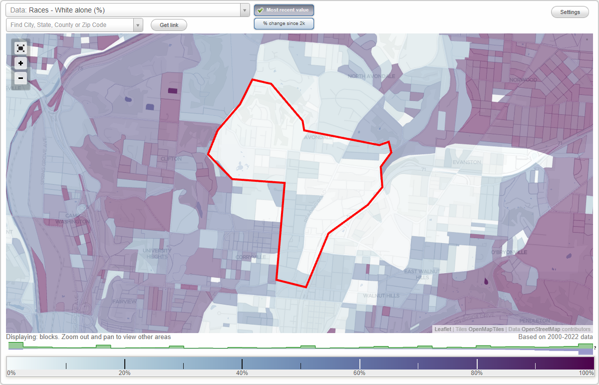
Avondale neighborhood in Cincinnati, Ohio (OH), 45217, 45219, 45220, 45229 detailed profile
Settings
X

Business Search - 14 Million verified businesses
Area: 1.407 square miles
Population: 7,799
Population density:
| Avondale: | 5,545 people per square mile |
| Cincinnati: | 3,970 people per square mile |

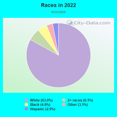
- 6,02270.0%Black
- 1,04312.1%Hispanic or Latino
- 6878.0%White
- 5596.5%Two or more races
- 1972.3%Asian
- 650.8%American Indian
- 330.4%Some other race
Distribution of median household income
![Distribution of median household income]()
- 648Less than $10,000
- 769$10,000 to $19,999
- 697$20,000 to $29,999
- 455$30,000 to $39,999
- 1,019$40,000 to $49,999
- 220$50,000 to $59,999
- 593$60,000 to $74,999
- 191$75,000 to $99,999
- 470$100,000 to $124,999
- 109$125,000 to $149,999
- 489$150,000 to $199,999
- 117$200,000 or more

Distribution of owner-occupied house/condo value
![Distribution of owner-occupied house/condo value]()
- 441Less than $50,000
- 491$50,000 to $99,999
- 569$100,000 to $149,999
- 458$150,000 to $199,999
- 656$200,000 to $249,999
- 118$250,000 to $299,999
- 324$300,000 to $399,999
- 151$400,000 to $499,999
- 244$500,000 to $749,999
- 29$750,000 to $999,999
- 237$1,000,000 or more

Distribution of rent paid by renters
![Distribution of rent paid by renters]()
- 337Less than $100
- 385$100 to $199
- 523$200 to $299
- 215$300 to $399
- 195$400 to $499
- 787$500 to $599
- 280$600 to $699
- 749$700 to $799
- 817$800 to $899
- 349$900 to $999
- 205$1,000 to $1,249
- 549$1,250 to $1,499
- 586$1,500 to $1,999
- 608$2,000 or more

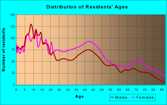
| Males: | 3,602 |
| Females: | 4,197 |
Males:
| This neighborhood: | 32.4 years |
| Whole city: | 32.7 years |
| This neighborhood: | 37.2 years |
| Whole city: | 34.2 years |
Average household size:
| Avondale: | 2.2 people |
| Cincinnati: | 23.0 people |
Percentage of family households:
| Avondale: | 40.9% |
| Cincinnati: | 33.3% |
| Here: | 25.0% |
| Cincinnati: | 23.1% |
Percentage of married-couple families with children (among all households):
| Avondale: | 13.6% |
| Cincinnati: | 22.2% |
Percentage of single-mother households (among all households):
| Avondale: | 35.6% |
| Cincinnati: | 22.0% |
Percentage of never married males 15 years old and over:
Percentage of never married females 15 years old and over:
| Avondale: | 30.9% |
| Cincinnati: | 27.2% |
Percentage of never married females 15 years old and over:
| Avondale: | 31.9% |
| city: | 29.6% |
Percentage of people that speak English not well or not at all:
| Avondale: | 0.9% |
| Cincinnati: | 1.5% |
Percentage of people born in this state:
Percentage of people born in another U.S. state:
Percentage of native residents but born outside the U.S.:
Percentage of foreign born residents:
| Here: | 74.5% |
| Cincinnati: | 69.3% |
Percentage of people born in another U.S. state:
| Avondale: | 19.1% |
| Cincinnati: | 23.5% |
Percentage of native residents but born outside the U.S.:
| Here: | 0.8% |
| city: | 1.0% |
Percentage of foreign born residents:
| Here: | 5.6% |
| Cincinnati: | 6.2% |
Owner-occupied
Renter-occupied

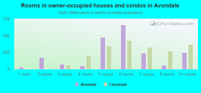
- Rooms in owner-occupied houses and condos in Avondale
- 341 room
- 1762 rooms
- 733 rooms
- 534 rooms
- 4785 rooms
- 6616 rooms
- 2407 rooms
- 618 rooms
- 2529+ rooms
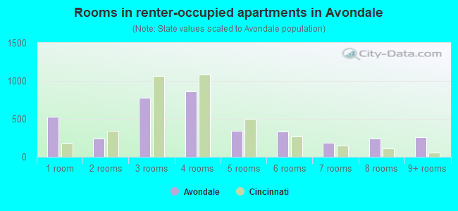
- Rooms in renter-occupied apartments in Avondale
- 5271 room
- 2432 rooms
- 7763 rooms
- 8634 rooms
- 3465 rooms
- 3306 rooms
- 1877 rooms
- 2418 rooms
- 2579+ rooms
Owner-occupied
Renter-occupied
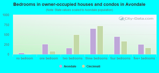
- Bedrooms in owner-occupied houses and condos in Avondale
- 34no bedroom
- 2571 bedroom
- 1602 bedrooms
- 6573 bedrooms
- 4524 bedrooms
- 2525+ bedrooms
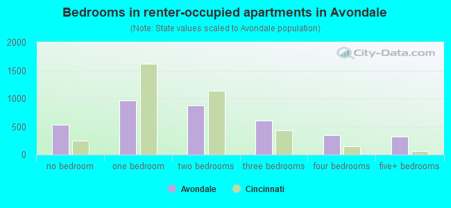
- Bedrooms in renter-occupied apartments in Avondale
- 528no bedroom
- 9651 bedroom
- 8802 bedrooms
- 6093 bedrooms
- 3514 bedrooms
- 3215+ bedrooms
Average number of cars or other vehicles available in houses/condos:
Average number of cars or other vehicles available in apartments:
| This neighborhood: | 2.1 |
| Cincinnati: | 1.9 |
Average number of cars or other vehicles available in apartments:
| Here: | 1.0 |
| city: | 1.0 |
Percentage of units with a mortgage:
| Avondale: | 72.6% |
| Cincinnati: | 67.8% |
Average estimated value of detached houses in 2022 (31.4% of all units):
| Avondale: | $225,405 |
| Ohio: | $254,366 |
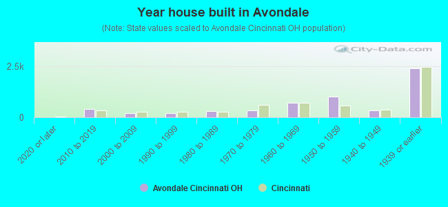
- Year house built in Avondale
- 02020 or later
- 3972010 to 2019
- 2052000 to 2009
- 2131990 to 1999
- 3151980 to 1989
- 3451970 to 1979
- 7271960 to 1969
- 1,0161950 to 1959
- 3231940 to 1949
- 2,3951939 or earlier
City-data.com crime index for city in 2020 (higher means more crime):
| City: | 490.1 |
| U.S. average: | 219.5 |
Travel time to work (commute)
![Travel time to work (commute)]()
- 186Less than 5 minutes
- 2895 to 9 minutes
- 52910 to 14 minutes
- 1,14215 to 19 minutes
- 48120 to 24 minutes
- 22125 to 29 minutes
- 14130 to 34 minutes
- 4035 to 39 minutes
- 18740 to 44 minutes
- 21145 to 59 minutes
- 26160 to 89 minutes
- 4090 or more minutes

Means of transportation to work
![Means of transportation to work]()
- 51.6%1,551Drove a car alone
- 31.6%950Carpooled
- 14.4%433Bus
- 5.6%167Taxi
- 1.7%50Bicycle
- 13.4%402Walked
- 10.1%302Other means
- 4.6%137Worked at home

Time leaving home to go to work
![Time leaving home to go to work]()
- 61612:00 a.m. to 4:59 a.m.
- 1145:00 a.m. to 5:29 a.m.
- 3375:30 a.m. to 5:59 a.m.
- 1136:00 a.m. to 6:29 a.m.
- 2526:30 a.m. to 6:59 a.m.
- 2177:00 a.m. to 7:29 a.m.
- 4867:30 a.m. to 7:59 a.m.
- 4258:00 a.m. to 8:29 a.m.
- 2378:30 a.m. to 8:59 a.m.
- 939:00 a.m. to 9:59 a.m.
- 41610:00 a.m. to 10:59 a.m.
- 1411:00 a.m. to 11:59 a.m.
- 36012:00 p.m. to 3:59 p.m.
- 2534:00 p.m. to 11:59 p.m.

Occupations of males:
- Percentage of males in management occupations (except farmers):
Here: 4.6% city: 11.2%
- Percentage of males in computer and mathematical occupations:
Here: 5.3% city: 5.4%
- Percentage of males in community and social services occupations:
Here: 6.2% city: 1.8%
- Percentage of males in education, training, and library occupations:
Here: 4.9% city: 4.4%
- Percentage of males in healthcare practitioners and technical occupations:
Here: 2.5% city: 3.6%
- Percentage of males in service occupations:
Here: 36.0% city: 14.1%
- Percentage of males in sales and office occupations:
Here: 15.4% city: 15.7%
- Percentage of males in construction, extraction, and maintenance occupations:
Here: 3.4% city: 4.4%
- Percentage of males in production occupations:
Here: 8.8% city: 6.1%
- Percentage of males in transportation occupations:
Here: 4.2% city: 4.4%
- Percentage of males in material moving occupations:
Here: 1.1% city: 8.4%
Occupations of females:
- Percentage of females in management occupations (except farmers):
Here: 13.8% city: 9.5%
- Percentage of females in business and financial operations occupations:
Here: 8.8% city: 6.1%
- Percentage of females in community and social services occupations:
Here: 1.6% city: 3.1%
- Percentage of females in education, training, and library occupations:
Here: 5.7% city: 8.4%
- Percentage of females in healthcare practitioners and technical occupations:
Here: 4.6% city: 10.6%
- Percentage of females in service occupations:
Here: 36.5% city: 20.8%
- Percentage of females in sales and office occupations:
Here: 20.9% city: 23.8%
- Percentage of females in production occupations:
Here: 6.2% city: 4.0%
Percentage of people 16-64 in Armed Forces:
| Avondale: | 0.1% |
| Cincinnati: | 0.1% |
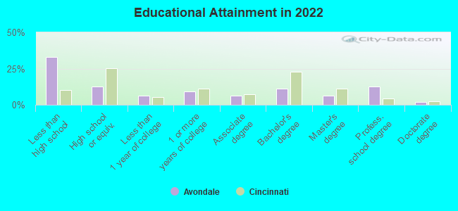
Education in this neighborhood (subdivision or community):
- Percentage of people 3 years and older in K-12 schools:
Avondale: 45.2% Cincinnati: 15.0%
- Percentage of people 3 years and older in undergraduate colleges:
Avondale: 9.0% Cincinnati: 10.0%
- Percentage of people 3 years and older in grad. or professional schools:
Avondale: 4.6% Cincinnati: 3.0%
- Percentage of students K-12 enrolled in private schools:
Avondale: 49.2% Cincinnati: 25.7%
Percentage of population below poverty level:
| Avondale: | 36.4% |
| Cincinnati: | 26.6% |
Percentage of married-couple families with both working:
| Avondale: | 82.2% |
| Cincinnati: | 77.0% |
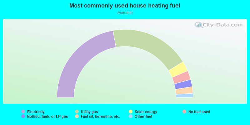
- 44.4%Electricity
- 38.1%Utility gas
- 4.8%Solar energy
- 4.3%No fuel used
- 3.4%Bottled, tank, or LP gas
- 3.2%Fuel oil, kerosene, etc.
- 1.9%Other fuel
Limited-access highways (interstate or state) in this neighborhood:
I- 71
Length: 1.19 miles
Direction: SW-NE
Direction: SW-NE
Highways in this neighborhood:
US Hwy 42 (Reading Rd)
Length: 1.52 miles
Directions: N-S, SW-NE
Address range: 2652 to 3599
Directions: N-S, SW-NE
Address range: 2652 to 3599
Roads and streets:
Forest Ave
Length: 1.45 miles
Directions: E-W, SE-NW
Address range: 15 to 699
Directions: E-W, SE-NW
Address range: 15 to 699
Rockdale Ave
Length: 1.44 miles
Directions: E-W, SE-NW
Address range: 200 to 999
Directions: E-W, SE-NW
Address range: 200 to 999
Ridgeway Ave
Length: 0.96 miles
Directions: E-W, N-S, SW-NE
Address range: 500 to 3499
Directions: E-W, N-S, SW-NE
Address range: 500 to 3499
Blair Ave
Length: 0.78 miles
Directions: E-W, SE-NW
Address range: 500 to 961
Directions: E-W, SE-NW
Address range: 500 to 961
Harvey Ave
Length: 0.77 miles
Direction: N-S
Address range: 3100 to 3525
Direction: N-S
Address range: 3100 to 3525
Wilson Ave
Length: 0.55 miles
Directions: N-S, SE-NW
Address range: 3400 to 3699
Directions: N-S, SE-NW
Address range: 3400 to 3699
Lexington Ave
Length: 0.54 miles
Direction: E-W
Address range: 800 to 971
Direction: E-W
Address range: 800 to 971
Erkenbrecher Ave
Length: 0.53 miles
Direction: E-W
Address range: 200 to 499
Direction: E-W
Address range: 200 to 499
Cleveland Ave
Length: 0.51 miles
Directions: E-W, SW-NE
Address range: 800 to 999
Directions: E-W, SW-NE
Address range: 800 to 999
Glenwood Ave
Length: 0.51 miles
Directions: N-S, SE-NW
Address range: 145 to 1099
Directions: N-S, SE-NW
Address range: 145 to 1099
Martin Luther King Dr E
Length: 0.50 miles
Direction: E-W
Address range: 422 to 599
Direction: E-W
Address range: 422 to 599
Baxter Ave
Length: 0.49 miles
Directions: E-W, SE-NW
Address range: 200 to 299
Directions: E-W, SE-NW
Address range: 200 to 299
Ehrman Ave
Length: 0.48 miles
Directions: E-W, SE-NW
Address range: 26 to 299
Directions: E-W, SE-NW
Address range: 26 to 299
Maple Ave
Length: 0.47 miles
Directions: E-W, N-S, SE-NW
Address range: 400 to 699
Directions: E-W, N-S, SE-NW
Address range: 400 to 699
Hutchins Ave
Length: 0.44 miles
Directions: E-W, SE-NW
Address range: 800 to 899
Directions: E-W, SE-NW
Address range: 800 to 899
Windham Ave
Length: 0.43 miles
Directions: E-W, SE-NW, SW-NE
Address range: 800 to 899
Directions: E-W, SE-NW, SW-NE
Address range: 800 to 899
Whittier St
Length: 0.42 miles
Directions: E-W, SW-NE
Address range: 700 to 899
Directions: E-W, SW-NE
Address range: 700 to 899
Prospect Pl
Length: 0.42 miles
Direction: E-W
Address range: 500 to 699
Direction: E-W
Address range: 500 to 699
Hickory St
Length: 0.39 miles
Direction: E-W
Address range: 400 to 599
Direction: E-W
Address range: 400 to 599
Hearne Ave
Length: 0.38 miles
Direction: E-W
Address range: 200 to 399
Direction: E-W
Address range: 200 to 399
Northern Ave
Length: 0.38 miles
Direction: E-W
Address range: 200 to 399
Direction: E-W
Address range: 200 to 399
Vernon Pl
Length: 0.37 miles
Directions: E-W, N-S, SW-NE
Address range: 2800 to 3099
Directions: E-W, N-S, SW-NE
Address range: 2800 to 3099
Alaska Ave
Length: 0.33 miles
Directions: N-S, SW-NE
Address range: 3500 to 3699
Directions: N-S, SW-NE
Address range: 3500 to 3699
Hale Ave
Length: 0.32 miles
Direction: E-W
Address range: 500 to 599
Direction: E-W
Address range: 500 to 599
Dellway St
Length: 0.31 miles
Directions: E-W, SE-NW
Address range: 800 to 899
Directions: E-W, SE-NW
Address range: 800 to 899
Dury Ave
Length: 0.30 miles
Directions: N-S, SE-NW
Address range: 3400 to 3599
Directions: N-S, SE-NW
Address range: 3400 to 3599
Burnet Ave
Length: 0.30 miles
Direction: N-S
Address range: 3400 to 3599
Direction: N-S
Address range: 3400 to 3599
Oak St
Length: 0.30 miles
Directions: E-W, SE-NW
Address range: 500 to 673
Directions: E-W, SE-NW
Address range: 500 to 673
Walls St
Length: 0.27 miles
Directions: N-S, SW-NE
Address range: 3700 to 3899
Directions: N-S, SW-NE
Address range: 3700 to 3899
Carplin Pl
Length: 0.24 miles
Direction: E-W
Address range: 500 to 599
Direction: E-W
Address range: 500 to 599
Forest Park Dr
Length: 0.23 miles
Directions: E-W, N-S, SW-NE
Address range: 3600 to 7798
Directions: E-W, N-S, SW-NE
Address range: 3600 to 7798
Winslow Ave
Length: 0.22 miles
Direction: N-S
Address range: 2800 to 2899
Direction: N-S
Address range: 2800 to 2899
Canyon Dr
Length: 0.21 miles
Directions: N-S, SW-NE
Address range: 3600 to 3699
Directions: N-S, SW-NE
Address range: 3600 to 3699
Melish Pl
Length: 0.21 miles
Directions: E-W, SE-NW
Address range: 600 to 799
Directions: E-W, SE-NW
Address range: 600 to 799
Blair Ct
Length: 0.21 miles
Direction: E-W
Address range: 900 to 1081
Direction: E-W
Address range: 900 to 1081
Vine St
Length: 0.21 miles
Directions: E-W, SE-NW
Address range: 3425 to 3514
Directions: E-W, SE-NW
Address range: 3425 to 3514
Victory Pkwy
Length: 0.20 miles
Directions: N-S, SE-NW, SW-NE
Address range: 3300 to 3509
Directions: N-S, SE-NW, SW-NE
Address range: 3300 to 3509
Haven St
Length: 0.20 miles
Direction: N-S
Address range: 3541 to 3599
Direction: N-S
Address range: 3541 to 3599
Lincoln Ave
Length: 0.20 miles
Direction: E-W
Address range: 600 to 699
Direction: E-W
Address range: 600 to 699
Fredonia Ave
Length: 0.19 miles
Directions: N-S, SE-NW
Address range: 3140 to 3299
Directions: N-S, SE-NW
Address range: 3140 to 3299
Bonfield Dr
Length: 0.19 miles
Directions: E-W, N-S, SE-NW
Address range: 3700 to 3799
Directions: E-W, N-S, SE-NW
Address range: 3700 to 3799
Beldare Ave
Length: 0.19 miles
Direction: N-S
Address range: 2 to 3599
Direction: N-S
Address range: 2 to 3599
Melbourne St
Length: 0.18 miles
Direction: E-W
Address range: 800 to 899
Direction: E-W
Address range: 800 to 899
Lossing St
Length: 0.18 miles
Directions: N-S, SW-NE
Address range: 3500 to 3599
Directions: N-S, SW-NE
Address range: 3500 to 3599
Glenmann Ln
Length: 0.18 miles
Directions: E-W, SE-NW
Directions: E-W, SE-NW
E University Ave
Length: 0.18 miles
Direction: E-W
Address range: 500 to 599
Direction: E-W
Address range: 500 to 599
Hickman Ave
Length: 0.18 miles
Direction: E-W
Address range: 500 to 599
Direction: E-W
Address range: 500 to 599
Norwich Ln
Length: 0.17 miles
Directions: N-S, SE-NW
Address range: 3601 to 3799
Directions: N-S, SE-NW
Address range: 3601 to 3799
Glenridge Pl
Length: 0.16 miles
Directions: N-S, SE-NW, SW-NE
Address range: 100 to 199
Directions: N-S, SE-NW, SW-NE
Address range: 100 to 199
Van Buren Ave
Length: 0.16 miles
Directions: N-S, SW-NE
Address range: 3100 to 3199
Directions: N-S, SW-NE
Address range: 3100 to 3199
Hallwood Pl
Length: 0.16 miles
Directions: N-S, SE-NW
Address range: 3400 to 3499
Directions: N-S, SE-NW
Address range: 3400 to 3499
Dick St
Length: 0.16 miles
Direction: N-S
Address range: 3500 to 3599
Direction: N-S
Address range: 3500 to 3599
Eden Ave
Length: 0.16 miles
Direction: N-S
Address range: 329 to 3599
Direction: N-S
Address range: 329 to 3599
Purdue St
Length: 0.16 miles
Direction: N-S
Address range: 3500 to 3599
Direction: N-S
Address range: 3500 to 3599
Tallant Ave
Length: 0.15 miles
Direction: E-W
Address range: 100 to 199
Direction: E-W
Address range: 100 to 199
Linton St
Length: 0.15 miles
Direction: E-W
Address range: 500 to 599
Direction: E-W
Address range: 500 to 599
Knott St
Length: 0.15 miles
Direction: N-S
Address range: 3400 to 3499
Direction: N-S
Address range: 3400 to 3499
Mann Pl
Length: 0.14 miles
Direction: E-W
Address range: 800 to 899
Direction: E-W
Address range: 800 to 899
Stewart Pl
Length: 0.13 miles
Directions: E-W, N-S, SE-NW, SW-NE
Address range: 500 to 599
Directions: E-W, N-S, SE-NW, SW-NE
Address range: 500 to 599
Union St
Length: 0.13 miles
Direction: E-W
Address range: 500 to 699
Direction: E-W
Address range: 500 to 699
Bathgate St
Length: 0.12 miles
Direction: N-S
Address range: 3000 to 3099
Direction: N-S
Address range: 3000 to 3099
Concordia St
Length: 0.12 miles
Direction: N-S
Address range: 3000 to 3099
Direction: N-S
Address range: 3000 to 3099
Irving St
Length: 0.12 miles
Directions: E-W, N-S, SW-NE
Address range: 3500 to 3699
Directions: E-W, N-S, SW-NE
Address range: 3500 to 3699
Dunkirk St
Length: 0.12 miles
Directions: N-S, SW-NE
Address range: 3600 to 3799
Directions: N-S, SW-NE
Address range: 3600 to 3799
Larona Ave
Length: 0.11 miles
Direction: N-S
Address range: 3400 to 3499
Direction: N-S
Address range: 3400 to 3499
Maxwell Ave
Length: 0.11 miles
Direction: E-W
Address range: 500 to 599
Direction: E-W
Address range: 500 to 599
Van Antwerp Pl
Length: 0.10 miles
Direction: N-S
Address range: 3500 to 3573
Direction: N-S
Address range: 3500 to 3573
Jay St
Length: 0.10 miles
Directions: N-S, SE-NW
Address range: 3400 to 3499
Directions: N-S, SE-NW
Address range: 3400 to 3499
Goss Rd
Length: 0.09 miles
Directions: E-W, SW-NE
Address range: 900 to 999
Directions: E-W, SW-NE
Address range: 900 to 999
Perkins Ave
Length: 0.09 miles
Direction: N-S
Address range: 3300 to 3399
Direction: N-S
Address range: 3300 to 3399
Glen Este Pl
Length: 0.09 miles
Direction: E-W
Address range: 19 to 99
Direction: E-W
Address range: 19 to 99
Drexel Pl
Length: 0.08 miles
Direction: N-S
Address range: 3300 to 3399
Direction: N-S
Address range: 3300 to 3399
Shirley Dr
Length: 0.08 miles
Direction: E-W
Address range: 2 to 99
Direction: E-W
Address range: 2 to 99
Hartford St
Length: 0.08 miles
Direction: N-S
Address range: 3400 to 3499
Direction: N-S
Address range: 3400 to 3499
Washington Ave
Length: 0.08 miles
Direction: N-S
Address range: 3500 to 3533
Direction: N-S
Address range: 3500 to 3533
Lee Pl
Length: 0.08 miles
Direction: E-W
Address range: 3500 to 3599
Direction: E-W
Address range: 3500 to 3599
Savoy Pl
Length: 0.08 miles
Direction: N-S
Address range: 3100 to 3199
Direction: N-S
Address range: 3100 to 3199
Tacoma Ave
Length: 0.08 miles
Directions: N-S, SE-NW, SW-NE
Directions: N-S, SE-NW, SW-NE
Irving Ave
Length: 0.08 miles
Directions: N-S, SE-NW
Address range: 3538 to 3699
Directions: N-S, SE-NW
Address range: 3538 to 3699
Norwich Ave
Length: 0.07 miles
Directions: N-S, SW-NE
Address range: 3600 to 3699
Directions: N-S, SW-NE
Address range: 3600 to 3699
Van Antwerp Ct
Length: 0.07 miles
Direction: E-W
Address range: 600 to 699
Direction: E-W
Address range: 600 to 699
Bowman Ter
Length: 0.07 miles
Directions: E-W, N-S, SW-NE
Address range: 1 to 99
Directions: E-W, N-S, SW-NE
Address range: 1 to 99
Duluth Ave
Length: 0.07 miles
Direction: N-S
Address range: 3600 to 3699
Direction: N-S
Address range: 3600 to 3699
Landon Ct
Length: 0.07 miles
Directions: E-W, N-S, SW-NE
Address range: 1 to 99
Directions: E-W, N-S, SW-NE
Address range: 1 to 99
Magill Ave
Length: 0.06 miles
Direction: N-S
Address range: 3500 to 3599
Direction: N-S
Address range: 3500 to 3599
Malin St
Length: 0.06 miles
Direction: N-S
Address range: 3000 to 3099
Direction: N-S
Address range: 3000 to 3099
Tower St
Length: 0.06 miles
Direction: E-W
Address range: 44 to 99
Direction: E-W
Address range: 44 to 99
Irwin Pl
Length: 0.06 miles
Direction: E-W
Address range: 200 to 299
Direction: E-W
Address range: 200 to 299
Borrman Ave
Length: 0.06 miles
Direction: N-S
Address range: 3100 to 3199
Direction: N-S
Address range: 3100 to 3199
Randolph St
Length: 0.06 miles
Direction: N-S
Direction: N-S
Estes Pl
Length: 0.05 miles
Direction: N-S
Address range: 3500 to 3599
Direction: N-S
Address range: 3500 to 3599
June St
Length: 0.05 miles
Direction: E-W
Address range: 485 to 599
Direction: E-W
Address range: 485 to 599
Bartle Ave
Length: 0.05 miles
Direction: N-S
Address range: 3000 to 3099
Direction: N-S
Address range: 3000 to 3099
Wehrman Ave
Length: 0.05 miles
Direction: N-S
Address range: 700 to 799
Direction: N-S
Address range: 700 to 799
Omaha St
Length: 0.05 miles
Direction: E-W
Direction: E-W
Tennis Ln
Length: 0.05 miles
Direction: E-W
Address range: 600 to 651
Direction: E-W
Address range: 600 to 651
Helen M Glassmeyer Ln
Length: 0.04 miles
Direction: SW-NE
Address range: 100 to 199
Direction: SW-NE
Address range: 100 to 199
Bogart Ave
Length: 0.04 miles
Direction: N-S
Address range: 3500 to 3585
Direction: N-S
Address range: 3500 to 3585
Alameda Pl
Length: 0.04 miles
Direction: N-S
Address range: 500 to 599
Direction: N-S
Address range: 500 to 599
Cleveland Ct
Length: 0.04 miles
Direction: N-S
Address range: 3400 to 3499
Direction: N-S
Address range: 3400 to 3499
William H Taft Rd
Length: 0.04 miles
Direction: E-W
Address range: 600 to 607
Direction: E-W
Address range: 600 to 607
Bonneview Ln
Length: 0.03 miles
Direction: E-W
Address range: 92 to 100
Direction: E-W
Address range: 92 to 100
Essex Pl
Length: 0.03 miles
Direction: N-S
Address range: 2636 to 2699
Direction: N-S
Address range: 2636 to 2699
Holcroft St
Length: 0.03 miles
Direction: N-S
Direction: N-S
Milton Ct
Length: 0.03 miles
Direction: N-S
Address range: 3300 to 3419
Direction: N-S
Address range: 3300 to 3419
Bonnecamp St
Length: 0.03 miles
Direction: N-S
Direction: N-S
Edmunds St
Length: 0.02 miles
Direction: N-S
Direction: N-S
Railroad features:
Conrail RR
Length: 0.77 miles
Directions: E-W, N-S, SW-NE
Directions: E-W, N-S, SW-NE