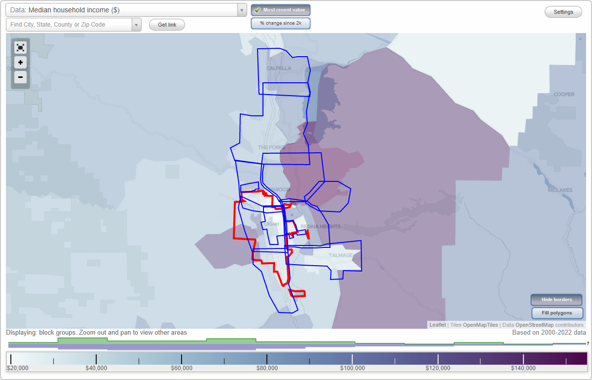
Ukiah, California Neighborhood Map - Income, House Prices, Occupations, Boundaries
Settings
X

- City boundary
- Neighborhood boundaries
Business Search - 14 Million verified businesses
Neighborhoods:
Alexander Estates, Asylum, Calpella, Central Ukiah, Downtown Ukiah, North Ukiah, Oak Manor, Presswood, Regina Heights, Talmage, The Forks, Vichy SpringsAlexander Estates neighborhood in Ukiah statistics: (Find on map)
Area: 0.187 square miles
Population: 138
Population density:
Median household income in 2021:
Median rent in in 2021:
Male vs Females
Median age
Housing prices:
Average estimated value of detached houses in 2021 (59.3% of all units):
Average estimated value of mobile home in 2021 (3.4% of all units):
Most popular occupations of males: sales and office occupations (36.8%); service occupations (17.3%); construction, extraction, and maintenance occupations (14.5%); management occupations (except farmers) (11.4%); life, physical, and social science occupations (4.0%); healthcare practitioners and technical occupations (2.8%); business and financial operations occupations (2.4%)
Most popular occupations of females: sales and office occupations (46.1%); service occupations (23.6%); management occupations (except farmers) (21.7%); business and financial operations occupations (5.6%); community and social services occupations (1.9%); education, training, and library occupations (1.9%)
Roads and streets: Feed Lot Rd; Lovers Ln; Zinfandel Dr; Chablis Dr; Malaga Dr; Tokay Ave (Tokay Ln); Despina Dr (Despina Ln); Carrigan Ln; Chablis Ct; Alicante Ln; Gamay Pl; Sirah Ct; Concord St; Burgundy Dr; N Bush St; Tanya Ln; Chardonnay Ct; Sauterne Pl; Riesling Ct; George Pl; Sauvignon Ct; Cabernet Pl.
Alexander Estates neighborhood detailed profile
Area: 0.187 square miles
Population: 138
Population density:
| Alexander Estates: | 736 people per square mile |
| Ukiah: | 3,535 people per square mile |
Median household income in 2021:
| Alexander Estates: | $54,970 |
| Ukiah: | $56,975 |
Median rent in in 2021:
| Alexander Estates: | $1,074 |
| Ukiah: | $1,076 |
Male vs Females
| Males: | 81 |
| Females: | 57 |
Median age
| Males: | 35.0 years |
| Females: | 35.6 years |
Housing prices:
Average estimated value of detached houses in 2021 (59.3% of all units):
| Alexander Estates: | $445,147 |
| California: | $881,672 |
Average estimated value of mobile home in 2021 (3.4% of all units):
| Alexander Estates: | $346,818 |
| California: | $174,181 |
Most popular occupations of males: sales and office occupations (36.8%); service occupations (17.3%); construction, extraction, and maintenance occupations (14.5%); management occupations (except farmers) (11.4%); life, physical, and social science occupations (4.0%); healthcare practitioners and technical occupations (2.8%); business and financial operations occupations (2.4%)
Most popular occupations of females: sales and office occupations (46.1%); service occupations (23.6%); management occupations (except farmers) (21.7%); business and financial operations occupations (5.6%); community and social services occupations (1.9%); education, training, and library occupations (1.9%)
Roads and streets: Feed Lot Rd; Lovers Ln; Zinfandel Dr; Chablis Dr; Malaga Dr; Tokay Ave (Tokay Ln); Despina Dr (Despina Ln); Carrigan Ln; Chablis Ct; Alicante Ln; Gamay Pl; Sirah Ct; Concord St; Burgundy Dr; N Bush St; Tanya Ln; Chardonnay Ct; Sauterne Pl; Riesling Ct; George Pl; Sauvignon Ct; Cabernet Pl.
Alexander Estates neighborhood detailed profile
Asylum neighborhood in Ukiah statistics: (Find on map)
Area: 2.409 square miles
Population: 2,518
Population density:
Median household income in 2021:
Median rent in in 2021:
Male vs Females
Median age
Housing prices:
Average estimated value of detached houses in 2021 (36.6% of all units):
Average estimated value of townhouses or other attached units in 2021 (28.6% of all units):
Average estimated value of mobile home in 2021 (21.8% of all units):
Most popular occupations of males: service occupations (18.6%); sales and office occupations (12.6%); production occupations (11.8%); transportation occupations (10.7%); construction, extraction, and maintenance occupations (10.4%); material moving occupations (9.2%); management occupations (except farmers) (5.3%)
Most popular occupations of females: service occupations (57.3%); sales and office occupations (24.1%); healthcare practitioners and technical occupations (6.8%); education, training, and library occupations (3.2%); farming, fishing, and forestry occupations (2.9%); production occupations (2.7%); management occupations (except farmers) (2.6%)
Highways in this neighborhood: Redwood Hwy (US Hwy 101); Boonville Ukiah Rd (State Rte 253, Boonville Rd).
Roads and streets: S State St; Talmage Rd; S Dora St; Airport Rd; Taylor Dr; Washington Ave; Beacon Ln; Laws Ave; Helen Ave; Blue Bonnet Dr; Hastings Rd (Hastings Frontage Rd); Stipp Ln; Fircrest Dr; Oak Court Rd; Norgard Ln; Plant Rd; Leland Ln; Zaina Ln; San Jacinta Dr (San Jacinto Dr); Jefferson Ln; Tedford Ave; Doolan Canyon Dr; Fairview Ct; Wabash Ave; Gobalet Ln; Oak Knoll Rd; Hastings Ave (Old County Rd); Toyon Rd; Oak Knoll (Oak Knoll Rd); Laurel Ave; Meadowbrook Dr (Meadowbrook Ln); Crestview Dr; Canyon Dr; N Court Rd; Nokomis Dr; Redwood Ave; Faull Ave; Whitmore Ln; Bourbon Ln; Rose Ave; Yokayo Dr; Marwen Dr; Lewis Ln; Rosemary Ln; Thompson Ave; Cresta Dr; Poulos Ct; Townsend Ln; Observatory Ave; Wabash (Wabash Ave); Pomo Ln; Valley View Rd; Donna Dr; Adams St; Yokayo Ct; Monroe St; Baywood Ct; Doolan Dr; Richard Ct; Beacon Way; Berkeley Way; Ranee Ln; Foothill Ct; Canyon View Ct; Washington Ct; Bethal Ln; Spanish Canyon Dr; Beacon Dr (Beacon Ln); Mulberry St; Nehoc Ct; Briggs Ln; Cunningham St.
Railroad features: Northwestern Pacific RR.
Other features: Doolin Crk.
Asylum neighborhood detailed profile
Area: 2.409 square miles
Population: 2,518
Population density:
| Asylum: | 1,045 people per square mile |
| Ukiah: | 3,535 people per square mile |
Median household income in 2021:
| Asylum: | $57,163 |
| Ukiah: | $56,975 |
Median rent in in 2021:
| Asylum: | $964 |
| Ukiah: | $1,076 |
Male vs Females
| Males: | 1,201 |
| Females: | 1,317 |
Median age
| Males: | 40.7 years |
| Females: | 40.8 years |
Housing prices:
Average estimated value of detached houses in 2021 (36.6% of all units):
| Asylum: | $1,126,683 |
| California: | $881,672 |
Average estimated value of townhouses or other attached units in 2021 (28.6% of all units):
| This neighborhood: | $465,000 |
| California: | $745,373 |
Average estimated value of mobile home in 2021 (21.8% of all units):
| Asylum: | $17,605,763 |
| California: | $174,181 |
Most popular occupations of males: service occupations (18.6%); sales and office occupations (12.6%); production occupations (11.8%); transportation occupations (10.7%); construction, extraction, and maintenance occupations (10.4%); material moving occupations (9.2%); management occupations (except farmers) (5.3%)
Most popular occupations of females: service occupations (57.3%); sales and office occupations (24.1%); healthcare practitioners and technical occupations (6.8%); education, training, and library occupations (3.2%); farming, fishing, and forestry occupations (2.9%); production occupations (2.7%); management occupations (except farmers) (2.6%)
Highways in this neighborhood: Redwood Hwy (US Hwy 101); Boonville Ukiah Rd (State Rte 253, Boonville Rd).
Roads and streets: S State St; Talmage Rd; S Dora St; Airport Rd; Taylor Dr; Washington Ave; Beacon Ln; Laws Ave; Helen Ave; Blue Bonnet Dr; Hastings Rd (Hastings Frontage Rd); Stipp Ln; Fircrest Dr; Oak Court Rd; Norgard Ln; Plant Rd; Leland Ln; Zaina Ln; San Jacinta Dr (San Jacinto Dr); Jefferson Ln; Tedford Ave; Doolan Canyon Dr; Fairview Ct; Wabash Ave; Gobalet Ln; Oak Knoll Rd; Hastings Ave (Old County Rd); Toyon Rd; Oak Knoll (Oak Knoll Rd); Laurel Ave; Meadowbrook Dr (Meadowbrook Ln); Crestview Dr; Canyon Dr; N Court Rd; Nokomis Dr; Redwood Ave; Faull Ave; Whitmore Ln; Bourbon Ln; Rose Ave; Yokayo Dr; Marwen Dr; Lewis Ln; Rosemary Ln; Thompson Ave; Cresta Dr; Poulos Ct; Townsend Ln; Observatory Ave; Wabash (Wabash Ave); Pomo Ln; Valley View Rd; Donna Dr; Adams St; Yokayo Ct; Monroe St; Baywood Ct; Doolan Dr; Richard Ct; Beacon Way; Berkeley Way; Ranee Ln; Foothill Ct; Canyon View Ct; Washington Ct; Bethal Ln; Spanish Canyon Dr; Beacon Dr (Beacon Ln); Mulberry St; Nehoc Ct; Briggs Ln; Cunningham St.
Railroad features: Northwestern Pacific RR.
Other features: Doolin Crk.
Asylum neighborhood detailed profile
Calpella neighborhood in Ukiah statistics: (Find on map)
Area: 3.031 square miles
Population: 636
Population density:
Median household income in 2021:
Median rent in in 2021:
Male vs Females
Median age
Housing prices:
Average estimated value of detached houses in 2021 (60.0% of all units):
Average estimated value of mobile home in 2021 (30.8% of all units):
Most popular occupations of males: farming, fishing, and forestry occupations (28.9%); production occupations (18.4%); construction, extraction, and maintenance occupations (18.2%); service occupations (15.1%); sales and office occupations (7.8%); transportation occupations (4.2%); management occupations (except farmers) (1.7%)
Most popular occupations of females: sales and office occupations (46.9%); service occupations (26.4%); healthcare practitioners and technical occupations (12.5%); education, training, and library occupations (4.9%); management occupations (except farmers) (2.9%); material moving occupations (2.7%); production occupations (1.9%)
Highways in this neighborhood: State Rte 20; Redwood Hwy (US Hwy 101).
Roads and streets: Central Ave (Frontage Rd); N State St; Eastside Calpella Rd; Marina Dr; Durable Mill Rd; Lake Ridge Rd; Gold Gulch Rd; Moore St; Black Oak Dr; Cortina Pl; Drive; Graziano Ln; 3rd St; Hopkins St; Agnes Ln; Delores Ln; Facklam Ct; Rd 144; E Calpella Rd.
Railroad features: Northwestern Pacific RR.
Other features: Russian Riv.
Calpella neighborhood detailed profile
Area: 3.031 square miles
Population: 636
Population density:
| Calpella: | 210 people per square mile |
| Ukiah: | 3,535 people per square mile |
Median household income in 2021:
| Calpella: | $61,444 |
| Ukiah: | $56,975 |
Median rent in in 2021:
| Calpella: | $922 |
| Ukiah: | $1,076 |
Male vs Females
| Males: | 337 |
| Females: | 299 |
Median age
| Males: | 45.3 years |
| Females: | 43.0 years |
Housing prices:
Average estimated value of detached houses in 2021 (60.0% of all units):
| Calpella: | $457,084 |
| California: | $881,672 |
Average estimated value of mobile home in 2021 (30.8% of all units):
| Calpella: | $89,204 |
| California: | $174,181 |
Most popular occupations of males: farming, fishing, and forestry occupations (28.9%); production occupations (18.4%); construction, extraction, and maintenance occupations (18.2%); service occupations (15.1%); sales and office occupations (7.8%); transportation occupations (4.2%); management occupations (except farmers) (1.7%)
Most popular occupations of females: sales and office occupations (46.9%); service occupations (26.4%); healthcare practitioners and technical occupations (12.5%); education, training, and library occupations (4.9%); management occupations (except farmers) (2.9%); material moving occupations (2.7%); production occupations (1.9%)
Highways in this neighborhood: State Rte 20; Redwood Hwy (US Hwy 101).
Roads and streets: Central Ave (Frontage Rd); N State St; Eastside Calpella Rd; Marina Dr; Durable Mill Rd; Lake Ridge Rd; Gold Gulch Rd; Moore St; Black Oak Dr; Cortina Pl; Drive; Graziano Ln; 3rd St; Hopkins St; Agnes Ln; Delores Ln; Facklam Ct; Rd 144; E Calpella Rd.
Railroad features: Northwestern Pacific RR.
Other features: Russian Riv.
Calpella neighborhood detailed profile
Central Ukiah neighborhood in Ukiah statistics: (Find on map)
Area: 2.861 square miles
Population: 10,088
Population density:
Median household income in 2021:
Median rent in in 2021:
Male vs Females
Median age
Housing prices:
Average estimated value of detached houses in 2021 (59.6% of all units):
Average estimated value of townhouses or other attached units in 2021 (15.4% of all units):
Average estimated value of mobile home in 2021 (26.4% of all units):
Most popular occupations of males: sales and office occupations (24.7%); service occupations (13.5%); management occupations (except farmers) (11.9%); construction, extraction, and maintenance occupations (10.0%); production occupations (6.4%); education, training, and library occupations (5.6%); transportation occupations (4.7%)
Most popular occupations of females: service occupations (31.3%); sales and office occupations (25.3%); management occupations (except farmers) (12.6%); healthcare practitioners and technical occupations (9.0%); education, training, and library occupations (8.5%); material moving occupations (2.9%); farming, fishing, and forestry occupations (2.4%)
Highways in this neighborhood: Redwood Hwy (US Hwy 101).
Roads and streets: S State St; Low Gap Rd; Talmage Rd; W Standley St; E Gobbi St; S Orchard Ave; N State St; S Dora St; N Orchard Ave; Mendocino Dr; W Perkins St; W Church St; W Clay St; Maple Ave; W Mill St; Leslie St; E Perkins St; N Bush St; S Oak St; N Oak St; Clara Ave; Ford St; Luce Ave; W Smith St; W Stephenson St; Brush St; Walnut Ave; W Gobbi St; Park Blvd; Waugh Ln; Cypress Ave; Grove Ave; Jones St; Observatory Ave; S Spring St; N Spring St; S Main St; Betty St; Dora Ave; N Pine St; Live Oak Ave; Lorraine St; N School St; Mason St; Hospital Dr; Banker Blvd; W Henry St; Helen Ave; N Dora St; Cochrane Ave; Hazel Ave; Highland Ave (S Highland Ave); S School St; Mendocino Pl; Valley View Dr; Mulberry St; Cherry St; Hillview Ave; Seminary Ave; N Main St; Marlene St; Gibson St; McPeak St; E Clay St; S Barnes St; Alice Ave; Scott St; Cindee Dr; Thomas St; Fairway Ave; Warren Dr; Peach St; Hillcrest Ave; Norton St; Highland Ct; Stella Dr; Willow Ave; Highland Dr; Clubhouse Dr; E Smith St; Freitas Ave; Lewis Ln; Gardens Ave; Lookout Dr; E Standley St; Orr St; Cooper Ln; Court St; Oak Park Ave; Rupe St; Marshall St; N Barnes St; Calvert Dr; Thompson St; Cleveland Ln; Holden St; Jackson Ave; S Hope St; S Hortense St; Giorno Ave; S Bush St; S Pine St; Observatory (Observatory Ave); W Standley Ct; Mill Ct; Evans St; Porzio Ln; Calvert Ct; Pomolita Dr; N Hortense St; Cunningham St; Myszka Pl; Plum St; Perry St; Pine St; Sidnie Ct; S Highland Ave; Barbara St; Apple Ave; Joseph St; Myron St; Park Pl; Sidnie St; Robinson Ln; Carolyn St; Henderson Ln; Todd Rd; Kings Ct; Dominican Way; N Hope St; Cherry Ct; Hamilton St; el Rio Ct; Eastlick St; E Mill St; Myrtle Ln; St Francis Ct (St Francis Way); Pomolita Way; E Stephenson St; Dalton Dr; Ruddock Ave; Myron Pl; Mary Ln; Morris St; Park Ct; Snuffin St; South St; E Church St; South Ave; Nokomis Dr; Terrace Dr; Albright Pl; Marwen Dr; Despina Dr (Despina Ln); Clay Pl; N Highland Ave; Mae St; Pomeroy St; Plum Dr; Nehoc Ct; Deborah Ct; Olga Pl; Louise Ct; River St; Biltmore St; Hurlie Dr.
Railroad features: Northwestern Pacific RR.
Other features: Orrs Crk; Doolin Crk; Gibson Crk.
Central Ukiah neighborhood detailed profile
Area: 2.861 square miles
Population: 10,088
Population density:
| Central Ukiah: | 3,526 people per square mile |
| Ukiah: | 3,535 people per square mile |
Median household income in 2021:
| Central Ukiah: | $58,673 |
| Ukiah: | $56,975 |
Median rent in in 2021:
| Central Ukiah: | $1,182 |
| Ukiah: | $1,076 |
Male vs Females
| Males: | 5,115 |
| Females: | 4,972 |
Median age
| Males: | 40.3 years |
| Females: | 44.6 years |
Housing prices:
Average estimated value of detached houses in 2021 (59.6% of all units):
| Central Ukiah: | $613,559 |
| California: | $881,672 |
Average estimated value of townhouses or other attached units in 2021 (15.4% of all units):
| This neighborhood: | $461,549 |
| California: | $745,373 |
Average estimated value of mobile home in 2021 (26.4% of all units):
| Central Ukiah: | $112,792 |
| California: | $174,181 |
Most popular occupations of males: sales and office occupations (24.7%); service occupations (13.5%); management occupations (except farmers) (11.9%); construction, extraction, and maintenance occupations (10.0%); production occupations (6.4%); education, training, and library occupations (5.6%); transportation occupations (4.7%)
Most popular occupations of females: service occupations (31.3%); sales and office occupations (25.3%); management occupations (except farmers) (12.6%); healthcare practitioners and technical occupations (9.0%); education, training, and library occupations (8.5%); material moving occupations (2.9%); farming, fishing, and forestry occupations (2.4%)
Highways in this neighborhood: Redwood Hwy (US Hwy 101).
Roads and streets: S State St; Low Gap Rd; Talmage Rd; W Standley St; E Gobbi St; S Orchard Ave; N State St; S Dora St; N Orchard Ave; Mendocino Dr; W Perkins St; W Church St; W Clay St; Maple Ave; W Mill St; Leslie St; E Perkins St; N Bush St; S Oak St; N Oak St; Clara Ave; Ford St; Luce Ave; W Smith St; W Stephenson St; Brush St; Walnut Ave; W Gobbi St; Park Blvd; Waugh Ln; Cypress Ave; Grove Ave; Jones St; Observatory Ave; S Spring St; N Spring St; S Main St; Betty St; Dora Ave; N Pine St; Live Oak Ave; Lorraine St; N School St; Mason St; Hospital Dr; Banker Blvd; W Henry St; Helen Ave; N Dora St; Cochrane Ave; Hazel Ave; Highland Ave (S Highland Ave); S School St; Mendocino Pl; Valley View Dr; Mulberry St; Cherry St; Hillview Ave; Seminary Ave; N Main St; Marlene St; Gibson St; McPeak St; E Clay St; S Barnes St; Alice Ave; Scott St; Cindee Dr; Thomas St; Fairway Ave; Warren Dr; Peach St; Hillcrest Ave; Norton St; Highland Ct; Stella Dr; Willow Ave; Highland Dr; Clubhouse Dr; E Smith St; Freitas Ave; Lewis Ln; Gardens Ave; Lookout Dr; E Standley St; Orr St; Cooper Ln; Court St; Oak Park Ave; Rupe St; Marshall St; N Barnes St; Calvert Dr; Thompson St; Cleveland Ln; Holden St; Jackson Ave; S Hope St; S Hortense St; Giorno Ave; S Bush St; S Pine St; Observatory (Observatory Ave); W Standley Ct; Mill Ct; Evans St; Porzio Ln; Calvert Ct; Pomolita Dr; N Hortense St; Cunningham St; Myszka Pl; Plum St; Perry St; Pine St; Sidnie Ct; S Highland Ave; Barbara St; Apple Ave; Joseph St; Myron St; Park Pl; Sidnie St; Robinson Ln; Carolyn St; Henderson Ln; Todd Rd; Kings Ct; Dominican Way; N Hope St; Cherry Ct; Hamilton St; el Rio Ct; Eastlick St; E Mill St; Myrtle Ln; St Francis Ct (St Francis Way); Pomolita Way; E Stephenson St; Dalton Dr; Ruddock Ave; Myron Pl; Mary Ln; Morris St; Park Ct; Snuffin St; South St; E Church St; South Ave; Nokomis Dr; Terrace Dr; Albright Pl; Marwen Dr; Despina Dr (Despina Ln); Clay Pl; N Highland Ave; Mae St; Pomeroy St; Plum Dr; Nehoc Ct; Deborah Ct; Olga Pl; Louise Ct; River St; Biltmore St; Hurlie Dr.
Railroad features: Northwestern Pacific RR.
Other features: Orrs Crk; Doolin Crk; Gibson Crk.
Central Ukiah neighborhood detailed profile
Downtown Ukiah neighborhood in Ukiah statistics: (Find on map)
Area: 0.934 square miles
Population: 3,942
Population density:
Median household income in 2021:
Median rent in in 2021:
Male vs Females
Median age
Housing prices:
Average estimated value of detached houses in 2021 (30.3% of all units):
Average estimated value of townhouses or other attached units in 2021 (12.2% of all units):
Average estimated value of mobile home in 2021 (23.1% of all units):
Most popular occupations of males: sales and office occupations (31.3%); service occupations (23.3%); construction, extraction, and maintenance occupations (15.9%); production occupations (9.3%); management occupations (except farmers) (4.5%); legal occupations (4.1%); computer and mathematical occupations (2.3%)
Most popular occupations of females: sales and office occupations (30.1%); service occupations (25.1%); healthcare practitioners and technical occupations (16.0%); farming, fishing, and forestry occupations (10.5%); life, physical, and social science occupations (8.5%); management occupations (except farmers) (5.7%); education, training, and library occupations (1.1%)
Highways in this neighborhood: Redwood Hwy (US Hwy 101).
Roads and streets: S State St; N State St; E Gobbi St; N Orchard Ave; S Orchard Ave; Leslie St; E Perkins St; S Oak St; N Oak St; Clara Ave; Ford St; Brush St; Low Gap Rd; S Main St; N School St; Mason St; Hospital Dr; W Henry St; W Church St; W Perkins St; W Standley St; W Smith St; W Clay St; W Stephenson St; S School St; Cherry St; Seminary Ave; N Main St; E Clay St; W Gobbi St; Warren Dr; Gibson St; Peach St; Norton St; Stella Dr; E Smith St; E Standley St; Scott St; Orr St; Marshall St; Cleveland Ln; S Dora St; S Bush St; S Pine St; N Dora St; N Bush St; N Pine St; Evans St; W Mill St; Porzio Ln; Plum St; Sidnie Ct; Apple Ave; Joseph St; Myron St; Sidnie St; Freitas Ave; Kings Ct; Cherry Ct; Hamilton St; E Mill St; E Stephenson St; Ruddock Ave; Myron Pl; E Church St; Pomeroy St; Plum Dr; Olga Pl; Robinson Ln; Biltmore St; Hurlie Dr; Dalton Dr.
Railroad features: Northwestern Pacific RR.
Other features: Orrs Crk; Gibson Crk.
Downtown Ukiah neighborhood detailed profile
Area: 0.934 square miles
Population: 3,942
Population density:
| Downtown Ukiah (Downtown): | 4,219 people per square mile |
| Ukiah: | 3,535 people per square mile |
Median household income in 2021:
| Downtown Ukiah (Downtown): | $52,971 |
| Ukiah: | $56,975 |
Median rent in in 2021:
| Downtown Ukiah (Downtown): | $966 |
| Ukiah: | $1,076 |
Male vs Females
| Males: | 1,997 |
| Females: | 1,944 |
Median age
| Males: | 43.9 years |
| Females: | 50.6 years |
Housing prices:
Average estimated value of detached houses in 2021 (30.3% of all units):
| Downtown Ukiah (Downtown): | $421,686 |
| California: | $881,672 |
Average estimated value of townhouses or other attached units in 2021 (12.2% of all units):
| This neighborhood: | $461,549 |
| California: | $745,373 |
Average estimated value of mobile home in 2021 (23.1% of all units):
| Downtown Ukiah (Downtown): | $112,792 |
| California: | $174,181 |
Most popular occupations of males: sales and office occupations (31.3%); service occupations (23.3%); construction, extraction, and maintenance occupations (15.9%); production occupations (9.3%); management occupations (except farmers) (4.5%); legal occupations (4.1%); computer and mathematical occupations (2.3%)
Most popular occupations of females: sales and office occupations (30.1%); service occupations (25.1%); healthcare practitioners and technical occupations (16.0%); farming, fishing, and forestry occupations (10.5%); life, physical, and social science occupations (8.5%); management occupations (except farmers) (5.7%); education, training, and library occupations (1.1%)
Highways in this neighborhood: Redwood Hwy (US Hwy 101).
Roads and streets: S State St; N State St; E Gobbi St; N Orchard Ave; S Orchard Ave; Leslie St; E Perkins St; S Oak St; N Oak St; Clara Ave; Ford St; Brush St; Low Gap Rd; S Main St; N School St; Mason St; Hospital Dr; W Henry St; W Church St; W Perkins St; W Standley St; W Smith St; W Clay St; W Stephenson St; S School St; Cherry St; Seminary Ave; N Main St; E Clay St; W Gobbi St; Warren Dr; Gibson St; Peach St; Norton St; Stella Dr; E Smith St; E Standley St; Scott St; Orr St; Marshall St; Cleveland Ln; S Dora St; S Bush St; S Pine St; N Dora St; N Bush St; N Pine St; Evans St; W Mill St; Porzio Ln; Plum St; Sidnie Ct; Apple Ave; Joseph St; Myron St; Sidnie St; Freitas Ave; Kings Ct; Cherry Ct; Hamilton St; E Mill St; E Stephenson St; Ruddock Ave; Myron Pl; E Church St; Pomeroy St; Plum Dr; Olga Pl; Robinson Ln; Biltmore St; Hurlie Dr; Dalton Dr.
Railroad features: Northwestern Pacific RR.
Other features: Orrs Crk; Gibson Crk.
Downtown Ukiah neighborhood detailed profile
North Ukiah neighborhood in Ukiah statistics: (Find on map)
Area: 2.180 square miles
Population: 1,697
Population density:
Median household income in 2021:
Median rent in in 2021:
Male vs Females
Median age
Housing prices:
Average estimated value of detached houses in 2021 (64.8% of all units):
Average estimated value of mobile home in 2021 (8.5% of all units):
Most popular occupations of males: sales and office occupations (31.3%); service occupations (15.9%); management occupations (except farmers) (13.6%); construction, extraction, and maintenance occupations (13.5%); education, training, and library occupations (4.4%); life, physical, and social science occupations (3.5%); transportation occupations (2.8%)
Most popular occupations of females: sales and office occupations (38.7%); service occupations (31.2%); management occupations (except farmers) (17.2%); education, training, and library occupations (6.8%); business and financial operations occupations (4.0%); material moving occupations (1.0%)
Highways in this neighborhood: Redwood Hwy (US Hwy 101).
Roads and streets: Lovers Ln; N State St; Low Gap Rd; Feed Lot Rd; Orr Springs Rd; N Bush St; Pinoleville Dr (Pinoleville Rd); Empire Dr (S Empire Dr); Despina Dr (Despina Ln); Ford St; Elm St; Zinfandel Dr; Brush St; Briggs St; Carrigan Ln; Capps Ln; Chablis Dr; Ford Rd; Brunner St; N Oak St; Lockwood Dr; Garrett Dr; Malaga Dr; Tokay Ave (Tokay Ln); N Lovers Ln; Orr St; Gibson St; Sherry Dr; Magnolia St; Mazzoni St; Arlington Dr; Irvington Dr; N Pine St; Donner Ln; Burlington Dr; Millview Rd; Carleton Dr; N Orchard Ave; Kuki Rd; Evans St; Chablis Ct; Incline Dr; Pine St; Alicante Ln; Wellmar Dr; Sidnie Ct; Pond Dr (Pinoleville Rd); Gamay Pl; Industry Rd; Homewood Dr; Sirah Ct; Concord St; Bricarelli Dr; Burgundy Dr; Kuki Ln (Kuki Rd); Tanya Ln; Donner Ct; Myron Pl; Chardonnay Ct; Sauterne Pl; Riesling Ct; Tahoe Ct; Masonite Rd; Chrystal Bay Ct (Crystal Bay Ct); George Pl; River St; Incline Ct; Summit Ct; Zephyr Ct (Zephyr Cove Ct); Sauvignon Ct.
Railroad features: Northwestern Pacific RR.
Other features: Orrs Crk; Ackerman Crk.
North Ukiah neighborhood detailed profile
Area: 2.180 square miles
Population: 1,697
Population density:
| North Ukiah: | 779 people per square mile |
| Ukiah: | 3,535 people per square mile |
Median household income in 2021:
| North Ukiah: | $54,211 |
| Ukiah: | $56,975 |
Median rent in in 2021:
| North Ukiah: | $1,066 |
| Ukiah: | $1,076 |
Male vs Females
| Males: | 1,005 |
| Females: | 692 |
Median age
| Males: | 39.5 years |
| Females: | 37.8 years |
Housing prices:
Average estimated value of detached houses in 2021 (64.8% of all units):
| North Ukiah: | $475,370 |
| California: | $881,672 |
Average estimated value of mobile home in 2021 (8.5% of all units):
| North Ukiah: | $196,094 |
| California: | $174,181 |
Most popular occupations of males: sales and office occupations (31.3%); service occupations (15.9%); management occupations (except farmers) (13.6%); construction, extraction, and maintenance occupations (13.5%); education, training, and library occupations (4.4%); life, physical, and social science occupations (3.5%); transportation occupations (2.8%)
Most popular occupations of females: sales and office occupations (38.7%); service occupations (31.2%); management occupations (except farmers) (17.2%); education, training, and library occupations (6.8%); business and financial operations occupations (4.0%); material moving occupations (1.0%)
Highways in this neighborhood: Redwood Hwy (US Hwy 101).
Roads and streets: Lovers Ln; N State St; Low Gap Rd; Feed Lot Rd; Orr Springs Rd; N Bush St; Pinoleville Dr (Pinoleville Rd); Empire Dr (S Empire Dr); Despina Dr (Despina Ln); Ford St; Elm St; Zinfandel Dr; Brush St; Briggs St; Carrigan Ln; Capps Ln; Chablis Dr; Ford Rd; Brunner St; N Oak St; Lockwood Dr; Garrett Dr; Malaga Dr; Tokay Ave (Tokay Ln); N Lovers Ln; Orr St; Gibson St; Sherry Dr; Magnolia St; Mazzoni St; Arlington Dr; Irvington Dr; N Pine St; Donner Ln; Burlington Dr; Millview Rd; Carleton Dr; N Orchard Ave; Kuki Rd; Evans St; Chablis Ct; Incline Dr; Pine St; Alicante Ln; Wellmar Dr; Sidnie Ct; Pond Dr (Pinoleville Rd); Gamay Pl; Industry Rd; Homewood Dr; Sirah Ct; Concord St; Bricarelli Dr; Burgundy Dr; Kuki Ln (Kuki Rd); Tanya Ln; Donner Ct; Myron Pl; Chardonnay Ct; Sauterne Pl; Riesling Ct; Tahoe Ct; Masonite Rd; Chrystal Bay Ct (Crystal Bay Ct); George Pl; River St; Incline Ct; Summit Ct; Zephyr Ct (Zephyr Cove Ct); Sauvignon Ct.
Railroad features: Northwestern Pacific RR.
Other features: Orrs Crk; Ackerman Crk.
North Ukiah neighborhood detailed profile
Oak Manor neighborhood in Ukiah statistics: (Find on map)
Area: 0.283 square miles
Population: 56
Population density:
Median household income in 2021:
Median rent in in 2021:
Male vs Females
Median age
Housing prices:
Average estimated value of detached houses in 2021 (69.0% of all units):
Average estimated value of townhouses or other attached units in 2021 (55.2% of all units):
Most popular occupations of males: sales and office occupations (18.2%); farming, fishing, and forestry occupations (17.8%); healthcare practitioners and technical occupations (9.3%); management occupations (except farmers) (8.9%); community and social services occupations (8.2%); construction, extraction, and maintenance occupations (7.5%); material moving occupations (5.8%)
Most popular occupations of females: sales and office occupations (36.6%); service occupations (23.1%); material moving occupations (17.6%); healthcare practitioners and technical occupations (8.7%); management occupations (except farmers) (8.3%); life, physical, and social science occupations (3.0%); business and financial operations occupations (2.4%)
Highways in this neighborhood: Redwood Hwy (US Hwy 101).
Roads and streets: E Gobbi St; Oak Manor Dr; Washo Dr; Yosemite Dr; Pomo Dr; E Perkins St; Club House Dr; el Rio St; Mohawk Dr; Pomo Way; Vichy Springs Rd; River Rd (Babcock Ln); Yaqui Dr; Maya Way; Oak Manor Ct; Wiyat Dr; el Rio Ct.
Other features: Gibson Crk.
Oak Manor neighborhood detailed profile
Area: 0.283 square miles
Population: 56
Population density:
| Oak Manor: | 198 people per square mile |
| Ukiah: | 3,535 people per square mile |
Median household income in 2021:
| Oak Manor: | $53,330 |
| Ukiah: | $56,975 |
Median rent in in 2021:
| Oak Manor: | $1,305 |
| Ukiah: | $1,076 |
Male vs Females
| Males: | 24 |
| Females: | 32 |
Median age
| Males: | 55.8 years |
| Females: | 51.1 years |
Housing prices:
Average estimated value of detached houses in 2021 (69.0% of all units):
| Oak Manor: | $464,388 |
| California: | $881,672 |
Average estimated value of townhouses or other attached units in 2021 (55.2% of all units):
| This neighborhood: | $465,000 |
| California: | $745,373 |
Most popular occupations of males: sales and office occupations (18.2%); farming, fishing, and forestry occupations (17.8%); healthcare practitioners and technical occupations (9.3%); management occupations (except farmers) (8.9%); community and social services occupations (8.2%); construction, extraction, and maintenance occupations (7.5%); material moving occupations (5.8%)
Most popular occupations of females: sales and office occupations (36.6%); service occupations (23.1%); material moving occupations (17.6%); healthcare practitioners and technical occupations (8.7%); management occupations (except farmers) (8.3%); life, physical, and social science occupations (3.0%); business and financial operations occupations (2.4%)
Highways in this neighborhood: Redwood Hwy (US Hwy 101).
Roads and streets: E Gobbi St; Oak Manor Dr; Washo Dr; Yosemite Dr; Pomo Dr; E Perkins St; Club House Dr; el Rio St; Mohawk Dr; Pomo Way; Vichy Springs Rd; River Rd (Babcock Ln); Yaqui Dr; Maya Way; Oak Manor Ct; Wiyat Dr; el Rio Ct.
Other features: Gibson Crk.
Oak Manor neighborhood detailed profile
Presswood neighborhood in Ukiah statistics: (Find on map)
Area: 3.727 square miles
Population: 1,491
Population density:
Median household income in 2021:
Median rent in in 2021:
Male vs Females
Median age
Housing prices:
Average estimated value of detached houses in 2021 (71.1% of all units):
Average estimated value of mobile home in 2021 (19.3% of all units):
Most popular occupations of males: sales and office occupations (23.7%); construction, extraction, and maintenance occupations (18.4%); service occupations (15.8%); management occupations (except farmers) (11.6%); healthcare practitioners and technical occupations (8.3%); life, physical, and social science occupations (4.2%); education, training, and library occupations (3.4%)
Most popular occupations of females: sales and office occupations (35.2%); service occupations (20.4%); management occupations (except farmers) (18.3%); business and financial operations occupations (8.7%); life, physical, and social science occupations (4.2%); construction, extraction, and maintenance occupations (2.4%); community and social services occupations (2.1%)
Highways in this neighborhood: Redwood Hwy (US Hwy 101).
Roads and streets: Hollow Tree Rd; N State St; Redemeyer Rd; Deerwood Dr; Wildwood Rd; Ford Rd; Hollow Tree Creek Rd; Hulda Dr; Fawnwood Dr; Lewis Ln; Ridgeview Dr; Vista Verde Rd; el Dorado Rd; Meadow Dr; Arroyo Rd; Sequoia Plz; Ellis Ln; Antler Rd; Olive Ln; Orr Springs Rd; Chateau Pl; Hensley Creek Rd; Tan Oak Pl; Pg & E Rd; Masonite Industrial Rd; Fawn Pl; Christopher Ct; Sierra Pl; Masonite Rd; Mosswood Rd; Orive Way; Pinoleville Dr (Pinoleville Rd); Park Terrace Ct; Hollowtree Rd; Tan Oak Dr.
Railroad features: Northwestern Pacific RR.
Other features: Howard Crk; Ackerman Crk; Russian Riv.
Presswood neighborhood detailed profile
Area: 3.727 square miles
Population: 1,491
Population density:
| Presswood: | 400 people per square mile |
| Ukiah: | 3,535 people per square mile |
Median household income in 2021:
| Presswood: | $67,300 |
| Ukiah: | $56,975 |
Median rent in in 2021:
| Presswood: | $880 |
| Ukiah: | $1,076 |
Male vs Females
| Males: | 780 |
| Females: | 711 |
Median age
| Males: | 42.6 years |
| Females: | 36.2 years |
Housing prices:
Average estimated value of detached houses in 2021 (71.1% of all units):
| Presswood: | $535,144 |
| California: | $881,672 |
Average estimated value of mobile home in 2021 (19.3% of all units):
| Presswood: | $180,179 |
| California: | $174,181 |
Most popular occupations of males: sales and office occupations (23.7%); construction, extraction, and maintenance occupations (18.4%); service occupations (15.8%); management occupations (except farmers) (11.6%); healthcare practitioners and technical occupations (8.3%); life, physical, and social science occupations (4.2%); education, training, and library occupations (3.4%)
Most popular occupations of females: sales and office occupations (35.2%); service occupations (20.4%); management occupations (except farmers) (18.3%); business and financial operations occupations (8.7%); life, physical, and social science occupations (4.2%); construction, extraction, and maintenance occupations (2.4%); community and social services occupations (2.1%)
Highways in this neighborhood: Redwood Hwy (US Hwy 101).
Roads and streets: Hollow Tree Rd; N State St; Redemeyer Rd; Deerwood Dr; Wildwood Rd; Ford Rd; Hollow Tree Creek Rd; Hulda Dr; Fawnwood Dr; Lewis Ln; Ridgeview Dr; Vista Verde Rd; el Dorado Rd; Meadow Dr; Arroyo Rd; Sequoia Plz; Ellis Ln; Antler Rd; Olive Ln; Orr Springs Rd; Chateau Pl; Hensley Creek Rd; Tan Oak Pl; Pg & E Rd; Masonite Industrial Rd; Fawn Pl; Christopher Ct; Sierra Pl; Masonite Rd; Mosswood Rd; Orive Way; Pinoleville Dr (Pinoleville Rd); Park Terrace Ct; Hollowtree Rd; Tan Oak Dr.
Railroad features: Northwestern Pacific RR.
Other features: Howard Crk; Ackerman Crk; Russian Riv.
Presswood neighborhood detailed profile
Regina Heights neighborhood in Ukiah statistics: (Find on map)
Area: 2.722 square miles
Population: 805
Population density:
Median household income in 2021:
Median rent in in 2021:
Male vs Females
Median age
Housing prices:
Average estimated value of detached houses in 2021 (77.1% of all units):
Average estimated value of townhouses or other attached units in 2021 (5.5% of all units):
Average estimated value of mobile home in 2021 (2.9% of all units):
Most popular occupations of males: sales and office occupations (22.0%); management occupations (except farmers) (17.2%); production occupations (12.3%); material moving occupations (8.4%); arts, design, entertainment, sports, and media occupations (8.0%); healthcare practitioners and technical occupations (7.9%); construction, extraction, and maintenance occupations (5.7%)
Most popular occupations of females: sales and office occupations (51.4%); service occupations (10.9%); community and social services occupations (8.6%); management occupations (except farmers) (8.1%); material moving occupations (7.4%); healthcare practitioners and technical occupations (5.0%); business and financial operations occupations (2.1%)
Highways in this neighborhood: Redwood Hwy (US Hwy 101).
Roads and streets: Vichy Springs Rd; Watson Rd; E Gobbi St; Ridge Rd; Vichy Hills Dr; Quail Dr; Recreation Rd; Sanford Ranch Rd; Oak Manor Dr; Knob Hill Rd; View Dr; Van Pelt Dr; Washo Dr; Yosemite Dr; Linda Vista Dr; Pomo Dr; E Perkins St; Glenwood Dr; Madrone Ave; River Rd (Babcock Ln); Club House Dr; James St; el Rio St; Crane Ter; Fir Terrace Dr; Mohawk Dr; Crane Rd; Pomo Way; Sunset Dr; Manzanita Dr; Woodland Ter; Yaqui Dr; River St; Maya Way; Oak Manor Ct; Isola Way; Riverwell St; Wiyat Dr; Redemeyer Rd; el Rio Ct; Hickory Ct; Myrtle Ln; E Madrone Ave; Barringer Rd; City Well Rd; Acorn Way.
Other features: Russian Riv; Sulphur Crk; Orrs Crk; Doolin Crk; Gibson Crk.
Regina Heights neighborhood detailed profile
Area: 2.722 square miles
Population: 805
Population density:
| Regina Heights (Regina): | 296 people per square mile |
| Ukiah: | 3,535 people per square mile |
Median household income in 2021:
| Regina Heights (Regina): | $69,779 |
| Ukiah: | $56,975 |
Median rent in in 2021:
| Regina Heights (Regina): | $1,182 |
| Ukiah: | $1,076 |
Male vs Females
| Males: | 356 |
| Females: | 448 |
Median age
| Males: | 45.8 years |
| Females: | 39.7 years |
Housing prices:
Average estimated value of detached houses in 2021 (77.1% of all units):
| Regina Heights (Regina): | $469,253 |
| California: | $881,672 |
Average estimated value of townhouses or other attached units in 2021 (5.5% of all units):
| This neighborhood: | $465,000 |
| California: | $745,373 |
Average estimated value of mobile home in 2021 (2.9% of all units):
| Regina Heights (Regina): | $378,102 |
| California: | $174,181 |
Most popular occupations of males: sales and office occupations (22.0%); management occupations (except farmers) (17.2%); production occupations (12.3%); material moving occupations (8.4%); arts, design, entertainment, sports, and media occupations (8.0%); healthcare practitioners and technical occupations (7.9%); construction, extraction, and maintenance occupations (5.7%)
Most popular occupations of females: sales and office occupations (51.4%); service occupations (10.9%); community and social services occupations (8.6%); management occupations (except farmers) (8.1%); material moving occupations (7.4%); healthcare practitioners and technical occupations (5.0%); business and financial operations occupations (2.1%)
Highways in this neighborhood: Redwood Hwy (US Hwy 101).
Roads and streets: Vichy Springs Rd; Watson Rd; E Gobbi St; Ridge Rd; Vichy Hills Dr; Quail Dr; Recreation Rd; Sanford Ranch Rd; Oak Manor Dr; Knob Hill Rd; View Dr; Van Pelt Dr; Washo Dr; Yosemite Dr; Linda Vista Dr; Pomo Dr; E Perkins St; Glenwood Dr; Madrone Ave; River Rd (Babcock Ln); Club House Dr; James St; el Rio St; Crane Ter; Fir Terrace Dr; Mohawk Dr; Crane Rd; Pomo Way; Sunset Dr; Manzanita Dr; Woodland Ter; Yaqui Dr; River St; Maya Way; Oak Manor Ct; Isola Way; Riverwell St; Wiyat Dr; Redemeyer Rd; el Rio Ct; Hickory Ct; Myrtle Ln; E Madrone Ave; Barringer Rd; City Well Rd; Acorn Way.
Other features: Russian Riv; Sulphur Crk; Orrs Crk; Doolin Crk; Gibson Crk.
Regina Heights neighborhood detailed profile
Talmage neighborhood in Ukiah statistics: (Find on map)
Area: 2.648 square miles
Population: 1,117
Population density:
Median household income in 2021:
Median rent in in 2021:
Male vs Females
Median age
Housing prices:
Average estimated value of detached houses in 2021 (48.4% of all units):
Average estimated value of townhouses or other attached units in 2021 (4.1% of all units):
Average estimated value of mobile home in 2021 (21.3% of all units):
Most popular occupations of males: production occupations (20.4%); community and social services occupations (19.1%); healthcare practitioners and technical occupations (14.3%); construction, extraction, and maintenance occupations (10.8%); architecture and engineering occupations (8.9%); service occupations (7.6%); sales and office occupations (5.0%)
Most popular occupations of females: sales and office occupations (34.9%); service occupations (32.5%); education, training, and library occupations (10.3%); community and social services occupations (9.2%); material moving occupations (7.8%); management occupations (except farmers) (1.7%); healthcare practitioners and technical occupations (1.6%)
Highways in this neighborhood: Redwood Hwy (US Hwy 101).
Roads and streets: Caldwell Frontage Rd (Talmage Rd); Mill Creek Rd; Tindall Ranch Rd; Sanford Ranch Rd; Eastside Rd; Guidiville Rancheria Rd (Guidiville Reservation Rd); McClure Subdivision Rd; Hastings Rd (Hastings Frontage Rd); Addor; Hops Estate Ln; Ruddick Cunningham Rd; Kindmess Ave; Talmage Ct; Budhi; Twining Rd; Bodmi Way; Peterson Ln; Mendo Wine County Rd; Proper Work Ave; Eunice Ct; Foster Ln; Broggie Ln; Mendocino Rd; Proper Vw; West St; Gibson Ln; Proper Thought; Guidiville Rd; Myrtle Ln; Mindfulness Ave; Glenrob Ave; Burke Rd; Frontage Rd; Bartolomei Rd; Giving Way; Guidiville Reservation Rd.
Other features: Mill Crk; Mc Clure Crk; North Frk; Doolin Crk; Russian Riv.
Talmage neighborhood detailed profile
Area: 2.648 square miles
Population: 1,117
Population density:
| Talmage: | 422 people per square mile |
| Ukiah: | 3,535 people per square mile |
Median household income in 2021:
| Talmage: | $58,904 |
| Ukiah: | $56,975 |
Median rent in in 2021:
| Talmage: | $1,062 |
| Ukiah: | $1,076 |
Male vs Females
| Males: | 349 |
| Females: | 767 |
Median age
| Males: | 48.2 years |
| Females: | 45.1 years |
Housing prices:
Average estimated value of detached houses in 2021 (48.4% of all units):
| Talmage: | $446,357 |
| California: | $881,672 |
Average estimated value of townhouses or other attached units in 2021 (4.1% of all units):
| This neighborhood: | $465,000 |
| California: | $745,373 |
Average estimated value of mobile home in 2021 (21.3% of all units):
| Talmage: | $385,795 |
| California: | $174,181 |
Most popular occupations of males: production occupations (20.4%); community and social services occupations (19.1%); healthcare practitioners and technical occupations (14.3%); construction, extraction, and maintenance occupations (10.8%); architecture and engineering occupations (8.9%); service occupations (7.6%); sales and office occupations (5.0%)
Most popular occupations of females: sales and office occupations (34.9%); service occupations (32.5%); education, training, and library occupations (10.3%); community and social services occupations (9.2%); material moving occupations (7.8%); management occupations (except farmers) (1.7%); healthcare practitioners and technical occupations (1.6%)
Highways in this neighborhood: Redwood Hwy (US Hwy 101).
Roads and streets: Caldwell Frontage Rd (Talmage Rd); Mill Creek Rd; Tindall Ranch Rd; Sanford Ranch Rd; Eastside Rd; Guidiville Rancheria Rd (Guidiville Reservation Rd); McClure Subdivision Rd; Hastings Rd (Hastings Frontage Rd); Addor; Hops Estate Ln; Ruddick Cunningham Rd; Kindmess Ave; Talmage Ct; Budhi; Twining Rd; Bodmi Way; Peterson Ln; Mendo Wine County Rd; Proper Work Ave; Eunice Ct; Foster Ln; Broggie Ln; Mendocino Rd; Proper Vw; West St; Gibson Ln; Proper Thought; Guidiville Rd; Myrtle Ln; Mindfulness Ave; Glenrob Ave; Burke Rd; Frontage Rd; Bartolomei Rd; Giving Way; Guidiville Reservation Rd.
Other features: Mill Crk; Mc Clure Crk; North Frk; Doolin Crk; Russian Riv.
Talmage neighborhood detailed profile
The Forks neighborhood in Ukiah statistics: (Find on map)
Area: 6.724 square miles
Population: 3,444
Population density:
Median household income in 2021:
Median rent in in 2021:
Male vs Females
Median age
Housing prices:
Average estimated value of detached houses in 2021 (54.7% of all units):
Average estimated value of mobile home in 2021 (52.9% of all units):
Most popular occupations of males: service occupations (20.0%); construction, extraction, and maintenance occupations (16.1%); sales and office occupations (15.3%); transportation occupations (8.9%); production occupations (6.3%); management occupations (except farmers) (5.5%); farming, fishing, and forestry occupations (5.5%)
Most popular occupations of females: sales and office occupations (40.1%); service occupations (26.5%); education, training, and library occupations (8.2%); management occupations (except farmers) (6.5%); healthcare practitioners and technical occupations (5.8%); material moving occupations (4.9%); business and financial operations occupations (2.4%)
Highways in this neighborhood: Redwood Hwy (US Hwy 101).
Roads and streets: N State St; Lake Mendocino Dr; Lake Ridge Rd; Eastside Calpella Rd; Parducci Rd; E Calpella Rd (Eastside Calpella Rd); Hensley Creek Rd; Frontage Road A (W Lake Mendocino Dr); Rafello Dr; Hollow Tree Rd; Redemeyer Rd; Hulda Dr; Ben Rd; Poma Ln; Doolittle Rd; Carter Ln; Deghi Ln; Pepperwood Pl; Tollini Ln; Lorenzo Rd; Davis Dr; 1st Ave; Central Ave (Frontage Rd); Milani Dr; Gold Gulch Rd; Westerly Pl; Aldo Ln; Hulda; Rancho Grande Dr; Rio Vista Ln; Carousel Ln; Sherf Ln; Drive; Hardwick Rd; Sunnycrest Dr; Christy Ct (Christy Ln, Christy Rd); Antoni Ln (Antoni Rd); Pomo Ln; Briarwood Dr; Burnette Dr (Burnette Way); Beltrami Dr; Observation Rd; Hamby Ford Rd; Blanco Pl; Terrace Rd; Chyanna Ct; Cromwell Dr; Malaga Ct; Barnett Way; Pg & E Rd; Richey Rd; Lorenzi Rd; Cabana Ct; Bonita Pl; Elsie Way; Agnes Ln; Portlock Ln; Pallini Ln (Frontage Road A); River Ln; Chess Ln (Chess Way); Vintage Dr; W Fork Dr; Van Housen Dr; W Lake Rd; Rio Vis; Hollowtree Rd; Mendocino Dr; E Side Calpella Rd.
Railroad features: Northwestern Pacific RR.
Other features: Russian Riv; East Fork Russian Riv; Hensley Crk.
The Forks neighborhood detailed profile
Area: 6.724 square miles
Population: 3,444
Population density:
| The Forks (Forks): | 512 people per square mile |
| Ukiah: | 3,535 people per square mile |
Median household income in 2021:
| The Forks (Forks): | $68,302 |
| Ukiah: | $56,975 |
Median rent in in 2021:
| The Forks (Forks): | $874 |
| Ukiah: | $1,076 |
Male vs Females
| Males: | 1,548 |
| Females: | 1,896 |
Median age
| Males: | 45.2 years |
| Females: | 40.4 years |
Housing prices:
Average estimated value of detached houses in 2021 (54.7% of all units):
| The Forks (Forks): | $486,060 |
| California: | $881,672 |
Average estimated value of mobile home in 2021 (52.9% of all units):
| The Forks (Forks): | $89,999 |
| California: | $174,181 |
Most popular occupations of males: service occupations (20.0%); construction, extraction, and maintenance occupations (16.1%); sales and office occupations (15.3%); transportation occupations (8.9%); production occupations (6.3%); management occupations (except farmers) (5.5%); farming, fishing, and forestry occupations (5.5%)
Most popular occupations of females: sales and office occupations (40.1%); service occupations (26.5%); education, training, and library occupations (8.2%); management occupations (except farmers) (6.5%); healthcare practitioners and technical occupations (5.8%); material moving occupations (4.9%); business and financial operations occupations (2.4%)
Highways in this neighborhood: Redwood Hwy (US Hwy 101).
Roads and streets: N State St; Lake Mendocino Dr; Lake Ridge Rd; Eastside Calpella Rd; Parducci Rd; E Calpella Rd (Eastside Calpella Rd); Hensley Creek Rd; Frontage Road A (W Lake Mendocino Dr); Rafello Dr; Hollow Tree Rd; Redemeyer Rd; Hulda Dr; Ben Rd; Poma Ln; Doolittle Rd; Carter Ln; Deghi Ln; Pepperwood Pl; Tollini Ln; Lorenzo Rd; Davis Dr; 1st Ave; Central Ave (Frontage Rd); Milani Dr; Gold Gulch Rd; Westerly Pl; Aldo Ln; Hulda; Rancho Grande Dr; Rio Vista Ln; Carousel Ln; Sherf Ln; Drive; Hardwick Rd; Sunnycrest Dr; Christy Ct (Christy Ln, Christy Rd); Antoni Ln (Antoni Rd); Pomo Ln; Briarwood Dr; Burnette Dr (Burnette Way); Beltrami Dr; Observation Rd; Hamby Ford Rd; Blanco Pl; Terrace Rd; Chyanna Ct; Cromwell Dr; Malaga Ct; Barnett Way; Pg & E Rd; Richey Rd; Lorenzi Rd; Cabana Ct; Bonita Pl; Elsie Way; Agnes Ln; Portlock Ln; Pallini Ln (Frontage Road A); River Ln; Chess Ln (Chess Way); Vintage Dr; W Fork Dr; Van Housen Dr; W Lake Rd; Rio Vis; Hollowtree Rd; Mendocino Dr; E Side Calpella Rd.
Railroad features: Northwestern Pacific RR.
Other features: Russian Riv; East Fork Russian Riv; Hensley Crk.
The Forks neighborhood detailed profile
Vichy Springs neighborhood in Ukiah statistics: (Find on map)
Area: 1.507 square miles
Population: 197
Population density:
Median household income in 2021:
Median rent in in 2021:
Male vs Females
Median age
Average estimated value of detached houses in 2021 (98.7% of all units):
Most popular occupations of males: construction, extraction, and maintenance occupations (25.0%); healthcare practitioners and technical occupations (20.9%); management occupations (except farmers) (13.2%); service occupations (10.5%); education, training, and library occupations (9.5%); community and social services occupations (4.9%); transportation occupations (4.9%)
Most popular occupations of females: sales and office occupations (17.6%); business and financial operations occupations (16.1%); management occupations (except farmers) (14.5%); life, physical, and social science occupations (13.7%); service occupations (12.0%); community and social services occupations (6.3%); material moving occupations (4.9%)
Roads and streets: Vichy Springs Rd; Apolinaris Dr; Saint Yorre Ct; Tehuacan Rd; Catalan Ct; Saratoga Ct; Ardesch Ct.
Other features: Sulphur Crk.
Vichy Springs neighborhood detailed profile
Area: 1.507 square miles
Population: 197
Population density:
| Vichy Springs (Vichy): | 131 people per square mile |
| Ukiah: | 3,535 people per square mile |
Median household income in 2021:
| Vichy Springs (Vichy): | $118,661 |
| Ukiah: | $56,975 |
Median rent in in 2021:
| Vichy Springs (Vichy): | $379 |
| Ukiah: | $1,076 |
Male vs Females
| Males: | 85 |
| Females: | 111 |
Median age
| Males: | 49.8 years |
| Females: | 38.6 years |
Average estimated value of detached houses in 2021 (98.7% of all units):
| Vichy Springs (Vichy): | $605,608 |
| California: | $881,672 |
Most popular occupations of males: construction, extraction, and maintenance occupations (25.0%); healthcare practitioners and technical occupations (20.9%); management occupations (except farmers) (13.2%); service occupations (10.5%); education, training, and library occupations (9.5%); community and social services occupations (4.9%); transportation occupations (4.9%)
Most popular occupations of females: sales and office occupations (17.6%); business and financial operations occupations (16.1%); management occupations (except farmers) (14.5%); life, physical, and social science occupations (13.7%); service occupations (12.0%); community and social services occupations (6.3%); material moving occupations (4.9%)
Roads and streets: Vichy Springs Rd; Apolinaris Dr; Saint Yorre Ct; Tehuacan Rd; Catalan Ct; Saratoga Ct; Ardesch Ct.
Other features: Sulphur Crk.
Vichy Springs neighborhood detailed profile