Rialto, California Neighborhood Map - Income, House Prices, Occupations, Boundaries
Settings
X

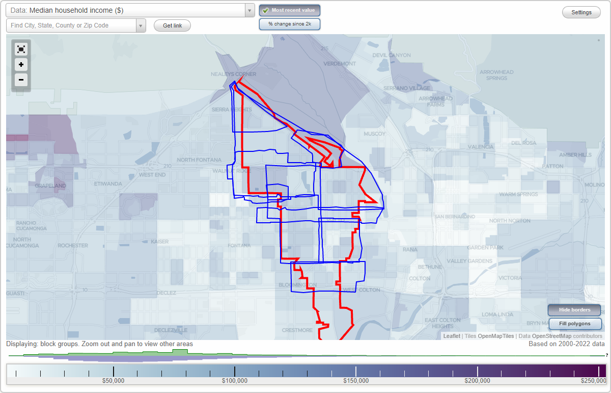
- City boundary
- Neighborhood boundaries
Business Search - 14 Million verified businesses
Neighborhoods:
Downtown, El Rancho Verde, Foothill Boulevard, I-10 Corridor, Industrial Project Area, Las Colinas, North Rialto, North Rialto Business Park, Renaissance RialtoDowntown neighborhood in Rialto statistics: (Find on map)
Area: 2.694 square miles
Population: 20,975
Population density:
Median household income in 2021:
Median rent in in 2021:
Male vs Females
Median age
Housing prices:
Average estimated value of detached houses in 2021 (58.0% of all units):
Average estimated value of townhouses or other attached units in 2021 (11.1% of all units):
Average estimated value of mobile home in 2021 (36.9% of all units):
Most popular occupations of males: service occupations (19.5%); production occupations (18.8%); material moving occupations (15.0%); construction, extraction, and maintenance occupations (12.6%); sales and office occupations (10.3%); transportation occupations (9.0%); management occupations (except farmers) (2.4%)
Most popular occupations of females: sales and office occupations (33.5%); service occupations (31.3%); management occupations (except farmers) (9.2%); material moving occupations (7.7%); education, training, and library occupations (6.7%); production occupations (5.1%); healthcare practitioners and technical occupations (3.0%)
Highways in this neighborhood: State Hwy 66 (W Foothill Blvd).
Roads and streets: S Riverside Ave; W Randall Ave; E Foothill Blvd; S Sycamore Ave; S Willow Ave; S Acacia Ave; S Lilac Ave; S Eucalyptus Ave; S Pepper Ave; E Rialto Ave; E Merrill Ave; E Wilson St; W Rialto Ave; E 3rd St; E South St; Bloomington Ave; E 2nd St; E Carter St; N Eucalyptus Ave; E Mc Kinley St; E Randall Ave; W Merrill Ave; E 1st St; S Date Ave; E James St; E Bonnie View Dr; N Riverside Ave; S Joyce Ave; N Willow Ave; N Lilac Ave; N Sycamore Ave; N Acacia Ave; N Pepper Ave; E Erwin St; S Olive Ave; S Pampas Ave; S Orange Ave; W 3rd St; E Grant St; E Fromer St; E King St; E Montrose St; S Sage Ave; N Orange Ave; N Palm Ave; N Date Ave; N Olive Ave; S Encina Ave; S Tamarisk Ave; W Orchard St; E Allen St; W Santolinas St; S Rexford St; N Magnolia Ave; W Alru St; W 1st St; S Palm Ave; W 2nd St; E Alru St; W Birch St; W Bonnie View Dr; W South St; W Atchison St; W Mill St; S Millard Ave; E Vodden St; S Clifford Ave; W Wilson St; Private Rd (S Loretta St); S Primrose Ave; S Marcella Ave; E Huff St; S Verde Ave; N Clifford Ave; S Oakdale Ave; S Magnolia Ave; S Lamarr St; E Orchard St; N Millard Ave; W Vodden St; W Oregon St; E Ceres St; Cardamon St; W Poplar Cir; S Pine Ave; W Westwind St; N Encina Ave; Holladay Pl; W Mc Kinley St; W Rosemary Ln; E Elm Ct; W Cherry St; E Glen Oak St; W Montrose St; Park Vista Dr; Jefferson Ave; N Pampas Ave; W Jefferson Ave; Chestnut Ct; W James St; W Park Vista Dr; W Fromer St; N Pine Ave; Pine Ave; N Primrose Ave; S Rosalind St; Oakhurst Dr; S Meadow View Dr; Park Haven Dr; Poplar St; S Encina Ct; W Grant St; Tamarisk Ave; S Gardena Ave; S Alice Ave; W Carter St; Roxbury Dr; Camden Dr; Pleasant Ct; N Joyce Ave; W Hollow Glen Cir; S Benjamin Ave; N Oakdale Ave; W Los Robles Ct; Bedford Dr; N Sycamore Ave S; S Benjamin St; Carter St (S Magnolia Ave); S Coriander Ave; W Poplar St; N Christobal Ln.
Railroad features: Burlington Northern Santa Fe Rlwy.
Downtown neighborhood detailed profile
Area: 2.694 square miles
Population: 20,975
Population density:
| Downtown (Central Business District): | 7,786 people per square mile |
| Rialto: | 4,773 people per square mile |
Median household income in 2021:
| Downtown (Central Business District): | $61,223 |
| Rialto: | $69,982 |
Median rent in in 2021:
| Downtown (Central Business District): | $1,067 |
| Rialto: | $1,280 |
Male vs Females
| Males: | 10,076 |
| Females: | 10,898 |
Median age
| Males: | 29.6 years |
| Females: | 32.3 years |
Housing prices:
Average estimated value of detached houses in 2021 (58.0% of all units):
| Downtown (Central Business District): | $368,093 |
| Rialto: | $341,795 |
Average estimated value of townhouses or other attached units in 2021 (11.1% of all units):
| This neighborhood: | $473,052 |
| city: | $446,493 |
Average estimated value of mobile home in 2021 (36.9% of all units):
| Downtown (Central Business District): | $28,762 |
| Rialto: | $65,996 |
Most popular occupations of males: service occupations (19.5%); production occupations (18.8%); material moving occupations (15.0%); construction, extraction, and maintenance occupations (12.6%); sales and office occupations (10.3%); transportation occupations (9.0%); management occupations (except farmers) (2.4%)
Most popular occupations of females: sales and office occupations (33.5%); service occupations (31.3%); management occupations (except farmers) (9.2%); material moving occupations (7.7%); education, training, and library occupations (6.7%); production occupations (5.1%); healthcare practitioners and technical occupations (3.0%)
Highways in this neighborhood: State Hwy 66 (W Foothill Blvd).
Roads and streets: S Riverside Ave; W Randall Ave; E Foothill Blvd; S Sycamore Ave; S Willow Ave; S Acacia Ave; S Lilac Ave; S Eucalyptus Ave; S Pepper Ave; E Rialto Ave; E Merrill Ave; E Wilson St; W Rialto Ave; E 3rd St; E South St; Bloomington Ave; E 2nd St; E Carter St; N Eucalyptus Ave; E Mc Kinley St; E Randall Ave; W Merrill Ave; E 1st St; S Date Ave; E James St; E Bonnie View Dr; N Riverside Ave; S Joyce Ave; N Willow Ave; N Lilac Ave; N Sycamore Ave; N Acacia Ave; N Pepper Ave; E Erwin St; S Olive Ave; S Pampas Ave; S Orange Ave; W 3rd St; E Grant St; E Fromer St; E King St; E Montrose St; S Sage Ave; N Orange Ave; N Palm Ave; N Date Ave; N Olive Ave; S Encina Ave; S Tamarisk Ave; W Orchard St; E Allen St; W Santolinas St; S Rexford St; N Magnolia Ave; W Alru St; W 1st St; S Palm Ave; W 2nd St; E Alru St; W Birch St; W Bonnie View Dr; W South St; W Atchison St; W Mill St; S Millard Ave; E Vodden St; S Clifford Ave; W Wilson St; Private Rd (S Loretta St); S Primrose Ave; S Marcella Ave; E Huff St; S Verde Ave; N Clifford Ave; S Oakdale Ave; S Magnolia Ave; S Lamarr St; E Orchard St; N Millard Ave; W Vodden St; W Oregon St; E Ceres St; Cardamon St; W Poplar Cir; S Pine Ave; W Westwind St; N Encina Ave; Holladay Pl; W Mc Kinley St; W Rosemary Ln; E Elm Ct; W Cherry St; E Glen Oak St; W Montrose St; Park Vista Dr; Jefferson Ave; N Pampas Ave; W Jefferson Ave; Chestnut Ct; W James St; W Park Vista Dr; W Fromer St; N Pine Ave; Pine Ave; N Primrose Ave; S Rosalind St; Oakhurst Dr; S Meadow View Dr; Park Haven Dr; Poplar St; S Encina Ct; W Grant St; Tamarisk Ave; S Gardena Ave; S Alice Ave; W Carter St; Roxbury Dr; Camden Dr; Pleasant Ct; N Joyce Ave; W Hollow Glen Cir; S Benjamin Ave; N Oakdale Ave; W Los Robles Ct; Bedford Dr; N Sycamore Ave S; S Benjamin St; Carter St (S Magnolia Ave); S Coriander Ave; W Poplar St; N Christobal Ln.
Railroad features: Burlington Northern Santa Fe Rlwy.
Downtown neighborhood detailed profile
El Rancho Verde neighborhood in Rialto statistics: (Find on map)
Area: 1.688 square miles
Highways in this neighborhood: State Hwy 30 (W Highland Ave).
Roads and streets: N Riverside Ave; Sycamore Ave; N Apple Ave; N Palm Ave; N Orange Ave; Magnolia Ave; Country Club Dr; N Sycamore Ave; Olive Ave; Geremander Ave; N Oakdale Ave; Date Ave; Riverside Oh E; E Arbeth St; E Highland Ave; N Milor Ave; E Coral Tree Dr; Cheshire St; E Galway St; Cactus Ave; Rowan Ave; Riverside Oh W; E Condor Dr; W Norwood St; Perry Ave; Willow Ave (Galway St); W Columbine Ave; N Yucca Ave; Lupin Ave; W Willow Ave; E Belmont Ave; Kauri Ave; Larch Ave; Pecan Ave; Knollwood Ave; N Magnolia Ave; Meadow Ln; W Casmalia St; Koa Dr; N Cedar Ave; Oakland Ave; N Ayala Dr; Downing Dr; W Cherry Ave; Columbine Ave; Dalewood Ave; Casmalia St; E Shamwood Ave; Cherry St; N Driftwood Ave; Peach St; N Quince Ave; E Pomegranate Ave; Winslow Ave; Lawrie Ave; N Iris Ave; W Cheshire St; Apple Ave; N Willow Ave; N Church Ave; Princeton Ct; Chelsea Ct; Quince Ave; Magnolia Ct; Lilac Ave; Orange Ave; Palm Ave; Compton Ave; N Althea Ave; N Date Ave; W Country Club Dr; N Compton Ave.
El Rancho Verde neighborhood detailed profile
Foothill Boulevard neighborhood in Rialto statistics: (Find on map)
Area: 2.562 square miles
Population: 22,007
Population density:
Median household income in 2021:
Median rent in in 2021:
Male vs Females
Median age
Housing prices:
Average estimated value of detached houses in 2021 (70.1% of all units):
Average estimated value of townhouses or other attached units in 2021 (6.0% of all units):
Average estimated value of mobile home in 2021 (21.9% of all units):
Most popular occupations of males: construction, extraction, and maintenance occupations (26.2%); material moving occupations (16.2%); sales and office occupations (14.1%); service occupations (13.0%); transportation occupations (9.0%); production occupations (6.3%); management occupations (except farmers) (3.1%)
Most popular occupations of females: service occupations (32.6%); sales and office occupations (27.0%); material moving occupations (14.5%); healthcare practitioners and technical occupations (8.1%); management occupations (except farmers) (6.5%); education, training, and library occupations (5.5%); production occupations (2.2%)
Highways in this neighborhood: W Foothill Blvd (State Hwy 66); Foothill Blvd (State Hwy 66).
Roads and streets: W Victoria St; W Grove St; W Rosewood St; E Victoria St; E Foothill Blvd; W 6th St; W Ramona Dr; W Cornell Dr; W 7th St; E Cornell Dr; W Morgan St; E Van Koevering St; Saint Elmo Dr; Barbee St; N Macy St; W Spruce St; Fairfax St; E Ramona Dr; Laurel Ave; W Van Koevering St; E Rosewood St; Alder Ave; Spruce St; Fairview Dr; N Lilac Ave; Locust Ave; N Riverside Ave; E Grove St; N Sycamore Ave; N Meridian Ave; N Willow Ave; N Pepper Ave; Grace Ave; Terry St; N Acacia Ave; N Spruce Ave; Laurel Dr; N Dallas Ave; N Cedar Ave; N Eucalyptus Ave; N Maple Ave; Vine St; N Linden Ave; E Morgan St; N Yucca Ave; N Larch Ave; N Lamarr St; W Mason St; W Cornell St; N Rosalind St; N Fillmore Ave; W 5th St; N Brierwood Ave; N Cactus Ave; Spohn Ave; Williams Rd; N Driftwood Ave; N Joyce Ave; N Aspen Ave; N Smoke Tree Ave; N Lancewood Ave; N Clifford Ave; N Verde Ave; N Marvin Dr; N Church Ave; W Cleveland St; W Barbee St; Ferndale Dr; W Vine St; Dumond Dr; Folke St; N Marcella Ave; N Sage Ave; N Oakdale Ave; N Park Ave; N Vista Ave; N Primrose Ave; W Rosemary Ln; N Millard Ave; McWethy Dr; W Court St; N Arrowhead Ave; N Idyllwild Ave; N Brampton Ave; N Glenwood Ave; N Birch Ave; N Belden Ave; Frankfort Ave; Reed St; W McWethy St; Malaga Ct; W Lorraine Pl; N Beechwood Ave; N Pampas Ave; N Burney St; N Olive Ave; N Loretta St; Malaga Dr; N Ashford Ave; N Sandalwood Ave; N Lassen Ave; N Date Ave; N San Anselmo Ave; San Benito Ave; San Carlo Ave; N Pine Ave; N Chestnut Ave; N Mulberry Ave; N Vine Ave; Cleveland St; W Victoria Ave; Dallas Ave; N Orange Ave; 6th St (E 6th St); N Quince Ave; Mikalor Ave; N Magnolia Ave; W Ramona Ct; N Sutter Ave; N Terrace Rd; W Rue Cir; W Belden Ct; N Iris Ave (Cornell Dr); N Encina Ave; N Althea Ave (Cornell Dr); Park Ave; Iris Ave; W McWethy Dr; Heidi Ct.
Railroad features: Burlington Northern Santa Fe Rlwy.
Foothill Boulevard neighborhood detailed profile
Area: 2.562 square miles
Population: 22,007
Population density:
| Foothill Boulevard (Foothill Corridor): | 8,589 people per square mile |
| Rialto: | 4,773 people per square mile |
Median household income in 2021:
| Foothill Boulevard (Foothill Corridor): | $58,536 |
| Rialto: | $69,982 |
Median rent in in 2021:
| Foothill Boulevard (Foothill Corridor): | $1,299 |
| Rialto: | $1,280 |
Male vs Females
| Males: | 11,187 |
| Females: | 10,819 |
Median age
| Males: | 27.7 years |
| Females: | 30.7 years |
Housing prices:
Average estimated value of detached houses in 2021 (70.1% of all units):
| Foothill Boulevard (Foothill Corridor): | $315,852 |
| Rialto: | $341,795 |
Average estimated value of townhouses or other attached units in 2021 (6.0% of all units):
| This neighborhood: | $473,052 |
| city: | $446,493 |
Average estimated value of mobile home in 2021 (21.9% of all units):
| Foothill Boulevard (Foothill Corridor): | $11,966 |
| Rialto: | $65,996 |
Most popular occupations of males: construction, extraction, and maintenance occupations (26.2%); material moving occupations (16.2%); sales and office occupations (14.1%); service occupations (13.0%); transportation occupations (9.0%); production occupations (6.3%); management occupations (except farmers) (3.1%)
Most popular occupations of females: service occupations (32.6%); sales and office occupations (27.0%); material moving occupations (14.5%); healthcare practitioners and technical occupations (8.1%); management occupations (except farmers) (6.5%); education, training, and library occupations (5.5%); production occupations (2.2%)
Highways in this neighborhood: W Foothill Blvd (State Hwy 66); Foothill Blvd (State Hwy 66).
Roads and streets: W Victoria St; W Grove St; W Rosewood St; E Victoria St; E Foothill Blvd; W 6th St; W Ramona Dr; W Cornell Dr; W 7th St; E Cornell Dr; W Morgan St; E Van Koevering St; Saint Elmo Dr; Barbee St; N Macy St; W Spruce St; Fairfax St; E Ramona Dr; Laurel Ave; W Van Koevering St; E Rosewood St; Alder Ave; Spruce St; Fairview Dr; N Lilac Ave; Locust Ave; N Riverside Ave; E Grove St; N Sycamore Ave; N Meridian Ave; N Willow Ave; N Pepper Ave; Grace Ave; Terry St; N Acacia Ave; N Spruce Ave; Laurel Dr; N Dallas Ave; N Cedar Ave; N Eucalyptus Ave; N Maple Ave; Vine St; N Linden Ave; E Morgan St; N Yucca Ave; N Larch Ave; N Lamarr St; W Mason St; W Cornell St; N Rosalind St; N Fillmore Ave; W 5th St; N Brierwood Ave; N Cactus Ave; Spohn Ave; Williams Rd; N Driftwood Ave; N Joyce Ave; N Aspen Ave; N Smoke Tree Ave; N Lancewood Ave; N Clifford Ave; N Verde Ave; N Marvin Dr; N Church Ave; W Cleveland St; W Barbee St; Ferndale Dr; W Vine St; Dumond Dr; Folke St; N Marcella Ave; N Sage Ave; N Oakdale Ave; N Park Ave; N Vista Ave; N Primrose Ave; W Rosemary Ln; N Millard Ave; McWethy Dr; W Court St; N Arrowhead Ave; N Idyllwild Ave; N Brampton Ave; N Glenwood Ave; N Birch Ave; N Belden Ave; Frankfort Ave; Reed St; W McWethy St; Malaga Ct; W Lorraine Pl; N Beechwood Ave; N Pampas Ave; N Burney St; N Olive Ave; N Loretta St; Malaga Dr; N Ashford Ave; N Sandalwood Ave; N Lassen Ave; N Date Ave; N San Anselmo Ave; San Benito Ave; San Carlo Ave; N Pine Ave; N Chestnut Ave; N Mulberry Ave; N Vine Ave; Cleveland St; W Victoria Ave; Dallas Ave; N Orange Ave; 6th St (E 6th St); N Quince Ave; Mikalor Ave; N Magnolia Ave; W Ramona Ct; N Sutter Ave; N Terrace Rd; W Rue Cir; W Belden Ct; N Iris Ave (Cornell Dr); N Encina Ave; N Althea Ave (Cornell Dr); Park Ave; Iris Ave; W McWethy Dr; Heidi Ct.
Railroad features: Burlington Northern Santa Fe Rlwy.
Foothill Boulevard neighborhood detailed profile
I-10 Corridor neighborhood in Rialto statistics: (Find on map)
Area: 3.168 square miles
Limited-access highways (interstate or state) in this neighborhood: I- 10 (San Bernardino Fwy).
Roads and streets: I 10 Fwy E (); W San Bernardino Ave; W Valley Blvd; Bloomington Ave; W Hawthorne St; Cedar Ave; W Woodcrest St; S Cactus Ave; S Willow Ave; S Lilac Ave; S Riverside Ave; E Valley Blvd; Larch Ave; W Granada St; N Eucalyptus Ave; Magnolia St; Valley Blvd; W Manzanita St; W Miramont St; Up Railroad Access Rd; Vine St; N Wildrose Ave; W Union Pacific Railroad Access Rd; S Althea Ave; San Bernardino Ave; W el Molino St; S Spruce Ave; W Pomona Ave; S Idyllwild Ave; N Pepper Ave; Tullock St; Grove Pl; Olive St; W Mallory Dr; Spruce Ave; W Westwind St; Marygold Ave; S Iris Ave; W Admiralty St; Pomona Ave; (Church St); S Arrowhead Ave; N Sycamore Ave S; W Grovewood St; N Cantara St; W de Carmen Dr; N Christobal Ln; S Fillmore Ave; E San Bernardino Ave; W Greenbriar St; W Buttonwood St; S Beechwood Ave; S San Dimas Ave; W Quartermaster St; Woodcrest St; W de Anza Dr; S Larch Ave; S Teakwood Ave; N Iron Horse Dr; S Yucca Ave; W Poema Dr; W Woodpine Ave; Claremont Ave; Portola Ave; W Golden Spike Dr; Alameda Ave; W Sosa Ln; N Martinez Ln; N Joshua Tree St; W Montrose St; N Indigo Ave; W Sequoia Ave; W Date Tree Rd; N Coral Tree Rd; S Alice Ave; N Runaway Cir; N Northwestern Cir; W Padilla Dr; W Orquesta Ct; N Lugo Ln; Bautista Ln; S Church Ave; Julian Ct; Bel Canto Ct; W Tullock St; S Vine Ave; Express Cir; N Rexford St; Lynwood St; S Clifford Ave; W Sago Palm Rd; W Cluster Pine Rd; W Sago Tree Rd; W Fig Tree Rd; W Bent Rail Cir; Manzanita Dr; S Sycamore Ave; S Verde Ave; Wisteria St; N Whistle Stop Dr; S Acacia Ave; N Aqua Caliente Ln; W Iron Horse Dr; S Driftwood Ave; S Park Ave; N Jacaranda Rd; Wisteria Ct; N Northstar Ave; Commercial St; Hawthorne Ave; Mallory Dr; W Station Dr; N Whiteoak Rd; N Candleberry Rd; N Satinwood Rd; N Lulitree Rd; N Cherrytree Rd; N Topsail Ave; N Driftwood Ave; N Voyager Ave; S Palm Ave; Roxbury Dr; Bloomington Ct; S Geronimo Ave; W Serenata St; N Trujillo Ln; High St; S Railroad Access Rd; S Vista Ave; W Sandalwood Rd; N Hurricane Ave; W Iron Horse Cir N; Iron Horse Cir; W Iron Horse Cir S; Woodcrest Ct; W Concepcion Dr; N San Gabriel Dr; W Railroad Access Rd; S Brampton Ave; S Glenwood Ave.
Railroad features: Union Pacific RR (Amtrak RR); Amtrak RR (Union Pacific RR).
I-10 Corridor neighborhood detailed profile
Industrial Project Area neighborhood in Rialto statistics: (Find on map)
Area: 7.002 square miles
Population: 40,496
Population density:
Median household income in 2021:
Median rent in in 2021:
Male vs Females
Median age
Average estimated value of detached houses in 2021 (96.1% of all units):
Most popular occupations of males: sales and office occupations (29.1%); construction, extraction, and maintenance occupations (17.4%); material moving occupations (10.4%); service occupations (9.8%); transportation occupations (7.7%); production occupations (7.5%); healthcare practitioners and technical occupations (6.7%)
Most popular occupations of females: sales and office occupations (39.2%); service occupations (24.7%); material moving occupations (9.2%); education, training, and library occupations (8.2%); healthcare practitioners and technical occupations (7.6%); management occupations (except farmers) (4.5%); production occupations (2.2%)
Highways in this neighborhood: State Hwy 30 (W Highland Ave); W Foothill Blvd (State Hwy 66).
Roads and streets: N Lilac Ave; N Linden Ave; N Cactus Ave; W Base Line Rd; W Randall Ave; W Etiwanda Ave; W Merrill Ave; W Easton St; N Maple Ave; N Cedar Ave; W Rialto Ave; W Grove St; W 2nd St; W Victoria St; N Idyllwild Ave; W Carter St; N Spruce Ave; N Arrowhead Ave; W Alru St; S Cactus Ave; S Linden Ave; N Fillmore Ave; N Driftwood Ave; W Rosewood St; S Maple Ave; S Cedar Ave; S Lilac Ave; N Locust Ave; N Laurel Ave; N Ayala Dr; Laurel Ave; State 210 Hwy; Locust Ave; W Pinedale Ave; N Yucca Ave; W James St; Lorraine Pl; S Larch Ave; N Teakwood Ave; W Mesa Dr; W Morgan St; N Larch Ave; N Brampton Ave; W Jackson St; W 3rd St; N Glenwood Ave; N Iris Ave; W Shamrock St; S Spruce Ave; W Van Koevering St; N Beechwood Ave; W Wabash St; W Valencia St; S Church Ave; W Orchard St; Miller Ave; W Baseline Rd; Miro Way; Williams Rd; N Park Ave; W Madrona St; W Walnut Ave; W Holly St; N Lancewood Ave; Montgomery Ave; N Brierwood Ave; N Fitzgerald Ave; N Elmwood Ave; Ramona Ave; Easton St; N Smoke Tree Ave; W Ramona Dr; N Quince Ave; N Aspen Ave; Raymond Ct; W Fontlee Ln; W Mariana St; West Virginia St; San Jacinto Ave; Barbee St; W Vodden St; W Scott St; W Huff St; N Sandalwood Ave; Yucca Ave; W Winchester Dr; S Yucca Ave; S Beechwood Ave; S Brierwood Ave; Lurelane St; W Mc Kinley St; S Idyllwild Ave; W Fromer St; S Arrowhead Ave; Grace Ave; N Wisteria Ave; S Ironwood Ave; S Sandalwood Ave; W Montrose St; W Mariposa Dr; W Wedgewood St; Fairview Dr; Walnut Ave; S Fillmore Ave; S Iris Ave; Park Ave; S Brampton Ave; N Church Ave; N Sunset Cir; S Teakwood Ave; W 1st St; Farney Ave; Arrow Blvd (W Rialto Ave); N Ashford Ave; Orange St; S Driftwood Ave; Brampton Ave; Woodhill St; Anaconda St; W Mason St; W Cornell St; N Althea Ave; S Wisteria Ave; Holladay Pl; Tahoe St; S Forest Ave; W Chaparral St; S Verde Ave; W Cornell Dr; Wilson St; W Bonnie View Dr; Montrose St; N Martin St; N Vine Ave; S Vine Ave; N Forest Ave; Grove Pl; W Heather St; W Sequoia Ave; S Aspen Ave; S Ashford Ave; Wedgewood Ct; Laguna Pl; Spohn Ave; Mesa St; S Glenwood Ave; N Brentwood Ave; Cactus Ave; Ayala Dr; N Ironwood Ave; Cromwell St; Bloomington Ave; Tibbot St; N Oakwood Ave; Jackson St; Shamrock St; S Quince Ave; Laurel Dr; W Tahoe St; Ferndale Ave; Fillmore Ave; W Home St; W Barbee St; W Wedgewood Ct; Ferndale Dr; Cedar Ave; W Durst Dr; Aspen Ave; Dumond Dr; Fairfax St; Cummings St; W Grant St; Folke St; S Smoke Tree Ave; Creighton Ct; Emanuelli Ct; W June St; Grace St; Iris Ave; Leiske Dr; Freesia Way; S Althea Ave; Terry St; Buckeye St; Althea Ave; S Geronimo Ave; W Athol St; W McWethy St; Dumond St; W Lorraine Pl; S Lancewood Ave; Aspen St; Fontlee Ln; Myles Ct; Sequoia Ave; Buckeye Ct; Chaparral St; Schallert St; Orchard St; Hollis St; Wisteria St; N Yucca St; Frankfort Ave; Buckeye Dr; S Park Ave; W Wilson Ave; Idyllwild Ave; W Cerritos St; Trudy Ave; Silver Cir; Grove Way; W Victoria Ave; Dumond Ave; N Camphor Ave; W Cascade Dr; Texas Ct; Martin Ct; W Holladay Pl; W McWethy Dr; San Jacinto Ct; Heidi Ct.
Railroad features: Burlington Northern Santa Fe Rlwy.
Industrial Project Area neighborhood detailed profile
Area: 7.002 square miles
Population: 40,496
Population density:
| Industrial Project Area: | 5,783 people per square mile |
| Rialto: | 4,773 people per square mile |
Median household income in 2021:
| Industrial Project Area: | $76,035 |
| Rialto: | $69,982 |
Median rent in in 2021:
| Industrial Project Area: | $1,260 |
| Rialto: | $1,280 |
Male vs Females
| Males: | 20,168 |
| Females: | 20,327 |
Median age
| Males: | 36.6 years |
| Females: | 36.1 years |
Average estimated value of detached houses in 2021 (96.1% of all units):
| Industrial Project Area: | $318,046 |
| Rialto: | $341,795 |
Most popular occupations of males: sales and office occupations (29.1%); construction, extraction, and maintenance occupations (17.4%); material moving occupations (10.4%); service occupations (9.8%); transportation occupations (7.7%); production occupations (7.5%); healthcare practitioners and technical occupations (6.7%)
Most popular occupations of females: sales and office occupations (39.2%); service occupations (24.7%); material moving occupations (9.2%); education, training, and library occupations (8.2%); healthcare practitioners and technical occupations (7.6%); management occupations (except farmers) (4.5%); production occupations (2.2%)
Highways in this neighborhood: State Hwy 30 (W Highland Ave); W Foothill Blvd (State Hwy 66).
Roads and streets: N Lilac Ave; N Linden Ave; N Cactus Ave; W Base Line Rd; W Randall Ave; W Etiwanda Ave; W Merrill Ave; W Easton St; N Maple Ave; N Cedar Ave; W Rialto Ave; W Grove St; W 2nd St; W Victoria St; N Idyllwild Ave; W Carter St; N Spruce Ave; N Arrowhead Ave; W Alru St; S Cactus Ave; S Linden Ave; N Fillmore Ave; N Driftwood Ave; W Rosewood St; S Maple Ave; S Cedar Ave; S Lilac Ave; N Locust Ave; N Laurel Ave; N Ayala Dr; Laurel Ave; State 210 Hwy; Locust Ave; W Pinedale Ave; N Yucca Ave; W James St; Lorraine Pl; S Larch Ave; N Teakwood Ave; W Mesa Dr; W Morgan St; N Larch Ave; N Brampton Ave; W Jackson St; W 3rd St; N Glenwood Ave; N Iris Ave; W Shamrock St; S Spruce Ave; W Van Koevering St; N Beechwood Ave; W Wabash St; W Valencia St; S Church Ave; W Orchard St; Miller Ave; W Baseline Rd; Miro Way; Williams Rd; N Park Ave; W Madrona St; W Walnut Ave; W Holly St; N Lancewood Ave; Montgomery Ave; N Brierwood Ave; N Fitzgerald Ave; N Elmwood Ave; Ramona Ave; Easton St; N Smoke Tree Ave; W Ramona Dr; N Quince Ave; N Aspen Ave; Raymond Ct; W Fontlee Ln; W Mariana St; West Virginia St; San Jacinto Ave; Barbee St; W Vodden St; W Scott St; W Huff St; N Sandalwood Ave; Yucca Ave; W Winchester Dr; S Yucca Ave; S Beechwood Ave; S Brierwood Ave; Lurelane St; W Mc Kinley St; S Idyllwild Ave; W Fromer St; S Arrowhead Ave; Grace Ave; N Wisteria Ave; S Ironwood Ave; S Sandalwood Ave; W Montrose St; W Mariposa Dr; W Wedgewood St; Fairview Dr; Walnut Ave; S Fillmore Ave; S Iris Ave; Park Ave; S Brampton Ave; N Church Ave; N Sunset Cir; S Teakwood Ave; W 1st St; Farney Ave; Arrow Blvd (W Rialto Ave); N Ashford Ave; Orange St; S Driftwood Ave; Brampton Ave; Woodhill St; Anaconda St; W Mason St; W Cornell St; N Althea Ave; S Wisteria Ave; Holladay Pl; Tahoe St; S Forest Ave; W Chaparral St; S Verde Ave; W Cornell Dr; Wilson St; W Bonnie View Dr; Montrose St; N Martin St; N Vine Ave; S Vine Ave; N Forest Ave; Grove Pl; W Heather St; W Sequoia Ave; S Aspen Ave; S Ashford Ave; Wedgewood Ct; Laguna Pl; Spohn Ave; Mesa St; S Glenwood Ave; N Brentwood Ave; Cactus Ave; Ayala Dr; N Ironwood Ave; Cromwell St; Bloomington Ave; Tibbot St; N Oakwood Ave; Jackson St; Shamrock St; S Quince Ave; Laurel Dr; W Tahoe St; Ferndale Ave; Fillmore Ave; W Home St; W Barbee St; W Wedgewood Ct; Ferndale Dr; Cedar Ave; W Durst Dr; Aspen Ave; Dumond Dr; Fairfax St; Cummings St; W Grant St; Folke St; S Smoke Tree Ave; Creighton Ct; Emanuelli Ct; W June St; Grace St; Iris Ave; Leiske Dr; Freesia Way; S Althea Ave; Terry St; Buckeye St; Althea Ave; S Geronimo Ave; W Athol St; W McWethy St; Dumond St; W Lorraine Pl; S Lancewood Ave; Aspen St; Fontlee Ln; Myles Ct; Sequoia Ave; Buckeye Ct; Chaparral St; Schallert St; Orchard St; Hollis St; Wisteria St; N Yucca St; Frankfort Ave; Buckeye Dr; S Park Ave; W Wilson Ave; Idyllwild Ave; W Cerritos St; Trudy Ave; Silver Cir; Grove Way; W Victoria Ave; Dumond Ave; N Camphor Ave; W Cascade Dr; Texas Ct; Martin Ct; W Holladay Pl; W McWethy Dr; San Jacinto Ct; Heidi Ct.
Railroad features: Burlington Northern Santa Fe Rlwy.
Industrial Project Area neighborhood detailed profile
Las Colinas neighborhood in Rialto statistics: (Find on map)
Area: 2.088 square miles
Limited-access highways (interstate or state) in this neighborhood: Ontario Fwy (I- 15).
Roads and streets: N Riverside Ave; Sierra Ave; W Casa Grande Dr; W Buena Vista Dr; W Via Bello Dr; W Terra Vista Dr; W Sunrise Dr; N Live Oak Ave; W Fairview Dr; N Palmetto Ave; W Calle Vista Dr; W Dawnview Dr; W Windhaven Dr; N Tamarind Ave; W Loma Vista Dr; N Goldenrod Ave; W Via Lindo Dr; N Alder Ave; N Amberwood Ave; W Montecito Dr; W Summerset Dr; W Sunnyview Dr; W Plaza Serena Dr; N Ponderosa Ave; W Via Verde Dr; W Linde Vista Dr; N Locust Ave; N Orangewood Ave; W Autumn Mist Dr; N Silverberry Dr (N Silver Berry Dr); N Sweet Leaf Ave; N Flame Tree Ave; W la Morada Dr; N Larkspur Ave; W Calle Celeste Dr; N Dove Tree Ave; Verbena Dr; N Plum Tree Ave; N Fernwood Ave; N Almond Dr; N Veronica Ave; W Rancho Vista Dr; N Daisy Dr; N Grapewood Ave; Redwood Ave; N Laurel Ave; Via Bello Dr; W Esperanza Dr; Laurel Ave; N Sweet Leaf Dr; Adler Ave; N Flametree Ave; N Lily Dr; N Morning Glory Dr; N Lemonwood Ave; W Sunnyview Dr (W Sunnyview Ave); W Summerset Ave (W Summerset Dr); N Sugarpine Ave; N Carnation Dr; N Poppy Dr; W Mira Vista Dr; I 15 Fwy S; N Silver Tree Ct; N Woodruff Ct; Almond Ave; Carnation St; N Tangerine Ave (N Tangerine Dr); Morning Glory Dr; Terra Vista Dr; N Veronica Ct; Summerset Dr; N Via Bello Dr; Dove Tree Ave.
Las Colinas neighborhood detailed profile
North Rialto neighborhood in Rialto statistics: (Find on map)
Area: 15.523 square miles
Population: 115,949
Population density:
Median household income in 2021:
Median rent in in 2021:
Male vs Females
Median age
Housing prices:
Average estimated value of detached houses in 2021 (75.0% of all units):
Average estimated value of mobile home in 2021 (7.0% of all units):
Most popular occupations of males: construction, extraction, and maintenance occupations (18.8%); service occupations (14.1%); transportation occupations (13.9%); material moving occupations (13.1%); management occupations (except farmers) (10.2%); production occupations (6.4%); sales and office occupations (5.2%)
Most popular occupations of females: service occupations (29.0%); sales and office occupations (28.2%); education, training, and library occupations (10.8%); healthcare practitioners and technical occupations (7.8%); transportation occupations (7.5%); production occupations (6.6%); material moving occupations (4.3%)
Limited-access highways (interstate or state) in this neighborhood: Ontario Fwy (I- 15).
Highways in this neighborhood: State Hwy 30 (W Highland Ave); State Hwy 30 (E Highland Ave).
Roads and streets: N Riverside Ave; Sierra Ave; State 210 Hwy; W Casmalia St; N Locust Ave; W Base Line Rd; W Easton St; N Sycamore Ave; N Linden Ave; N Tamarind Ave; W Baseline Rd; Sycamore Ave; N Apple Ave; N Willow Ave; N Lilac Ave; E Base Line Rd; N Acacia Ave; Alder Ave; N Alder Ave; W Casa Grande Dr; N Eucalyptus Ave; Casmalia St; N Palm Ave; N Oakdale Ave; W Norwood St; W Via Bello Dr; W Buena Vista Dr; N Palmetto Ave; E Jackson St; N Laurel Ave; la Sierra Dr; E Etiwanda Ave; E Holly St; E Home St; W Walnut Ave; N Orange Ave; N Ayala Dr; E Shamrock St; W Bohnert Ave (Bohnert Ave); N Terrace Rd; E Walnut Ave; Mango Ave; W Bohnert Ave; Ayala Dr; N Fillmore Ave; N Cedar Ave; N Pepper Ave; Lurelane St; W Terra Vista Dr; W Tudor St; E Virginia St; Magnolia Ave; W Walnut St; E Margarita Rd; E Easton St; W Sunrise Dr; N Live Oak Ave; W Fairview Dr; Etiwanda Ave; W Sunnyview Dr; W Scott St; E Winchester Dr; E Mesa Dr; W Jackson St; E Van Koevering St; N Alice Ave; N Cactus Ave; W Calle Vista Dr; Maple Ave (N Maple Ave); N Verde Ave; W Cheshire St; W Mesa Dr; W Dawnview Dr; W Windhaven Dr; N Pampas Ave; E Mariposa Dr; N Arrowhead Ave; Summit Ave; Cactus Ave; N Joyce Ave; W la Gloria Dr; Country Club Dr; W Summerset Dr; W Chaparral St; N Maple Ave; W Via Verde Dr; Laurel Ave; N Vista Ave; N Clifford Ave; W Holly St; W Banyon St; W Loma Vista Dr; N Primrose Ave; E Scott St; N Spruce Ave; Olive Ave; W Heather St; Geremander Ave; N Magnolia Ave; Pepper Ave; Walnut Ave; W Winchester Dr; Highland Ave (State Hwy 30); West Virginia St; N Goldenrod Ave; E Valencia St; W Stonehurst Dr; N Sage Ave; E Madrona St; W Etiwanda Ave; Kaiser Ave; Miro Way; Baseline Ave; Blanchard Ave; N Encina Ave; W Via Lindo Dr; W Lowell St; N Millard Ave; W Morgan St; N Quince Ave; N Fitzgerald Ave; N Chestnut Ave; N Yucca Ave; N Iris Ave; N Amberwood Ave; Farwell St; N Driftwood Ave; Palmetto Ave; E Heather St; N Meridian Ave; W Montecito Dr; N Beechwood Ave; W Arbeth St; W Plaza Serena Dr; Easton St; E Lurelane St; W Shamrock St; N Ponderosa Ave; E Wabash St; N Ash Ave; Vineyard Ave; W Persimmon Ave; Los Cedros Ave; Persimmon St; E Chaparral St; N Idyllwild Ave; Woodhill St; N Martin Rd; W Maple St; N Park Ave; E Cerritos St; Date Ave; W Mariana St; Mesa St; W Tahoe St; N Pine Ave; W Summit Ave (W Summit St); N Mulberry Ave; Fillmore Ave; N Birch Ave; Cambria Ave; N Marcella Ave; W Cascade Dr; Riverside Oh E; N Date Ave; N Church Ave; E Mariana St; Cheshire St; Montgomery Ave; W Townsend St; W Linde Vista Dr; N Ashford Ave; N Gardena Ave; N Orangewood Ave; N Olive Ave; S Highland Ave; Fern St; W Mariposa Dr; Micallef St; E Cascade Dr; Brampton Ave; W Buxton St; E Arbeth St; W Autumn Mist Dr; E Lomita Dr; W Lewis St; W Union St; N Silverberry Dr (N Silver Berry Dr); W Coast Blvd; Shamrock Dr; N Sweet Leaf Ave; N Milor Ave; E Morgan St; E Coral Tree Dr; N Flame Tree Ave; Candlewood Ave; W Van Koevering St; Mountain View Ave; Summit Ave (Carlos Ave); Banyan Ave; Madrona St; Walnut Village Pkwy; W 9th St; W Galway St; E Galway St; Windflower Ave; Park Ave; W la Morada Dr; Anaconda St; Cerritos St; Rowan Ave; W Craig St; Riverside Oh W; N Larkspur Ave; Yucca Ave; W Calle Celeste Dr; Tahoe St; E Condor Dr; N Rosalind St; Lilac Ave; N Glenwood Ave; Acacia Ave; N Dove Tree Ave; W Valencia St; Verbena Dr; N Fitzsimmons Ave; W Wildflower St; Grove Pl; N Plum Tree Ave; N Belden Ave; Perry Ave; Moffatt St; W Evergreen St; Lakeview Ct; W Cimarron St; Mesa Ave; N Cedar Ave (Cedar Ave); Maple St; N Fernwood Ave; N Almond Dr; Cromwell St; Willow Ave (Galway St); W Columbine Ave; Tibbot St; E State 210 Hwy; Sonoma Ave; N Forest Ave; N Brampton Ave; N Teakwood Ave; N Veronica Ave; Lupin Ave; N Vine Ave; Wildflower St; W Willow Ave; W Cleveland St; Mariana St; E Belmont Ave; Wheeler Ct; Sandalwood Ave; W Rancho Vista Dr; W Cromwell St; Kauri Ave; Shirley Bright Rd; Larch Ave; W Home St; N Lancewood Ave; N Althea Ave; N Daisy Dr; N Sandalwood Ave; Pecan Ave; Knollwood Ave; N Grapewood Ave; Meadow Ln; Dolphin Ct; Koa Dr; Redwood Ave; Oakland Ave; Mesa Rd; Via Bello Dr; Downing Dr; W Vine St; N Brierwood Ave; W Cherry Ave; Columbine Ave; Dalewood Ave; W Esperanza Dr; Vista Grande Rd; W Vineyard Ave; Melon Ave; W Cerritos St; N Sweet Leaf Dr; N Macy St; Rosalind St; Whatley Ave; Adler Ave; Falcon Dr; N Flametree Ave; Leiske Dr; W Tibbot St; Union St; N Lily Dr; N Morning Glory Dr; N Lemonwood Ave; N Dallas Ave; E Shamwood Ave; N Smoketree Ave; Walnut Ct; W Wabash St; Buxton St; Prospect Ave; W Lurelane St; Pacifica Ave; W Sunnyview Dr (W Sunnyview Ave); W Candlewood Ave; Coronado Ave; W Carpenter St; Newport Ct; Cherry St; W Summerset Ave (W Summerset Dr); Dolphin St; Locust Ave; N Sugarpine Ave; San Carlo Ave; Emerald Ct; Peach St; W Wedgewood Ct; N Carnation Dr; N Burney St; Evergreen St; Linden Ave; N Aspen Ave; W Banyon Ave; N Lassen St; E Monteca St; N Poppy Dr; N Phil Ochs Ave; Russo St; Kempster Ave; W Mira Vista Dr; Ginger Ln; Jade Ave; Newport Ave; Chaparral St; Schallert St; Arbeth St; E Pomegranate Ave; N Yucca St; Frankfort Ave; Buckeye Dr; Winslow Ave; Lawrie Ave; Grace St; Ferndale Ave; N Wisteria Ave; Kempster Ct; Palm Ln; Russo Ct; Micallef Ct; N Fremontia Ave; Jackson St; N Burney Ave; N Evaline Ct; Tamarind Ave; Idyllwild Ave; N Silver Tree Ct; Kempster Ln; Ashford Ave; N Brentwood Ave; N Woodruff Ct; Pera Ct; Apple Ave; Almond Ave; Carnation St; N Tangerine Ave (N Tangerine Dr); Silver Cir; N Oakwood Ave; N Lassen Ave; E Cromwell St; Cleveland St; W Madrona St; Morning Glory Dr; Ginger Ct; Idyllwild Ct; Rosecrest Ave; N Camphor Ave; Ginger Ave; N Marvin Dr; Tangelo Ave; Evergreen Ave; Princeton Ct; Nelson Ave; Chelsea Ct; Quince Ave; Craig St; Magnolia Ct; Terra Vista Dr; N Veronica Ct; Summerset Dr; Orange Ave; N Smoke Tree Ave; Palm Ave; Wisteria Ave; Aspen Ave; W Buxton Dr; Montgomery Ct; Compton Ave; Acacia Ct; Althea Ave; W Country Club Dr; Walnut Grove Ct; N Via Bello Dr; N Smoketree Ln; W Rue Cir; Dove Tree Ave; N Apricot Ave; Marin Ct; Forest Ave; N Lamarr St; Dolphin Cir; Jade Ct; N Margarita Rd; Rosalind Ave; Evaline Ave; Belden Ave; Burney Ave; N San Carlo Ave; Benicia Ct; N Lewis St; Emerald Ave.
Railroad features: Burlington Northern Santa Fe Rlwy.
North Rialto neighborhood detailed profile
Area: 15.523 square miles
Population: 115,949
Population density:
| North Rialto: | 7,470 people per square mile |
| Rialto: | 4,773 people per square mile |
Median household income in 2021:
| North Rialto: | $56,424 |
| Rialto: | $69,982 |
Median rent in in 2021:
| North Rialto: | $1,244 |
| Rialto: | $1,280 |
Male vs Females
| Males: | 54,995 |
| Females: | 60,954 |
Median age
| Males: | 32.2 years |
| Females: | 32.0 years |
Housing prices:
Average estimated value of detached houses in 2021 (75.0% of all units):
| North Rialto: | $257,438 |
| Rialto: | $341,795 |
Average estimated value of mobile home in 2021 (7.0% of all units):
| North Rialto: | $231,515 |
| Rialto: | $65,996 |
Most popular occupations of males: construction, extraction, and maintenance occupations (18.8%); service occupations (14.1%); transportation occupations (13.9%); material moving occupations (13.1%); management occupations (except farmers) (10.2%); production occupations (6.4%); sales and office occupations (5.2%)
Most popular occupations of females: service occupations (29.0%); sales and office occupations (28.2%); education, training, and library occupations (10.8%); healthcare practitioners and technical occupations (7.8%); transportation occupations (7.5%); production occupations (6.6%); material moving occupations (4.3%)
Limited-access highways (interstate or state) in this neighborhood: Ontario Fwy (I- 15).
Highways in this neighborhood: State Hwy 30 (W Highland Ave); State Hwy 30 (E Highland Ave).
Roads and streets: N Riverside Ave; Sierra Ave; State 210 Hwy; W Casmalia St; N Locust Ave; W Base Line Rd; W Easton St; N Sycamore Ave; N Linden Ave; N Tamarind Ave; W Baseline Rd; Sycamore Ave; N Apple Ave; N Willow Ave; N Lilac Ave; E Base Line Rd; N Acacia Ave; Alder Ave; N Alder Ave; W Casa Grande Dr; N Eucalyptus Ave; Casmalia St; N Palm Ave; N Oakdale Ave; W Norwood St; W Via Bello Dr; W Buena Vista Dr; N Palmetto Ave; E Jackson St; N Laurel Ave; la Sierra Dr; E Etiwanda Ave; E Holly St; E Home St; W Walnut Ave; N Orange Ave; N Ayala Dr; E Shamrock St; W Bohnert Ave (Bohnert Ave); N Terrace Rd; E Walnut Ave; Mango Ave; W Bohnert Ave; Ayala Dr; N Fillmore Ave; N Cedar Ave; N Pepper Ave; Lurelane St; W Terra Vista Dr; W Tudor St; E Virginia St; Magnolia Ave; W Walnut St; E Margarita Rd; E Easton St; W Sunrise Dr; N Live Oak Ave; W Fairview Dr; Etiwanda Ave; W Sunnyview Dr; W Scott St; E Winchester Dr; E Mesa Dr; W Jackson St; E Van Koevering St; N Alice Ave; N Cactus Ave; W Calle Vista Dr; Maple Ave (N Maple Ave); N Verde Ave; W Cheshire St; W Mesa Dr; W Dawnview Dr; W Windhaven Dr; N Pampas Ave; E Mariposa Dr; N Arrowhead Ave; Summit Ave; Cactus Ave; N Joyce Ave; W la Gloria Dr; Country Club Dr; W Summerset Dr; W Chaparral St; N Maple Ave; W Via Verde Dr; Laurel Ave; N Vista Ave; N Clifford Ave; W Holly St; W Banyon St; W Loma Vista Dr; N Primrose Ave; E Scott St; N Spruce Ave; Olive Ave; W Heather St; Geremander Ave; N Magnolia Ave; Pepper Ave; Walnut Ave; W Winchester Dr; Highland Ave (State Hwy 30); West Virginia St; N Goldenrod Ave; E Valencia St; W Stonehurst Dr; N Sage Ave; E Madrona St; W Etiwanda Ave; Kaiser Ave; Miro Way; Baseline Ave; Blanchard Ave; N Encina Ave; W Via Lindo Dr; W Lowell St; N Millard Ave; W Morgan St; N Quince Ave; N Fitzgerald Ave; N Chestnut Ave; N Yucca Ave; N Iris Ave; N Amberwood Ave; Farwell St; N Driftwood Ave; Palmetto Ave; E Heather St; N Meridian Ave; W Montecito Dr; N Beechwood Ave; W Arbeth St; W Plaza Serena Dr; Easton St; E Lurelane St; W Shamrock St; N Ponderosa Ave; E Wabash St; N Ash Ave; Vineyard Ave; W Persimmon Ave; Los Cedros Ave; Persimmon St; E Chaparral St; N Idyllwild Ave; Woodhill St; N Martin Rd; W Maple St; N Park Ave; E Cerritos St; Date Ave; W Mariana St; Mesa St; W Tahoe St; N Pine Ave; W Summit Ave (W Summit St); N Mulberry Ave; Fillmore Ave; N Birch Ave; Cambria Ave; N Marcella Ave; W Cascade Dr; Riverside Oh E; N Date Ave; N Church Ave; E Mariana St; Cheshire St; Montgomery Ave; W Townsend St; W Linde Vista Dr; N Ashford Ave; N Gardena Ave; N Orangewood Ave; N Olive Ave; S Highland Ave; Fern St; W Mariposa Dr; Micallef St; E Cascade Dr; Brampton Ave; W Buxton St; E Arbeth St; W Autumn Mist Dr; E Lomita Dr; W Lewis St; W Union St; N Silverberry Dr (N Silver Berry Dr); W Coast Blvd; Shamrock Dr; N Sweet Leaf Ave; N Milor Ave; E Morgan St; E Coral Tree Dr; N Flame Tree Ave; Candlewood Ave; W Van Koevering St; Mountain View Ave; Summit Ave (Carlos Ave); Banyan Ave; Madrona St; Walnut Village Pkwy; W 9th St; W Galway St; E Galway St; Windflower Ave; Park Ave; W la Morada Dr; Anaconda St; Cerritos St; Rowan Ave; W Craig St; Riverside Oh W; N Larkspur Ave; Yucca Ave; W Calle Celeste Dr; Tahoe St; E Condor Dr; N Rosalind St; Lilac Ave; N Glenwood Ave; Acacia Ave; N Dove Tree Ave; W Valencia St; Verbena Dr; N Fitzsimmons Ave; W Wildflower St; Grove Pl; N Plum Tree Ave; N Belden Ave; Perry Ave; Moffatt St; W Evergreen St; Lakeview Ct; W Cimarron St; Mesa Ave; N Cedar Ave (Cedar Ave); Maple St; N Fernwood Ave; N Almond Dr; Cromwell St; Willow Ave (Galway St); W Columbine Ave; Tibbot St; E State 210 Hwy; Sonoma Ave; N Forest Ave; N Brampton Ave; N Teakwood Ave; N Veronica Ave; Lupin Ave; N Vine Ave; Wildflower St; W Willow Ave; W Cleveland St; Mariana St; E Belmont Ave; Wheeler Ct; Sandalwood Ave; W Rancho Vista Dr; W Cromwell St; Kauri Ave; Shirley Bright Rd; Larch Ave; W Home St; N Lancewood Ave; N Althea Ave; N Daisy Dr; N Sandalwood Ave; Pecan Ave; Knollwood Ave; N Grapewood Ave; Meadow Ln; Dolphin Ct; Koa Dr; Redwood Ave; Oakland Ave; Mesa Rd; Via Bello Dr; Downing Dr; W Vine St; N Brierwood Ave; W Cherry Ave; Columbine Ave; Dalewood Ave; W Esperanza Dr; Vista Grande Rd; W Vineyard Ave; Melon Ave; W Cerritos St; N Sweet Leaf Dr; N Macy St; Rosalind St; Whatley Ave; Adler Ave; Falcon Dr; N Flametree Ave; Leiske Dr; W Tibbot St; Union St; N Lily Dr; N Morning Glory Dr; N Lemonwood Ave; N Dallas Ave; E Shamwood Ave; N Smoketree Ave; Walnut Ct; W Wabash St; Buxton St; Prospect Ave; W Lurelane St; Pacifica Ave; W Sunnyview Dr (W Sunnyview Ave); W Candlewood Ave; Coronado Ave; W Carpenter St; Newport Ct; Cherry St; W Summerset Ave (W Summerset Dr); Dolphin St; Locust Ave; N Sugarpine Ave; San Carlo Ave; Emerald Ct; Peach St; W Wedgewood Ct; N Carnation Dr; N Burney St; Evergreen St; Linden Ave; N Aspen Ave; W Banyon Ave; N Lassen St; E Monteca St; N Poppy Dr; N Phil Ochs Ave; Russo St; Kempster Ave; W Mira Vista Dr; Ginger Ln; Jade Ave; Newport Ave; Chaparral St; Schallert St; Arbeth St; E Pomegranate Ave; N Yucca St; Frankfort Ave; Buckeye Dr; Winslow Ave; Lawrie Ave; Grace St; Ferndale Ave; N Wisteria Ave; Kempster Ct; Palm Ln; Russo Ct; Micallef Ct; N Fremontia Ave; Jackson St; N Burney Ave; N Evaline Ct; Tamarind Ave; Idyllwild Ave; N Silver Tree Ct; Kempster Ln; Ashford Ave; N Brentwood Ave; N Woodruff Ct; Pera Ct; Apple Ave; Almond Ave; Carnation St; N Tangerine Ave (N Tangerine Dr); Silver Cir; N Oakwood Ave; N Lassen Ave; E Cromwell St; Cleveland St; W Madrona St; Morning Glory Dr; Ginger Ct; Idyllwild Ct; Rosecrest Ave; N Camphor Ave; Ginger Ave; N Marvin Dr; Tangelo Ave; Evergreen Ave; Princeton Ct; Nelson Ave; Chelsea Ct; Quince Ave; Craig St; Magnolia Ct; Terra Vista Dr; N Veronica Ct; Summerset Dr; Orange Ave; N Smoke Tree Ave; Palm Ave; Wisteria Ave; Aspen Ave; W Buxton Dr; Montgomery Ct; Compton Ave; Acacia Ct; Althea Ave; W Country Club Dr; Walnut Grove Ct; N Via Bello Dr; N Smoketree Ln; W Rue Cir; Dove Tree Ave; N Apricot Ave; Marin Ct; Forest Ave; N Lamarr St; Dolphin Cir; Jade Ct; N Margarita Rd; Rosalind Ave; Evaline Ave; Belden Ave; Burney Ave; N San Carlo Ave; Benicia Ct; N Lewis St; Emerald Ave.
Railroad features: Burlington Northern Santa Fe Rlwy.
North Rialto neighborhood detailed profile
North Rialto Business Park neighborhood in Rialto statistics: (Find on map)
Area: 0.468 square miles
Roads and streets: W Baseline Rd; Miro Way; Montgomery Ave; N Maple Ave; N Locust Ave; N Linden Ave; W Base Line Rd; W Jackson St; W Shamrock St; Grove Pl; Laurel Ave; Locust Ave; Williams Rd; N Sandalwood Ave; W Mesa Dr; W Wabash St; Ferndale Ave; N Laurel Ave; Cummings St; Shamrock St; Emanuelli Ct; Grace St; San Jacinto Ave; N Ashford Ave; N Ironwood Ave; Frankfort Ave; Buckeye Dr; N Forest Ave.
North Rialto Business Park neighborhood detailed profile
Renaissance Rialto neighborhood in Rialto statistics: (Find on map)
Area: 5.465 square miles
Highways in this neighborhood: State Hwy 30 (W Highland Ave); State Rd 210.
Roads and streets: State 210 Hwy; W Casmalia St; Alder Ave; W Easton St; Sierra Ave; N Locust Ave; W Baseline Rd; W Base Line Rd; N Linden Ave; Mango Ave; N Tamarind Ave; Casmalia St; N Laurel Ave; N Ayala Dr; W Walnut St; Montgomery Ave; Kaiser Ave; Bohnert Ave; N Cactus Ave; Blanchard Ave; W Mesa Dr; Palmetto Ave; la Sierra Dr; Wabash Ave; Laurel Ave; State Hwy 30 (Highland Ave); S Highland Ave; N Maple Ave; Walnut Ave; Lurelane St; W Stonehurst Dr; N Arrowhead Ave; Miro Way; Baseline Ave; W Jackson St; N Fillmore Ave; San Jacinto Ave; N Fitzgerald Ave; Farwell St; N Palmetto Ave; Vineyard Ave; Los Cedros Ave; Cambria Ave; Shamrock Ave; Cactus Ave; Fern St; Tamarind Ave; Micallef St; Jackson Dr; W Norwood St; Ayala Dr; W Shamrock St; Mountain View Ave; Walnut Village Pkwy; Kempster Ave; Brampton Ave; Locust Ave; N Idyllwild Ave; Cerritos St; Easton St; W Walnut Ave; Williams Rd; Acacia Ave; Tangelo Ave; Woodhill St; Fillmore Ave; Grove Pl; W Scott St; W Heather St; W Mariana St; Lakeview Ct; Mesa Ave; N Spruce Ave; Tibbot St; Sonoma Ave; N Brampton Ave; Elaine Dr; N Sandalwood Ave; Mariana St; Wheeler Ct; W Wabash St; W Tahoe St; Ferndale Ave; N Cedar Ave; Dolphin Ct; Mesa Rd; Juniper Ave; N Lancewood Ave; Cummings St; W Winchester Dr; Nelson Ave; W Vineyard Ave; Melon Ave; Boxwood Ave; N Alder Ave; Shamrock St; W Bohnert Ave; Whatley Ave; Emanuelli Ct; N Forest Ave; Maple Ave (N Maple Ave); Grace St; Andress Ct; Leiske Dr; W Tibbot St; N Ashford Ave; West Virginia St; Encina Ave; Walnut Ct; W Mariposa Dr; Prospect Ave; Palo Verde Ave; Pacifica Ave; N Elmwood Ave; Coronado Ave; Newport Ct; Palm Ln; W Arbeth St; Dolphin St; Sunnydale Pl; Emerald Ct; Rosecrest Ave; N Ironwood Ave; Linden Ave; W Galway St; Evergreen Ave; Lombardy Ave; Russo St; Yucca Ave; Ginger Ln; Jade Ave; W Home St; Newport Ave; Chaparral St; Anaconda St; Schallert St; Arbeth St; Frankfort Ave; Buckeye Dr; N Wisteria Ave; Kempster Ct; Russo Ct; Micallef Ct; Cromwell St; Idyllwild Ave; Kempster Ln; Ashford Ave; Dumond St; N Brentwood Ave; San Jacinto Ct; Pera Ct; W Cerritos St; Encinitas Ct; Mesa Verde Ct; Silver Cir; N Oakwood Ave; W Madrona St; Ginger Ct; N Camphor Ave; Ginger Ave; N Smoke Tree Ave; Montgomery Ct; Acacia Ct; Walnut Grove Ct; Marin Ct; N Vine Ave; Forest Ave; Tahoe St; Dolphin Cir; Jade Ct; Benicia Ct; Emerald Ave; Baseline Rd.
Renaissance Rialto neighborhood detailed profile