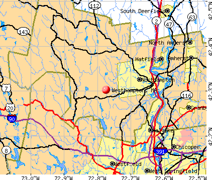
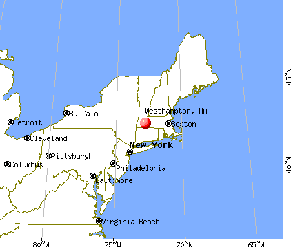
Westhampton, Massachusetts
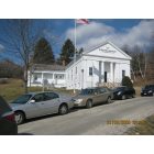
Westhampton: Westhampton Town hall

Westhampton: RECORD OCTOBER SNOW - 19.3"

Westhampton: RECORD OCTOBER SNOW - 19.3"

Westhampton: WAITING FOR THE RAIN
- add
your
Submit your own pictures of this town and show them to the world
- OSM Map
- General Map
- Google Map
- MSN Map
Population change since 2000: +9.5%
 |
| Males: 773 | |
| Females: 834 |
| Median resident age: | 46.5 years |
| Massachusetts median age: | 39.2 years |
Zip codes: 01027.
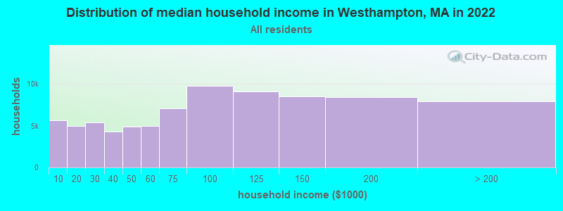
| Westhampton: | $106,989 |
| MA: | $94,488 |
Estimated per capita income in 2022: $48,644 (it was $25,360 in 2000)
Westhampton town income, earnings, and wages data
Estimated median house or condo value in 2022: $440,770 (it was $169,600 in 2000)
| Westhampton: | $440,770 |
| MA: | $534,700 |
Mean prices in 2022: all housing units: $406,762; detached houses: $418,541; townhouses or other attached units: $363,334; in 2-unit structures: $269,911; in 3-to-4-unit structures: $561,325; in 5-or-more-unit structures: $236,751; mobile homes: $362,036
Detailed information about poverty and poor residents in Westhampton, MA


- 1,55897.0%White alone
- 301.9%Hispanic
- 80.5%Asian alone
- 60.4%Two or more races
- 20.1%Black alone
- 20.1%Other race alone
- 10.06%American Indian alone

Races in Westhampton detailed stats: ancestries, foreign born residents, place of birth
Type |
2009 |
2010 |
2011 |
2012 |
2013 |
|---|---|---|---|---|---|
| Murders (per 100,000) | 0 (0.0) | 0 (0.0) | 0 (0.0) | 0 (0.0) | 0 (0.0) |
| Rapes (per 100,000) | 0 (0.0) | 0 (0.0) | 0 (0.0) | 0 (0.0) | 0 (0.0) |
| Robberies (per 100,000) | 0 (0.0) | 0 (0.0) | 0 (0.0) | 0 (0.0) | 0 (0.0) |
| Assaults (per 100,000) | 1 (61.2) | 0 (0.0) | 0 (0.0) | 0 (0.0) | 0 (0.0) |
| Burglaries (per 100,000) | 4 (244.8) | 2 (124.5) | 4 (247.4) | 3 (185.4) | 3 (187.3) |
| Thefts (per 100,000) | 3 (183.6) | 4 (248.9) | 1 (61.8) | 2 (123.6) | 2 (124.8) |
| Auto thefts (per 100,000) | 0 (0.0) | 0 (0.0) | 0 (0.0) | 0 (0.0) | 0 (0.0) |
| Arson (per 100,000) | 0 (0.0) | 0 (0.0) | 0 (0.0) | 0 (0.0) | 0 (0.0) |
| City-Data.com crime index | 36.7 | 18.7 | 19.8 | 17.9 | 18.1 |
The City-Data.com crime index weighs serious crimes and violent crimes more heavily. Higher means more crime, U.S. average is 246.1. It adjusts for the number of visitors and daily workers commuting into cities.

Crime rate in Westhampton detailed stats: murders, rapes, robberies, assaults, burglaries, thefts, arson
 Recent articles from our blog. Our writers, many of them Ph.D. graduates or candidates, create easy-to-read articles on a wide variety of topics.

 | When animals attack in Massechusetts (58 replies) |
| 1 day trip across MA - what route for iconic scenery? (43 replies) |
| Is it possible to escape hunters, ATVs and noise in a rural area? (278 replies) |
| What's up with all the dogs? (44 replies) |
| TS Henri (91 replies) |
| New Job in Springfield MA (Baystate) Housing Options (33 replies) |
Latest news from Westhampton, MA collected exclusively by city-data.com from local newspapers, TV, and radio stations
Ancestries: English (18.9%), Polish (16.1%), French (15.3%), Irish (15.3%), French Canadian (12.4%), German (7.5%).
Current Local Time: EST time zone
Incorporated in 1778
Elevation: 730 feet
Land area: 27.1 square miles.
Population density: 59 people per square mile (very low).
20 residents are foreign born
| This town: | 1.4% |
| Massachusetts: | 12.2% |
| Westhampton town: | 1.4% ($2,432) |
| Massachusetts: | 1.3% ($2,336) |
Nearest city with pop. 50,000+: Chicopee, MA  (13.3 miles , pop. 54,653).
Nearest city with pop. 200,000+: Boston, MA (85.9 miles , pop. 589,141).
Nearest city with pop. 1,000,000+: Bronx, NY (116.2 miles , pop. 1,332,650).
Nearest cities:
), ), ), ), ), )Latitude: 42.31 N, Longitude: 72.77 W
Area code commonly used in this area: 413

Single-family new house construction building permits:
- 2022: 5 buildings, average cost: $453,900
- 2021: 7 buildings, average cost: $498,100
- 2020: 7 buildings, average cost: $314,300
- 2019: 1 building, cost: $347,000
- 2018: 7 buildings, average cost: $285,700
- 2017: 5 buildings, average cost: $330,100
- 2016: 4 buildings, average cost: $178,800
- 2015: 2 buildings, average cost: $329,200
- 2014: 2 buildings, average cost: $204,500
- 2013: 3 buildings, average cost: $828,300
- 2012: 2 buildings, average cost: $325,000
- 2010: 1 building, cost: $100,000
- 2009: 1 building, cost: $100,000
- 2008: 5 buildings, average cost: $256,400
- 2007: 6 buildings, average cost: $229,400
- 2006: 7 buildings, average cost: $186,400
- 2005: 13 buildings, average cost: $207,300
- 2004: 11 buildings, average cost: $148,300
- 2003: 17 buildings, average cost: $171,700
- 2002: 12 buildings, average cost: $177,000
- 2001: 9 buildings, average cost: $168,700
- 2000: 11 buildings, average cost: $146,500
- 1999: 14 buildings, average cost: $130,100
- 1998: 5 buildings, average cost: $85,800
- 1997: 8 buildings, average cost: $112,600


| Here: | 3.2% |
| Massachusetts: | 3.5% |


- Educational services (17.7%)
- Health care (13.3%)
- Construction (8.1%)
- Public administration (5.4%)
- Professional, scientific, technical services (4.5%)
- Finance & insurance (3.5%)
- Agriculture, forestry, fishing & hunting (3.3%)

- Educational services (14.8%)
- Construction (13.2%)
- Public administration (7.1%)
- Health care (6.6%)
- Accommodation & food services (4.3%)
- Agriculture, forestry, fishing & hunting (4.1%)
- Administrative & support & waste management services (3.9%)

- Educational services (20.7%)
- Health care (20.5%)
- Professional, scientific, technical services (5.6%)
- Finance & insurance (4.6%)
- Public administration (3.7%)
- Food & beverage stores (3.4%)
- Social assistance (2.9%)

- Other management occupations, except farmers and farm managers (4.6%)
- Electrical equipment mechanics and other installation, maintenance, and repair workers, including supervisors (4.5%)
- Counselors, social workers, and other community and social service specialists (3.9%)
- Secretaries and administrative assistants (3.8%)
- Material recording, scheduling, dispatching, and distributing workers (3.7%)
- Other sales and related occupations, including supervisors (3.4%)
- Preschool, kindergarten, elementary, and middle school teachers (3.3%)

- Electrical equipment mechanics and other installation, maintenance, and repair workers, including supervisors (8.2%)
- Other management occupations, except farmers and farm managers (5.0%)
- Carpenters (4.8%)
- Material recording, scheduling, dispatching, and distributing workers (4.8%)
- Supervisors, construction and extraction workers (4.3%)
- Building and grounds cleaning and maintenance occupations (3.4%)
- Engineers (3.2%)

- Secretaries and administrative assistants (7.8%)
- Other sales and related occupations, including supervisors (6.1%)
- Registered nurses (6.1%)
- Bookkeeping, accounting, and auditing clerks (5.4%)
- Preschool, kindergarten, elementary, and middle school teachers (5.1%)
- Accountants and auditors (4.9%)
- Counselors, social workers, and other community and social service specialists (4.6%)
Average climate in Westhampton, Massachusetts
Based on data reported by over 4,000 weather stations


(lower is better)

Air Quality Index (AQI) level in 2022 was 74.4. This is about average.
| City: | 74.4 |
| U.S.: | 72.6 |

Carbon Monoxide (CO) [ppm] level in 2019 was 0.346. This is worse than average. Closest monitor was 11.9 miles away from the city center.
| City: | 0.346 |
| U.S.: | 0.251 |

Nitrogen Dioxide (NO2) [ppb] level in 2001 was 9.83. This is significantly worse than average. Closest monitor was 11.6 miles away from the city center.
| City: | 9.83 |
| U.S.: | 5.11 |

Sulfur Dioxide (SO2) [ppb] level in 2022 was 0.168. This is significantly better than average. Closest monitor was 7.5 miles away from the city center.
| City: | 0.168 |
| U.S.: | 1.515 |

Ozone [ppb] level in 2022 was 28.5. This is about average. Closest monitor was 13.1 miles away from the city center.
| City: | 28.5 |
| U.S.: | 33.3 |


Particulate Matter (PM2.5) [µg/m3] level in 2022 was 6.85. This is about average. Closest monitor was 13.5 miles away from the city center.
| City: | 6.85 |
| U.S.: | 8.11 |
Tornado activity:
Westhampton-area historical tornado activity is above Massachusetts state average. It is 9% smaller than the overall U.S. average.
On 10/3/1979, a category F4 (max. wind speeds 207-260 mph) tornado 18.3 miles away from the Westhampton town center killed 3 people and injured 500 people and caused between $50,000,000 and $500,000,000 in damages.
On 5/29/1995, a category F4 tornado 22.7 miles away from the town center killed 3 people and injured 24 people and caused between $5,000,000 and $50,000,000 in damages.
Earthquake activity:
Westhampton-area historical earthquake activity is significantly above Massachusetts state average. It is 70% smaller than the overall U.S. average.On 10/7/1983 at 10:18:46, a magnitude 5.3 (5.1 MB, 5.3 LG, 5.1 ML, Class: Moderate, Intensity: VI - VII) earthquake occurred 138.7 miles away from the city center
On 4/20/2002 at 10:50:47, a magnitude 5.3 (5.3 ML, Depth: 3.0 mi) earthquake occurred 159.4 miles away from Westhampton center
On 4/20/2002 at 10:50:47, a magnitude 5.2 (5.2 MB, 4.2 MS, 5.2 MW, 5.0 MW) earthquake occurred 158.0 miles away from Westhampton center
On 1/19/1982 at 00:14:42, a magnitude 4.7 (4.5 MB, 4.7 MD, 4.5 LG, Class: Light, Intensity: IV - V) earthquake occurred 101.4 miles away from the city center
On 10/16/2012 at 23:12:25, a magnitude 4.7 (4.7 ML, Depth: 10.0 mi) earthquake occurred 139.2 miles away from the city center
On 8/23/2011 at 17:51:04, a magnitude 5.8 (5.8 MW, Depth: 3.7 mi) earthquake occurred 408.9 miles away from Westhampton center
Magnitude types: regional Lg-wave magnitude (LG), body-wave magnitude (MB), duration magnitude (MD), local magnitude (ML), surface-wave magnitude (MS), moment magnitude (MW)
Natural disasters:
The number of natural disasters in Hampshire County (21) is greater than the US average (15).Major Disasters (Presidential) Declared: 10
Emergencies Declared: 10
Causes of natural disasters: Floods: 5, Snowstorms: 5, Storms: 5, Hurricanes: 4, Winter Storms: 4, Blizzards: 2, Snows: 2, Snowfall: 1, Tropical Storm: 1, Wind: 1, Other: 1 (Note: some incidents may be assigned to more than one category).

Hospitals and medical centers near Westhampton:
- NORTHAMPTON VA MEDICAL CENTER (Hospital, Acute Care - Veterans Administration, about 5 miles away; LEEDS, MA)
- OVERLOOK AT NORTHAMPTON (Nursing Home, about 6 miles away; LEEDS, MA)
- LINDA MANOR EXTENDED CARE FACILITY (Nursing Home, about 6 miles away; LEEDS, MA)
- CALVIN COOLIDGE NURING AND REHAB CTR - NORTHAMPTON (Nursing Home, about 6 miles away; NORTHAMPTON, MA)
- COOLEY DICKINSON HOSPITAL INC,THE Acute Care Hospitals (about 6 miles away; NORTHAMPTON, MA)
- NORTHAMPTON REHABILITATION AND NURSING CENTER (Nursing Home, about 7 miles away; NORTHAMPTON, MA)
- PINE REST NURSING HOME (Nursing Home, about 7 miles away; NORTHAMPTON, MA)
Amtrak stations near Westhampton:
- 14 miles: AMHERST (RAILROAD ST.) . Services: enclosed waiting area, public payphones, free short-term parking, paid long-term parking, call for car rental service, call for taxi service, public transit connection.
- 17 miles: SPRINGFIELD (66 LYMAN ST.) . Services: ticket office, partially wheelchair accessible, enclosed waiting area, public restrooms, public payphones, full-service food facilities, snack bar, vending machines, ATM, paid short-term parking, paid long-term parking, call for car rental service, taxi stand, intercity bus service, public transit connection.
Colleges/universities with over 2000 students nearest to Westhampton:
- Smith College (about 7 miles; Northampton, MA; Full-time enrollment: 3,549)
- Holyoke Community College (about 10 miles; Holyoke, MA; FT enrollment: 4,911)
- Mount Holyoke College (about 11 miles; South Hadley, MA; FT enrollment: 2,573)
- Westfield State University (about 13 miles; Westfield, MA; FT enrollment: 5,548)
- University of Massachusetts-Amherst (about 14 miles; Amherst, MA; FT enrollment: 26,583)
- Springfield Technical Community College (about 17 miles; Springfield, MA; FT enrollment: 4,750)
- American International College (about 18 miles; Springfield, MA; FT enrollment: 2,733)
Public high school in Westhampton:
- HAMPSHIRE REGIONAL HIGH (Students: 814, Location: 19 STAGE RD, Grades: 7-12)
Public elementary/middle school in Westhampton:
- WESTHAMPTON ELEMENTARY SCHOOL (Students: 149, Location: 37 KINGS HIGHWAY, Grades: PK-6)
Points of interest:
Notable locations in Westhampton: Outlook Farm (A), Westhampton Town Hall (B), Westhampton Fire Department (C), Westhampton Memorial Library (D). Display/hide their locations on the map
Lakes and reservoirs: Hanging Mountain Pond (A), Pine Island Lake (B). Display/hide their locations on the map
Streams, rivers, and creeks: Sodom Brook (A), Rice Brook (B), Lyman Brook (C), Brewer Brook (D), Shop Brook (E). Display/hide their locations on the map
Drinking water stations with addresses in Westhampton that have no violations reported:
- WINDY ACRES CAMPGROUND (Population served: 200, Primary Water Source Type: Groundwater)
| This town: | 2.6 people |
| Massachusetts: | 2.5 people |
| This town: | 76.2% |
| Whole state: | 63.0% |
| This town: | 7.4% |
| Whole state: | 7.0% |
Likely homosexual households (counted as self-reported same-sex unmarried-partner households)
- Lesbian couples: 2.1% of all households
- Gay men: 0.2% of all households
| This town: | 3.5% |
| Whole state: | 9.3% |
| This town: | 2.2% |
| Whole state: | 4.4% |
For population 15 years and over in Westhampton:

- Never married: 19.2%
- Now married: 67.0%
- Separated: 1.1%
- Widowed: 4.0%
- Divorced: 8.6%
For population 25 years and over in Westhampton:
- High school or higher: 92.6%
- Bachelor's degree or higher: 34.9%
- Graduate or professional degree: 14.5%
- Unemployed: 1.3%
- Mean travel time to work (commute): 25.2 minutes


| Here: | 10.0 |
| Massachusetts average: | 13.1 |
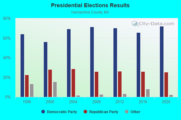
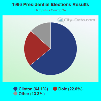
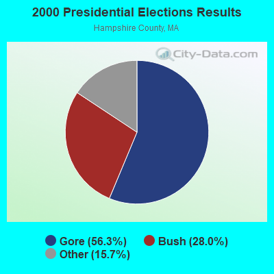
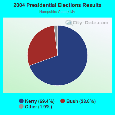
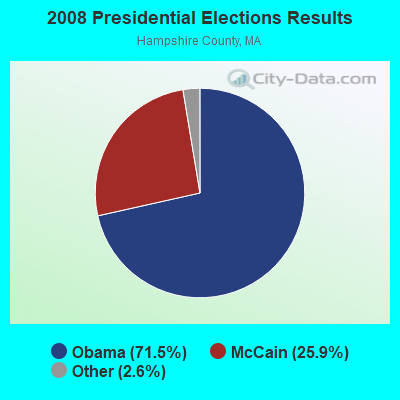
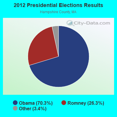
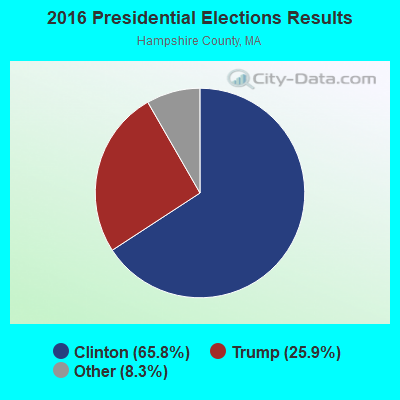
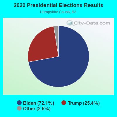
Graphs represent county-level data. Detailed 2008 Election Results
Religion statistics for Westhampton, MA (based on Hampshire County data)
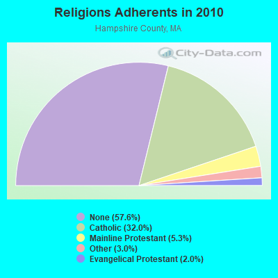
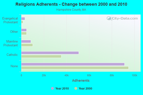
| Religion | Adherents | Congregations |
|---|---|---|
| Catholic | 50,643 | 22 |
| Mainline Protestant | 8,454 | 45 |
| Other | 4,722 | 27 |
| Evangelical Protestant | 3,128 | 22 |
| Black Protestant | 29 | 1 |
| None | 91,104 | - |
Food Environment Statistics:
| Hampshire County: | 2.07 / 10,000 pop. |
| Massachusetts: | 1.98 / 10,000 pop. |
| Hampshire County: | 0.06 / 10,000 pop. |
| State: | 0.05 / 10,000 pop. |
| Here: | 1.55 / 10,000 pop. |
| State: | 2.22 / 10,000 pop. |
| Hampshire County: | 1.94 / 10,000 pop. |
| Massachusetts: | 1.77 / 10,000 pop. |
| This county: | 10.22 / 10,000 pop. |
| Massachusetts: | 8.76 / 10,000 pop. |
| Hampshire County: | 7.3% |
| State: | 8.1% |
| Hampshire County: | 21.7% |
| Massachusetts: | 22.5% |
| Hampshire County: | 12.3% |
| Massachusetts: | 16.5% |
Strongest AM radio stations in Westhampton:
- WNNZ (640 AM; 50 kW; WESTFIELD, MA; Owner: CLEAR CHANNEL BROADCASTING LICENSES, INC.)
- WHYN (560 AM; 5 kW; SPRINGFIELD, MA; Owner: CLEAR CHANNEL BROADCASTING LICENSES, INC.)
- WACE (730 AM; 5 kW; CHICOPEE, MA; Owner: CARTER BROADCASTING CORP.)
- WTIC (1080 AM; 50 kW; HARTFORD, CT; Owner: INFINITY RADIO OPERATIONS INC.)
- WCRN (830 AM; 50 kW; WORCESTER, MA; Owner: CARTER BROADCASTING CORPORATION)
- WVNE (760 AM; daytime; 25 kW; LEICESTER, MA; Owner: BLOUNT MASSCOM, INC.)
- WHMP (1400 AM; 1 kW; NORTHAMPTON, MA; Owner: SAGA COMMUNICATIONS OF NEW ENGLAND, LLC)
- WPNI (1430 AM; 5 kW; AMHERST, MA; Owner: WESTERN MASSACHUSETTS RADIO COMPANY)
- WSPR (1270 AM; 5 kW; SPRINGFIELD, MA; Owner: ANTONIO F. AND HELENA R. GOIS, TENANTS BY THE ENTIRETY)
- WIZZ (1520 AM; daytime; 10 kW; GREENFIELD, MA; Owner: P. & M. RADIO, LLC)
- WALE (990 AM; 50 kW; GREENVILLE, RI; Owner: NORTH AMERICAN BROADCASTING CO., INC.)
- WGY (810 AM; 50 kW; SCHENECTADY, NY; Owner: CLEAR CHANNEL BROADCASTING LICENSES, INC.)
- WRKO (680 AM; 50 kW; BOSTON, MA; Owner: ENTERCOM BOSTON LICENSE, LLC)
Strongest FM radio stations in Westhampton:
- WHYN-FM (93.1 FM; SPRINGFIELD, MA; Owner: CLEAR CHANNEL BROADCASTING LICENSES, INC.)
- WRNX (100.9 FM; AMHERST, MA; Owner: WESTERN MASSACHUSETTS RADIO COMPANY)
- WLZX (99.3 FM; NORTHAMPTON, MA; Owner: SAGA COMMUNICATIONS OF NEW ENGLAND, LLC)
- WEIB (106.3 FM; NORTHAMPTON, MA; Owner: CUTTING EDGE BROADCASTING, INC.)
- WAMC-FM (90.3 FM; ALBANY, NY; Owner: WAMC)
- WFCR (88.5 FM; AMHERST, MA; Owner: UNIVERSITY OF MASSACHUSETTS)
- WAQY (102.1 FM; SPRINGFIELD, MA; Owner: SAGA COMMUNICATIONS OF NEW ENGLAND, LLC)
- WAMH (89.3 FM; AMHERST, MA; Owner: TRUSTEES OF AMHERST COLLEGE)
- W246AM (97.1 FM; AMHERST, MA; Owner: GREAT NORTHERN RADIO, LLC)
- WPKX (97.9 FM; ENFIELD, CT; Owner: CAPSTAR TX LIMITED PARTNERSHIP)
- WCCH (103.5 FM; HOLYOKE, MA; Owner: HOLYOKE COMMUNITY COLLEGE)
- WEQX (102.7 FM; MANCHESTER, VT; Owner: NORTHSHIRE COMMUNICATIONS, INC.)
- WJAN (95.1 FM; SUNDERLAND, VT; Owner: 6 JOHNSON ROAD LICENSES, INC.)
- WPVQ (95.3 FM; GREENFIELD, MA; Owner: GREAT NORTHERN RADIO, L.L.C.)
- WVAY (100.7 FM; WILMINGTON, VT; Owner: GREAT NORTHERN RADIO, L.L.C.)
- WRCH (100.5 FM; NEW BRITAIN, CT; Owner: INFINITY RADIO OPERATIONS INC.)
- WHVP (91.1 FM; HUDSON, NY; Owner: SOUND OF LIFE, INC.)
- WHAI (98.3 FM; GREENFIELD, MA; Owner: SAGA COMMUNICATIONS OF NEW ENGLAND, LLC)
- WRSI (93.9 FM; TURNERS FALLS, MA; Owner: GREAT NORTHERN RADIO, LLC)
- WAMQ (105.1 FM; GREAT BARRINGTON, MA; Owner: WAMC)
TV broadcast stations around Westhampton:
- WYDN (Channel 48; WORCESTER, MA; Owner: EDUCATIONAL PUBLIC TV CORPORATION)
- W67DF (Channel 67; SPRINGFIELD, MA; Owner: TRINITY BROADCASTING NETWORK)
- WWLP (Channel 22; SPRINGFIELD, MA; Owner: WWLP BROADCASTING, LLC)
- WTIC-TV (Channel 61; HARTFORD, CT; Owner: TRIBUNE TELEVISION COMPANY)
- W11BJ (Channel 11; HARTFORD, CT; Owner: COMMUNICATIONS SITE MANAGEMENT LLC)
- WGGB-TV (Channel 40; SPRINGFIELD, MA; Owner: WGGB LICENSEE, LLC)
- WGBY-TV (Channel 57; SPRINGFIELD, MA; Owner: WGBH EDUCATIONAL FOUNDATION)
- WUVN (Channel 18; HARTFORD, CT; Owner: ENTRAVISION HOLDINGS, LLC)
- WTXX (Channel 20; WATERBURY, CT; Owner: WTXX INC.)
- WVIT (Channel 30; NEW BRITAIN, CT; Owner: OUTLET BROADCASTING, INC)
- WEDH (Channel 24; HARTFORD, CT; Owner: CONNECTICUT PUBLIC BROADCASTING, INC.)
- W35BK (Channel 35; PLAINFIELD, MA; Owner: LYDIA SYLVANE STOCKWELL)
- WDMR-LP (Channel 65; SPRINGFIELD, MA; Owner: ZGS HARTFORD, INC.)
Westhampton fatal accident list:
Apr 13, 2015 03:30 PM, Main Road, Lat: 42.286761, Lon: -72.801331, Vehicles: 1, Persons: 1, Fatalities: 1
May 3, 2015 03:30 AM, Sr-66 Main Road, Lat: 42.289092, Lon: -72.742861, Vehicles: 1, Persons: 1, Fatalities: 1, Drunk persons involved: 1
Jul 24, 1999 02:05 AM, Stage Rd, Vehicles: 1, Persons: 1, Fatalities: 1, Drunk persons involved: 1
Jun 19, 1986 09:25 PM, N West Rd, Vehicles: 1, Persons: 2, Fatalities: 1, Drunk persons involved: 1
- National Bridge Inventory (NBI) Statistics
- 14Number of bridges
- 59ft / 17.9mTotal length
- $11,349,000Total costs
- 20,590Total average daily traffic
- 1,176Total average daily truck traffic
- 16,434Total future (year 2031) average daily traffic

- New bridges - historical statistics
- 41930-1939
- 41940-1949
- 21950-1959
- 11960-1969
- 11990-1999
- 12000-2009
- 12010-2019
FCC Registered Antenna Towers:
10 (See the full list of FCC Registered Antenna Towers in Westhampton)FCC Registered Amateur Radio Licenses:
7- Call Sign: KB1EDZ, Licensee ID: L00261969, Grant Date: 03/10/2009, Expiration Date: 06/04/2019, Cancellation Date: 10/20/2012, Certifier: Gary P Dion, Registrant: Gary P Dion, 127 Edwards Rd, Westhampton, MA 01027
- Call Sign: N1LZN, Previous Call Sign: KA1ZMS, Licensee ID: L00447044, Grant Date: 01/26/2012, Expiration Date: 04/07/2022, Certifier: Lorrie A Gougeon, Registrant: Lorrie A Gougeon, 95 Montague Rd, Westhampton, MA 01027
- Call Sign: W1VG, Previous Call Sign: KB1EDZ, Licensee ID: L00261969, Grant Date: 11/17/2022, Expiration Date: 11/17/2032, Certifier: Gary P Dion, Registrant: Gary P Dion, 127 Edwards Rd, Westhampton, MA 01027
- Call Sign: KC1CXD, Licensee ID: L01908141, Grant Date: 12/02/2014, Expiration Date: 12/02/2024, Certifier: John O Zimmerman, Registrant: John O Zimmerman, 48 North Road, Westhampton, MA 01027
- Call Sign: KC1OKD, Licensee ID: L02395493, Grant Date: 01/06/2021, Expiration Date: 01/06/2031, Certifier: Todd Alexander, Registrant: Todd Alexander, 202 Reservoir Rd, Westhampton, MA 01027
- Call Sign: KC1SYA, Licensee ID: L02666011, Grant Date: 05/09/2023, Expiration Date: 05/09/2033, Cancellation Date: 05/27/2023, Certifier: Stephan B Wurmbrand, Registrant: Stephan B Wurmbrand, 29 Edwards Rd, Westhampton, MA 01027
- Call Sign: K1SWX, Previous Call Sign: KC1SYA, Licensee ID: L02666011, Grant Date: 05/27/2023, Expiration Date: 05/27/2033, Certifier: Stephan B Wurmbrand, Registrant: Stephan B Wurmbrand, 29 Edwards Rd, Westhampton, MA 01027
FAA Registered Aircraft:
5- Aircraft: CESSNA 172L (Category: Land, Seats: 4, Weight: Up to 12,499 Pounds, Speed: 105 mph), Engine: LYCOMING 0-320 SERIES (180 HP) (Reciprocating)
N-Number: 5PT, N5PT, N-5PT, Serial Number: 17260628, Year manufactured: 1972, Airworthiness Date: 05/11/1972, Certificate Issue Date: 06/12/1986
Registrant (Individual): George R Munson, 74 Stage Rd, Westhampton, MA 01027 - Aircraft: PIPER PA-28-235 (Category: Land, Seats: 4, Weight: Up to 12,499 Pounds, Speed: 107 mph), Engine: LYCOMING 0-540 SERIES (250 HP) (Reciprocating)
N-Number: 9351W, N9351W, N-9351W, Serial Number: 28-11103, Year manufactured: 1968, Airworthiness Date: 09/05/1968, Certificate Issue Date: 04/06/2000
Registrant (Individual): Stephan B Wurmbrand, 29 Edwards Rd, Westhampton, MA 01027 - Aircraft: GRUMMAN AMERICAN AVN. CORP. AA-1C (Category: Land, Seats: 2, Weight: Up to 12,499 Pounds), Engine: LYCOMING 0-235 SERIES (115 HP) (Reciprocating)
N-Number: 9553U, N9553U, N-9553U, Serial Number: AA1C0051, Year manufactured: 1977, Certificate Issue Date: 06/26/2002
Registrant (Individual): Thaddeus J Jr Witowski, 157 Edwards Rd, Westhampton, MA 01027 - Aircraft: MAULE MX-7-180C (Category: Land, Seats: 5, Weight: Up to 12,499 Pounds), Engine: Reciprocating
N-Number: 9951, N9951, N-9951, Serial Number: 28027C, Certificate Issue Date: 08/21/2017
Registrant (Individual): Stephan Wurmbrand, 29 Edwards Rd, Westhampton, MA 01027 - Aircraft: CESSNA 172P (Category: Land, Seats: 4, Weight: Up to 12,499 Pounds), Engine: LYCOMING 0-320 SERIES (180 HP) (Reciprocating)
N-Number: 99783, N99783, N-99783, Serial Number: 17276510, Year manufactured: 1985, Airworthiness Date: 09/30/1985, Certificate Issue Date: 01/25/2012
Registrant (Co-Owned): Todd Alexander, 202 Reservoir Rd, Westhampton, MA 01027, Other Owners: Christopher Taylor
2002 - 2018 National Fire Incident Reporting System (NFIRS) incidents
- Fire incident types reported to NFIRS in Westhampton, MA
- 9745.3%Structure Fires
- 6229.0%Outside Fires
- 4219.6%Other
- 136.1%Mobile Property/Vehicle Fires
 According to the data from the years 2002 - 2018 the average number of fire incidents per year is 13. The highest number of reported fire incidents - 28 took place in 2009, and the least - 1 in 2002. The data has a rising trend.
 When looking into fire subcategories, the most incidents belonged to: Structure Fires (45.3%), and Outside Fires (29.0%).
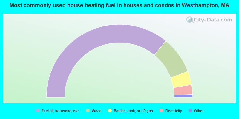
- 71.9%Fuel oil, kerosene, etc.
- 16.6%Wood
- 6.1%Bottled, tank, or LP gas
- 4.3%Electricity
- 0.8%Other fuel
- 0.4%Coal or coke
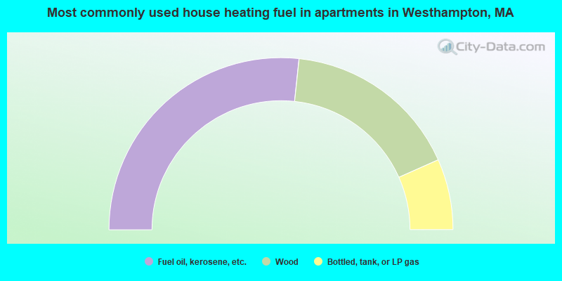
- 53.3%Fuel oil, kerosene, etc.
- 33.3%Wood
- 13.3%Bottled, tank, or LP gas
Westhampton compared to Massachusetts state average:
- Unemployed percentage significantly below state average.
- Black race population percentage significantly below state average.
- Hispanic race population percentage significantly below state average.
- Median age above state average.
- Foreign-born population percentage significantly below state average.
- Renting percentage significantly below state average.
- Length of stay since moving in significantly above state average.
- Number of rooms per house significantly below state average.
- House age significantly below state average.
- Number of college students below state average.
Westhampton on our top lists:
- #80 on the list of "Top 101 cities with the most residents born in Other Northern America (population 500+)"
- #2 on the list of "Top 101 counties with the lowest number of births per 1000 residents 2007-2013"
- #9 on the list of "Top 101 counties with the lowest Particulate Matter (PM10) Annual air pollution readings in 2012 (µg/m3)"
- #19 on the list of "Top 101 counties with the lowest average weight of females"
- #30 on the list of "Top 101 counties with highest percentage of residents voting for 3rd party candidates in the 2012 Presidential Election (pop. 50,000+)"
- #41 on the list of "Top 101 counties with the highest percentage of residents that exercised in the past month"

|
|
Total of 17 patent applications in 2008-2024.