Cottonburg-Valley View, Kentucky
Submit your own pictures of this place and show them to the world
- OSM Map
- Google Map
- MSN Map
| Males: 894 | |
| Females: 866 |
| Median resident age: | 37.1 years |
| Kentucky median age: | 35.9 years |
Zip code: 40475
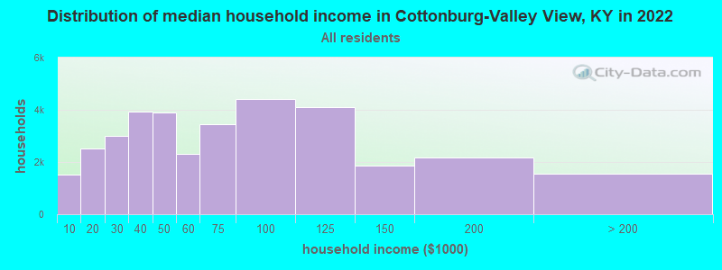
| Cottonburg-Valley View: | $56,896 |
| KY: | $59,341 |
Estimated per capita income in 2022: $28,355 (it was $14,796 in 2000)
Cottonburg-Valley View CCD income, earnings, and wages data
Estimated median house or condo value in 2022: $192,808 (it was $77,000 in 2000)
| Cottonburg-Valley View: | $192,808 |
| KY: | $196,300 |
Mean prices in 2022: all housing units: $235,586; detached houses: $252,818; townhouses or other attached units: $461,054; in 2-unit structures: $153,718; mobile homes: $71,686
Cottonburg-Valley View, KY residents, houses, and apartments details
Detailed information about poverty and poor residents in Cottonburg-Valley View, KY


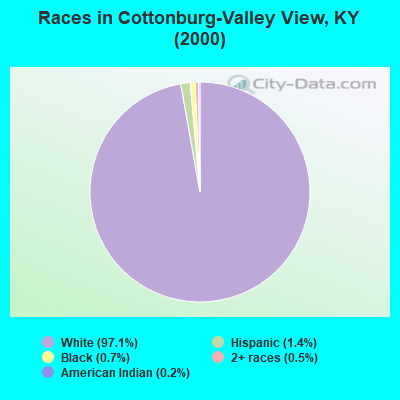
- 1,50097.1%White alone
- 211.4%Hispanic
- 110.7%Black alone
- 80.5%Two or more races
- 30.2%American Indian alone
- 10.06%Asian alone
- 10.06%Other race alone
Races in Cottonburg-Valley View detailed stats: ancestries, foreign born residents, place of birth
 Recent articles from our blog. Our writers, many of them Ph.D. graduates or candidates, create easy-to-read articles on a wide variety of topics.
Current Local Time: EST time zone
Land area: 55.7 square miles.
Population density: 32 people per square mile (very low).
| Cottonburg-Valley View CCD: | 0.5% ($400) |
| Kentucky: | 0.8% ($610) |
Nearest city with pop. 50,000+: Fayette, KY  (17.6 miles , pop. 260,512).
Nearest city with pop. 1,000,000+: Chicago, IL (329.7 miles , pop. 2,896,016).
Nearest cities:
), ), ), )Latitude: 37.78 N, Longitude: 84.43 W
Area code commonly used in this area: 859
| Here: | 3.6% |
| Kentucky: | 3.8% |
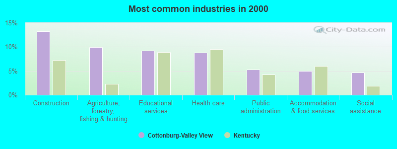
- Construction (13.2%)
- Agriculture, forestry, fishing & hunting (9.9%)
- Educational services (9.2%)
- Health care (8.8%)
- Public administration (5.2%)
- Accommodation & food services (5.0%)
- Social assistance (4.7%)
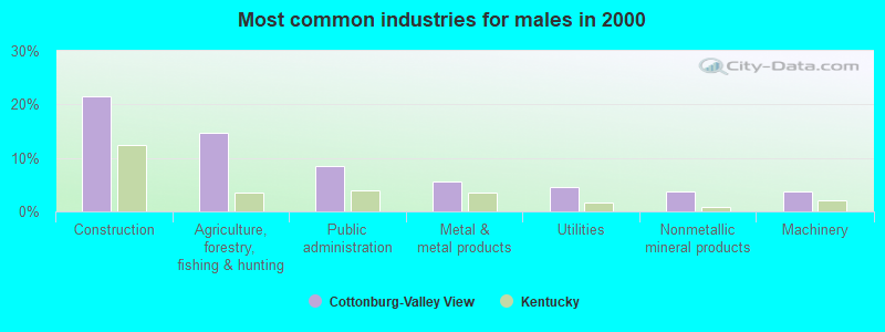
- Construction (21.6%)
- Agriculture, forestry, fishing & hunting (14.6%)
- Public administration (8.5%)
- Metal & metal products (5.6%)
- Utilities (4.5%)
- Nonmetallic mineral products (3.8%)
- Machinery (3.8%)
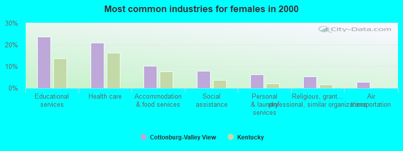
- Educational services (23.8%)
- Health care (20.9%)
- Accommodation & food services (10.3%)
- Social assistance (7.8%)
- Personal & laundry services (6.4%)
- Religious, grantmaking, civic, professional, similar organizations (5.3%)
- Air transportation (2.8%)
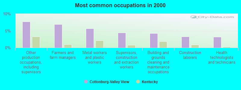
- Other production occupations, including supervisors (7.7%)
- Farmers and farm managers (6.9%)
- Metal workers and plastic workers (5.6%)
- Supervisors, construction and extraction workers (4.4%)
- Building and grounds cleaning and maintenance occupations (4.3%)
- Construction laborers (3.3%)
- Health technologists and technicians (3.2%)
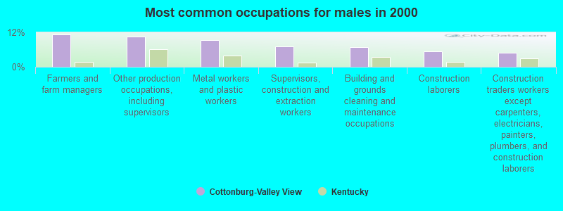
- Farmers and farm managers (11.2%)
- Other production occupations, including supervisors (10.6%)
- Metal workers and plastic workers (9.2%)
- Supervisors, construction and extraction workers (7.2%)
- Building and grounds cleaning and maintenance occupations (7.0%)
- Construction laborers (5.4%)
- Construction traders workers except carpenters, electricians, painters, plumbers, and construction laborers (4.9%)
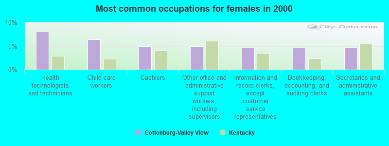
- Health technologists and technicians (8.2%)
- Child care workers (6.4%)
- Cashiers (5.0%)
- Other office and administrative support workers, including supervisors (5.0%)
- Information and record clerks, except customer service representatives (4.6%)
- Bookkeeping, accounting, and auditing clerks (4.6%)
- Secretaries and administrative assistants (4.6%)
Average climate in Cottonburg-Valley View, Kentucky
Based on data reported by over 4,000 weather stations


(lower is better)
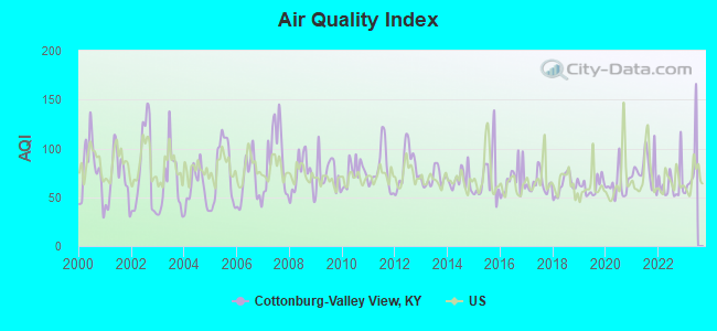
Air Quality Index (AQI) level in 2022 was 64.2. This is about average.
| City: | 64.2 |
| U.S.: | 72.6 |
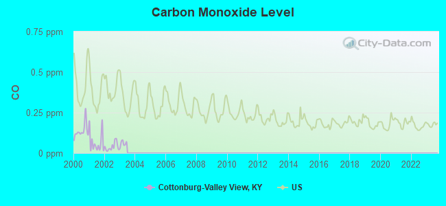
Carbon Monoxide (CO) [ppm] level in 2002 was 0.0391. This is significantly better than average. Closest monitor was 17.7 miles away from the city center.
| City: | 0.0391 |
| U.S.: | 0.2513 |
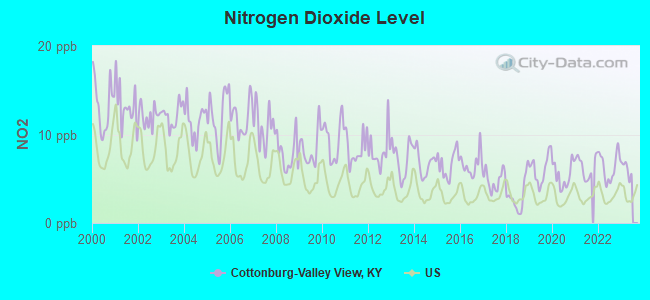
Nitrogen Dioxide (NO2) [ppb] level in 2022 was 6.38. This is worse than average. Closest monitor was 7.8 miles away from the city center.
| City: | 6.38 |
| U.S.: | 5.11 |
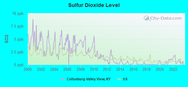
Sulfur Dioxide (SO2) [ppb] level in 2022 was 1.01. This is significantly better than average. Closest monitor was 7.8 miles away from the city center.
| City: | 1.01 |
| U.S.: | 1.51 |
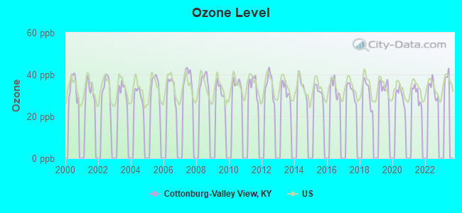
Ozone [ppb] level in 2022 was 33.0. This is about average. Closest monitor was 11.7 miles away from the city center.
| City: | 33.0 |
| U.S.: | 33.3 |
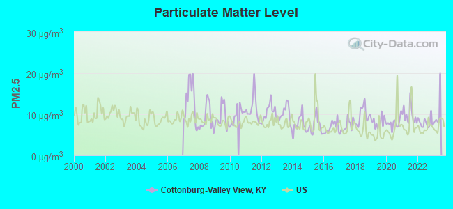
Particulate Matter (PM2.5) [µg/m3] level in 2022 was 7.97. This is about average. Closest monitor was 8.3 miles away from the city center.
| City: | 7.97 |
| U.S.: | 8.11 |
Tornado activity:
Cottonburg-Valley View-area historical tornado activity is near Kentucky state average. It is 16% greater than the overall U.S. average.
On 4/3/1974, a category F4 (max. wind speeds 207-260 mph) tornado 5.9 miles away from the Cottonburg-Valley View place center killed 7 people and injured 28 people.
On 3/4/1955, a category F3 (max. wind speeds 158-206 mph) tornado 4.4 miles away from the place center injured 2 people and caused between $50,000 and $500,000 in damages.
Earthquake activity:
Cottonburg-Valley View-area historical earthquake activity is significantly above Kentucky state average. It is 74% greater than the overall U.S. average.On 7/27/1980 at 18:52:21, a magnitude 5.2 (5.1 MB, 4.7 MS, 5.0 UK, 5.2 UK, Class: Moderate, Intensity: VI - VII) earthquake occurred 39.4 miles away from the city center
On 4/18/2008 at 09:36:59, a magnitude 5.4 (5.1 MB, 4.8 MS, 5.4 MW, 5.2 MW) earthquake occurred 193.9 miles away from the city center
On 9/7/1988 at 02:28:09, a magnitude 4.6 (4.5 MB, 4.6 LG, Class: Light, Intensity: IV - V) earthquake occurred 39.0 miles away from the city center
On 4/18/2008 at 09:36:59, a magnitude 5.2 (5.2 MW, Depth: 8.9 mi) earthquake occurred 193.9 miles away from Cottonburg-Valley View center
On 6/10/1987 at 23:48:54, a magnitude 5.1 (4.9 MB, 4.4 MS, 4.6 MS, 5.1 LG) earthquake occurred 201.0 miles away from Cottonburg-Valley View center
On 6/18/2002 at 17:37:15, a magnitude 5.0 (4.3 MB, 4.6 MW, 5.0 LG) earthquake occurred 183.6 miles away from Cottonburg-Valley View center
Magnitude types: regional Lg-wave magnitude (LG), body-wave magnitude (MB), surface-wave magnitude (MS), moment magnitude (MW)
Natural disasters:
The number of natural disasters in Madison County (19) is greater than the US average (15).Major Disasters (Presidential) Declared: 14
Emergencies Declared: 3
Causes of natural disasters: Floods: 11, Storms: 10, Mudslides: 6, Tornadoes: 6, Winter Storms: 4, Landslides: 2, Blizzard: 1, Freeze: 1, Heavy Rain: 1, Hurricane: 1, Snow: 1, Snowfall: 1, Wind: 1, Other: 1 (Note: some incidents may be assigned to more than one category).
Hospitals and medical centers near Cottonburg-Valley View:
- DCI - RICHMOND (Dialysis Facility, about 6 miles away; RICHMOND, KY)
- MADISON MANOR (Nursing Home, about 7 miles away; RICHMOND, KY)
- KENWOOD HEALTH AND REHABILITATION CENTER (Nursing Home, about 7 miles away; RICHMOND, KY)
- BAPTIST HEALTH RICHMOND Acute Care Hospitals (about 9 miles away; RICHMOND, KY)
- MEPCO HOME HEALTH AGENCY (Home Health Center, about 9 miles away; RICHMOND, KY)
- JESSAMINE CO HOSPICE (Hospital, about 11 miles away; NICHOLASVILLE, KY)
- ROYAL MANOR (Nursing Home, about 11 miles away; NICHOLASVILLE, KY)
Colleges/universities with over 2000 students nearest to Cottonburg-Valley View:
- Eastern Kentucky University (about 8 miles; Richmond, KY; Full-time enrollment: 13,525)
- Bluegrass Community and Technical College (about 18 miles; Lexington, KY; FT enrollment: 8,560)
- University of Kentucky (about 18 miles; Lexington, KY; FT enrollment: 23,517)
- Kentucky State University (about 38 miles; Frankfort, KY; FT enrollment: 2,112)
- Somerset Community College (about 52 miles; Somerset, KY; FT enrollment: 4,698)
- Campbellsville University (about 59 miles; Campbellsville, KY; FT enrollment: 2,948)
- Morehead State University (about 62 miles; Morehead, KY; FT enrollment: 7,523)
Points of interest:
Notable location: Valley View Ferry (A). Display/hide its location on the map
Churches in Cottonburg-Valley View include: Forest Hill Church (A), Newby Church (B), Antioch Church (C), Taylors Chapel (D), Salem Church (E), Corinth Church (F), Cuzick Church (G), Woodland Heights Church (H). Display/hide their locations on the map
Cemeteries: Poosey Cemetery (1), Salem Church Cemetery (2), Freindship Cemetery (3). Display/hide their locations on the map
Streams, rivers, and creeks: Dry Branch (A), Bogie Branch (B), Crutcher Fork (C), Tracy Branch (D), Tate Creek (E), Stony Fork (F), Buffalo Creek (G), Sledd Branch (H), Silver Creek (I). Display/hide their locations on the map
| This place: | 2.5 people |
| Kentucky: | 2.5 people |
| This place: | 73.4% |
| Whole state: | 66.9% |
| This place: | 5.3% |
| Whole state: | 6.4% |
Likely homosexual households (counted as self-reported same-sex unmarried-partner households)
- Lesbian couples: 0.3% of all households
- Gay men: 0.5% of all households
| This place: | 15.4% |
| Whole state: | 15.8% |
| This place: | 7.8% |
| Whole state: | 6.6% |
For population 15 years and over in Cottonburg-Valley View:
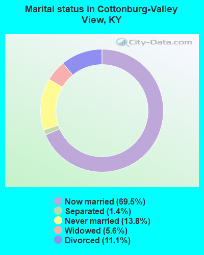
- Never married: 13.8%
- Now married: 69.5%
- Separated: 1.4%
- Widowed: 5.6%
- Divorced: 11.1%
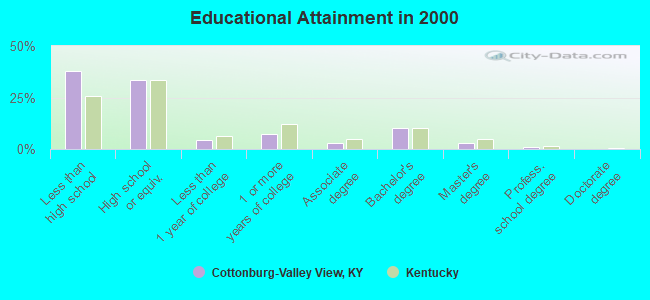
For population 25 years and over in Cottonburg-Valley View:
- High school or higher: 62.2%
- Bachelor's degree or higher: 14.2%
- Graduate or professional degree: 3.9%
- Unemployed: 5.1%
- Mean travel time to work (commute): 37.4 minutes
| Here: | 15.4 |
| Kentucky average: | 13.8 |
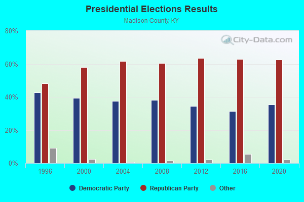
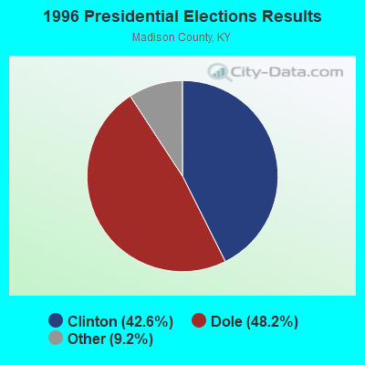
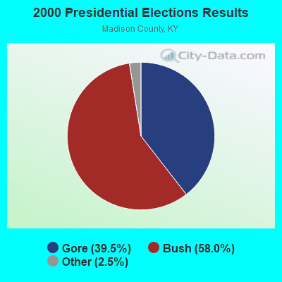
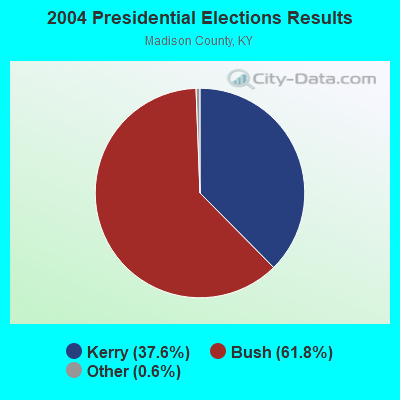
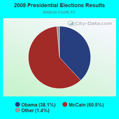
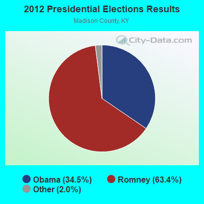
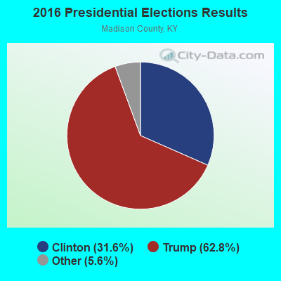
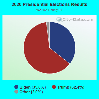
Graphs represent county-level data. Detailed 2008 Election Results
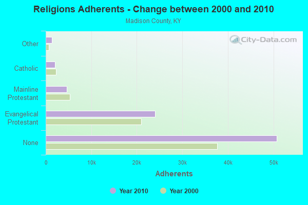
Religion statistics for Cottonburg-Valley View, KY (based on Madison County data)
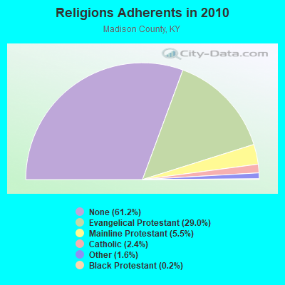
| Religion | Adherents | Congregations |
|---|---|---|
| Evangelical Protestant | 24,041 | 87 |
| Mainline Protestant | 4,596 | 18 |
| Catholic | 2,005 | 2 |
| Other | 1,324 | 6 |
| Black Protestant | 181 | 1 |
| None | 50,769 | - |
Food Environment Statistics:
| Here: | 0.99 / 10,000 pop. |
| Kentucky: | 2.19 / 10,000 pop. |
| Madison County: | 0.25 / 10,000 pop. |
| Kentucky: | 0.25 / 10,000 pop. |
| This county: | 0.99 / 10,000 pop. |
| Kentucky: | 0.74 / 10,000 pop. |
| Madison County: | 5.80 / 10,000 pop. |
| Kentucky: | 4.36 / 10,000 pop. |
| This county: | 4.81 / 10,000 pop. |
| Kentucky: | 5.74 / 10,000 pop. |
| Madison County: | 8.9% |
| Kentucky: | 11.0% |
| Madison County: | 29.1% |
| Kentucky: | 30.0% |
| Here: | 15.3% |
| Kentucky: | 15.9% |
Strongest AM radio stations in Cottonburg-Valley View:
- WCGW (770 AM; daytime; 1 kW; NICHOLASVILLE, KY; Owner: MORTENSON BROADCASTING COMPANY)
- WHAS (840 AM; 50 kW; LOUISVILLE, KY; Owner: CLEAR CHANNEL BROADCASTING LICENSES, INC.)
- WVLK (590 AM; 5 kW; LEXINGTON, KY; Owner: CUMULUS LICENSING CORP.)
- WLAP (630 AM; 5 kW; LEXINGTON, KY; Owner: CITICASTERS LICENSES, L.P.)
- WEKY (1340 AM; 1 kW; RICHMOND, KY; Owner: WALLINGFORD COMMUNICATIONS, LLC)
- WXRA (1580 AM; 10 kW; GEORGETOWN, KY; Owner: CITICASTERS LICENSES, L.P.)
- WLW (700 AM; 50 kW; CINCINNATI, OH; Owner: JACOR BROADCASTING CORPORATION)
- WKYY (1280 AM; 1 kW; LANCASTER, KY; Owner: LANCASTER BROADCASTERS, INC.)
- WSAI (1530 AM; 50 kW; CINCINNATI, OH; Owner: JACOR BROADCASTING CORPORATION)
- WMJR (1380 AM; 2 kW; WINCHESTER, KY; Owner: THY KINGDOM COME NETWORK, INC)
- WKVL (850 AM; daytime; 50 kW; KNOXVILLE, TN; Owner: HORNE RADIO, LLC)
- WLXG (1300 AM; 2 kW; LEXINGTON, KY; Owner: L.M. COMMUNICATIONS, INC)
- WTVN (610 AM; 50 kW; COLUMBUS, OH; Owner: CITICASTERS LICENSES, L.P.)
Strongest FM radio stations in Cottonburg-Valley View:
- WEKU (88.9 FM; RICHMOND, KY; Owner: EASTERN KENTUCKY UNIVERSITY)
- WLRO (101.5 FM; RICHMOND, KY; Owner: CUMULUS LICENSING CORP.)
- WUKY (91.3 FM; LEXINGTON, KY; Owner: BD. OF TRUSTEES UNIV. OF KENTUCKY)
- WJMM-FM (99.3 FM; HARRODSBURG, KY; Owner: MORTENSON BROADCASTING COMPANY OF CENTRAL KENTUCKY, LLC)
- WVLK-FM (92.9 FM; LEXINGTON, KY; Owner: CUMULUS LICENSING CORP.)
- WCYO (100.7 FM; IRVINE, KY; Owner: KENTUCKY RIVER BROADCASTING CO.)
- WXZZ (103.3 FM; GEORGETOWN, KY; Owner: CUMULUS LICENSING CORP.)
- WBUL-FM (98.1 FM; LEXINGTON, KY; Owner: CITICASTERS LICENSES, L.P.)
- WLTO (102.5 FM; NICHOLASVILLE, KY; Owner: CUMULUS LICENSING CORP.)
- WVRB (95.3 FM; WILMORE, KY; Owner: VERNON R. BALDWIN, INC.)
- WMXL (94.5 FM; LEXINGTON, KY; Owner: CITICASTERS LICENSES, INC.)
- WKQQ (100.1 FM; WINCHESTER, KY; Owner: CITICASTERS LICENSES, L.P.)
- WLFX (106.7 FM; BEREA, KY; Owner: WALLINGFORD COMMUNICATIONS, LLC)
- WRNZ (105.1 FM; LANCASTER, KY; Owner: HOMETOWN BROADCASTING OF LANCASTER, INC.)
- WLKT (104.5 FM; LEXINGTON-FAYETTE, KY; Owner: CITICASTERS LICENSES, L.P.)
- WCDA (106.3 FM; VERSAILLES, KY; Owner: L.M. COMMUNICATIONS, INC)
- WXKY-FM (96.3 FM; STANFORD, KY; Owner: LINCOLN-GARRARD BROADCASTING CO.,INC)
- WHIR-FM (107.1 FM; DANVILLE, KY; Owner: CLEAR CHANNEL BROADCASTING LICENSES, INC.)
- WGKS (96.9 FM; PARIS, KY; Owner: L.M. COMMUNICATIONS, INC.)
- WSKV-FM (104.9 FM; STANTON, KY; Owner: PARKS BROADCASTING, INC.)
TV broadcast stations around Cottonburg-Valley View:
- WKLE (Channel 46; LEXINGTON, KY; Owner: KENTUCKY AUTHORITY FOR EDUCATIONAL TV)
- WDKY-TV (Channel 56; DANVILLE, KY; Owner: WDKY LICENSEE, LLC)
- WKYT-TV (Channel 27; LEXINGTON, KY; Owner: WKYT LICENSEE CORP.)
- WTVQ-TV (Channel 36; LEXINGTON, KY; Owner: MEDIA GENERAL COMMUNICATIONS, INC.)
- WLEX-TV (Channel 18; LEXINGTON, KY; Owner: WLEX COMMUNICATIONS, L.L.C.)
- WUPX-TV (Channel 67; MOREHEAD, KY; Owner: PAXSON LEXINGTON LICENSE, INC.)
- WBLU-LP (Channel 62; LEXINGTON, KY; Owner: SANDRA B. POWLEY)
- WLJC-TV (Channel 65; BEATTYVILLE, KY; Owner: HOUR OF HARVEST, INC.)
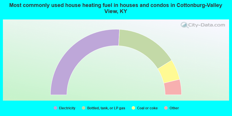
- 51.7%Electricity
- 30.6%Bottled, tank, or LP gas
- 10.1%Coal or coke
- 3.7%Wood
- 2.5%Utility gas
- 1.4%Other fuel
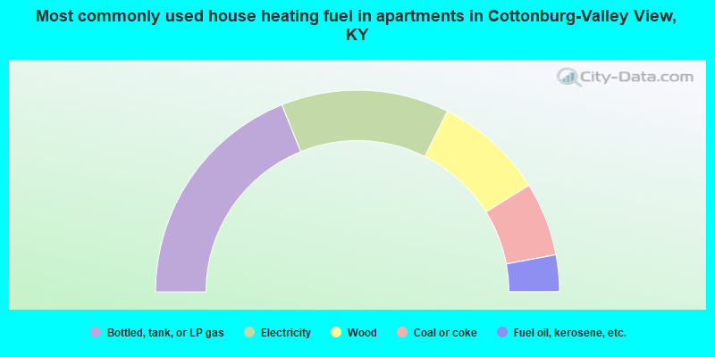
- 37.8%Bottled, tank, or LP gas
- 26.9%Electricity
- 17.6%Wood
- 11.8%Coal or coke
- 5.9%Fuel oil, kerosene, etc.
Cottonburg-Valley View compared to Kentucky state average:
- Unemployed percentage below state average.
- Black race population percentage significantly below state average.
- Hispanic race population percentage significantly below state average.
- Foreign-born population percentage significantly below state average.
- Length of stay since moving in significantly above state average.
- Number of rooms per house significantly below state average.
- House age significantly below state average.
- Number of college students below state average.