East Wakulla, Florida
Submit your own pictures of this place and show them to the world
- OSM Map
- General Map
- Google Map
- MSN Map

| Males: 12,063 | |
| Females: 11,033 |
| Median resident age: | 35.9 years |
| Florida median age: | 38.7 years |
Zip code: 32327
| East Wakulla: | $77,696 |
| FL: | $69,303 |
Estimated per capita income in 2022: $32,838 (it was $17,673 in 2000)
East Wakulla CCD income, earnings, and wages data
Estimated median house or condo value in 2022: $242,479 (it was $80,500 in 2000)
| East Wakulla: | $242,479 |
| FL: | $354,100 |
Detailed information about poverty and poor residents in East Wakulla, FL


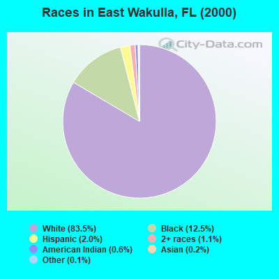
- 14,66583.5%White alone
- 2,19212.5%Black alone
- 3432.0%Hispanic
- 1891.1%Two or more races
- 1020.6%American Indian alone
- 420.2%Asian alone
- 180.1%Other race alone
- 40.02%Native Hawaiian and Other
Pacific Islander alone
Races in East Wakulla detailed stats: ancestries, foreign born residents, place of birth
 Recent articles from our blog. Our writers, many of them Ph.D. graduates or candidates, create easy-to-read articles on a wide variety of topics.
Current Local Time: EST time zone
Land area: 296.8 square miles.
Population density: 78 people per square mile (very low).

| East Wakulla CCD: | 0.9% ($716) |
| Florida: | 1.4% ($1,262) |
Nearest city with pop. 50,000+: Tallahassee, FL  (17.3 miles , pop. 150,624).
Nearest city with pop. 200,000+: Jacksonville, FL (157.0 miles , pop. 735,617).
Nearest city with pop. 1,000,000+: Houston, TX (665.4 miles , pop. 1,953,631).
Nearest cities:
), ), ), ), ), )Latitude: 30.20 N, Longitude: 84.28 W
Area code commonly used in this area: 850

| Here: | 2.8% |
| Florida: | 2.9% |
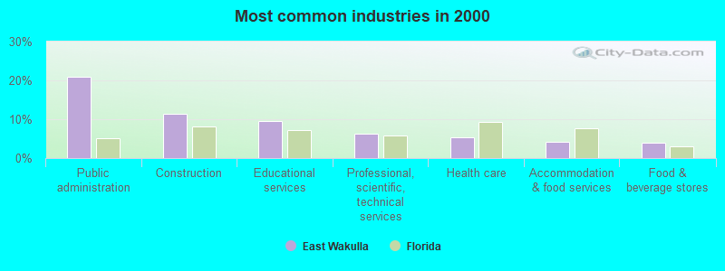
- Public administration (20.9%)
- Construction (11.5%)
- Educational services (9.5%)
- Professional, scientific, technical services (6.2%)
- Health care (5.3%)
- Accommodation & food services (4.1%)
- Food & beverage stores (4.0%)
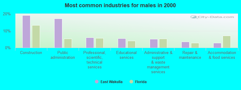
- Construction (19.0%)
- Public administration (17.1%)
- Professional, scientific, technical services (6.0%)
- Educational services (5.5%)
- Administrative & support & waste management services (5.2%)
- Repair & maintenance (3.6%)
- Accommodation & food services (2.8%)
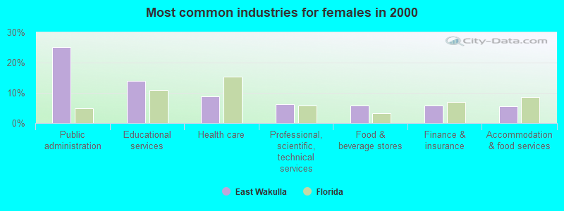
- Public administration (25.0%)
- Educational services (13.8%)
- Health care (8.7%)
- Professional, scientific, technical services (6.4%)
- Food & beverage stores (5.9%)
- Finance & insurance (5.7%)
- Accommodation & food services (5.6%)
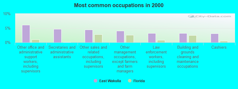
- Other office and administrative support workers, including supervisors (6.1%)
- Secretaries and administrative assistants (4.6%)
- Other sales and related occupations, including supervisors (4.4%)
- Other management occupations, except farmers and farm managers (4.0%)
- Law enforcement workers, including supervisors (3.2%)
- Building and grounds cleaning and maintenance occupations (3.2%)
- Cashiers (3.0%)
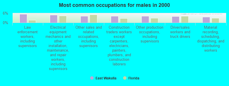
- Law enforcement workers, including supervisors (5.4%)
- Electrical equipment mechanics and other installation, maintenance, and repair workers, including supervisors (5.0%)
- Other sales and related occupations, including supervisors (4.3%)
- Construction traders workers except carpenters, electricians, painters, plumbers, and construction laborers (4.2%)
- Other production occupations, including supervisors (4.1%)
- Driver/sales workers and truck drivers (4.1%)
- Material recording, scheduling, dispatching, and distributing workers (3.6%)
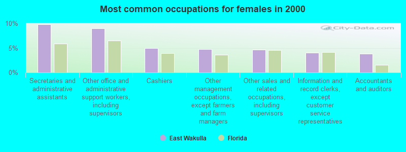
- Secretaries and administrative assistants (9.8%)
- Other office and administrative support workers, including supervisors (8.9%)
- Cashiers (4.9%)
- Other management occupations, except farmers and farm managers (4.8%)
- Other sales and related occupations, including supervisors (4.6%)
- Information and record clerks, except customer service representatives (4.0%)
- Accountants and auditors (3.8%)
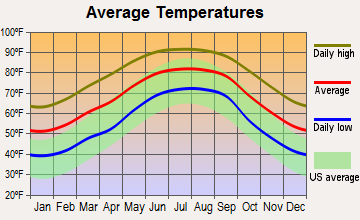
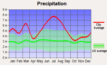
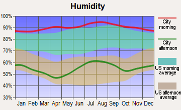
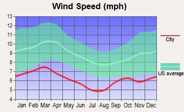
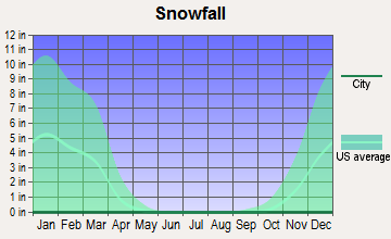
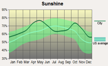
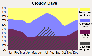
Average climate in East Wakulla, Florida
Based on data reported by over 4,000 weather stations
(lower is better)
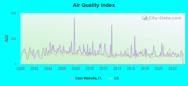
Air Quality Index (AQI) level in 2022 was 71.6. This is about average.
| City: | 71.6 |
| U.S.: | 72.6 |
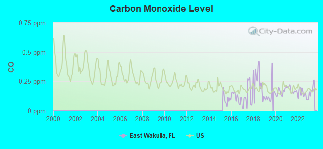
Carbon Monoxide (CO) [ppm] level in 2022 was 0.139. This is significantly better than average. Closest monitor was 10.5 miles away from the city center.
| City: | 0.139 |
| U.S.: | 0.251 |
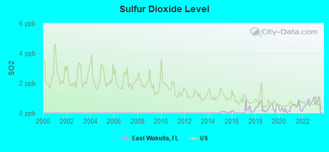
Sulfur Dioxide (SO2) [ppb] level in 2022 was 0.631. This is significantly better than average. Closest monitor was 10.5 miles away from the city center.
| City: | 0.631 |
| U.S.: | 1.515 |
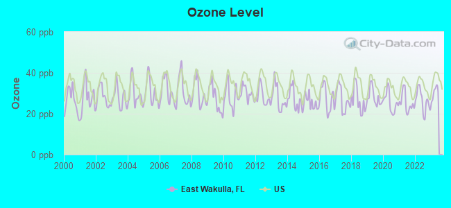
Ozone [ppb] level in 2022 was 26.3. This is better than average. Closest monitor was 10.5 miles away from the city center.
| City: | 26.3 |
| U.S.: | 33.3 |
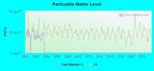
Particulate Matter (PM10) [µg/m3] level in 2003 was 16.4. This is about average. Closest monitor was 11.0 miles away from the city center.
| City: | 16.4 |
| U.S.: | 19.2 |
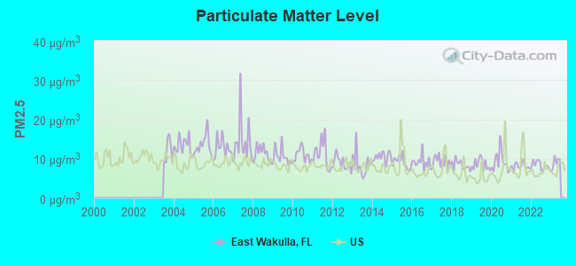
Particulate Matter (PM2.5) [µg/m3] level in 2022 was 8.25. This is about average. Closest monitor was 16.9 miles away from the city center.
| City: | 8.25 |
| U.S.: | 8.11 |
Tornado activity:
East Wakulla-area historical tornado activity is slightly below Florida state average. It is 17% smaller than the overall U.S. average.
On 4/25/1964, a category F2 (max. wind speeds 113-157 mph) tornado 13.2 miles away from the East Wakulla place center injured 2 people and caused between $50,000 and $500,000 in damages.
On 3/28/1972, a category F2 tornado 14.0 miles away from the place center caused between $5000 and $50,000 in damages.
Earthquake activity:
East Wakulla-area historical earthquake activity is significantly above Florida state average. It is 75% smaller than the overall U.S. average.On 9/10/2006 at 14:56:08, a magnitude 5.9 (5.9 MB, 5.5 MS, 5.8 MW, Class: Moderate, Intensity: VI - VII) earthquake occurred 308.4 miles away from the city center
On 10/24/1997 at 08:35:17, a magnitude 4.9 (4.8 MB, 4.2 MS, 4.9 LG, Depth: 6.2 mi, Class: Light, Intensity: IV - V) earthquake occurred 188.9 miles away from the city center
On 8/2/1974 at 08:52:09, a magnitude 4.9 (4.3 MB, 4.9 LG) earthquake occurred 274.9 miles away from East Wakulla center
On 1/18/1999 at 07:00:53, a magnitude 4.8 (4.8 MB, 4.0 LG, Depth: 0.6 mi) earthquake occurred 282.1 miles away from East Wakulla center
On 4/29/2003 at 08:59:39, a magnitude 4.9 (4.4 MB, 4.6 MW, 4.9 LG) earthquake occurred 307.1 miles away from East Wakulla center
On 11/22/1974 at 05:25:55, a magnitude 4.7 (4.7 MB) earthquake occurred 307.1 miles away from the city center
Magnitude types: regional Lg-wave magnitude (LG), body-wave magnitude (MB), surface-wave magnitude (MS), moment magnitude (MW)
Natural disasters:
The number of natural disasters in Wakulla County (27) is a lot greater than the US average (15).Major Disasters (Presidential) Declared: 19
Emergencies Declared: 4
Causes of natural disasters: Hurricanes: 13, Tropical Storms: 7, Floods: 4, Fires: 3, Storms: 2, Tornadoes: 2, Winds: 2, Freeze: 1, Other: 1 (Note: some incidents may be assigned to more than one category).
Hospitals and medical centers near East Wakulla:
- EDEN SPRINGS NURSING AND REHAB CENTER (Nursing Home, about 9 miles away; CRAWFORDVILLE, FL)
- NHC HOMECARE (Home Health Center, about 10 miles away; CRAWFORDVILLE, FL)
- TALLAHASSEE SOUTH DIALYSIS (Dialysis Facility, about 16 miles away; TALLAHASSEE, FL)
- FAITH HOME HEALTH INC (Home Health Center, about 16 miles away; TALLAHASSEE, FL)
Colleges/universities with over 2000 students nearest to East Wakulla:
- Florida Agricultural and Mechanical University (about 16 miles; Tallahassee, FL; Full-time enrollment: 10,841)
- Florida State University (about 17 miles; Tallahassee, FL; FT enrollment: 38,283)
- Tallahassee Community College (about 18 miles; Tallahassee, FL; FT enrollment: 10,904)
- Bainbridge State College (about 51 miles; Bainbridge, GA; FT enrollment: 2,308)
- Wiregrass Georgia Technical College (about 74 miles; Valdosta, GA; FT enrollment: 3,246)
- Valdosta State University (about 75 miles; Valdosta, GA; FT enrollment: 11,155)
- Gulf Coast State College (about 87 miles; Panama City, FL; FT enrollment: 4,474)
Points of interest:
Notable locations in East Wakulla: Old Fort Saint Marks (A), Strickland Landing (B), Fig Tree Landing (C), Newport Station (D), West Goose Creek Seine Yard (E), Wakulla Ranger District Office (F), Wakulla County Ambulance Service (G), Crawfordville Volunteer Fire Department (H), Wakulla Station Volunteer Fire Department (I), Saint Marks Volunteer Fire Department (J), Apalachee Bay Volunteer Fire Department (K), River Sink Volunteer Fire Department (L). Display/hide their locations on the map
Churches in East Wakulla include: Pinewood Church (A), Thessalonia Missionary Church (B), Shady Sea Church (C), Salem Church (D), Saint Pauls Church (E), Pilgrims Rest Church (F), The Church of Jesus Christ of Latter Day Saints-Crawfordville (G), Mount Olive Primitive Baptist Church (H), Medart Assembly of God Church (I). Display/hide their locations on the map
Cemeteries: Magnolia Cemetery (1), Richardson Cemetery (2), Sutton Cemetery (3), Harvey Cemetery (4), Smith Cemetery (5), Raher Cemetery (6), Duggar Cemetery (7). Display/hide their locations on the map
Lakes, reservoirs, and swamps: Spectacle Pond (A), Whiddon Lake (B), Oak Pond (C), Lighthouse Pool (D), Gibbs Pond (E), Mounds Pond (F), Picnic Pond (G), Mounds Pool (H). Display/hide their locations on the map
Streams, rivers, and creeks: Saint Marks River (A), Moriah Creek (B), Big Boggy Branch (C), Wakulla River (D), Spring Creek (E), Red Fish Creek (F), Rock Creek (G), Old Creek (H), Mensler Creek (I). Display/hide their locations on the map
Parks in East Wakulla include: Saint Marks National Wildlife Refuge (1), Edward Ball Wakulla Springs State Park (2), San Marcos De Apalache Historic State Park (3). Display/hide their locations on the map
| This place: | 2.6 people |
| Florida: | 2.5 people |
| This place: | 73.7% |
| Whole state: | 65.2% |
| This place: | 8.0% |
| Whole state: | 7.3% |
Likely homosexual households (counted as self-reported same-sex unmarried-partner households)
- Lesbian couples: 0.4% of all households
- Gay men: 0.2% of all households
| This place: | 10.8% |
| Whole state: | 12.5% |
| This place: | 4.6% |
| Whole state: | 5.7% |
People in group quarters in East Wakulla in 2010:
- 3,284 people in state prisons
- 122 people in local jails and other municipal confinement facilities
- 18 people in emergency and transitional shelters (with sleeping facilities) for people experiencing homelessness
- 4 people in workers' group living quarters and job corps centers
People in group quarters in East Wakulla in 2000:
- 869 people in state prisons
- 155 people in local jails and other confinement facilities (including police lockups)
- 90 people in nursing homes
- 30 people in other noninstitutional group quarters
For population 15 years and over in East Wakulla:
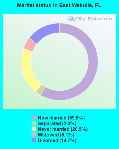
- Never married: 20.5%
- Now married: 59.6%
- Separated: 2.4%
- Widowed: 5.1%
- Divorced: 14.7%
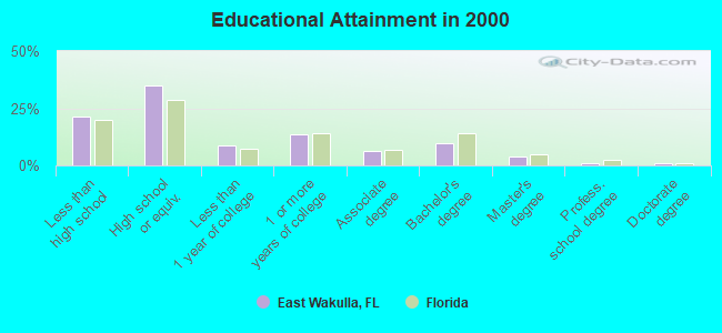
For population 25 years and over in East Wakulla:
- High school or higher: 78.9%
- Bachelor's degree or higher: 15.3%
- Graduate or professional degree: 5.8%
- Unemployed: 3.7%
- Mean travel time to work (commute): 34.7 minutes
| Here: | 10.9 |
| Florida average: | 12.6 |
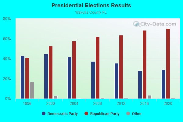
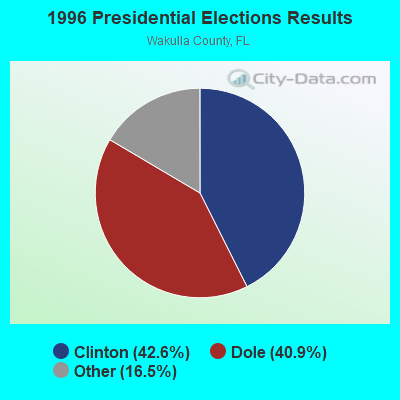
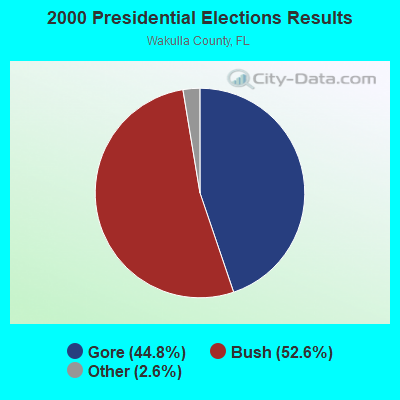
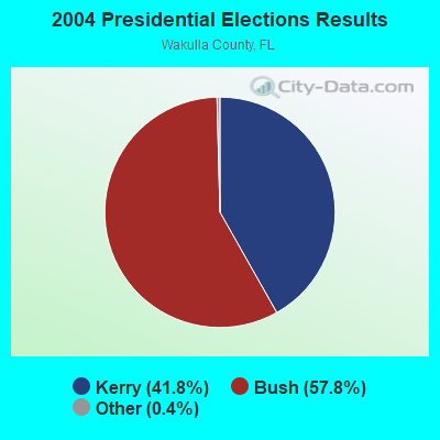
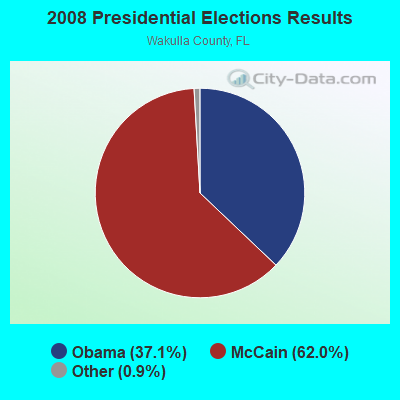

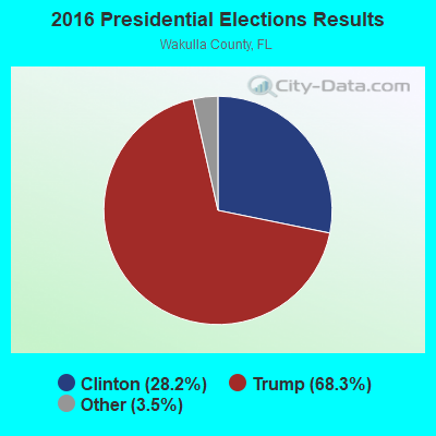
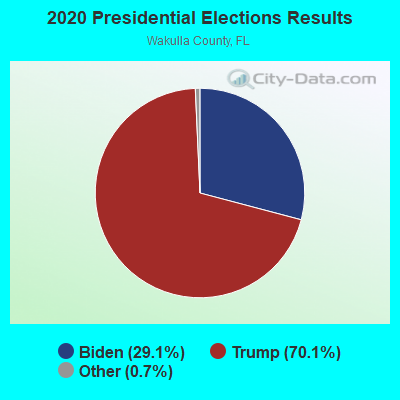
Graphs represent county-level data. Detailed 2008 Election Results
Religion statistics for East Wakulla, FL (based on Wakulla County data)
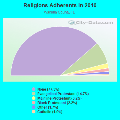
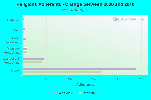
| Religion | Adherents | Congregations |
|---|---|---|
| Evangelical Protestant | 4,514 | 32 |
| Mainline Protestant | 985 | 4 |
| Black Protestant | 664 | 4 |
| Other | 509 | 3 |
| Catholic | 300 | 1 |
| None | 23,804 | - |
Food Environment Statistics:
| This county: | 1.33 / 10,000 pop. |
| Florida: | 2.04 / 10,000 pop. |
| Wakulla County: | 0.33 / 10,000 pop. |
| State: | 1.28 / 10,000 pop. |
| Wakulla County: | 4.32 / 10,000 pop. |
| Florida: | 3.04 / 10,000 pop. |
| Wakulla County: | 5.32 / 10,000 pop. |
| Florida: | 7.45 / 10,000 pop. |
| Wakulla County: | 9.3% |
| State: | 9.2% |
| Wakulla County: | 28.9% |
| Florida: | 23.7% |
| This county: | 11.7% |
| Florida: | 14.0% |
Strongest AM radio stations in East Wakulla:
- WFRF (1070 AM; daytime; 10 kW; TALLAHASSEE, FL; Owner: FAITH RADIO NETWORK, INC.)
- WSTT (730 AM; 25 kW; THOMASVILLE, GA; Owner: MARION R. WILLIAMS)
- WNLS (1270 AM; 5 kW; TALLAHASSEE, FL; Owner: CLEAR CHANNEL BROADCASTING LICENSES, INC.)
- WCVC (1330 AM; daytime; 5 kW; TALLAHASSEE, FL)
- WHBT (1410 AM; 5 kW; TALLAHASSEE, FL)
- WFVR (910 AM; 50 kW; VALDOSTA, GA; Owner: RAMA COMMUNICATIONS, INC.)
- WHGH (840 AM; daytime; 10 kW; THOMASVILLE, GA; Owner: H. G. H INVESTMENT CORP.)
- WJEP (1020 AM; daytime; 10 kW; OCHLOCKNEE, GA; Owner: LIFELINE MINISTRIES, INCORPORATED)
- WOKV (690 AM; 50 kW; JACKSONVILLE, FL; Owner: COX RADIO, INC.)
- WTCL (1580 AM; daytime; 10 kW; CHATTAHOOCHEE, FL; Owner: METZ, INC.)
- WTAL (1450 AM; 1 kW; TALLAHASSEE, FL; Owner: LIVE COMMUNICATIONS, INC.)
- WFLF (540 AM; 50 kW; PINE HILLS, FL; Owner: CLEAR CHANNEL BROADCASTING LICENSES, INC.)
- WYBT (1000 AM; daytime; 5 kW; BLOUNTSTOWN, FL; Owner: BLOUNTSTOWN COMMUNICATIONS, INC.)
Strongest FM radio stations in East Wakulla:
- WHBX (96.1 FM; TALLAHASSEE, FL; Owner: CUMULUS LICENSING CORP.)
- WAKU (94.1 FM; CRAWFORDVILLE, FL; Owner: ALTRUA INVESTMENTS INTERNATIONAL COR)
- WWLD (102.3 FM; CAIRO, GA; Owner: CUMULUS LICENSING CORP.)
- WGLF (104.1 FM; TALLAHASSEE, FL; Owner: CUMULUS LICENSING CORP.)
- WFSQ (91.5 FM; TALLAHASSEE, FL; Owner: FLORIDA STATE UNIVERSITY)
- WBZE (98.9 FM; TALLAHASSEE, FL; Owner: CUMULUS LICENSING CORP.)
- WUTL (106.1 FM; TALLAHASSEE, FL; Owner: MONTEREY LICENSES, LLC)
- WTNT-FM (94.9 FM; TALLAHASSEE, FL; Owner: CLEAR CHANNEL BROADCASTING LICENSES, INC.)
- WTLY (107.1 FM; THOMASVILLE, GA; Owner: CLEAR CHANNEL BROADCASTING LICENSES, INC.)
- WKVH (91.9 FM; MONTICELLO, FL; Owner: EDUCATIONAL MEDIA FOUNDATION)
- WAIB (103.1 FM; TALLAHASSEE, FL; Owner: MONTEREY LICENSES, LLC)
- WFSU-FM (88.9 FM; TALLAHASSEE, FL; Owner: FLORIDA STATE UNIVERSITY)
- WEGT (99.9 FM; LAFAYETTE, FL; Owner: MONTEREY LICENSES, LLC)
- WXSR (101.5 FM; QUINCY, FL; Owner: CLEAR CHANNEL BROADCASTING LICENSES, INC.)
- W250AF (97.9 FM; TALLAHASSEE, FL; Owner: TEMPLE BAPTIST CHURCH, INC.)
- WHTF (104.9 FM; HAVANA, FL; Owner: MONTEREY LICENSES, LLC)
- WBWT (100.7 FM; MIDWAY, FL; Owner: CLEAR CHANNEL BROADCASTING LICENSES, INC.)
- WGWD (93.3 FM; GRETNA, FL; Owner: DE-COL INCORPORATED)
- W224AT (92.7 FM; TALLAHASSEE, FL; Owner: THE BD OF REGENTS OF FLORIDA STATE)
- WANM (90.5 FM; TALLAHASSEE, FL; Owner: FLORIDA A & M UNIVERSITY)
TV broadcast stations around East Wakulla:
- WTXL-TV (Channel 27; TALLAHASSEE, FL; Owner: MEDIA VENTURE MANAGEMENT, INC.)
- WFSU-TV (Channel 11; TALLAHASSEE, FL; Owner: FLORIDA STATE UNIVERSITY)
- WVUP-CA (Channel 45; TALLAHASSEE, FL; Owner: CHRISTIAN TELEVISION CORPORATION, INC.)
- WTBC-LP (Channel 65; TALLAHASSEE, FL; Owner: TEMPLE BAPTIST CHURCH, INC.)
- WTWC-TV (Channel 40; TALLAHASSEE, FL; Owner: WTWC LICENSEE, LLC)
- WCTV (Channel 6; THOMASVILLE, GA; Owner: WCTV LICENSEE CORP.)
- WTLH (Channel 49; BAINBRIDGE, GA; Owner: WTLH LICENSE CORP.)
- W35BN (Channel 35; TALLAHASSEE, FL; Owner: DEEPAK VISWANATH)
- WBXT-CA (Channel 56; TALLAHASSEE, FL; Owner: THE BOX WORLDWIDE LLC)
- WWWF-LP (Channel 47; TALLAHASSEE, FL; Owner: TIGER EYE BROADCASTING CORPORATION)
- W21BK (Channel 21; TALLAHASSEE, FL; Owner: JOSEPH W. SHAFFER)
- WACX-LP (Channel 9; TALLAHASSEE, FL; Owner: ASSOCIATED CHRISTIAN TELEVISION SYSTEM, INC.)
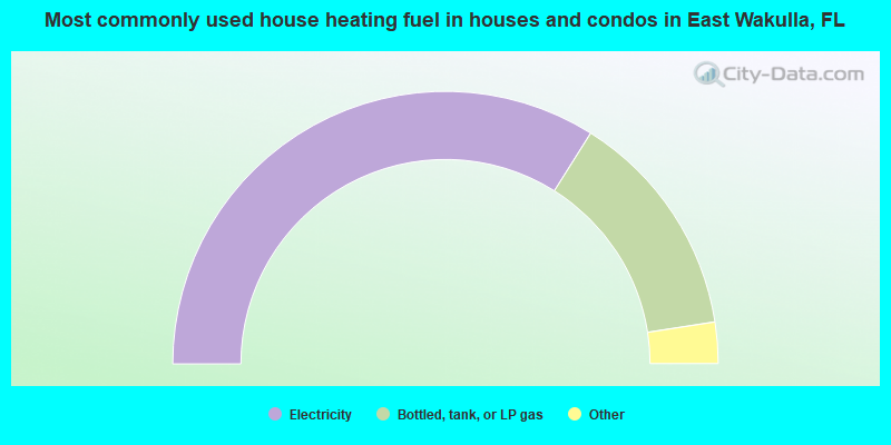
- 67.8%Electricity
- 27.2%Bottled, tank, or LP gas
- 2.1%Wood
- 1.7%Utility gas
- 0.8%No fuel used
- 0.2%Fuel oil, kerosene, etc.
- 0.2%Other fuel
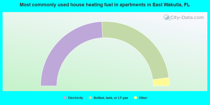
- 48.4%Electricity
- 47.5%Bottled, tank, or LP gas
- 2.0%Fuel oil, kerosene, etc.
- 1.7%Utility gas
- 0.4%Wood
East Wakulla compared to Florida state average:
- Unemployed percentage significantly below state average.
- Hispanic race population percentage significantly below state average.
- Median age below state average.
- Foreign-born population percentage significantly below state average.
- Renting percentage below state average.
- Length of stay since moving in significantly above state average.
- Number of rooms per house significantly below state average.
- House age significantly below state average.
- Institutionalized population percentage significantly above state average.
- Percentage of population with a bachelor's degree or higher below state average.
East Wakulla on our top lists:
- #20 on the list of "Top 101 cities with largest percentage of females in industries: public administration (population 5,000+)"
- #21 on the list of "Top 101 cities with largest percentage of males in occupations: occupational and physical therapist assistants and aides (population 5,000+)"
- #23 on the list of "Top 101 cities with largest percentage of females in occupations: fishing and hunting, and forest and logging workers (population 5,000+)"
- #24 on the list of "Top 101 cities with largest percentage of females in occupations: accountants and auditors (population 5,000+)"
- #42 on the list of "Top 101 cities with largest percentage of females in occupations: air transportation workers (population 5,000+)"
- #42 on the list of "Top 101 cities with largest percentage of females in occupations: bus drivers (population 5,000+)"
- #56 on the list of "Top 101 cities with largest percentage of males in industries: u. s. postal service (population 5,000+)"
- #64 on the list of "Top 101 cities with largest percentage of females in industries: food and beverage stores (population 5,000+)"
- #67 on the list of "Top 101 cities with largest percentage of males in occupations: painters and paperhangers (population 5,000+)"
- #88 on the list of "Top 101 cities with the largest percentage of mobile homes (2,000+ housing units)"
- #99 on the list of "Top 101 cities with largest percentage of males in industries: petroleum and petroleum products merchant wholesalers (population 5,000+)"