Dover, Vermont
Submit your own pictures of this town and show them to the world
- OSM Map
- General Map
- Google Map
- MSN Map
Population change since 2000: -20.3%
| Males: 585 | |
| Females: 539 |
| Median resident age: | 49.3 years |
| Vermont median age: | 45.8 years |
Zip codes: 05341.
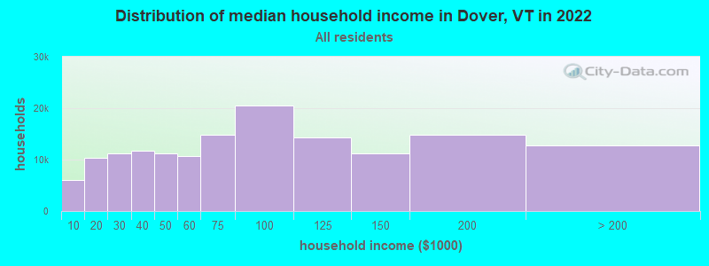
| Dover: | $75,081 |
| VT: | $73,991 |
Estimated per capita income in 2022: $46,707 (it was $23,485 in 2000)
Dover town income, earnings, and wages data
Estimated median house or condo value in 2022: $356,521 (it was $143,300 in 2000)
| Dover: | $356,521 |
| VT: | $304,700 |
Mean prices in 2022: all housing units: $298,935; detached houses: $317,292; townhouses or other attached units: $299,018; in 2-unit structures: $292,940; in 3-to-4-unit structures: $427,770; in 5-or-more-unit structures: $214,034; mobile homes: $65,502
Detailed information about poverty and poor residents in Dover, VT
Compare current foreclosures near Dover, VT:
| Photo | Address | Area | Beds / Baths | Price | Details |
|---|---|---|---|---|---|

|
#1
Chapel Rd
Bennington, VT 05201
|
1,000 sq. feet
|
1 baths 2 beds |
$273,000
|
show details |

|
#2
Pine St
Brattleboro, VT 05301
|
2,906 sq. feet
|
2 baths 5 beds |
show details | |

|
#3
Dover Rd
South Newfane, VT 05351
|
- sq. feet
|
- baths - beds |
show details | |

|
#4
Dover Rd
Williamsville, VT 05362
|
- sq. feet
|
- baths - beds |
show details | |

|
#5
Old Cyrus Stage Rd
Rowe, MA 01367
|
- sq. feet
|
- baths - beds |
show details | |

|
Check over 1 million property listings on Foreclosure.com!
|
browse all offers | |||

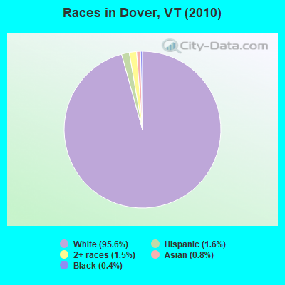
- 1,07495.6%White alone
- 181.6%Hispanic
- 171.5%Two or more races
- 90.8%Asian alone
- 50.4%Black alone
- 10.09%Other race alone
Races in Dover detailed stats: ancestries, foreign born residents, place of birth
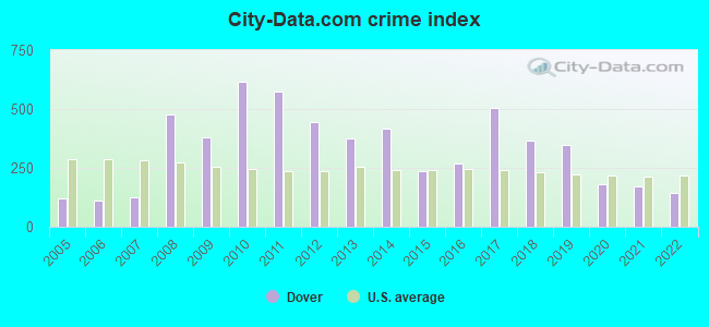
Type |
2009 |
2010 |
2011 |
2012 |
2013 |
2014 |
2015 |
2016 |
2017 |
2018 |
2019 |
2020 |
2021 |
2022 |
|---|---|---|---|---|---|---|---|---|---|---|---|---|---|---|
| Murders (per 100,000) | 0 (0.0) | 0 (0.0) | 0 (0.0) | 0 (0.0) | 0 (0.0) | 0 (0.0) | 0 (0.0) | 0 (0.0) | 0 (0.0) | 0 (0.0) | 0 (0.0) | 0 (0.0) | 0 (0.0) | 0 (0.0) |
| Rapes (per 100,000) | 0 (0.0) | 0 (0.0) | 0 (0.0) | 0 (0.0) | 0 (0.0) | 0 (0.0) | 0 (0.0) | 0 (0.0) | 0 (0.0) | 1 (94.6) | 0 (0.0) | 0 (0.0) | 0 (0.0) | 1 (53.8) |
| Robberies (per 100,000) | 0 (0.0) | 0 (0.0) | 1 (88.9) | 0 (0.0) | 0 (0.0) | 0 (0.0) | 0 (0.0) | 0 (0.0) | 0 (0.0) | 0 (0.0) | 0 (0.0) | 0 (0.0) | 0 (0.0) | 0 (0.0) |
| Assaults (per 100,000) | 0 (0.0) | 0 (0.0) | 1 (88.9) | 1 (89.6) | 1 (90.1) | 4 (360.0) | 2 (181.2) | 1 (91.3) | 5 (464.7) | 4 (378.4) | 3 (283.8) | 1 (95.1) | 3 (285.4) | 2 (107.6) |
| Burglaries (per 100,000) | 13 (906.6) | 19 (1,690) | 13 (1,156) | 25 (2,240) | 15 (1,351) | 14 (1,260) | 5 (452.9) | 6 (547.9) | 7 (650.6) | 6 (567.6) | 2 (189.2) | 5 (475.3) | 1 (95.1) | 0 (0.0) |
| Thefts (per 100,000) | 112 (7,810) | 128 (11,388) | 120 (10,667) | 75 (6,720) | 71 (6,396) | 71 (6,391) | 47 (4,257) | 58 (5,297) | 96 (8,922) | 46 (4,352) | 71 (6,717) | 30 (2,852) | 26 (2,474) | 30 (1,614) |
| Auto thefts (per 100,000) | 1 (69.7) | 6 (533.8) | 3 (266.7) | 0 (0.0) | 1 (90.1) | 0 (0.0) | 0 (0.0) | 0 (0.0) | 1 (92.9) | 0 (0.0) | 1 (94.6) | 2 (190.1) | 1 (95.1) | 3 (161.4) |
| Arson (per 100,000) | 0 (0.0) | 0 (0.0) | 0 (0.0) | 0 (0.0) | 0 (0.0) | 1 (90.0) | 0 (0.0) | 0 (0.0) | 0 (0.0) | 0 (0.0) | 0 (0.0) | 0 (0.0) | 0 (0.0) | 0 (0.0) |
| City-Data.com crime index | 381.5 | 616.5 | 573.3 | 443.5 | 375.7 | 415.8 | 238.2 | 268.5 | 502.8 | 365.2 | 346.3 | 181.6 | 170.3 | 142.0 |
The City-Data.com crime index weighs serious crimes and violent crimes more heavily. Higher means more crime, U.S. average is 246.1. It adjusts for the number of visitors and daily workers commuting into cities.
Crime rate in Dover detailed stats: murders, rapes, robberies, assaults, burglaries, thefts, arson
Full-time law enforcement employees in 2021, including police officers: 7 (6 officers - 5 male; 1 female).
| Officers per 1,000 residents here: | 5.71 |
| Vermont average: | 1.69 |
 Recent articles from our blog. Our writers, many of them Ph.D. graduates or candidates, create easy-to-read articles on a wide variety of topics.

 | Vacation in Vermont (15 replies) |
| Dover and Wilmington (2 replies) |
| Official Vermont Picture Thread (966 replies) |
| Putney/Dummerston/Bratt/Keene (18 replies) |
| Dover or Wilmington (14 replies) |
| Public transportation - Mt. Snow/W.Dover to Burlington (4 replies) |
Latest news from Dover, VT collected exclusively by city-data.com from local newspapers, TV, and radio stations
Ancestries: Irish (19.4%), English (17.0%), German (15.1%), Italian (9.0%), United States (8.7%), French (8.7%).
Current Local Time: EST time zone
Elevation: 1893 feet
Land area: 35.3 square miles.
Population density: 32 people per square mile (very low).
48 residents are foreign born (1.8% Europe, 0.8% Latin America, 0.5% North America).
| This town: | 3.4% |
| Vermont: | 3.8% |
| Dover town: | 1.1% ($1,564) |
| Vermont: | 2.0% ($2,196) |
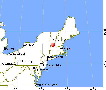
Nearest city with pop. 50,000+: Albany, NY  (51.4 miles , pop. 95,658).
Nearest city with pop. 200,000+: Boston, MA (99.9 miles , pop. 589,141).
Nearest city with pop. 1,000,000+: Bronx, NY (155.1 miles , pop. 1,332,650).
Nearest cities:
), ), )Latitude: 42.96 N, Longitude: 72.85 W
Area code commonly used in this area: 802

Dover tourist attractions:
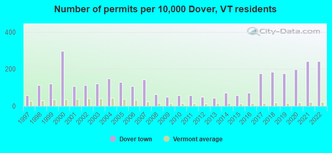
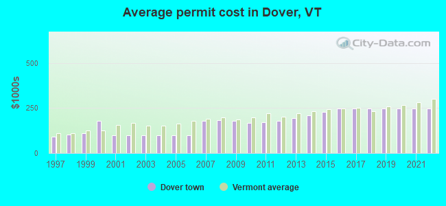
Single-family new house construction building permits:
- 2022: 34 buildings, average cost: $248,100
- 2021: 34 buildings, average cost: $248,100
- 2020: 28 buildings, average cost: $248,100
- 2019: 25 buildings, average cost: $248,100
- 2018: 26 buildings, average cost: $248,100
- 2017: 25 buildings, average cost: $248,100
- 2016: 10 buildings, average cost: $246,000
- 2015: 8 buildings, average cost: $226,800
- 2014: 10 buildings, average cost: $211,200
- 2013: 6 buildings, average cost: $193,300
- 2012: 7 buildings, average cost: $180,800
- 2011: 8 buildings, average cost: $172,000
- 2010: 8 buildings, average cost: $165,900
- 2009: 7 buildings, average cost: $178,900
- 2008: 9 buildings, average cost: $182,300
- 2007: 20 buildings, average cost: $181,200
- 2006: 15 buildings, average cost: $100,000
- 2005: 18 buildings, average cost: $100,000
- 2004: 21 buildings, average cost: $100,000
- 2003: 17 buildings, average cost: $100,000
- 2002: 16 buildings, average cost: $100,000
- 2001: 15 buildings, average cost: $100,000
- 2000: 42 buildings, average cost: $180,600
- 1999: 17 buildings, average cost: $109,200
- 1998: 16 buildings, average cost: $101,700
- 1997: 8 buildings, average cost: $91,700
| Here: | 4.3% |
| Vermont: | 2.0% |
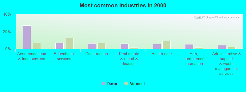
- Accommodation & food services (26.8%)
- Educational services (7.1%)
- Construction (6.4%)
- Real estate & rental & leasing (6.0%)
- Health care (5.6%)
- Arts, entertainment, recreation (5.5%)
- Administrative & support & waste management services (4.3%)
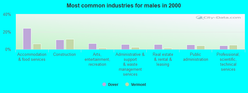
- Accommodation & food services (24.0%)
- Construction (10.8%)
- Arts, entertainment, recreation (6.7%)
- Administrative & support & waste management services (5.6%)
- Real estate & rental & leasing (5.6%)
- Public administration (5.2%)
- Professional, scientific, technical services (4.3%)
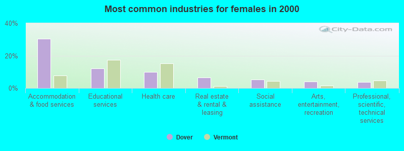
- Accommodation & food services (30.3%)
- Educational services (12.2%)
- Health care (10.0%)
- Real estate & rental & leasing (6.4%)
- Social assistance (5.3%)
- Arts, entertainment, recreation (3.9%)
- Professional, scientific, technical services (3.6%)
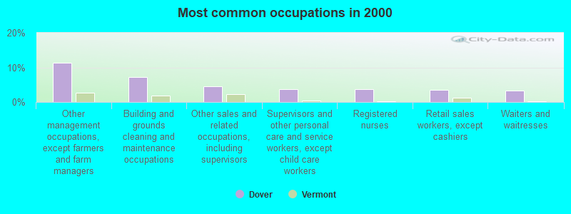
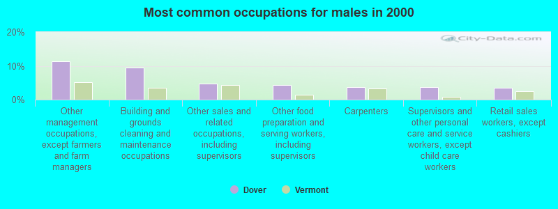
- Other management occupations, except farmers and farm managers (11.3%)
- Building and grounds cleaning and maintenance occupations (7.2%)
- Other sales and related occupations, including supervisors (4.5%)
- Supervisors and other personal care and service workers, except child care workers (3.8%)
- Registered nurses (3.6%)
- Retail sales workers, except cashiers (3.4%)
- Waiters and waitresses (3.3%)
- Other management occupations, except farmers and farm managers (11.3%)
- Building and grounds cleaning and maintenance occupations (9.5%)
- Other sales and related occupations, including supervisors (4.8%)
- Other food preparation and serving workers, including supervisors (4.3%)
- Carpenters (3.7%)
- Supervisors and other personal care and service workers, except child care workers (3.7%)
- Retail sales workers, except cashiers (3.5%)
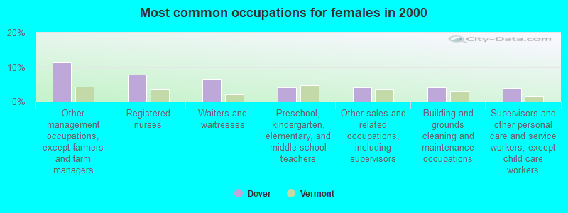
- Other management occupations, except farmers and farm managers (11.4%)
- Registered nurses (7.8%)
- Waiters and waitresses (6.7%)
- Preschool, kindergarten, elementary, and middle school teachers (4.2%)
- Other sales and related occupations, including supervisors (4.2%)
- Building and grounds cleaning and maintenance occupations (4.2%)
- Supervisors and other personal care and service workers, except child care workers (3.9%)
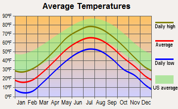
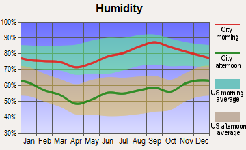
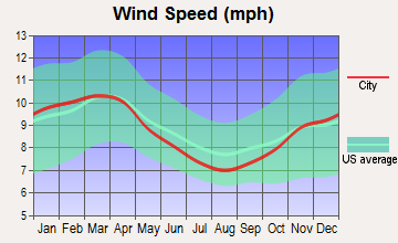
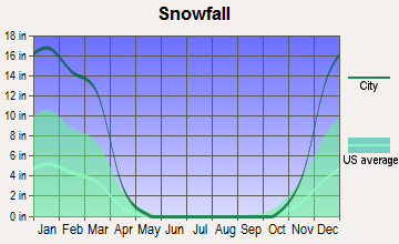
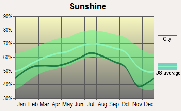
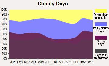
Average climate in Dover, Vermont
Based on data reported by over 4,000 weather stations
(lower is better)
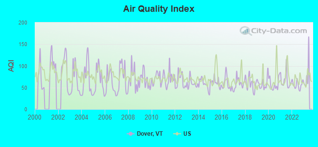
Air Quality Index (AQI) level in 2022 was 56.8. This is better than average.
| City: | 56.8 |
| U.S.: | 72.6 |
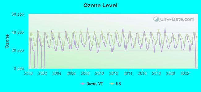
Ozone [ppb] level in 2022 was 29.1. This is about average. Closest monitor was 12.4 miles away from the city center.
| City: | 29.1 |
| U.S.: | 33.3 |
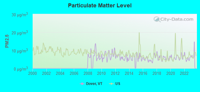
Particulate Matter (PM2.5) [µg/m3] level in 2022 was 5.71. This is significantly better than average. Closest monitor was 17.6 miles away from the city center.
| City: | 5.71 |
| U.S.: | 8.11 |
Tornado activity:
Dover-area historical tornado activity is significantly above Vermont state average. It is 34% smaller than the overall U.S. average.
On 8/20/1968, a category F3 (max. wind speeds 158-206 mph) tornado 10.2 miles away from the Dover town center injured one person and caused between $5000 and $50,000 in damages.
On 5/31/1998, a category F3 tornado 16.7 miles away from the town center injured 68 people and caused $71 million in damages.
Earthquake activity:
Dover-area historical earthquake activity is significantly above Vermont state average. It is 69% smaller than the overall U.S. average.On 10/7/1983 at 10:18:46, a magnitude 5.3 (5.1 MB, 5.3 LG, 5.1 ML, Class: Moderate, Intensity: VI - VII) earthquake occurred 101.7 miles away from the city center
On 4/20/2002 at 10:50:47, a magnitude 5.3 (5.3 ML, Depth: 3.0 mi) earthquake occurred 115.5 miles away from Dover center
On 4/20/2002 at 10:50:47, a magnitude 5.2 (5.2 MB, 4.2 MS, 5.2 MW, 5.0 MW) earthquake occurred 114.3 miles away from Dover center
On 1/19/1982 at 00:14:42, a magnitude 4.7 (4.5 MB, 4.7 MD, 4.5 LG, Class: Light, Intensity: IV - V) earthquake occurred 73.4 miles away from the city center
On 10/16/2012 at 23:12:25, a magnitude 4.7 (4.7 ML, Depth: 10.0 mi) earthquake occurred 119.1 miles away from Dover center
On 6/17/1991 at 08:53:16, a magnitude 4.1 (4.0 MB, 4.0 LG, Depth: 3.1 mi) earthquake occurred 95.4 miles away from Dover center
Magnitude types: regional Lg-wave magnitude (LG), body-wave magnitude (MB), duration magnitude (MD), local magnitude (ML), surface-wave magnitude (MS), moment magnitude (MW)
Natural disasters:
The number of natural disasters in Windham County (16) is near the US average (15).Major Disasters (Presidential) Declared: 13
Emergencies Declared: 2
Causes of natural disasters: Floods: 11, Storms: 10, Tropical Storms: 2, Hurricane: 1, Landslide: 1, Snowstorm: 1, Wind: 1, Winter Storm: 1 (Note: some incidents may be assigned to more than one category).

Colleges/universities with over 2000 students nearest to Dover:
- Williams College (about 25 miles; Williamstown, MA; Full-time enrollment: 2,141)
- Keene State College (about 30 miles; Keene, NH; FT enrollment: 5,098)
- Franklin Pierce University (about 43 miles; Rindge, NH; FT enrollment: 2,139)
- University of Massachusetts-Amherst (about 43 miles; Amherst, MA; FT enrollment: 26,583)
- Rensselaer Polytechnic Institute (about 45 miles; Troy, NY; FT enrollment: 6,940)
- The Sage Colleges (about 46 miles; Troy, NY; FT enrollment: 2,499)
- Smith College (about 46 miles; Northampton, MA; FT enrollment: 3,549)
Public elementary/middle school in Dover:
- DOVER ELEMENTARY SCHOOL (Students: 82, Location: 9 SCHOOLHOUSE ROAD, Grades: PK-6)
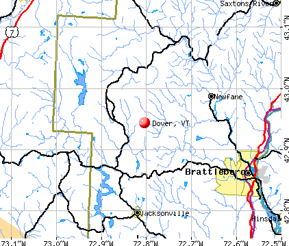
Points of interest:
Notable locations in Dover: Mount Snow Ski Area (A), Carinthia Ski Area (B), Hermitage Touring Center (C), Mount Snow Golf Course (D), Mount Snow Ski Resort (E), Timber Creek Ski Resort (F), Carinthia Ski Center (G), Mount Snow Conference Center (H), Dover Free Library (I), Dover Town Hall (J), Dover Town Offices (K), West Dover Fire Department (L), East Dover Volunteer Fire Company, Incorporated (M). Display/hide their locations on the map
Churches in Dover include: West Dover Congregational Church (A), East Dover Baptist Church (B). Display/hide their locations on the map
Cemeteries: Mountain View Cemetery (1), West Dover Village Cemetery (2), Smead Hill Cemetery (3), Rice-Snow Cemetery (4), Mount View Cemetery (5), East Dover Cemetery (6), Dover Center Cemetery (7). Display/hide their locations on the map
Streams, rivers, and creeks: Taft Brook (A), Cheney Brook (B), Blue Brook (C). Display/hide their locations on the map
Parks in Dover include: West Dover Historic District (1), Dover Common (2). Display/hide their locations on the map
Birthplace of: Kittredge Haskins - Politician.
| This town: | 2.1 people |
| Vermont: | 2.3 people |
| This town: | 58.3% |
| Whole state: | 62.5% |
| This town: | 8.2% |
| Whole state: | 9.2% |
Likely homosexual households (counted as self-reported same-sex unmarried-partner households)
- Lesbian couples: 0.9% of all households
- Gay men: 0.9% of all households
| This town: | 10.0% |
| Whole state: | 9.4% |
| This town: | 3.7% |
| Whole state: | 3.6% |
For population 15 years and over in Dover:
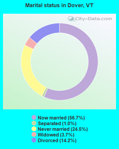
- Never married: 24.5%
- Now married: 56.7%
- Separated: 1.0%
- Widowed: 3.7%
- Divorced: 14.2%
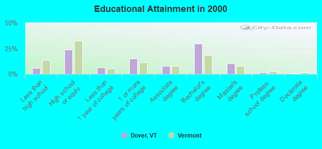
For population 25 years and over in Dover:
- High school or higher: 94.0%
- Bachelor's degree or higher: 41.7%
- Graduate or professional degree: 12.3%
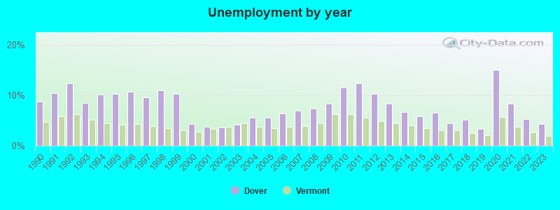
- Unemployed: 3.7%
- Mean travel time to work (commute): 22.4 minutes
| Here: | 9.3 |
| Vermont average: | 11.7 |
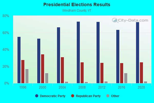
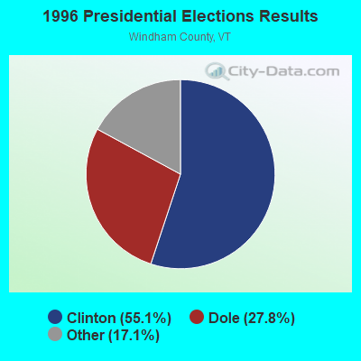
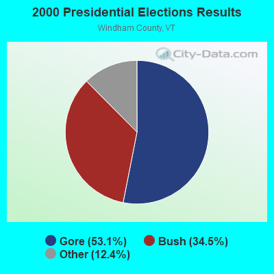
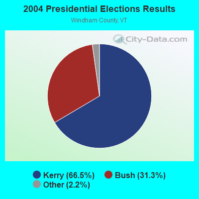
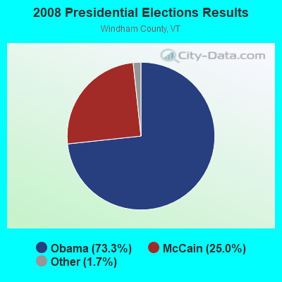

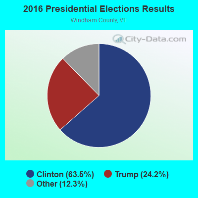
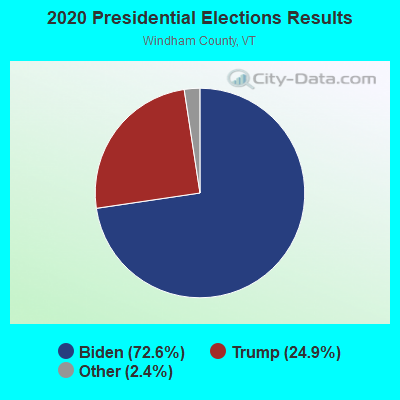
Graphs represent county-level data. Detailed 2008 Election Results
Religion statistics for Dover, VT (based on Windham County data)
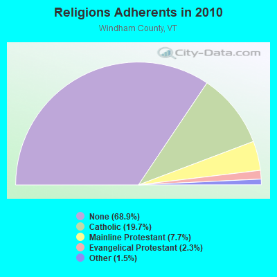
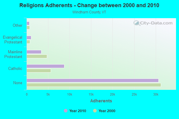
| Religion | Adherents | Congregations |
|---|---|---|
| Catholic | 8,753 | 8 |
| Mainline Protestant | 3,412 | 38 |
| Evangelical Protestant | 1,026 | 13 |
| Other | 647 | 12 |
| None | 30,675 | - |
Food Environment Statistics:
| This county: | 4.14 / 10,000 pop. |
| State: | 3.84 / 10,000 pop. |
| Here: | 1.38 / 10,000 pop. |
| State: | 1.95 / 10,000 pop. |
| This county: | 7.37 / 10,000 pop. |
| Vermont: | 6.40 / 10,000 pop. |
| Here: | 18.87 / 10,000 pop. |
| Vermont: | 11.52 / 10,000 pop. |
| Windham County: | 6.7% |
| State: | 6.8% |
| Here: | 22.6% |
| Vermont: | 22.3% |
| Windham County: | 12.5% |
| State: | 13.3% |
Strongest AM radio stations in Dover:
- WNNZ (640 AM; 50 kW; WESTFIELD, MA; Owner: CLEAR CHANNEL BROADCASTING LICENSES, INC.)
- WGY (810 AM; 50 kW; SCHENECTADY, NY; Owner: CLEAR CHANNEL BROADCASTING LICENSES, INC.)
- WCRN (830 AM; 50 kW; WORCESTER, MA; Owner: CARTER BROADCASTING CORPORATION)
- WPTR (1540 AM; 50 kW; ALBANY, NY; Owner: KIMTRON, INC.)
- WIZZ (1520 AM; daytime; 10 kW; GREENFIELD, MA; Owner: P. & M. RADIO, LLC)
- WRKO (680 AM; 50 kW; BOSTON, MA; Owner: ENTERCOM BOSTON LICENSE, LLC)
- WVNE (760 AM; daytime; 25 kW; LEICESTER, MA; Owner: BLOUNT MASSCOM, INC.)
- WTIC (1080 AM; 50 kW; HARTFORD, CT; Owner: INFINITY RADIO OPERATIONS INC.)
- WEEI (850 AM; 50 kW; BOSTON, MA; Owner: ENTERCOM BOSTON LICENSE, LLC)
- WKOX (1200 AM; 50 kW; FRAMINGHAM, MA; Owner: CAPSTAR TX LIMITED PARTNERSHIP)
- WALE (990 AM; 50 kW; GREENVILLE, RI; Owner: NORTH AMERICAN BROADCASTING CO., INC.)
- WKBK (1290 AM; 5 kW; KEENE, NH; Owner: SAGA COMMUNICATIONS OF NEW ENGLAND, LLC)
- WBIX (1060 AM; 40 kW; NATICK, MA; Owner: LANGER BROADCASTING CORPORATION)
Strongest FM radio stations in Dover:
- WVAY (100.7 FM; WILMINGTON, VT; Owner: GREAT NORTHERN RADIO, L.L.C.)
- WEQX (102.7 FM; MANCHESTER, VT; Owner: NORTHSHIRE COMMUNICATIONS, INC.)
- WJAN (95.1 FM; SUNDERLAND, VT; Owner: 6 JOHNSON ROAD LICENSES, INC.)
- WRSY (101.5 FM; MARLBORO, VT; Owner: GREAT NORTHERN RADIO, L.L.C.)
- WKVT-FM (92.7 FM; BRATTLEBORO, VT; Owner: SAGA COMMUNICATIONS OF NEW ENGLAND, LLC)
- WCMK (91.9 FM; PUTNEY, VT; Owner: CHRISTIAN MINISTRIES INC)
- WAMC-FM (90.3 FM; ALBANY, NY; Owner: WAMC)
- WVPR (89.5 FM; WINDSOR, VT; Owner: VERMONT PUBLIC RADIO)
- WJJR (98.1 FM; RUTLAND, VT; Owner: 6 JOHNSON ROAD LICENSES, INC.)
- WZRT (97.1 FM; RUTLAND, VT; Owner: CAPSTAR TX LIMITED PARTNERSHIP)
- WHDQ (106.1 FM; CLAREMONT, NH; Owner: GREAT NORTHERN RADIO, L.L.C.)
- WEBK (105.3 FM; KILLINGTON, VT; Owner: 6 JOHNSON ROAD LICENSES, INC.)
- WKNE (103.7 FM; KEENE, NH; Owner: SAGA COMMUNICATIONS OF NEW ENGLAND, LLC)
- WGLV (91.7 FM; WOODSTOCK, VT; Owner: CHRISTIAN MINISTRIES INC)
- WHDQ-FM1 (106.1 FM; RUTLAND, VT; Owner: GREAT NORTHERN RADIO, L.L.C.)
- WEVN (90.7 FM; KEENE, NH; Owner: NEW HAMPSHIRE PUBLIC RADIO, INC.)
- WPVQ (95.3 FM; GREENFIELD, MA; Owner: GREAT NORTHERN RADIO, L.L.C.)
- WZEC (97.5 FM; HOOSICK FALLS, NY; Owner: GREAT NORTHERN RADIO, LLC)
- WNGN (91.9 FM; ARGYLE, NY; Owner: NORTHEAST GOSPEL BROADCASTING INC)
- WCFR-FM (96.3 FM; WALPOLE, NH; Owner: GREAT NORTHERN RADIO, LLC)
TV broadcast stations around Dover:
- WEKW-TV (Channel 52; KEENE, NH; Owner: UNIVERSITY OF NEW HAMPSHIRE)
Dover fatal accident list:
Dec 9, 2007 02:51 AM, Sr-100, Lat: 42.945533, Lon: -72.864439, Vehicles: 1, Persons: 2, Pedestrians: 1, Fatalities: 1, Drunk persons involved: 1
Nov 26, 1987 09:45 PM, Th 25, Vehicles: 1, Persons: 3, Fatalities: 1
Jul 9, 1982 06:35 PM, Th42, Vehicles: 2, Persons: 3, Fatalities: 1
Sep 22, 1977 08:27 PM, Vehicles: 1, Persons: 1, Fatalities: 1, Drunk persons involved: 1
- National Bridge Inventory (NBI) Statistics
- 13Number of bridges
- 69ft / 20.7mTotal length
- $4,010,000Total costs
- 19,415Total average daily traffic
- 1,302Total average daily truck traffic
- 20,387Total future (year 2027) average daily traffic
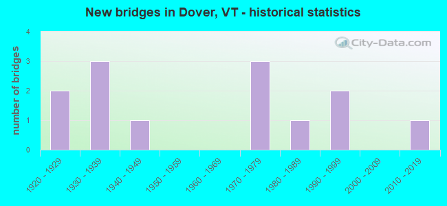
- New bridges - historical statistics
- 21920-1929
- 31930-1939
- 11940-1949
- 31970-1979
- 11980-1989
- 21990-1999
- 12010-2019
FCC Registered Antenna Towers:
1- Jeffrey A Ploof, 19 Rice Hill Rd (Lat: 42.960167 Lon: -72.816278), Type: 37.0, Structure height: 50025 m, Overall height: 37 m, Registrant: Green Mountain Power Corp, Jeff.Ploof@greenmountainpower.Com, , Rutla-nd, Phone: (802) 353-1844
FCC Registered Broadcast Land Mobile Towers:
2- East Dover Fire Station (Lat: 42.954806 Lon: -72.772028), Type: Building, Structure height: 10 m, Overall height: 17 m, Call Sign: WPKG751,
Assigned Frequencies: 154.430 MHz, Grant Date: 12/01/2011, Expiration Date: 02/15/2022, Cancellation Date: 04/23/2022, Certifier: John S Marechal, Registrant: Swnh District Fire Mutual Aid, 32 Vernon Street, Keene, NH 03431, Phone: (603) 352-8635, Fax: (603) 352-1985, Email:
- Dover Rd At Dover Elementary School Entrance (Lat: 42.933417 Lon: -72.799528), Call Sign: KSW986,
Assigned Frequencies: 33.1000 MHz, Grant Date: 09/26/2000, Expiration Date: 11/27/2005, Cancellation Date: 01/08/2002, Registrant: Dover, Town Of, Hwy Dept, West Dover, VT 05356
2006 - 2018 National Fire Incident Reporting System (NFIRS) incidents
- Fire incident types reported to NFIRS in Dover, VT
- 10366.9%Structure Fires
- 3422.1%Outside Fires
- 95.8%Other
- 85.2%Mobile Property/Vehicle Fires
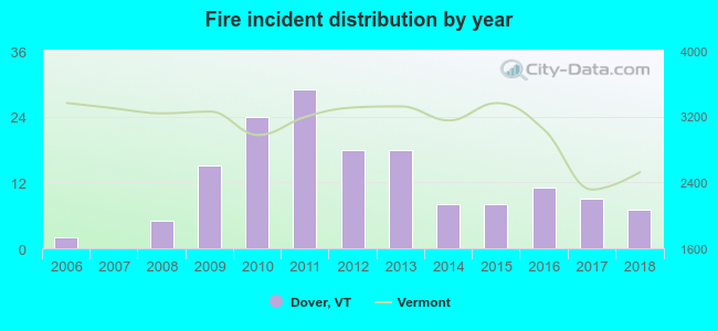 According to the data from the years 2006 - 2018 the average number of fire incidents per year is 12. The highest number of fire incidents - 29 took place in 2011, and the least - 0 in 2007. The data has a growing trend.
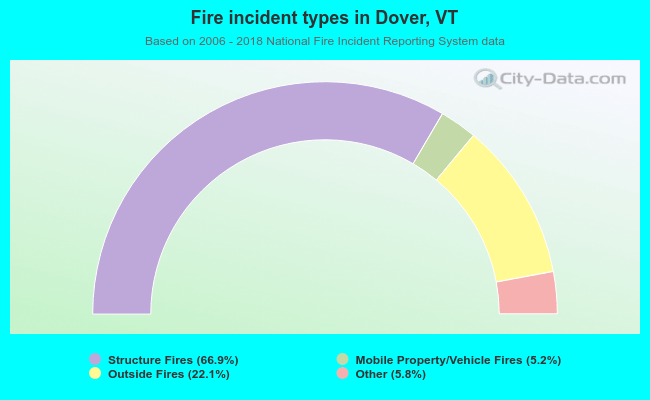 When looking into fire subcategories, the most reports belonged to: Structure Fires (66.9%), and Outside Fires (22.1%).
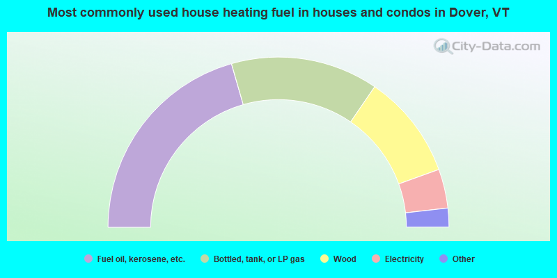
- 41.1%Fuel oil, kerosene, etc.
- 28.0%Bottled, tank, or LP gas
- 19.9%Wood
- 7.4%Electricity
- 2.3%Utility gas
- 0.9%Other fuel
- 0.5%Solar energy
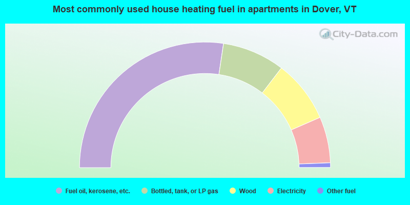
- 54.8%Fuel oil, kerosene, etc.
- 16.1%Bottled, tank, or LP gas
- 16.1%Wood
- 11.9%Electricity
- 1.2%Other fuel
Dover compared to Vermont state average:
- Unemployed percentage significantly below state average.
- Black race population percentage below state average.
- Hispanic race population percentage below state average.
- Length of stay since moving in significantly above state average.
- Number of rooms per house significantly below state average.
- House age significantly below state average.