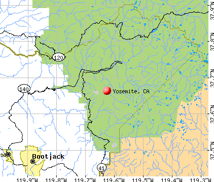
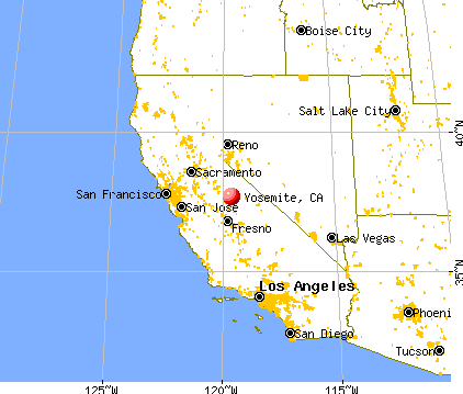
Yosemite, California
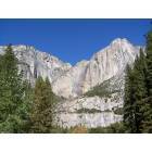
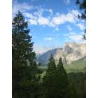
Yosemite: View of Mountains
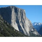
Yosemite: El Capitan
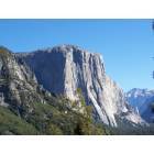
Yosemite: El Capitan, Yosemite, Winter 2008
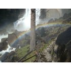
Yosemite: Rainbow on the Mist Tral
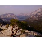
Yosemite: Yosemite High Country - June 2008
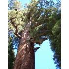
Yosemite: The pine tree
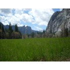
Yosemite: A meadow in Yosemite, National Park
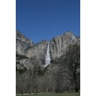
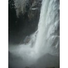
Yosemite: Yosemite Waterfall
Yosemite: Vernal Falls
Yosemite: Grizzly Redwood Tree
- add
your
Submit your own pictures of this place and show them to the world
- OSM Map
- General Map
- Google Map
- MSN Map
| Males: 1,448 | |
| Females: 925 |
| Median resident age: | 34.6 years |
| California median age: | 33.3 years |
Zip code: 95389
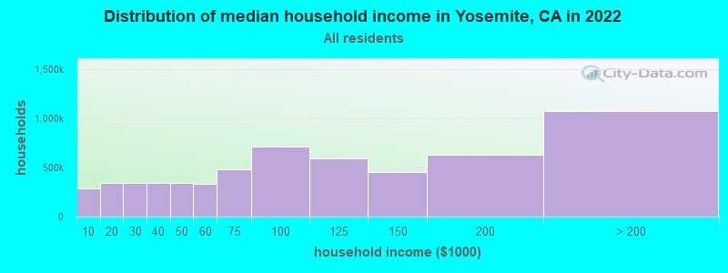
| Yosemite: | $72,240 |
| CA: | $91,551 |
Estimated per capita income in 2022: $37,673 (it was $18,544 in 2000)
Yosemite CCD income, earnings, and wages data
Estimated median house or condo value in 2022: $252,449 (it was $96,000 in 2000)
| Yosemite: | $252,449 |
| CA: | $715,900 |
Detailed information about poverty and poor residents in Yosemite, CA


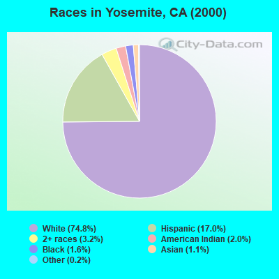
- 1,69474.8%White alone
- 38517.0%Hispanic
- 723.2%Two or more races
- 462.0%American Indian alone
- 371.6%Black alone
- 261.1%Asian alone
- 50.2%Other race alone
 Recent articles from our blog. Our writers, many of them Ph.D. graduates or candidates, create easy-to-read articles on a wide variety of topics.
Current Local Time: PST time zone
Land area: 394.7 square miles.
Population density: 6.0 people per square mile (very low).
| Yosemite CCD: | 0.6% ($550) |
| California: | 0.8% ($1,564) |
Nearest city with pop. 50,000+: Merced, CA  (52.9 miles , pop. 63,893).
Nearest city with pop. 200,000+: Fresno, CA (61.7 miles , pop. 427,652).
Nearest city with pop. 1,000,000+: Los Angeles, CA (257.1 miles , pop. 3,694,820).
Nearest cities:
), ), ), ), )Latitude: 37.66 N, Longitude: 119.63 W
Area code: 209

Yosemite tourist attractions:
| Here: | 5.4% |
| California: | 5.1% |
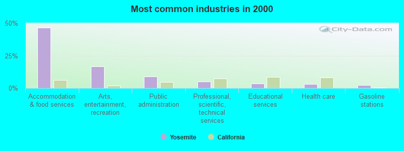
- Accommodation & food services (46.6%)
- Arts, entertainment, recreation (16.8%)
- Public administration (8.9%)
- Professional, scientific, technical services (5.1%)
- Educational services (3.7%)
- Health care (2.9%)
- Gasoline stations (2.4%)
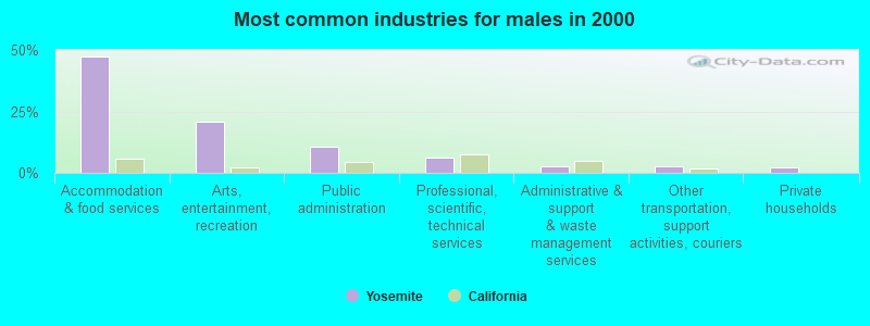
- Accommodation & food services (47.3%)
- Arts, entertainment, recreation (20.7%)
- Public administration (10.6%)
- Professional, scientific, technical services (6.1%)
- Administrative & support & waste management services (2.9%)
- Other transportation, support activities, couriers (2.6%)
- Private households (2.3%)
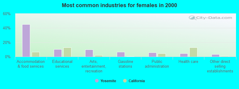
- Accommodation & food services (45.2%)
- Educational services (10.2%)
- Arts, entertainment, recreation (9.8%)
- Gasoline stations (6.6%)
- Public administration (5.8%)
- Health care (4.5%)
- Other direct selling establishments (3.4%)
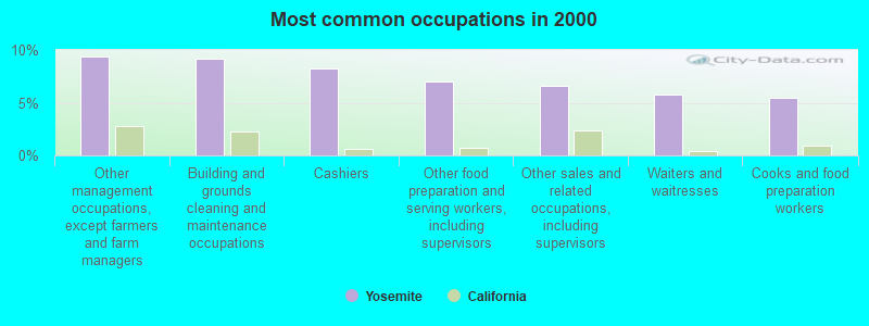
- Other management occupations, except farmers and farm managers (9.3%)
- Building and grounds cleaning and maintenance occupations (9.2%)
- Cashiers (8.3%)
- Other food preparation and serving workers, including supervisors (7.0%)
- Other sales and related occupations, including supervisors (6.6%)
- Waiters and waitresses (5.7%)
- Cooks and food preparation workers (5.5%)
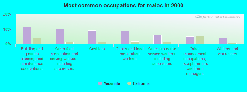
- Building and grounds cleaning and maintenance occupations (11.5%)
- Other food preparation and serving workers, including supervisors (10.0%)
- Cashiers (9.1%)
- Cooks and food preparation workers (8.6%)
- Other protective service workers, including supervisors (6.1%)
- Other management occupations, except farmers and farm managers (4.9%)
- Waiters and waitresses (4.1%)
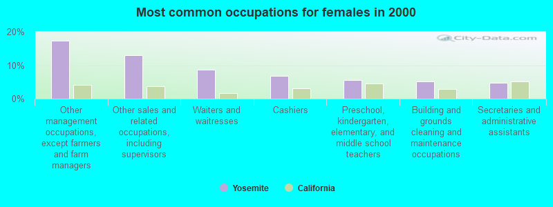
- Other management occupations, except farmers and farm managers (17.3%)
- Other sales and related occupations, including supervisors (13.0%)
- Waiters and waitresses (8.7%)
- Cashiers (6.8%)
- Preschool, kindergarten, elementary, and middle school teachers (5.5%)
- Building and grounds cleaning and maintenance occupations (5.1%)
- Secretaries and administrative assistants (4.7%)
Average climate in Yosemite, California
Based on data reported by over 4,000 weather stations


(lower is better)
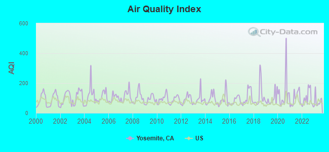
Air Quality Index (AQI) level in 2023 was 78.8. This is about average.
| City: | 78.8 |
| U.S.: | 72.6 |
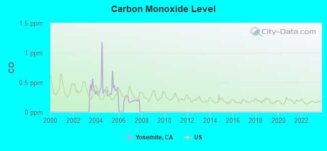
Carbon Monoxide (CO) [ppm] level in 2007 was 0.194. This is better than average. Closest monitor was 5.6 miles away from the city center.
| City: | 0.194 |
| U.S.: | 0.251 |
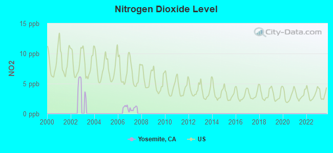
Nitrogen Dioxide (NO2) [ppb] level in 2007 was 0.882. This is significantly better than average. Closest monitor was 5.6 miles away from the city center.
| City: | 0.882 |
| U.S.: | 5.109 |
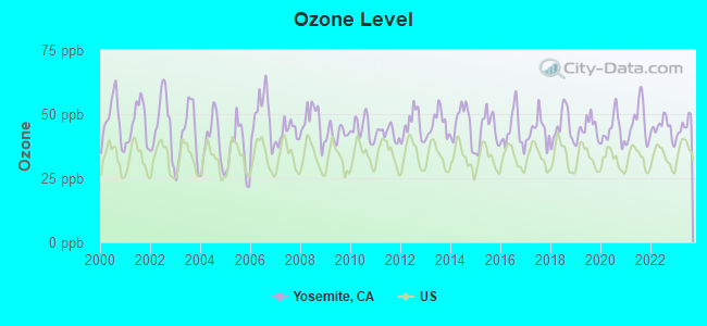
Ozone [ppb] level in 2023 was 45.4. This is worse than average. Closest monitor was 5.5 miles away from the city center.
| City: | 45.4 |
| U.S.: | 33.3 |
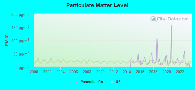
Particulate Matter (PM10) [µg/m3] level in 2022 was 23.9. This is worse than average. Closest monitor was 6.3 miles away from the city center.
| City: | 23.9 |
| U.S.: | 19.2 |
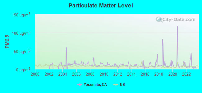
Particulate Matter (PM2.5) [µg/m3] level in 2022 was 12.5. This is significantly worse than average. There were 0 monitors within city limits.
| City: | 12.5 |
| U.S.: | 8.1 |
Earthquake activity:
Yosemite-area historical earthquake activity is significantly above California state average. It is 8459% greater than the overall U.S. average.On 4/18/1906 at 13:12:21, a magnitude 7.9 (7.9 UK, Class: Major, Intensity: VIII - XII) earthquake occurred 185.8 miles away from Yosemite center, causing $524,000,000 total damage
On 7/21/1952 at 11:52:14, a magnitude 7.7 (7.7 UK) earthquake occurred 187.5 miles away from Yosemite center, causing $50,000,000 total damage
On 12/21/1932 at 06:10:09, a magnitude 7.2 (7.2 UK) earthquake occurred 102.3 miles away from the city center
On 10/3/1915 at 06:52:48, a magnitude 7.6 (7.6 UK) earthquake occurred 227.0 miles away from the city center
On 11/4/1927 at 13:51:53, a magnitude 7.5 (7.5 UK) earthquake occurred 205.6 miles away from Yosemite center
On 10/18/1989 at 00:04:15, a magnitude 7.1 (6.5 MB, 7.1 MS, 6.9 MW, 7.0 ML) earthquake occurred 123.9 miles away from Yosemite center, causing 62 deaths (62 shaking deaths) and 3757 injuries, causing $1,305,032,704 total damage
Magnitude types: body-wave magnitude (MB), local magnitude (ML), surface-wave magnitude (MS), moment magnitude (MW)
Natural disasters:
The number of natural disasters in Mariposa County (13) is near the US average (15).Major Disasters (Presidential) Declared: 4
Emergencies Declared: 3
Causes of natural disasters: Floods: 7, Winter Storms: 4, Fires: 3, Landslides: 3, Mudslides: 3, Storms: 3, Drought: 1, Hurricane: 1, Tornado: 1, Other: 1 (Note: some incidents may be assigned to more than one category).
Colleges/universities with over 2000 students nearest to Yosemite:
- University of California-Merced (about 49 miles; Merced, CA; Full-time enrollment: 5,981)
- Merced College (about 52 miles; Merced, CA; FT enrollment: 6,973)
- University of Phoenix-Central Valley Campus (about 57 miles; Fresno, CA; FT enrollment: 2,109)
- Institute of Technology Inc (about 58 miles; Clovis, CA; FT enrollment: 2,483)
- Heald College-Fresno (about 59 miles; Fresno, CA; FT enrollment: 2,199)
- California State University-Fresno (about 60 miles; Fresno, CA; FT enrollment: 18,993)
- Fresno City College (about 63 miles; Fresno, CA; FT enrollment: 12,994)
Public elementary/middle school in Yosemite:
- YOSEMITE NATIONAL PARK VALLEY ELEMENTARY (Students: 19, Location: 9009 LOST ARROW LOOP, Grades: KG-6)
Points of interest:
Notable locations in Yosemite: Summerdale Campground (A), Yosemite Creek Campground (B), Merced Lake High Sierra Camp (C), Grizzly Giant (D), South Entrance (E), Valley View (F), Tunnel Tree (G), Chinquapin (H), May Lake High Sierra Camp (I), Porcupine Flat Campground (J), Tenaya Lake Campground (K), Cathedral Beach Picnic Area (L), Clark Point (M), El Capitan Picnic Area (N), Group Camp (O), Housekeeping Camp (P), Lower Pines Campground (Q), Lower River Campground (R), North Pines Campground (S), Sentinel Beach Picnic Area (T). Display/hide their locations on the map
Lakes: Obelisk Lake (A), Gallison Lake (B), Hart Lakes (C), Emerald Pool (D), Reymann Lake (E), Lost Lake (F), Hidden Lake (G), El Capitan Meadow (H). Display/hide their locations on the map
Streams, rivers, and creeks: Tamarack Creek (A), Strawberry Creek (B), Ribbon Creek (C), Lewis Creek (D), Florence Creek (E), Fletcher Creek (F), Meadow Brook (G), Indian Creek (H), Illilouette Creek (I). Display/hide their locations on the map
Parks in Yosemite include: Yosemite National Park (1), Camp Curry Historic District (2), El Portal Park (3). Display/hide their locations on the map
| This place: | 2.2 people |
| California: | 2.9 people |
| This place: | 27.3% |
| Whole state: | 69.4% |
| This place: | 4.4% |
| Whole state: | 5.9% |
Likely homosexual households (counted as self-reported same-sex unmarried-partner households)
- Lesbian couples: 0.2% of all households
- Gay men: 0.6% of all households
| This place: | 20.9% |
| Whole state: | 14.2% |
| This place: | 10.1% |
| Whole state: | 6.3% |
25 people in unknown juvenile institutions in 2000
For population 15 years and over in Yosemite:
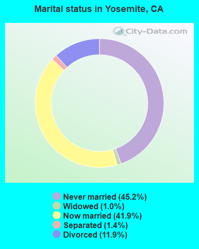
- Never married: 45.2%
- Now married: 41.9%
- Separated: 1.4%
- Widowed: 1.0%
- Divorced: 11.9%
For population 25 years and over in Yosemite:
- High school or higher: 86.1%
- Bachelor's degree or higher: 29.3%
- Graduate or professional degree: 6.6%
- Unemployed: 27.8%
- Mean travel time to work (commute): 14.7 minutes
| Here: | 13.2 |
| California average: | 16.1 |
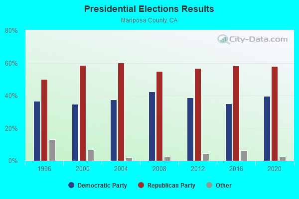
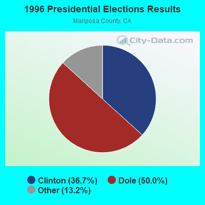
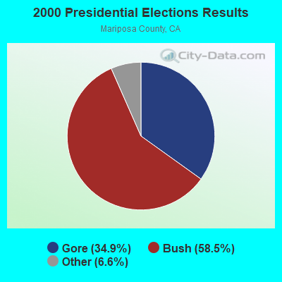
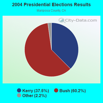
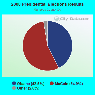
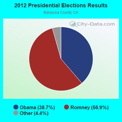
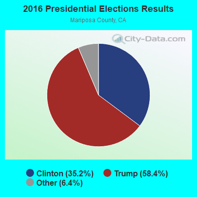
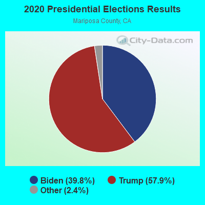
Graphs represent county-level data. Detailed 2008 Election Results
Religion statistics for Yosemite, CA (based on Mariposa County data)
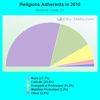
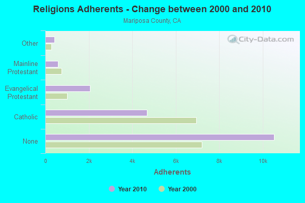
| Religion | Adherents | Congregations |
|---|---|---|
| Catholic | 4,671 | 3 |
| Evangelical Protestant | 2,048 | 20 |
| Mainline Protestant | 578 | 3 |
| Other | 431 | 5 |
| None | 10,523 | - |
Food Environment Statistics:
| Here: | 6.67 / 10,000 pop. |
| California: | 2.14 / 10,000 pop. |
| Mariposa County: | 2.22 / 10,000 pop. |
| State: | 0.62 / 10,000 pop. |
| Mariposa County: | 3.33 / 10,000 pop. |
| California: | 1.49 / 10,000 pop. |
| Mariposa County: | 5.56 / 10,000 pop. |
| California: | 7.42 / 10,000 pop. |
| Here: | 7.9% |
| California: | 7.3% |
| This county: | 23.2% |
| State: | 21.3% |
| Mariposa County: | 14.2% |
| California: | 17.9% |
Strongest AM radio stations in Yosemite:
- KMJ (580 AM; 50 kW; FRESNO, CA; Owner: INFINITY RADIO OPERATIONS INC.)
- KCBC (770 AM; 50 kW; RIVERBANK, CA; Owner: KIERTRON, INC.)
- KWRU (940 AM; 50 kW; FRESNO, CA)
- KTNS (1060 AM; 5 kW; OAKHURST, CA; Owner: CALIFORNIA SIERRA CORPORATION)
- KHTK (1140 AM; 50 kW; SACRAMENTO, CA; Owner: INFINITY RADIO SUBSIDIARY OPERATIONS INC.)
- KOOR (790 AM; 10 kW; CLOVIS, CA; Owner: INFINITY RADIO OPERATIONS INC.)
- KNBR (680 AM; 50 kW; SAN FRANCISCO, CA; Owner: KNBR LICO, INC.)
- KGO (810 AM; 50 kW; SAN FRANCISCO, CA; Owner: KGO-AM RADIO, INC.)
- KSTE (650 AM; 25 kW; RANCHO CORDOVA, CA; Owner: AMFM RADIO LICENSES, L.L.C.)
- KKOH (780 AM; 50 kW; RENO, NV; Owner: CITADEL BROADCASTING COMPANY)
- KLOK (1170 AM; 50 kW; SAN JOSE, CA; Owner: ENTRAVISION HOLDINGS, LLC)
- KTRB (860 AM; 50 kW; MODESTO, CA; Owner: PAPPAS RADIO OF CALIFORNIA, A CALIFORNIA LIMITED PARTNERSHIP)
- KTCT (1050 AM; 50 kW; SAN MATEO, CA; Owner: SUSQUEHANNA RADIO CORP.)
Strongest FM radio stations in Yosemite:
- KAAT (103.1 FM; OAKHURST, CA; Owner: CALIFORNIA SIERRA CORPORATION)
- KDJK (103.9 FM; MARIPOSA, CA; Owner: CITADEL BROADCASTING COMPANY)
- KEFR (89.9 FM; LE GRAND, CA; Owner: FAMILY STATIONS, INC.)
- KCIV (99.9 FM; MOUNT BULLION, CA; Owner: BOTT COMMUNICATIONS, INC.)
- KUBB (96.3 FM; MARIPOSA, CA; Owner: BUCKLEY BROADCASTING CORP. OF MONTEREY INC)
- KMPO (88.7 FM; MODESTO, CA; Owner: RADIO BILINGUE, INC.)
- K214CT (90.7 FM; MARIPOSA, CA; Owner: CALVARY CHAPEL OF TWIN FALLS, INC.)
- KMMT (106.5 FM; MAMMOTH LAKES, CA; Owner: MAMMOTH MOUNTAIN FM ASSOCIATES,INC.)
- KAMB (101.5 FM; MERCED, CA; Owner: CENTRAL VALLEY BROADCASTING CO. INC.)
- KZOL (107.9 FM; NORTH FORK, CA; Owner: HBC LICENSE CORPORATION)
- KFNO (90.3 FM; FRESNO, CA; Owner: FAMILY STATIONS, INC.)
- KLBN (105.1 FM; AUBERRY, CA; Owner: LOTUS COMMUNICATIONS CORP.)
- KOQO-FM (101.9 FM; FRESNO, CA; Owner: INFINITY RADIO OPERATIONS INC.)
- KRNC (105.9 FM; FRESNO, CA; Owner: INFINITY RADIO OPERATIONS INC.)
- KSKS (93.7 FM; FRESNO, CA; Owner: INFINITY RADIO OPERATIONS INC.)
- K276BW (103.1 FM; NORTH FORK BASS LAKE, CA; Owner: CALIFORNIA SIERRA CORPORATION)
- KFCF (88.1 FM; FRESNO, CA; Owner: FRESNO FREE COLLEGE FOUNDATION)
- KVPR (89.3 FM; FRESNO, CA; Owner: WHITE ASH BROADCASTING, INC.)
- KMMM (107.1 FM; MADERA, CA; Owner: ILLINOIS LOTUS CORP)
- KSVL (92.3 FM; SMITH, NV; Owner: DONEGAL ENTERPRISES)
FCC Registered Cell Phone Towers:
6- 9358 Glacier Point Road (Lat: 37.727139 Lon: -119.581833), Call Sign: KNKN346
Assigned Frequencies: 880.020 MHz, 891.510 MHz, 835.020 MHz, 846.510 MHzGrant Date: 09/01/2020, Expiration Date: 10/01/2030Registrant: Verizon Wireless, 5055 North Point Pkwy, Np2ne Network Engineering, Alpharetta, GA 30022, Phone: (770) 797-1070, Fax: (678) 259-1319, Email:
- Sentinel Dome 9358 Glacial Point Road (Lat: 37.727139 Lon: -119.581833), Call Sign: KNKN240
Assigned Frequencies: 880.020 MHz, 891.510 MHz, 835.020 MHz, 846.510 MHzGrant Date: 09/01/2020, Expiration Date: 10/01/2030, Certifier: Gregory M RomanoRegistrant: Verizon Wireless, 5055 North Point Pkwy, Np2ne Network Engineering, Alpharetta, GA 30022, Phone: (770) 797-1070, Email:
- Tuolumne Meadows 9043 Tuolumne Lodge Road (Lat: 37.877694 Lon: -119.344333), Call Sign: KNKN240
Assigned Frequencies: 880.020 MHz, 891.510 MHz, 835.020 MHz, 846.510 MHzGrant Date: 09/01/2020, Expiration Date: 10/01/2030, Certifier: Gregory M RomanoRegistrant: Verizon Wireless, 5055 North Point Pkwy, Np2ne Network Engineering, Alpharetta, GA 30022, Phone: (770) 797-1070, Email:
- Wawona Point Road (Lat: 37.518556 Lon: -119.600694), Call Sign: KNKN240
Assigned Frequencies: 880.020 MHz, 891.510 MHz, 835.020 MHz, 846.510 MHzGrant Date: 09/01/2020, Expiration Date: 10/01/2030, Certifier: Gregory M RomanoRegistrant: Verizon Wireless, 5055 North Point Pkwy, Np2ne Network Engineering, Alpharetta, GA 30022, Phone: (770) 797-1070, Email:
- Yosemite 9013 Tenya Way (Lat: 37.750472 Lon: -119.587944), Call Sign: KNKN240
Assigned Frequencies: 880.020 MHz, 891.510 MHz, 835.020 MHz, 846.510 MHzGrant Date: 09/01/2020, Expiration Date: 10/01/2030, Certifier: Gregory M RomanoRegistrant: Verizon Wireless, 5055 North Point Pkwy, Np2ne Network Engineering, Alpharetta, GA 30022, Phone: (770) 797-1070, Email:
- Crane Flat 8176 Big Oak Flat Road (Lat: 37.759639 Lon: -119.820444), Call Sign: KNKN240
Assigned Frequencies: 880.020 MHz, 891.510 MHz, 835.020 MHz, 846.510 MHzGrant Date: 09/01/2020, Expiration Date: 10/01/2030, Certifier: Gregory M RomanoRegistrant: Verizon Wireless, 5055 North Point Pkwy, Np2ne Network Engineering, Alpharetta, GA 30022, Phone: (770) 797-1070, Email:
FCC Registered Broadcast Land Mobile Towers:
1- Yosemite Park Hdqtrs 120 Ft S Of Gov Stables (Lat: 37.748528 Lon: -119.591278), Type: Building, Structure height: 2 m, Overall height: 3 m, Call Sign: KVJ34, Licensee ID: L00008262,
Assigned Frequencies: 170.325 MHz, Grant Date: 10/16/1997, Expiration Date: 10/16/2002, Cancellation Date: 08/22/2002, Certifier: Bobby Mooneyham, Registrant: Merced Irrigation District, Merced, CA 95344, Phone: (209) 378-2421, Fax: (209) 378-2303
FCC Registered Microwave Towers:
7- Lat: 36.999917 Lon: -118.000917, Overall height: 6.1 m, Call Sign: WPNA381,
Assigned Frequencies: 39000.0 MHz, 39050.0 MHz, Grant Date: 08/13/1997, Expiration Date: 02/01/2001, Cancellation Date: 05/06/2001, Phone: (608) 756-4523
- Lat: 36.999917 Lon: -118.000917, Overall height: 6.1 m, Call Sign: WPNE977,
Assigned Frequencies: 38900.0 MHz, 38950.0 MHz, Grant Date: 06/04/1997, Expiration Date: 02/01/2001, Cancellation Date: 05/06/2001, Phone: (602) 994-0919
- Lat: 37.249917 Lon: -118.000917, Structure height: 6.1 m, Call Sign: WPNF256,
Assigned Frequencies: 39300.0 MHz, 39350.0 MHz, Grant Date: 08/13/1997, Expiration Date: 08/13/2007, Cancellation Date: 02/28/2007, Registrant: At&t Corp., 2315 Salem Road, First Floor, H9, Conyers, GA 30013, Phone: (770) 602-2065, Email:
- HENNESS RDG TOWER, 400' Ne Of Lookout Twr (Lat: 37.639417 Lon: -119.720611), Type: Ltower, Structure height: 38.1 m, Overall height: 41.8 m, Call Sign: WQWS402,
Assigned Frequencies: 5945.20 MHz, 6063.80 MHz, 6725.00 MHz, 6785.00 MHz, 6004.50 MHz, 6093.45 MHz, 6755.00 MHz, 6063.80 MHz, 6123.10 MHz, 5974.85 MHz, 6034.15 MHz, 6093.45 MHz, Grant Date: 11/04/2015, Expiration Date: 02/01/2025, Certifier: Jonathan Kaufman, Registrant: At&t Services, Inc., 208 S. Akard Street, 20f, Dallas, TX 75202, Phone: (855) 699-7073, Email:
- SENTINEL DOME, 8957 Glacier Pt Rd (Lat: 37.727028 Lon: -119.581611), Type: Mtower, Structure height: 13.4 m, Overall height: 16.5 m, Call Sign: WQYB314,
Assigned Frequencies: 6093.45 MHz, 6063.80 MHz, Grant Date: 08/05/2016, Expiration Date: 08/05/2026, Certifier: Gregory M Romano, Registrant: Verizon, 1300 I St Nw - Suite 500 East, Washington, DC 20005, Phone: (202) 515-2453, Email:
- YOSEMITE VLG, Located In Yosemite Village (Lat: 37.749750 Lon: -119.588500), Type: Mtower, Structure height: 6.4 m, Overall height: 7.6 m, Call Sign: WBO43,
Assigned Frequencies: 17980.0 MHz, 18060.0 MHz, 10735.0 MHz, 10935.0 MHz, 10775.0 MHz, 10975.0 MHz, 10815.0 MHz, 11015.0 MHz, 10855.0 MHz, 11055.0 MHz, 10895.0 MHz, 11095.0 MHz, Grant Date: 07/14/2020, Expiration Date: 08/01/2030, Registrant: At&t Services, Inc., 208 S. Akard Street, 20f, Dallas, TX 75202, Phone: (855) 699-7073, Email:
- HENNESS RDG, 400' Ne Lookout Twr (Lat: 37.639444 Lon: -119.720528), Type: Mtower, Structure height: 9.8 m, Overall height: 11.6 m, Call Sign: WLU999,
Assigned Frequencies: 11135.0 MHz, 11175.0 MHz, 5974.85 MHz, 6152.75 MHz, Grant Date: 07/14/2020, Expiration Date: 08/01/2030, Registrant: At&t Services, Inc., 208 S. Akard Street, 20f, Dallas, TX 75202, Phone: (855) 699-7073, Email:
FCC Registered Amateur Radio Licenses:
8 (See the full list of FCC Registered Amateur Radio Licenses in Yosemite)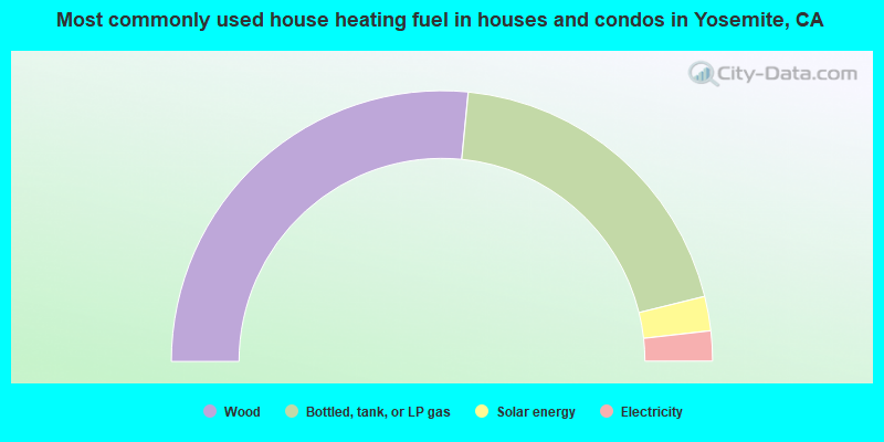
- 53.1%Wood
- 39.2%Bottled, tank, or LP gas
- 4.1%Solar energy
- 3.6%Electricity
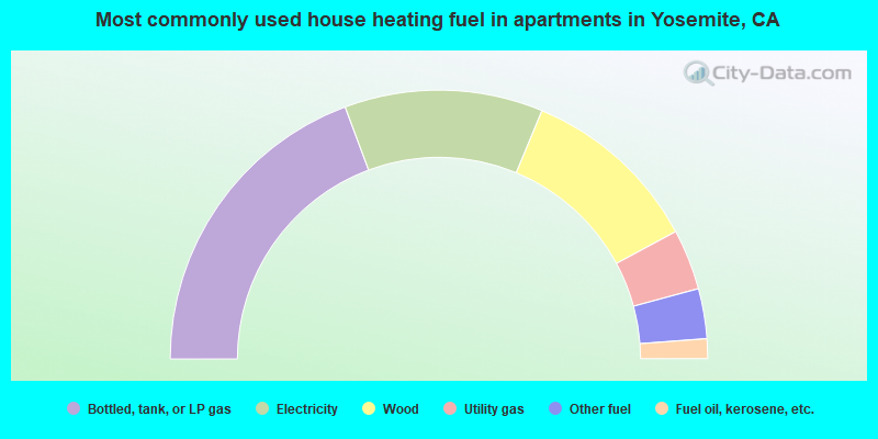
- 38.7%Bottled, tank, or LP gas
- 23.9%Electricity
- 21.8%Wood
- 7.3%Utility gas
- 6.0%Other fuel
- 2.4%Fuel oil, kerosene, etc.
Yosemite compared to California state average:
- Median house value significantly below state average.
- Unemployed percentage above state average.
- Black race population percentage significantly below state average.
- Hispanic race population percentage below state average.
- Foreign-born population percentage significantly below state average.
- Renting percentage significantly below state average.
- Length of stay since moving in significantly above state average.
- Number of rooms per house significantly below state average.
- House age significantly below state average.
- Institutionalized population percentage significantly above state average.
Yosemite on our top lists:
- #1 on the list of "Top 101 cities with the largest percentage of people in other workers' dormitories (population 1,000+)"
- #17 on the list of "Top 101 cities with the lowest percentage of family households, population 1,000+"
- #30 on the list of "Top 101 cities with the largest percentage of people in unknown juvenile institutions (population 1,000+)"
- #11 (95389) on the list of "Top 101 zip codes with the lowest 2012 average net capital gain/loss (pop 1,000+)"
- #62 (95389) on the list of "Top 101 zip codes with the smallest percentage of taxpayers reporting profit/loss from business in 2012 (pop 1,000+)"
- #78 (95389) on the list of "Top 101 zip codes with the largest percentage of returns reporting salary or wage in 2012 (pop 1,000+)"
- #95 (95389) on the list of "Top 101 zip codes with the lowest charity contributions deductions as a percentage of AGI in 2012 (pop 1,000+)"
- #1 on the list of "Top 101 counties with the highest Ozone (1-hour) air pollution readings in 2012 (ppm)"
- #58 on the list of "Top 101 counties with highest percentage of residents voting for 3rd party candidates in the 2012 Presidential Election"

|
Total of 3 patent applications in 2008-2024.