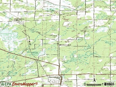
Worcester, Wisconsin
Submit your own pictures of this town and show them to the world
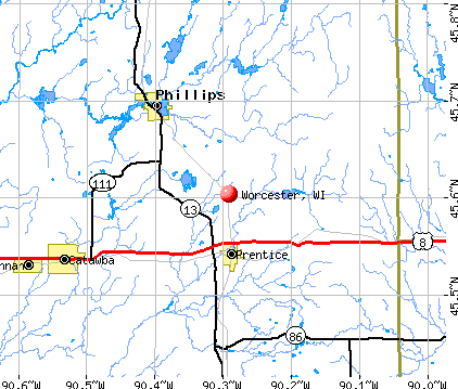
- OSM Map
- General Map
- Google Map
- MSN Map
Population change since 2000: -9.1%
 |
| Males: 804 | |
| Females: 751 |
| Median resident age: | 49.3 years |
| Wisconsin median age: | 42.6 years |
Zip codes: 54555.
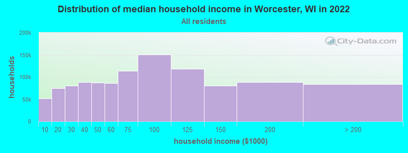
| Worcester: | $60,128 |
| WI: | $70,996 |
Estimated per capita income in 2022: $33,789 (it was $17,982 in 2000)
Worcester town income, earnings, and wages data
Estimated median house or condo value in 2022: $173,473 (it was $84,400 in 2000)
| Worcester: | $173,473 |
| WI: | $252,800 |
Mean prices in 2022: all housing units: $221,240; detached houses: $231,356; townhouses or other attached units: $328,766; in 2-unit structures: $155,202; in 3-to-4-unit structures: $167,011; mobile homes: $83,835
Detailed information about poverty and poor residents in Worcester, WI
Compare current foreclosures near Worcester, WI:
| Photo | Address | Area | Beds / Baths | Price | Details |
|---|---|---|---|---|---|

|
#1
County Rd H
Phillips, WI 54555
|
- sq. feet
|
1 baths 3 beds |
show details | |

|
#2
County Road H
Phillips, WI 54555
|
- sq. feet
|
- baths - beds |
show details | |

|
#3
State Highway 13
Fifield, WI 54524
|
- sq. feet
|
- baths - beds |
show details | |

|
#4
S Soo Lake Road
Phillips, WI 54555
|
- sq. feet
|
- baths - beds |
show details | |

|
#5
7th Ave S
Park Falls, WI 54552
|
- sq. feet
|
- baths - beds |
show details | |

|
#6
Sherry Ave
Park Falls, WI 54552
|
- sq. feet
|
- baths - beds |
show details | |

|
Check over 1 million property listings on Foreclosure.com!
|
browse all offers | |||

- 1,53398.6%White alone
- 100.6%Two or more races
- 50.3%American Indian alone
- 40.3%Hispanic
- 20.1%Native Hawaiian and Other
Pacific Islander alone - 10.06%Black alone
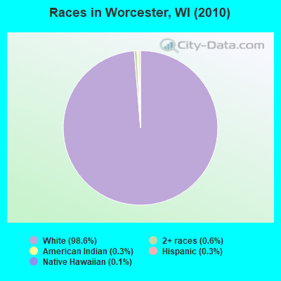
Races in Worcester detailed stats: ancestries, foreign born residents, place of birth
 Recent articles from our blog. Our writers, many of them Ph.D. graduates or candidates, create easy-to-read articles on a wide variety of topics.

Latest news from Worcester, WI collected exclusively by city-data.com from local newspapers, TV, and radio stations
Ancestries: German (41.6%), Czech (16.0%), Polish (10.5%), Irish (9.6%), Swedish (7.4%), Norwegian (5.5%).
Current Local Time: CST time zone
Elevation: 1615 feet
Land area: 117.3 square miles.
Population density: 13 people per square mile (very low).
11 residents are foreign born
| This town: | 0.6% |
| Wisconsin: | 3.6% |
| Worcester town: | 1.5% ($1,263) |
| Wisconsin: | 2.0% ($2,245) |
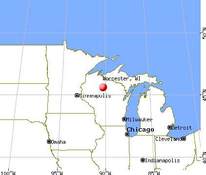
Nearest city with pop. 50,000+: Eau Claire, WI  (84.9 miles , pop. 61,704).
Nearest city with pop. 200,000+: St. Paul, MN (145.5 miles , pop. 287,151).
Nearest city with pop. 1,000,000+: Chicago, IL (300.0 miles , pop. 2,896,016).
Nearest cities:
), ), ), ), Latitude: 45.73 N, Longitude: 90.33 W
Area code commonly used in this area: 715

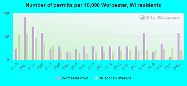
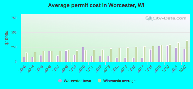
Single-family new house construction building permits:
- 2022: 10 buildings, average cost: $222,600
- 2021: 1 building, cost: $244,800
- 2020: 6 buildings, average cost: $278,400
- 2019: 3 buildings, average cost: $270,700
- 2018: 10 buildings, average cost: $214,500
- 2017: 5 buildings, average cost: $70,000
- 2016: 5 buildings, average cost: $70,000
- 2015: 5 buildings, average cost: $70,000
- 2014: 5 buildings, average cost: $70,000
- 2013: 5 buildings, average cost: $93,800
- 2012: 5 buildings, average cost: $93,800
- 2011: 5 buildings, average cost: $93,800
- 2010: 4 buildings, average cost: $251,300
- 2009: 3 buildings, average cost: $120,000
- 2008: 5 buildings, average cost: $190,800
- 2007: 4 buildings, average cost: $103,800
- 2006: 10 buildings, average cost: $183,600
- 2005: 12 buildings, average cost: $110,400
- 2004: 16 buildings, average cost: $81,300
- 2003: 4 buildings, average cost: $87,500
| Here: | 3.5% |
| Wisconsin: | 2.7% |
- Machinery (10.2%)
- Plastics & rubber products (9.5%)
- Educational services (8.2%)
- Wood products (7.2%)
- Health care (5.9%)
- Construction (5.4%)
- Agriculture, forestry, fishing & hunting (4.6%)
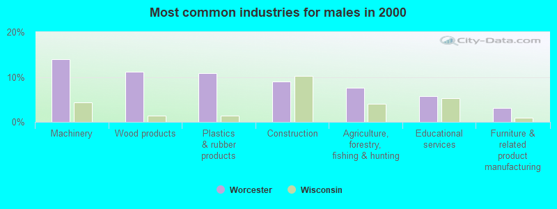
- Machinery (14.0%)
- Wood products (11.1%)
- Plastics & rubber products (10.9%)
- Construction (9.1%)
- Agriculture, forestry, fishing & hunting (7.6%)
- Educational services (5.8%)
- Furniture & related product manufacturing (3.1%)
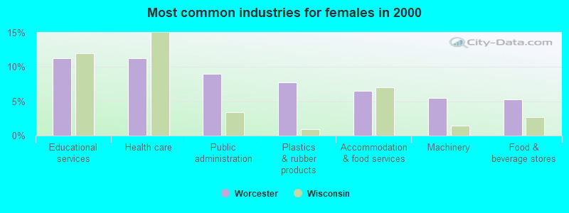
- Educational services (11.3%)
- Health care (11.3%)
- Public administration (9.0%)
- Plastics & rubber products (7.8%)
- Accommodation & food services (6.5%)
- Machinery (5.5%)
- Food & beverage stores (5.3%)
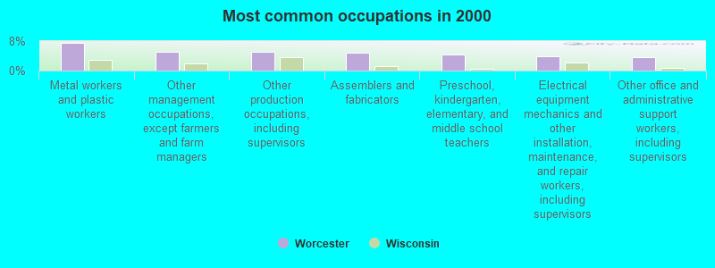
- Metal workers and plastic workers (7.6%)
- Other management occupations, except farmers and farm managers (5.1%)
- Other production occupations, including supervisors (5.0%)
- Assemblers and fabricators (4.7%)
- Preschool, kindergarten, elementary, and middle school teachers (4.3%)
- Electrical equipment mechanics and other installation, maintenance, and repair workers, including supervisors (4.0%)
- Other office and administrative support workers, including supervisors (3.7%)
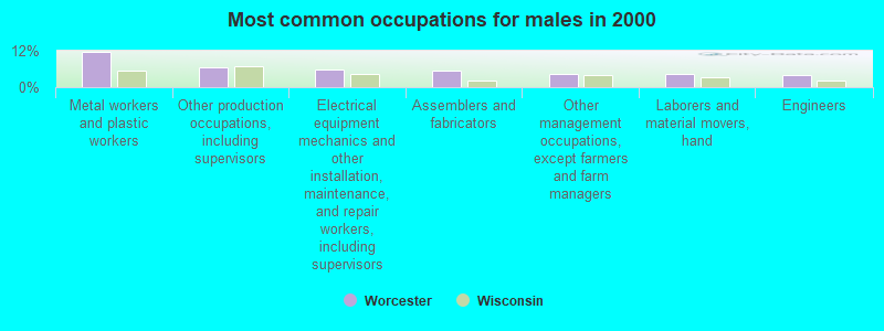
- Metal workers and plastic workers (11.7%)
- Other production occupations, including supervisors (6.6%)
- Electrical equipment mechanics and other installation, maintenance, and repair workers, including supervisors (6.0%)
- Assemblers and fabricators (5.3%)
- Other management occupations, except farmers and farm managers (4.5%)
- Laborers and material movers, hand (4.5%)
- Engineers (3.9%)
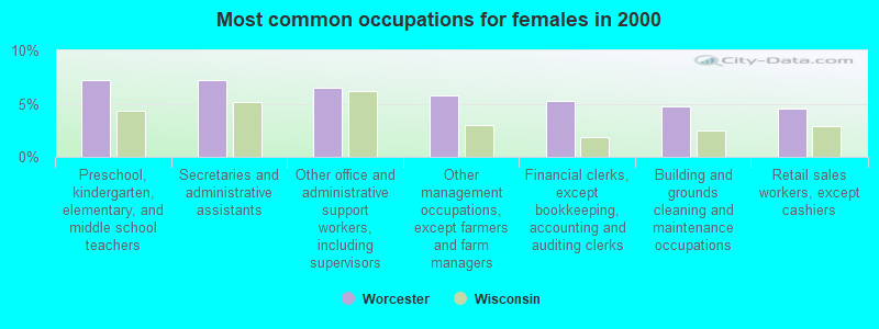
- Preschool, kindergarten, elementary, and middle school teachers (7.3%)
- Secretaries and administrative assistants (7.3%)
- Other office and administrative support workers, including supervisors (6.5%)
- Other management occupations, except farmers and farm managers (5.8%)
- Financial clerks, except bookkeeping, accounting and auditing clerks (5.3%)
- Building and grounds cleaning and maintenance occupations (4.8%)
- Retail sales workers, except cashiers (4.5%)
Average climate in Worcester, Wisconsin
Based on data reported by over 4,000 weather stations


Tornado activity:
Worcester-area historical tornado activity is below Wisconsin state average. It is 37% smaller than the overall U.S. average.
On 5/10/1953, a category F4 (max. wind speeds 207-260 mph) tornado 16.6 miles away from the Worcester town center killed 2 people and injured 24 people.
On 6/8/1985, a category F3 (max. wind speeds 158-206 mph) tornado 15.2 miles away from the town center killed 2 people and injured 42 people and caused between $5,000,000 and $50,000,000 in damages.
Earthquake activity:
Worcester-area historical earthquake activity is significantly above Wisconsin state average. It is 75% smaller than the overall U.S. average.On 7/9/1975 at 14:54:15, a magnitude 4.6 (4.6 MB, Class: Light, Intensity: IV - V) earthquake occurred 275.7 miles away from Worcester center
On 6/28/2004 at 06:10:52, a magnitude 4.2 (4.2 MW, Depth: 6.2 mi) earthquake occurred 304.1 miles away from the city center
On 6/5/1993 at 01:24:53, a magnitude 4.1 (4.1 LG, Depth: 6.2 mi) earthquake occurred 287.8 miles away from Worcester center
On 2/7/2020 at 18:30:28, a magnitude 3.3 (3.3 ML, Class: Light, Intensity: II - III) earthquake occurred 165.8 miles away from Worcester center
On 4/8/2020 at 17:14:33, a magnitude 3.3 (3.3 ML) earthquake occurred 167.8 miles away from the city center
On 1/9/2020 at 18:16:48, a magnitude 3.3 (3.3 MB) earthquake occurred 167.9 miles away from the city center
Magnitude types: regional Lg-wave magnitude (LG), body-wave magnitude (MB), local magnitude (ML), moment magnitude (MW)
Natural disasters:
The number of natural disasters in Price County (7) is smaller than the US average (15).Major Disasters (Presidential) Declared: 4
Emergencies Declared: 3
Causes of natural disasters: Floods: 3, Storms: 3, Tornadoes: 2, Winds: 2, Drought: 1, Hurricane: 1, Other: 1 (Note: some incidents may be assigned to more than one category).
Hospitals and medical centers near Worcester:
- FLAMBEAU HM HLTH AND HSPC (Home Health Center, about 5 miles away; PHILLIPS, WI)
- ASPIRUS PLEASANT VIEW (Nursing Home, about 5 miles away; PHILLIPS, WI)
- FLAMBEAU HOSPITAL INC (Hospital, about 15 miles away; PARK FALLS, WI)
- PARK MNR LTD (Nursing Home, about 15 miles away; PARK FALLS, WI)
- SUPPORTIVE HOME SVCS (Home Health Center, about 16 miles away; PARK FALLS, WI)
Colleges/universities with over 2000 students nearest to Worcester:
- Northcentral Technical College (about 62 miles; Wausau, WI; Full-time enrollment: 3,356)
- Wisconsin Indianhead Technical College (about 77 miles; Shell Lake, WI; FT enrollment: 2,414)
- University of Wisconsin-Eau Claire (about 86 miles; Eau Claire, WI; FT enrollment: 10,143)
- Chippewa Valley Technical College (about 87 miles; Eau Claire, WI; FT enrollment: 4,038)
- University of Wisconsin-Stevens Point (about 92 miles; Stevens Point, WI; FT enrollment: 9,089)
- Mid-State Technical College (about 97 miles; Wisconsin Rapids, WI; FT enrollment: 2,128)
- University of Wisconsin-Stout (about 98 miles; Menomonie, WI; FT enrollment: 8,120)
Points of interest:
Notable locations in Worcester: Upper Squaw Creek Waterfowl Area (A), Lower Squaw Creek Waterfowl Area (B). Display/hide their locations on the map
Church in Worcester: Holy Cross King of Martyrs Priory (A). Display/hide its location on the map
Lakes and reservoirs: Murphy Lake (A), Bass Lake (B), Wilson Flowage (C), Big Dardis Lake (D), Deer Lake (E), Donavan Lake (F), Little Dardis Lake (G), Lost Lake (H). Display/hide their locations on the map
Rivers and creeks: Little Elk River (A), Popple Creek (B), Horton Creek (C), Hoffman Creek (D), Chase Creek (E), Spring Creek (F), Cramer Creek (G). Display/hide their locations on the map
Park in Worcester: Solberg Lake County Park (1). Display/hide its location on the map
| This town: | 2.2 people |
| Wisconsin: | 2.4 people |
| This town: | 69.5% |
| Whole state: | 64.4% |
| This town: | 3.7% |
| Whole state: | 7.3% |
Likely homosexual households (counted as self-reported same-sex unmarried-partner households)
- Lesbian couples: 0.0% of all households
- Gay men: 0.4% of all households
| This town: | 4.3% |
| Whole state: | 8.7% |
| This town: | 1.0% |
| Whole state: | 3.7% |
For population 15 years and over in Worcester:
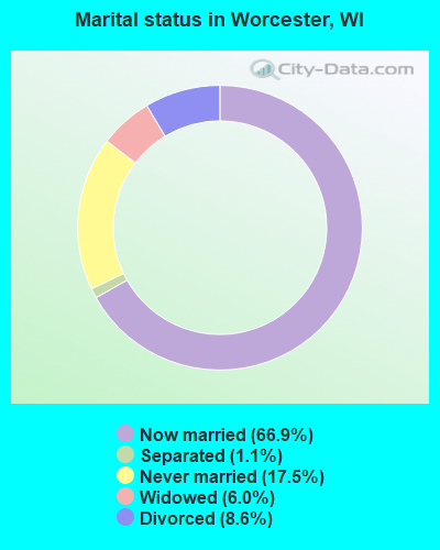
- Never married: 17.5%
- Now married: 66.9%
- Separated: 1.1%
- Widowed: 6.0%
- Divorced: 8.6%
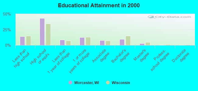
For population 25 years and over in Worcester:
- High school or higher: 85.9%
- Bachelor's degree or higher: 13.6%
- Graduate or professional degree: 4.1%
- Unemployed: 4.9%
- Mean travel time to work (commute): 16.5 minutes
| Here: | 9.8 |
| Wisconsin average: | 11.0 |
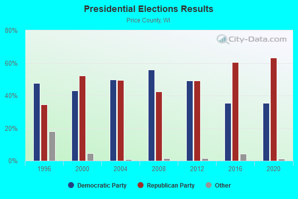
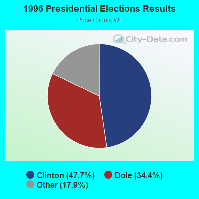
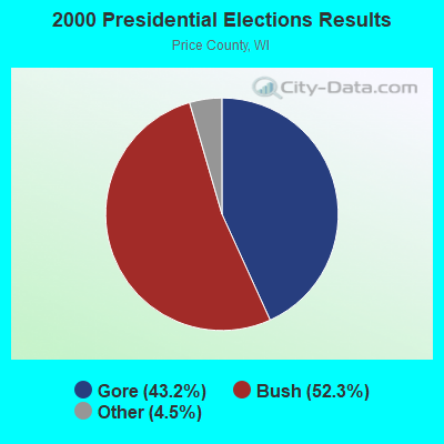
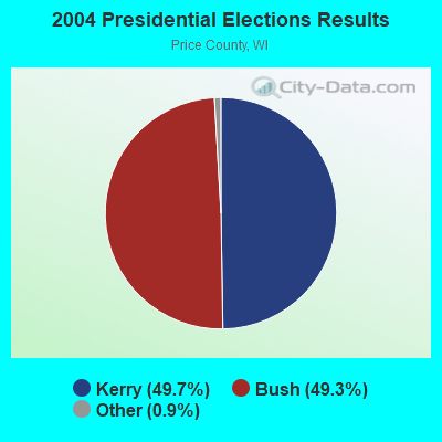
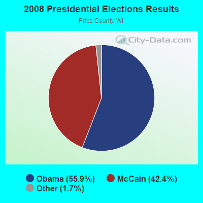
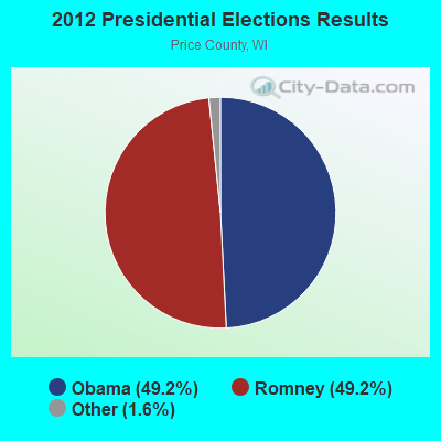
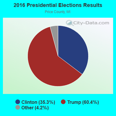
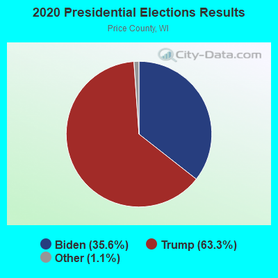
Graphs represent county-level data. Detailed 2008 Election Results
Religion statistics for Worcester, WI (based on Price County data)
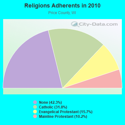
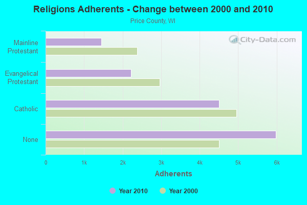
| Religion | Adherents | Congregations |
|---|---|---|
| Catholic | 4,502 | 5 |
| Evangelical Protestant | 2,224 | 20 |
| Mainline Protestant | 1,445 | 9 |
| Other | 3 | 1 |
| Orthodox | - | - |
| None | 5,985 | - |
Food Environment Statistics:
| This county: | 4.16 / 10,000 pop. |
| Wisconsin: | 1.86 / 10,000 pop. |
| Price County: | 1.39 / 10,000 pop. |
| State: | 0.38 / 10,000 pop. |
| Here: | 6.93 / 10,000 pop. |
| Wisconsin: | 4.12 / 10,000 pop. |
| Price County: | 11.79 / 10,000 pop. |
| Wisconsin: | 8.64 / 10,000 pop. |
| This county: | 9.2% |
| State: | 7.6% |
| Price County: | 28.3% |
| Wisconsin: | 27.5% |
| This county: | 13.1% |
| Wisconsin: | 13.0% |
Strongest AM radio stations in Worcester:
- WEBC (560 AM; 50 kW; DULUTH, MN)
- WSAU (550 AM; 20 kW; WAUSAU, WI; Owner: WRIG, INC.)
- WSPT (1010 AM; 50 kW; STEVENS POINT, WI)
- WNBI (980 AM; 1 kW; PARK FALLS, WI)
- WLKD (1570 AM; 5 kW; MINOCQUA, WI; Owner: RAVEN BROADCASTING CORPORATION)
- WJMS (590 AM; 5 kW; IRONWOOD, MI; Owner: ROBERTS BROADCASTING, INC.)
- WCCO (830 AM; 50 kW; MINNEAPOLIS, MN; Owner: INFINITY MEDIA CORPORATION)
- WCTS (1030 AM; 50 kW; MAPLEWOOD, MN; Owner: CNTL. BAPT. THEO/AL SEMI MINNEAPOLIS)
- WNAM (1280 AM; 50 kW; NEENAH-MENASHA, WI; Owner: CUMULUS LICENSING CORP.)
- KSTP (1500 AM; 50 kW; ST. PAUL, MN; Owner: KSTP-AM, LLC (DELAWARE))
- KFAN (1130 AM; 50 kW; MINNEAPOLIS, MN; Owner: AMFM RADIO LICENSES, L.L.C.)
- WRIG (1390 AM; 10 kW; SCHOFIELD, WI; Owner: WRIG, INC.)
- WHSM (910 AM; 5 kW; HAYWARD, WI; Owner: QB BROADCASTING, LTD.)
Strongest FM radio stations in Worcester:
- WHBM-FM (90.3 FM; PARK FALLS, WI; Owner: STATE OF WISCONSIN - EDUCATIONAL COMMUNICATIONS BOARD)
- WCQM (98.3 FM; PARK FALLS, WI; Owner: MIDWEST RADIO NETWORK, LLC)
TV broadcast stations around Worcester:
- WLEF-TV (Channel 36; PARK FALLS, WI; Owner: STATE OF WISCONSIN - EDUCATIONAL COMMUNICATIONS BOARD)
- WYOW (Channel 34; EAGLE RIVER, WI; Owner: WAOW-WYOW TELEVISION, INC.)
- WJFW-TV (Channel 12; RHINELANDER, WI; Owner: NORTHLAND TELEVISION, INC.)
- W31BA (Channel 31; MINOCQUA, WI; Owner: THREE ANGELS BROADCASTING NETWORK)
- National Bridge Inventory (NBI) Statistics
- 7Number of bridges
- 52ft / 15.7mTotal length
- 1,713Total average daily traffic
- 4Total average daily truck traffic
- 1,879Total future (year 2039) average daily traffic
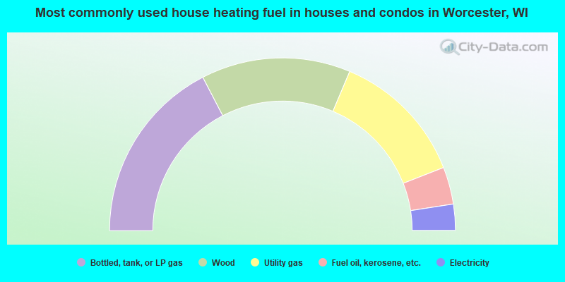
- 34.8%Bottled, tank, or LP gas
- 28.0%Wood
- 25.4%Utility gas
- 7.0%Fuel oil, kerosene, etc.
- 4.9%Electricity
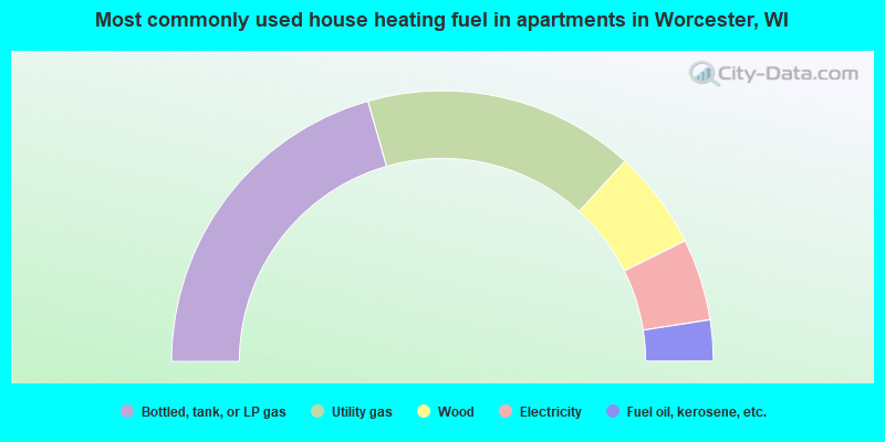
- 41.2%Bottled, tank, or LP gas
- 32.4%Utility gas
- 11.8%Wood
- 9.8%Electricity
- 4.9%Fuel oil, kerosene, etc.
Worcester compared to Wisconsin state average:
- Unemployed percentage below state average.
- Black race population percentage significantly below state average.
- Hispanic race population percentage significantly below state average.
- Median age above state average.
- Foreign-born population percentage significantly below state average.
- Renting percentage significantly below state average.
- Length of stay since moving in significantly above state average.
- Number of rooms per house significantly below state average.
- House age significantly below state average.
- Percentage of population with a bachelor's degree or higher below state average.