Wood River, Wisconsin
Submit your own pictures of this town and show them to the world
- OSM Map
- Google Map
- MSN Map
Population change since 2000: -2.2%
 |
| Males: 497 | |
| Females: 456 |
| Median resident age: | 44.0 years |
| Wisconsin median age: | 42.6 years |
Zip codes: 54840.
| Wood River: | $70,081 |
| WI: | $70,996 |
Estimated per capita income in 2022: $42,100 (it was $20,500 in 2000)
Wood River town income, earnings, and wages data
Estimated median house or condo value in 2022: $245,757 (it was $95,000 in 2000)
| Wood River: | $245,757 |
| WI: | $252,800 |
Detailed information about poverty and poor residents in Wood River, WI
Compare current foreclosures near Wood River, WI:
| Photo | Address | Area | Beds / Baths | Price | Details |
|---|---|---|---|---|---|

|
#1
Sand River Rd
Hinckley, MN 55037
|
1,296 sq. feet
|
1 baths 2 beds |
show details | |

|
#2
Beroun Crossing Rd
Pine City, MN 55063
|
1,188 sq. feet
|
2 baths 3 beds |
show details | |

|
#3
S 4th St
Luck, WI 54853
|
- sq. feet
|
1 baths 2 beds |
show details | |

|
#4
W Wisconsin Ave Apt 3
Grantsburg, WI 54840
|
- sq. feet
|
- baths - beds |
show details | |

|
#5
240th St
Cushing, WI 54006
|
- sq. feet
|
- baths - beds |
show details | |

|
#6
Maple Tree Ln
Pine City, MN 55063
|
- sq. feet
|
- baths - beds |
show details | |

|
#7
205th St
Luck, WI 54853
|
- sq. feet
|
- baths - beds |
show details | |

|
#8
Wilderness Retreat
Pine City, MN 55063
|
- sq. feet
|
- baths - beds |
show details | |

|
#9
W Wisconsin Ave
Grantsburg, WI 54840
|
- sq. feet
|
- baths - beds |
show details | |

|
#10
E North Ave
Luck, WI 54853
|
- sq. feet
|
- baths - beds |
show details |
| Photo | Address | Area | Beds / Baths | Price | Details |
|---|---|---|---|---|---|

|
#11
County Road D
Webster, WI 54893
|
- sq. feet
|
- baths - beds |
show details | |

|
#12
235th St
Cushing, WI 54006
|
- sq. feet
|
- baths - beds |
show details | |

|
#13
115th St
Frederic, WI 54837
|
- sq. feet
|
- baths - beds |
show details | |

|
#14
2nd Ave S
Frederic, WI 54837
|
- sq. feet
|
- baths - beds |
show details | |

|
#15
Washington St
Webster, WI 54893
|
- sq. feet
|
- baths - beds |
show details | |

|
#16
E Park Ave
Luck, WI 54853
|
- sq. feet
|
- baths - beds |
show details | |

|
#17
240th Ave
Luck, WI 54853
|
- sq. feet
|
- baths - beds |
show details | |

|
#18
5th Ave S
Frederic, WI 54837
|
- sq. feet
|
- baths - beds |
show details | |

|
#19
Lake Ave N
Frederic, WI 54837
|
- sq. feet
|
- baths - beds |
show details | |

|
#20
Wisconsin Ave N
Frederic, WI 54837
|
- sq. feet
|
- baths - beds |
show details |
| Photo | Address | Area | Beds / Baths | Price | Details |
|---|---|---|---|---|---|

|
#21
County Road Z
Frederic, WI 54837
|
- sq. feet
|
- baths - beds |
show details | |

|
#22
Lundeen Rd
Frederic, WI 54837
|
- sq. feet
|
- baths - beds |
show details | |

|
#23
200th St
Centuria, WI 54824
|
- sq. feet
|
- baths - beds |
show details | |

|
#24
2nd Ave SW
Milltown, WI 54858
|
- sq. feet
|
- baths - beds |
show details | |

|
Check over 1 million property listings on Foreclosure.com!
|
browse all offers | |||

- 90494.9%White alone
- 181.9%Hispanic
- 161.7%Two or more races
- 101.0%American Indian alone
- 40.4%Other race alone
- 10.1%Asian alone

Races in Wood River detailed stats: ancestries, foreign born residents, place of birth
 Recent articles from our blog. Our writers, many of them Ph.D. graduates or candidates, create easy-to-read articles on a wide variety of topics.
Ancestries: Swedish (29.8%), German (27.9%), Norwegian (22.6%), Irish (8.0%), English (6.8%), French (4.1%).
Current Local Time: CST time zone
Land area: 34.1 square miles.
Population density: 28 people per square mile (very low).
4 residents are foreign born
| This town: | 0.4% |
| Wisconsin: | 3.6% |
| Wood River town: | 1.5% ($1,454) |
| Wisconsin: | 2.0% ($2,245) |
Nearest city with pop. 50,000+: Coon Rapids, MN  (54.2 miles , pop. 61,607).
Nearest city with pop. 200,000+: St. Paul, MN (61.8 miles , pop. 287,151).
Nearest city with pop. 1,000,000+: Chicago, IL (365.2 miles , pop. 2,896,016).
Nearest cities:
), ), ), ), ), Latitude: 45.76 N, Longitude: 92.58 W
Area code commonly used in this area: 715

Single-family new house construction building permits:
- 2022: 2 buildings, average cost: $382,500
- 2021: 3 buildings, average cost: $244,800
- 2020: 5 buildings, average cost: $202,000
- 2019: 3 buildings, average cost: $125,700
- 2018: 2 buildings, average cost: $350,000
- 2017: 5 buildings, average cost: $200,000
- 2016: 2 buildings, average cost: $208,900
- 2015: 2 buildings, average cost: $100,000
- 2014: 1 building, cost: $100,000
- 2010: 2 buildings, average cost: $164,100


| Here: | 4.6% |
| Wisconsin: | 2.7% |

- Machinery (10.6%)
- Health care (9.8%)
- Construction (8.5%)
- Educational services (6.4%)
- Food (5.7%)
- Agriculture, forestry, fishing & hunting (5.5%)
- Accommodation & food services (5.3%)

- Construction (14.7%)
- Machinery (14.3%)
- Metal & metal products (7.8%)
- Food (7.5%)
- Agriculture, forestry, fishing & hunting (6.8%)
- Motor vehicle & parts dealers (3.3%)
- Wood products (2.9%)

- Health care (21.2%)
- Educational services (11.7%)
- Accommodation & food services (8.6%)
- Professional, scientific, technical services (5.4%)
- Machinery (5.4%)
- Social assistance (5.0%)
- Agriculture, forestry, fishing & hunting (3.6%)

- Metal workers and plastic workers (11.7%)
- Driver/sales workers and truck drivers (4.0%)
- Farmers and farm managers (3.2%)
- Secretaries and administrative assistants (3.2%)
- Construction traders workers except carpenters, electricians, painters, plumbers, and construction laborers (3.2%)
- Other management occupations, except farmers and farm managers (3.0%)
- Building and grounds cleaning and maintenance occupations (3.0%)

- Metal workers and plastic workers (18.6%)
- Driver/sales workers and truck drivers (6.2%)
- Construction traders workers except carpenters, electricians, painters, plumbers, and construction laborers (5.5%)
- Other production occupations, including supervisors (4.9%)
- Other management occupations, except farmers and farm managers (3.9%)
- Farmers and farm managers (3.6%)
- Other sales and related occupations, including supervisors (3.6%)

- Registered nurses (6.8%)
- Secretaries and administrative assistants (6.3%)
- Preschool, kindergarten, elementary, and middle school teachers (5.4%)
- Food and beverage serving workers, except waiters and waitresses (5.0%)
- Cooks and food preparation workers (5.0%)
- Other office and administrative support workers, including supervisors (4.5%)
- Child care workers (4.1%)
Average climate in Wood River, Wisconsin
Based on data reported by over 4,000 weather stations


(lower is better)

Air Quality Index (AQI) level in 2001 was 11.9. This is significantly better than average.
| City: | 11.9 |
| U.S.: | 72.6 |

Carbon Monoxide (CO) [ppm] level in 2001 was 0.194. This is better than average. Closest monitor was 16.0 miles away from the city center.
| City: | 0.194 |
| U.S.: | 0.251 |
Tornado activity:
Wood River-area historical tornado activity is slightly below Wisconsin state average. It is 17% smaller than the overall U.S. average.
On 5/21/1957, a category F4 (max. wind speeds 207-260 mph) tornado 14.4 miles away from the Wood River town center injured 2 people and caused between $5000 and $50,000 in damages.
On 6/18/2001, a category F3 (max. wind speeds 158-206 mph) tornado 3.6 miles away from the town center killed 2 people and injured 16 people and caused $10 million in damages.
Earthquake activity:
Wood River-area historical earthquake activity is significantly above Wisconsin state average. It is 61% smaller than the overall U.S. average.On 7/9/1975 at 14:54:15, a magnitude 4.6 (4.6 MB, Class: Light, Intensity: IV - V) earthquake occurred 167.3 miles away from Wood River center
On 6/5/1993 at 01:24:53, a magnitude 4.1 (4.1 LG, Depth: 6.2 mi) earthquake occurred 179.4 miles away from the city center
On 2/7/2020 at 18:30:28, a magnitude 3.3 (3.3 ML, Class: Light, Intensity: II - III) earthquake occurred 118.7 miles away from Wood River center
On 3/4/1983 at 06:32:18, a magnitude 4.6 (4.4 MB, 4.6 LG, 4.4 ML) earthquake occurred 350.8 miles away from Wood River center
On 1/9/2020 at 18:16:48, a magnitude 3.3 (3.3 MB) earthquake occurred 123.4 miles away from Wood River center
On 4/8/2020 at 17:14:33, a magnitude 3.3 (3.3 ML) earthquake occurred 124.8 miles away from Wood River center
Magnitude types: regional Lg-wave magnitude (LG), body-wave magnitude (MB), local magnitude (ML)
Natural disasters:
The number of natural disasters in Burnett County (9) is smaller than the US average (15).Major Disasters (Presidential) Declared: 6
Emergencies Declared: 3
Causes of natural disasters: Floods: 5, Storms: 4, Tornadoes: 2, Winds: 2, Drought: 1, Hurricane: 1, Other: 1 (Note: some incidents may be assigned to more than one category).
Colleges/universities with over 2000 students nearest to Wood River:
- Wisconsin Indianhead Technical College (about 33 miles; Shell Lake, WI; Full-time enrollment: 2,414)
- Century College (about 54 miles; White Bear Lake, MN; FT enrollment: 7,393)
- Anoka-Ramsey Community College (about 56 miles; Coon Rapids, MN; FT enrollment: 5,918)
- Bethel University (about 57 miles; Saint Paul, MN; FT enrollment: 4,061)
- University of Northwestern-St Paul (about 59 miles; Saint Paul, MN; FT enrollment: 2,680)
- North Hennepin Community College (about 60 miles; Brooklyn Park, MN; FT enrollment: 4,943)
- Metropolitan State University (about 61 miles; Saint Paul, MN; FT enrollment: 6,159)
Points of interest:
Churches in Wood River include: Midway Tabernacle (A), Wood River Church (B). Display/hide their locations on the map
Cemeteries: Anscarius Cemetery (1), Wood River Cemetery (2), Wood Lake Cemetery (3), Freya Cemetery (4). Display/hide their locations on the map
Lakes: Silver Lake (A), Muskrat Lake (B), Wood Lake (C), Indian Lake (D), Little Wood Lake (E). Display/hide their locations on the map
Creek: Wood Creek (A). Display/hide its location on the map
| This town: | 2.5 people |
| Wisconsin: | 2.4 people |
| This town: | 69.8% |
| Whole state: | 64.4% |
| This town: | 7.8% |
| Whole state: | 7.3% |
Likely homosexual households (counted as self-reported same-sex unmarried-partner households)
- Lesbian couples: 0.0% of all households
- Gay men: 0.3% of all households
| This town: | 6.9% |
| Whole state: | 8.7% |
| This town: | 2.9% |
| Whole state: | 3.7% |
For population 15 years and over in Wood River:

- Never married: 21.5%
- Now married: 65.3%
- Separated: 1.1%
- Widowed: 4.9%
- Divorced: 7.2%
For population 25 years and over in Wood River:
- High school or higher: 87.0%
- Bachelor's degree or higher: 16.1%
- Graduate or professional degree: 5.0%
- Unemployed: 4.2%
- Mean travel time to work (commute): 23.8 minutes


| Here: | 9.1 |
| Wisconsin average: | 11.0 |
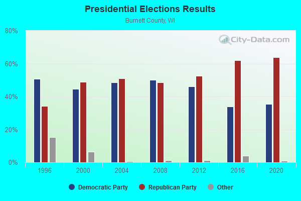
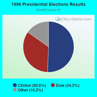
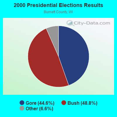
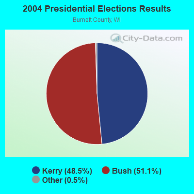
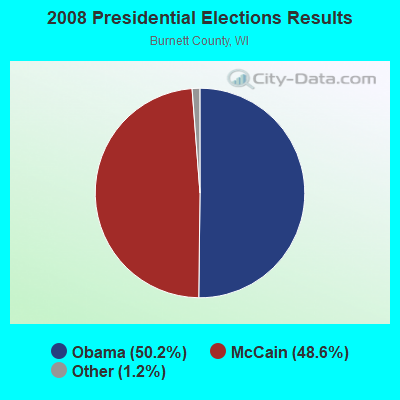
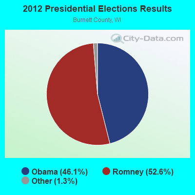
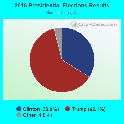
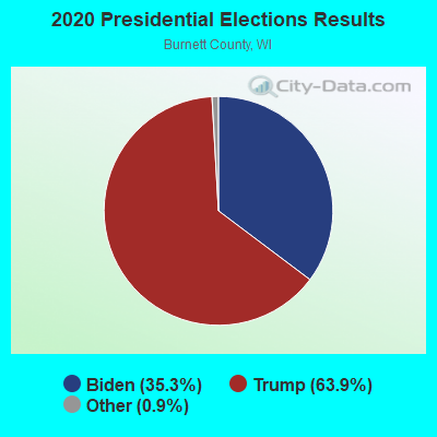
Graphs represent county-level data. Detailed 2008 Election Results
Religion statistics for Wood River, WI (based on Burnett County data)
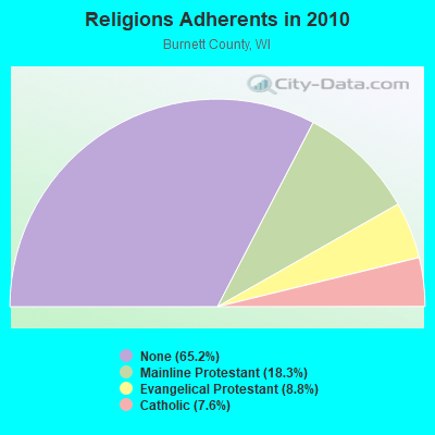
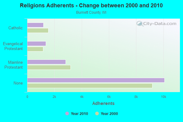
| Religion | Adherents | Congregations |
|---|---|---|
| Mainline Protestant | 2,829 | 13 |
| Evangelical Protestant | 1,361 | 14 |
| Catholic | 1,181 | 4 |
| Other | 1 | 1 |
| None | 10,085 | - |
Food Environment Statistics:
| Burnett County: | 3.68 / 10,000 pop. |
| State: | 1.86 / 10,000 pop. |
| Here: | 0.61 / 10,000 pop. |
| State: | 0.38 / 10,000 pop. |
| Burnett County: | 4.91 / 10,000 pop. |
| Wisconsin: | 4.12 / 10,000 pop. |
| Burnett County: | 16.58 / 10,000 pop. |
| Wisconsin: | 8.64 / 10,000 pop. |
| Burnett County: | 9.8% |
| State: | 7.6% |
| This county: | 28.3% |
| Wisconsin: | 27.5% |
| This county: | 14.0% |
| Wisconsin: | 13.0% |
Strongest AM radio stations in Wood River:
- WCCO (830 AM; 50 kW; MINNEAPOLIS, MN; Owner: INFINITY MEDIA CORPORATION)
- WEBC (560 AM; 50 kW; DULUTH, MN)
- WCTS (1030 AM; 50 kW; MAPLEWOOD, MN; Owner: CNTL. BAPT. THEO/AL SEMI MINNEAPOLIS)
- KSTP (1500 AM; 50 kW; ST. PAUL, MN; Owner: KSTP-AM, LLC (DELAWARE))
- KTIS (900 AM; 25 kW; MINNEAPOLIS, MN; Owner: NORTHWESTERN COLLEGE)
- KFAN (1130 AM; 50 kW; MINNEAPOLIS, MN; Owner: AMFM RADIO LICENSES, L.L.C.)
- WDGY (630 AM; 8 kW; HUDSON, WI; Owner: 630 RADIO, INCORPORATED)
- WDSM (710 AM; 10 kW; SUPERIOR, WI; Owner: MIDWEST COMMUNICATIONS, INC.)
- WXCE (1260 AM; 5 kW; AMERY, WI; Owner: LAKE COUNTRY BROADCASTING CORPORATION)
- WWJC (850 AM; daytime; 10 kW; DULUTH, MN; Owner: WWJC, INC.)
- WAQE (1090 AM; daytime; 5 kW; RICE LAKE, WI; Owner: TKC, INC.)
- WBHR (660 AM; 10 kW; SAUK RAPIDS, MN; Owner: HERBERT M. HOPPE)
- WMEQ (880 AM; 10 kW; MENOMONIE, WI; Owner: CAPSTAR TX LIMITED PARTNERSHIP)
Strongest FM radio stations in Wood River:
- WXCX (105.7 FM; SIREN, WI; Owner: QUARNSTROM MEDIA GROUP, LLC)
- WXPT (104.1 FM; ST. LOUIS PARK, MN; Owner: THE AUDIO HOUSE, INC.)
- WGMO (95.3 FM; SHELL LAKE, WI; Owner: ZOE COMMUNICATIONS, INC.)
- WCMP-FM (100.9 FM; PINE CITY, MN; Owner: QUARNSTROM MEDIA GROUP, LLC)
TV broadcast stations around Wood River:
- W24CL (Channel 24; GRANTSBURG, WI; Owner: STATE OF WISCONSIN - EDUCATIONAL COMMUNICATIONS BOARD)
- National Bridge Inventory (NBI) Statistics
- 8Number of bridges
- 26ft / 8.4mTotal length
- $235,000Total costs
- 5,165Total average daily traffic
- 216Total average daily truck traffic
- 8,737Total future (year 2039) average daily traffic

- 56.9%Bottled, tank, or LP gas
- 17.7%Wood
- 10.0%Fuel oil, kerosene, etc.
- 9.3%Electricity
- 6.1%Utility gas

- 54.1%Bottled, tank, or LP gas
- 20.3%Fuel oil, kerosene, etc.
- 12.2%Wood
- 10.8%Electricity
- 2.7%Utility gas
Wood River compared to Wisconsin state average:
- Unemployed percentage significantly below state average.
- Black race population percentage significantly below state average.
- Hispanic race population percentage significantly below state average.
- Foreign-born population percentage significantly below state average.
- Renting percentage below state average.
- Length of stay since moving in significantly above state average.
- Number of rooms per house significantly below state average.
- House age significantly below state average.
- Number of college students below state average.