Wingville, Oregon
Submit your own pictures of this place and show them to the world
- OSM Map
- General Map
- Google Map
- MSN Map

| Males: 942 | |
| Females: 900 |
| Median resident age: | 43.3 years |
| Oregon median age: | 36.3 years |
Zip code: 97814
| Wingville: | $65,033 |
| OR: | $75,657 |
Estimated per capita income in 2022: $41,232 (it was $19,392 in 2000)
Wingville CCD income, earnings, and wages data
Estimated median house or condo value in 2022: $415,992 (it was $142,200 in 2000)
| Wingville: | $415,992 |
| OR: | $475,600 |
Mean prices in 2022: all housing units: $339,228; detached houses: $346,395; townhouses or other attached units: $334,037; in 5-or-more-unit structures: $236,336; mobile homes: $301,620; occupied boats, rvs, vans, etc.: $55,971
Detailed information about poverty and poor residents in Wingville, OR
Compare current foreclosures near Wingville, OR:
| Photo | Address | Area | Beds / Baths | Price | Details |
|---|---|---|---|---|---|

|
#1
1st St
Haines, OR 97833
|
1,260 sq. feet
|
2 baths 2 beds |
show details | |

|
#2
15th St
Baker City, OR 97814
|
1,955 sq. feet
|
1 baths 4 beds |
show details | |

|
#3
Auburn Ave
Baker City, OR 97814
|
1,011 sq. feet
|
1 baths 2 beds |
show details | |

|
#4
Miller Ave
Baker City, OR 97814
|
1,328 sq. feet
|
1 baths 3 beds |
show details | |

|
#5
18th St
Baker City, OR 97814
|
- sq. feet
|
- baths - beds |
show details | |

|
#6
10th St
Baker City, OR 97814
|
2,862 sq. feet
|
- baths - beds |
show details | |

|
#7
F St
Baker City, OR 97814
|
2,057 sq. feet
|
- baths - beds |
show details | |

|
Check over 1 million property listings on Foreclosure.com!
|
browse all offers | |||

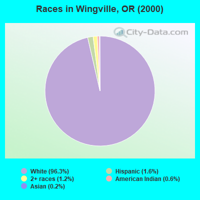
- 1,85396.3%White alone
- 311.6%Hispanic
- 231.2%Two or more races
- 120.6%American Indian alone
- 30.2%Asian alone
- 10.05%Black alone
- 10.05%Other race alone
Races in Wingville detailed stats: ancestries, foreign born residents, place of birth
 Recent articles from our blog. Our writers, many of them Ph.D. graduates or candidates, create easy-to-read articles on a wide variety of topics.
Current Local Time: PST time zone
Elevation: 3399 feet
Land area: 256.7 square miles.
Population density: 7.2 people per square mile (very low).

| Wingville CCD: | 0.6% ($902) |
| Oregon: | 1.2% ($1,687) |
Nearest city with pop. 50,000+: Kennewick, WA  (105.6 miles , pop. 54,693).
Nearest city with pop. 200,000+: Northwest Clackamas, OR (225.8 miles , pop. 224,220).
Nearest city with pop. 1,000,000+: Los Angeles, CA (747.6 miles , pop. 3,694,820).
Nearest cities:
Latitude: 44.89 N, Longitude: 118.05 W
Area code commonly used in this area: 541

| Here: | 4.7% |
| Oregon: | 3.9% |
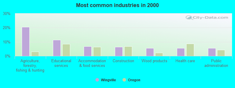
- Agriculture, forestry, fishing & hunting (20.5%)
- Educational services (11.4%)
- Accommodation & food services (6.8%)
- Construction (6.3%)
- Wood products (5.7%)
- Health care (5.7%)
- Public administration (5.5%)
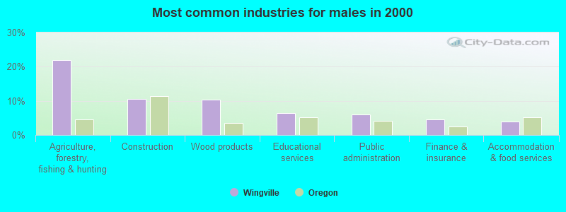
- Agriculture, forestry, fishing & hunting (22.0%)
- Construction (10.5%)
- Wood products (10.3%)
- Educational services (6.5%)
- Public administration (6.0%)
- Finance & insurance (4.6%)
- Accommodation & food services (3.8%)
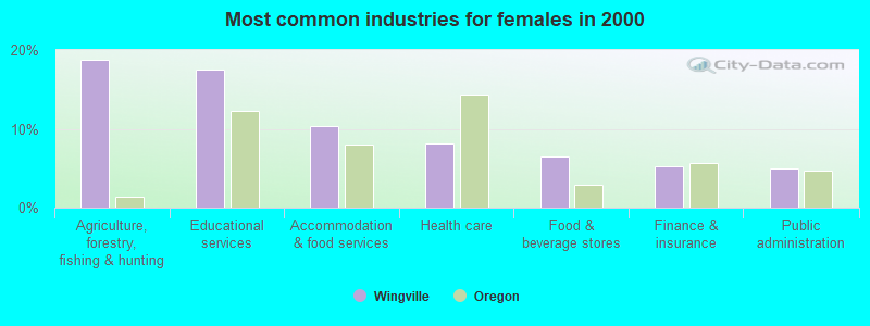
- Agriculture, forestry, fishing & hunting (18.8%)
- Educational services (17.5%)
- Accommodation & food services (10.4%)
- Health care (8.1%)
- Food & beverage stores (6.4%)
- Finance & insurance (5.2%)
- Public administration (4.9%)
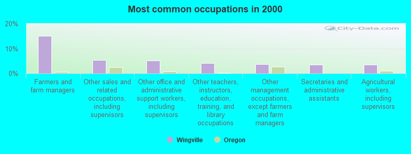
- Farmers and farm managers (15.1%)
- Other sales and related occupations, including supervisors (5.4%)
- Other office and administrative support workers, including supervisors (5.1%)
- Other teachers, instructors, education, training, and library occupations (4.1%)
- Other management occupations, except farmers and farm managers (3.7%)
- Secretaries and administrative assistants (3.6%)
- Agricultural workers, including supervisors (3.4%)
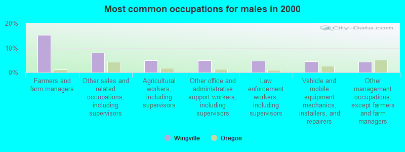
- Farmers and farm managers (15.3%)
- Other sales and related occupations, including supervisors (8.1%)
- Agricultural workers, including supervisors (5.0%)
- Other office and administrative support workers, including supervisors (5.0%)
- Law enforcement workers, including supervisors (4.8%)
- Vehicle and mobile equipment mechanics, installers, and repairers (4.6%)
- Other management occupations, except farmers and farm managers (4.2%)
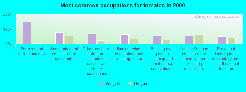
- Farmers and farm managers (14.8%)
- Secretaries and administrative assistants (7.9%)
- Other teachers, instructors, education, training, and library occupations (6.7%)
- Bookkeeping, accounting, and auditing clerks (6.4%)
- Building and grounds cleaning and maintenance occupations (5.4%)
- Other office and administrative support workers, including supervisors (5.2%)
- Preschool, kindergarten, elementary, and middle school teachers (4.9%)
Average climate in Wingville, Oregon
Based on data reported by over 4,000 weather stations


(lower is better)
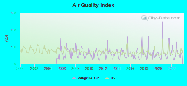
Air Quality Index (AQI) level in 2023 was 50.8. This is significantly better than average.
| City: | 50.8 |
| U.S.: | 72.6 |
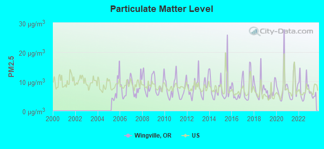
Particulate Matter (PM2.5) [µg/m3] level in 2023 was 5.38. This is significantly better than average. There were 0 monitors within city limits.
| City: | 5.38 |
| U.S.: | 8.11 |
Earthquake activity:
Wingville-area historical earthquake activity is significantly above Oregon state average. It is 1257% greater than the overall U.S. average.On 10/28/1983 at 14:06:06, a magnitude 7.3 (6.2 MB, 7.3 MS, 7.0 MW, Class: Major, Intensity: VIII - XII) earthquake occurred 216.8 miles away from the city center, causing 2 deaths (2 shaking deaths) and 3 injuries, causing $15,000,000 total damage
On 10/3/1915 at 06:52:48, a magnitude 7.6 (7.6 UK) earthquake occurred 305.0 miles away from the city center
On 8/18/1959 at 06:37:13, a magnitude 7.7 (7.7 UK) earthquake occurred 363.8 miles away from the city center, causing $26,000,000 total damage
On 3/31/2020 at 23:52:30, a magnitude 6.5 (6.5 MW, Depth: 7.5 mi, Class: Strong, Intensity: VII - IX) earthquake occurred 147.0 miles away from Wingville center
On 4/13/1949 at 19:55:42, a magnitude 7.0 (7.0 UK) earthquake occurred 268.8 miles away from Wingville center, causing $80,000,000 total damage
On 2/28/2001 at 18:54:32, a magnitude 6.8 (6.5 MB, 6.6 MS, 6.8 MW) earthquake occurred 265.6 miles away from Wingville center, causing $2,000,000,000 total damage and $305,000,000 insured losses
Magnitude types: body-wave magnitude (MB), surface-wave magnitude (MS), moment magnitude (MW)
Natural disasters:
The number of natural disasters in Baker County (7) is smaller than the US average (15).Major Disasters (Presidential) Declared: 4
Emergencies Declared: 2
Causes of natural disasters: Floods: 2, Winter Storms: 2, Drought: 1, Fire: 1, Heavy Rain: 1, Hurricane: 1, Other: 1 (Note: some incidents may be assigned to more than one category).
Hospitals and medical centers near Wingville:
- ST ALPHONSUS MEDICAL CENTER - BAKER CITY, INC Critical Access Hospitals (about 12 miles away; BAKER CITY, OR)
- TRINITY ST ELIZABETH HEALTH SERVICES, INC (Nursing Home, about 12 miles away; BAKER CITY, OR)
- L AND M CEDAR MANOR (Nursing Home, about 13 miles away; BAKER, OR)
- GUARDIAN HOME CARE (Home Health Center, about 14 miles away; BAKER CITY, OR)
Colleges/universities with over 2000 students nearest to Wingville:
- Eastern Oregon University (about 30 miles; La Grande, OR; Full-time enrollment: 3,127)
- Treasure Valley Community College (about 81 miles; Ontario, OR; FT enrollment: 2,055)
- Walla Walla Community College (about 83 miles; Walla Walla, WA; FT enrollment: 4,263)
- Columbia Basin College (about 108 miles; Pasco, WA; FT enrollment: 5,111)
- Lewis-Clark State College (about 117 miles; Lewiston, ID; FT enrollment: 3,199)
- College of Western Idaho (about 117 miles; Nampa, ID; FT enrollment: 6,300)
- Northwest Nazarene University (about 118 miles; Nampa, ID; FT enrollment: 2,290)
Points of interest:
Notable locations in Wingville: Malloy Cabin (A), Camp Lee (B), Dutch Flat Creek Trailhead (C), Killamacue Trailhead (D), Anthony Lakes Shoreline Recreation Site (E), Marble Creek Recreation Site (F), Anthony Lake Campground (G), Haines Stampede Rodeo Grounds (H), Rocky Ford Campground (I), Rock Creek Powerplant (J), Yankey Sawmill (K), Haines Fire Protection District Muddy Creek Road (L), Haines Fire Protection District Cole Road (M), Eastern Oregon Museum (N), Baker Rural Fire Protection District Pine Creek Lane (O), Haines 1800s Dick Camp Memorial Park (P), Haines City Hall (Q), Haines Public Works Department Office (R), Baker County Library Haines Branch Library (S). Display/hide their locations on the map
Cemeteries: Haines Cemetery (1), Rock Creek Cemetery (2), Wingville Cemetery (3). Display/hide their locations on the map
Lakes, reservoirs, and swamps: Goodrich Lake (A), Haines Pond Number One (B), Haines Pond Number Two (C), Hoffer Lakes (D), Killamacue Lake (E), Lilypad Lake (F), Little Summit Lake (G), Lost Lake (H). Display/hide their locations on the map
Streams, rivers, and creeks: Hutchinson Slough (A), Dutch Creek (B), Big Muddy Creek (C), Antone Creek (D), Anthony Creek (E), Bear Creek (F), Tibbs Creek (G), Birch Creek (H), Christensen Slough (I). Display/hide their locations on the map
Parks in Wingville include: Ebell Picnic Area (1), Elkhorn Wildlife Area (2). Display/hide their locations on the map
| This place: | 2.5 people |
| Oregon: | 2.5 people |
| This place: | 63.5% |
| Whole state: | 66.3% |
| This place: | 3.7% |
| Whole state: | 6.3% |
Likely homosexual households (counted as self-reported same-sex unmarried-partner households)
- Lesbian couples: 0.3% of all households
- Gay men: 0.4% of all households
| This place: | 12.2% |
| Whole state: | 11.6% |
| This place: | 5.8% |
| Whole state: | 5.0% |
4 people in hospices or homes for chronically ill in 2000
For population 15 years and over in Wingville:
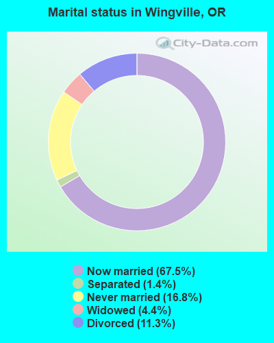
- Never married: 16.8%
- Now married: 67.5%
- Separated: 1.4%
- Widowed: 4.4%
- Divorced: 11.3%
For population 25 years and over in Wingville:
- High school or higher: 89.6%
- Bachelor's degree or higher: 25.5%
- Graduate or professional degree: 10.0%
- Unemployed: 3.5%
- Mean travel time to work (commute): 18.7 minutes
| Here: | 9.9 |
| Oregon average: | 11.5 |
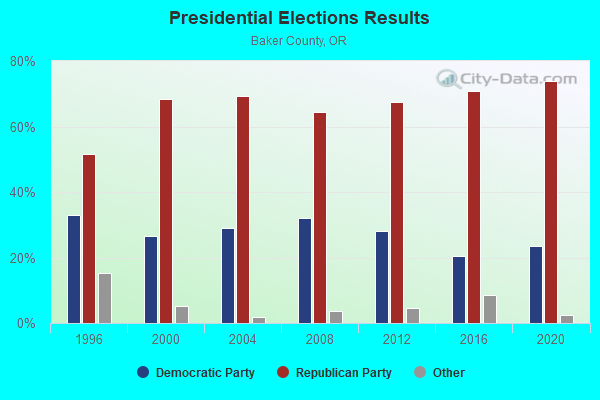
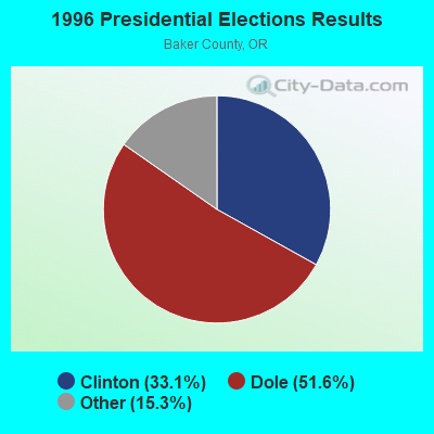
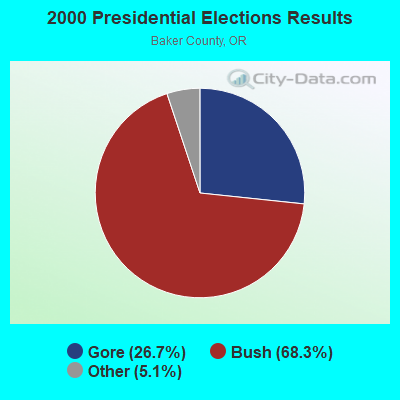
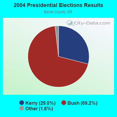
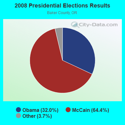
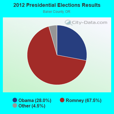
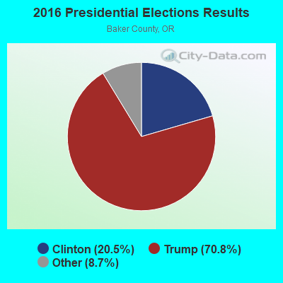
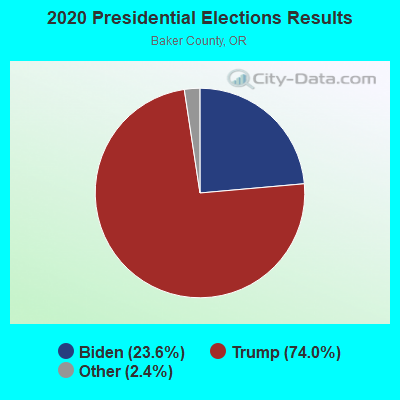
Graphs represent county-level data. Detailed 2008 Election Results
Religion statistics for Wingville, OR (based on Baker County data)
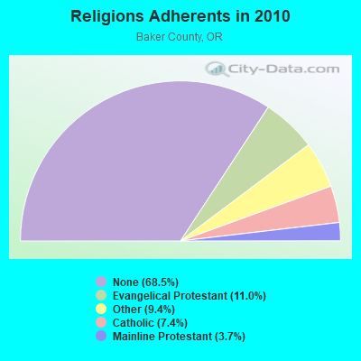
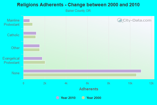
| Religion | Adherents | Congregations |
|---|---|---|
| Evangelical Protestant | 1,778 | 21 |
| Other | 1,515 | 8 |
| Catholic | 1,196 | 3 |
| Mainline Protestant | 595 | 6 |
| None | 11,050 | - |
Food Environment Statistics:
| This county: | 5.66 / 10,000 pop. |
| State: | 2.03 / 10,000 pop. |
| This county: | 0.63 / 10,000 pop. |
| Oregon: | 0.33 / 10,000 pop. |
| Baker County: | 1.26 / 10,000 pop. |
| Oregon: | 2.01 / 10,000 pop. |
| Baker County: | 4.40 / 10,000 pop. |
| Oregon: | 1.69 / 10,000 pop. |
| Here: | 13.20 / 10,000 pop. |
| State: | 9.93 / 10,000 pop. |
| Baker County: | 9.8% |
| State: | 7.4% |
| This county: | 25.3% |
| Oregon: | 25.6% |
| Baker County: | 13.0% |
| State: | 14.2% |
Strongest AM radio stations in Wingville:
- KWEI (1260 AM; 50 kW; WEISER, ID; Owner: TREASURE VALLEY BROADCASTING CO.)
- KBOI (670 AM; 50 kW; BOISE, ID; Owner: CITADEL BROADCASTING COMPANY)
- KBKR (1490 AM; 1 kW; BAKER, OR; Owner: GRANDE RADIO, INC.)
- KTBI (810 AM; daytime; 50 kW; EPHRATA, WA; Owner: TACOMA BROADCASTERS, INCORPORATED)
- KPOJ (620 AM; 50 kW; PORTLAND, OR; Owner: CITICASTERS LICENSES, L.P.)
- KXL (750 AM; 50 kW; PORTLAND, OR; Owner: ROSE CITY RADIO CORPORATION)
- KQQQ (1150 AM; 25 kW; PULLMAN, WA; Owner: RADIO PALOUSE, INC.)
- KBSU (730 AM; 15 kW; BOISE, ID; Owner: IDAHO STATE BOARD OF EDUCATION)
- KPAM (860 AM; 50 kW; TROUTDALE, OR; Owner: PAMPLIN BROADCASTING-OREGON, INC.)
- KGA (1510 AM; 50 kW; SPOKANE, WA; Owner: CITADEL BROADCASTING COMPANY)
- KFLD (870 AM; 10 kW; PASCO, WA; Owner: CAPSTAR TX LIMITED PARTNERSHIP)
- KUMA (1290 AM; 5 kW; PENDLETON, OR; Owner: ROUND-UP RADIO, INC.)
- KOTK (1080 AM; 50 kW; PORTLAND, OR; Owner: FISHER BROADCASTING - PORTLAND RADIO, L.L.C.)
Strongest FM radio stations in Wingville:
- KCMB (104.7 FM; BAKER, OR; Owner: OREGON TRAIL RADIO, INC.)
- K214CF (90.7 FM; BAKER, OR; Owner: AMERICAN FAMILY ASSOCIATION)
- KUBQ (98.7 FM; LA GRANDE, OR; Owner: GRANDE RADIO, INC.)
- K208DB (89.5 FM; ENTERPRISE, ETC., OR; Owner: WALLOWA VALLEY TV ASSOCIATION, INC.)
- K234AD (94.7 FM; ENTERPRISE, OR; Owner: WALLOWA VALLEY TV ASSOCIATION, INC.)
- KWRL (99.9 FM; LA GRANDE, OR; Owner: KSRV, INC.)
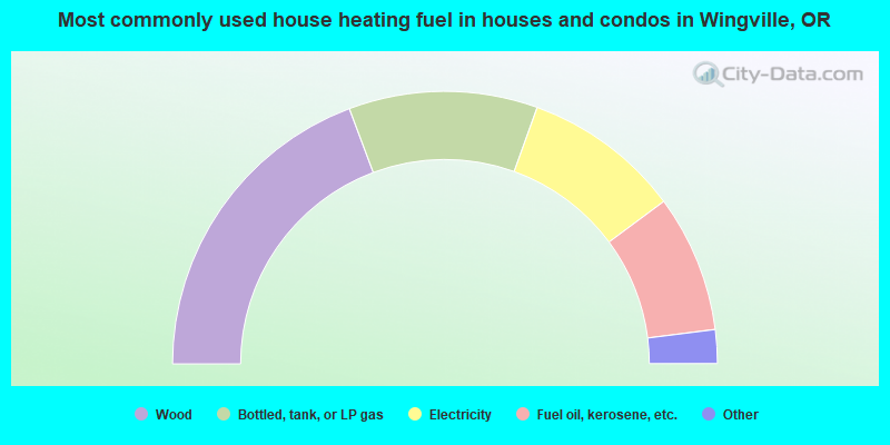
- 38.6%Wood
- 22.4%Bottled, tank, or LP gas
- 18.7%Electricity
- 16.3%Fuel oil, kerosene, etc.
- 1.8%Other fuel
- 1.7%Utility gas
- 0.5%No fuel used
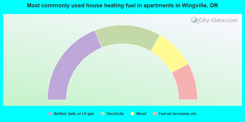
- 38.0%Bottled, tank, or LP gas
- 28.7%Electricity
- 17.3%Wood
- 16.0%Fuel oil, kerosene, etc.
Wingville compared to Oregon state average:
- Unemployed percentage significantly below state average.
- Black race population percentage significantly below state average.
- Hispanic race population percentage significantly below state average.
- Median age above state average.
- Foreign-born population percentage significantly below state average.
- Renting percentage significantly below state average.
- Length of stay since moving in significantly above state average.
- Number of rooms per house significantly below state average.
- House age significantly below state average.
- Institutionalized population percentage significantly above state average.
- Number of college students below state average.
Wingville on our top lists:
- #33 on the list of "Top 101 cities with the largest percentage of people in hospices or homes for chronically ill (population 1,000+)"
- #89 on the list of "Top 101 counties with highest percentage of residents voting for 3rd party candidates in the 2012 Presidential Election"