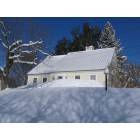
Estimated median house or condo value in 2022: $298,801 (it was $120,100 in 2000)
Wilmington:
$298,801
VT:
$304,700
Mean prices in 2022:all housing units: $298,935; detached houses: $317,292; townhouses or other attached units: $299,018; in 2-unit structures: $292,940; in 3-to-4-unit structures: $427,770; in 5-or-more-unit structures: $214,034; mobile homes: $65,502March 2022 cost of living index in Wilmington: 99.5 (near average, U.S. average is 100)
According to our research of Vermont and other state lists, there were 2 registered sex offenders living in Wilmington, Vermont as of May 03, 2024. The ratio of all residents to sex offenders in Wilmington is 938 to 1. The ratio of registered sex offenders to all residents in this city is lower than the state average.
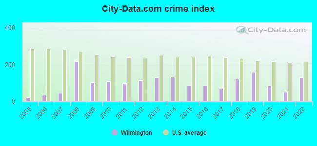
Crime rates in Wilmington by year
Type
2009
2010
2011
2012
2013
2014
2015
2016
2017
2018
2019
2020
2021
2022
Murders (per 100,000)
0 (0.0)
0 (0.0)
0 (0.0)
0 (0.0)
0 (0.0)
0 (0.0)
0 (0.0)
0 (0.0)
0 (0.0)
0 (0.0)
0 (0.0)
0 (0.0)
0 (0.0)
0 (0.0)
Rapes (per 100,000)
0 (0.0)
0 (0.0)
0 (0.0)
0 (0.0)
0 (0.0)
0 (0.0)
0 (0.0)
0 (0.0)
0 (0.0)
2 (111.4)
1 (55.5)
0 (0.0)
0 (0.0)
2 (86.6)
Robberies (per 100,000)
0 (0.0)
0 (0.0)
0 (0.0)
0 (0.0)
0 (0.0)
0 (0.0)
1 (54.5)
0 (0.0)
0 (0.0)
0 (0.0)
0 (0.0)
0 (0.0)
0 (0.0)
0 (0.0)
Assaults (per 100,000)
2 (85.1)
1 (53.3)
0 (0.0)
1 (53.6)
3 (162.5)
0 (0.0)
1 (54.5)
1 (54.8)
2 (110.7)
0 (0.0)
6 (333.1)
4 (223.8)
1 (56.3)
5 (216.5)
Burglaries (per 100,000)
9 (382.8)
18 (959.5)
6 (319.5)
10 (536.5)
11 (595.9)
17 (921.9)
11 (599.8)
5 (274.0)
3 (166.0)
2 (111.4)
3 (166.6)
2 (111.9)
1 (56.3)
0 (0.0)
Thefts (per 100,000)
33 (1,404)
15 (799.6)
29 (1,544)
25 (1,341)
24 (1,300)
29 (1,573)
8 (436.2)
21 (1,151)
15 (830.1)
7 (389.8)
7 (388.7)
5 (279.8)
10 (562.7)
8 (346.3)
Auto thefts (per 100,000)
1 (42.5)
0 (0.0)
3 (159.7)
3 (160.9)
1 (54.2)
1 (54.2)
0 (0.0)
3 (164.4)
1 (55.3)
2 (111.4)
5 (277.6)
5 (279.8)
3 (168.8)
1 (43.3)
Arson (per 100,000)
0 (0.0)
0 (0.0)
0 (0.0)
0 (0.0)
0 (0.0)
0 (0.0)
0 (0.0)
0 (0.0)
0 (0.0)
0 (0.0)
0 (0.0)
0 (0.0)
0 (0.0)
0 (0.0)
City-Data.com crime index
103.4
109.8
96.9
114.8
130.6
131.8
86.7
89.3
71.4
121.4
160.5
86.2
51.2
129.9
The City-Data.com crime index weighs serious crimes and violent crimes more heavily. Higher means more crime, U.S. average is 246.1. It adjusts for the number of visitors and daily workers commuting into cities.
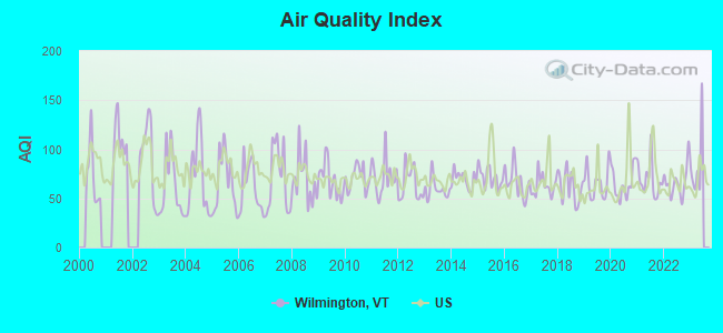
Air Quality Index (AQI) level in 2022 was 66.4. This is about average.
City:
66.4
U.S.:
72.6
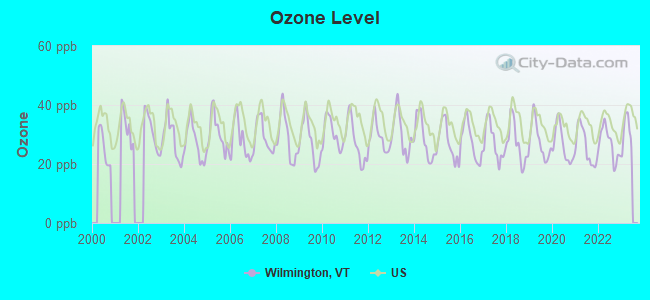
Ozone [ppb] level in 2022 was 26.9. This is better than average.Closest monitor was 10.3 miles away from the city center.
City:
26.9
U.S.:
33.3
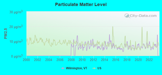
Particulate Matter (PM2.5) [µg/m3] level in 2022 was 6.11. This is better than average.Closest monitor was 16.1 miles away from the city center.
City:
6.11
U.S.:
8.11
Tornado activity:
Wilmington-area historical tornado activity is significantly above Vermont state average. It is 30% smaller than the overall U.S. average.
On 8/20/1968, a category F3 (max. wind speeds 158-206 mph) tornado 15.4 miles away from the Wilmington town center injured one personand causedbetween $5000 and $50,000 in damages.
On 5/31/1998, a category F3 tornado 16.2 miles away from the town center injured 68 peopleand caused $71 million in damages.
Earthquake activity:
Wilmington-area historical earthquake activity is significantly above Vermont state average. It is 69% smaller than the overall U.S. average.
On 10/7/1983 at 10:18:46, a magnitude 5.3 (5.1 MB, 5.3 LG, 5.1 ML, Class: Moderate, Intensity: VI - VII) earthquake occurred 104.7 miles away from the city center On 4/20/2002 at 10:50:47, a magnitude 5.3 (5.3 ML, Depth: 3.0 mi) earthquake occurred 120.1 miles away from the city center On 4/20/2002 at 10:50:47, a magnitude 5.2 (5.2 MB, 4.2 MS, 5.2 MW, 5.0 MW) earthquake occurred 118.8 miles away from Wilmington center On 1/19/1982 at 00:14:42, a magnitude 4.7 (4.5 MB, 4.7 MD, 4.5 LG, Class: Light, Intensity: IV - V) earthquake occurred 76.8 miles away from Wilmington center On 10/16/2012 at 23:12:25, a magnitude 4.7 (4.7 ML, Depth: 10.0 mi) earthquake occurred 121.9 miles away from Wilmington center On 6/17/1991 at 08:53:16, a magnitude 4.1 (4.0 MB, 4.0 LG, Depth: 3.1 mi) earthquake occurred 93.6 miles away from Wilmington center Magnitude types: regional Lg-wave magnitude (LG), body-wave magnitude (MB), duration magnitude (MD), local magnitude (ML), surface-wave magnitude (MS), moment magnitude (MW)
Natural disasters:
The number of natural disasters in Windham County (16) is near the US average (15). Major Disasters (Presidential) Declared: 13 Emergencies Declared: 2
Causes of natural disasters: Floods: 11, Storms: 10, Tropical Storms: 2, Hurricane: 1, Landslide: 1, Snowstorm: 1, Wind: 1, Winter Storm: 1 (Note: some incidents may be assigned to more than one category).
Hospitals and medical centers near Wilmington:
THOMPSON HOUSE NURSING HOME (Nursing Home, about 16 miles away; BRATTLEBORO, VT)
BRATTLEBORO MEMORIAL HOSPITAL Acute Care Hospitals (about 16 miles away; BRATTLEBORO, VT)
LINDEN LODGE NURSING HOME (Nursing Home, about 16 miles away; BRATTLEBORO, VT)
PINE HEIGHTS AT BRATTLEBORO CENTER FOR NURSING AND R (Nursing Home, about 16 miles away; BRATTLEBORO, VT)
SOUTHERN VERMONT HOME HEALTH (Home Health Center, about 16 miles away; BRATTLEBORO, VT)
Amtrak station near Wilmington:
17 miles: BRATTLEBORO (VERNON RD.) . Services: enclosed waiting area, public restrooms, call for car rental service, call for taxi service.
Operable nuclear power plant near Wilmington:
20 miles: Vermont Yankee in Vernon, VT.
Colleges/universities with over 2000 students nearest to Wilmington:
Williams College (about 21 miles; Williamstown, MA; Full-time enrollment: 2,141)
Keene State College (about 30 miles; Keene, NH; FT enrollment: 5,098)
University of Massachusetts-Amherst (about 39 miles; Amherst, MA; FT enrollment: 26,583)
Smith College (about 41 miles; Northampton, MA; FT enrollment: 3,549)
Franklin Pierce University (about 42 miles; Rindge, NH; FT enrollment: 2,139)
Rensselaer Polytechnic Institute (about 43 miles; Troy, NY; FT enrollment: 6,940)
The Sage Colleges (about 44 miles; Troy, NY; FT enrollment: 2,499)
PETTEE MEMORIAL (Operating income: $92,164; Location: 16 S. MAIN ST.; 9,946 books; 140 audio materials; 2,160 video materials; 1 local licensed databases; 19 state licensed databases; 21 print serial subscriptions)
User-submitted facts and corrections:
Secondary school in Wilmington is now Twin Valley High School, grades 9-12.
Notable locations in Wilmington: Wilmington Chamber of Commerce (A), Living History Association (B), Wilmington Fire Department (C). Display/hide their locations on the map
Churches in Wilmington include: Wilimngton Baptist Church (A), Wilmington Congregational Church (B), Our Lady of Fatima Catholic Church (C). Display/hide their locations on the map
Hotels: Nordic Hills Lodge (Coldbrook Rd), Hermitage Inn (Cold Brook Road), Inn at Quail Run (106 Smith Road), Viking Motel & Restaurant (East Main), Vintage Motel (195 Route 9 W), Horizon Inn- Mount Snow (PO Box 817), Misty Mountain Lodge (326 Stowe Hill Rd).
Birthplace of: James Manning Tyler - Politician.
Windham County has a predicted average indoor radon screening level between 2 and 4 pCi/L (pico curies per liter) - Moderate Potential
Drinking water stations with addresses in Wilmington and their reported violations in the past:
CHIMNEY HILL (Population served: 2,580, Groundwater):
Past health violations:
MCL, Monthly (TCR) - In AUG-2009, Contaminant: Coliform. Follow-up actions: St Boil Water Order (AUG-14-2009), St Formal NOV issued (AUG-14-2009), St Tech Assistance Visit (AUG-14-2009), St Public Notif requested (AUG-14-2009), St Compliance achieved (NOV-08-2010)
MCL, Acute (TCR) - In AUG-2007, Contaminant: Coliform. Follow-up actions: St Tech Assistance Visit (AUG-07-2007), St Formal NOV issued (AUG-07-2007), St Boil Water Order (AUG-07-2007), St Public Notif received (2 times from AUG-10-2007 to AUG-10-2007), St Compliance achieved (NOV-21-2008)
MCL, Monthly (TCR) - In OCT-2005, Contaminant: Coliform. Follow-up actions: St Formal NOV issued (OCT-14-2005), St Public Notif requested (OCT-14-2005), St Public Notif received (OCT-17-2005), St Compliance achieved (NOV-08-2010)
Past monitoring violations:
9 regular monitoring violations
WILMINGTON WATER DIST (Population served: 1,400, Surface water):
Past monitoring violations:
Follow-up Or Routine LCR Tap M/R - In OCT-01-2011, Contaminant: Lead and Copper Rule. Follow-up actions: St Formal NOV issued (FEB-21-2012), St Tech Assistance Visit (FEB-21-2012), St Public Notif requested (FEB-21-2012), St Public Notif received (JUN-15-2012)
Follow-up Or Routine LCR Tap M/R - In OCT-01-2010, Contaminant: Lead and Copper Rule. Follow-up actions: St Formal NOV issued (DEC-29-2010), St Public Notif requested (DEC-29-2010), St Tech Assistance Visit (DEC-29-2010)
Monitoring and Reporting (DBP) - Between APR-2008 and JUN-2008, Contaminant: Chlorine. Follow-up actions: St Public Notif requested (JAN-15-2009), St Formal NOV issued (JAN-15-2009), St Compliance achieved (FEB-18-2009), St Public Notif received (MAY-04-2009), St Compliance achieved (SEP-29-2009)
Monitoring and Reporting (DBP) - Between JAN-2008 and MAR-2008, Contaminant: Chlorine. Follow-up actions: St Public Notif requested (JUL-22-2008), St Formal NOV issued (JUL-22-2008), St Compliance achieved (FEB-18-2009), St Public Notif received (MAY-04-2009), St Compliance achieved (SEP-29-2009)
One regular monitoring violation
COLD BROOK FD BASE AREA (Address: 18 COLDBROOK RD UNIT 1 , Population served: 761, Groundwater):
Past health violations:
MCL, Monthly (TCR) - In JUN-2012, Contaminant: Coliform. Follow-up actions: St Public Notif requested (JUN-14-2012), St Formal NOV issued (JUN-14-2012), St Compliance achieved (AUG-08-2013)
Past monitoring violations:
Follow-up Or Routine LCR Tap M/R - In JAN-01-1997, Contaminant: Lead and Copper Rule. Follow-up actions: St Violation/Reminder Notice (JUL-01-1997), St Compliance achieved (APR-26-2011)
COLD BROOK FIRE DISTRICT 1 (Address: 18 COLDBROOK RD UNIT 1 , Population served: 700, Groundwater):
Past health violations:
MCL, Monthly (TCR) - In NOV-2013, Contaminant: Coliform. Follow-up actions: St Public Notif received (NOV-20-2013), St Compliance achieved (NOV-25-2013), St Public Notif requested (NOV-27-2013), St Tech Assistance Visit (NOV-27-2013), St Boil Water Order (NOV-27-2013), St Formal NOV issued (NOV-27-2013)
MCL, Monthly (TCR) - In JUN-2012, Contaminant: Coliform. Follow-up actions: St Public Notif requested (JUN-14-2012), St Formal NOV issued (JUN-14-2012), St Compliance achieved (AUG-08-2013)
SITZMARK LODGE (Address: 64 E DOVER RD , Population served: 325, Groundwater):
Past monitoring violations:
8 routine major monitoring violations
2 regular monitoring violations
TWIN VALLEY ELEMENTARY SCHOOL (Address: 360 ROUTE 100 N , Population served: 230, Groundwater):
Past monitoring violations:
Follow-up Or Routine LCR Tap M/R - In OCT-01-2006, Contaminant: Lead and Copper Rule. Follow-up actions: St Public Notif requested (DEC-04-2006), St Formal NOV issued (DEC-04-2006), St Public Notif received (JAN-25-2007), St Compliance achieved (APR-26-2011)
21 regular monitoring violations
WHITE HOUSE (Address: 27 STOWE HILL RD , Population served: 166, Groundwater):
Past monitoring violations:
Monitoring, Repeat Major (TCR) - Between JUL-2011 and SEP-2011, Contaminant: Coliform (TCR). Follow-up actions: St Public Notif requested (JAN-09-2012), St Formal NOV issued (JAN-09-2012), St Public Notif received (FEB-22-2012), St Compliance achieved (MAR-29-2013)
10 routine major monitoring violations
2 regular monitoring violations
HORIZON INN (Population served: 157, Groundwater):
Past monitoring violations:
3 routine major monitoring violations
Drinking water stations with addresses in Wilmington that have no violations reported:
DR RUHLS DENTISTRY OFFICE (Address: 25 COLDBROOK RD , Population served: 50,Primary Water Source Type: Groundwater)
CROSS COUNTRY (Address: 253 HAYNES RD , Population served: 40,Primary Water Source Type: Groundwater)
Average household size:
This town:
2.2 people
Vermont:
2.3 people
Percentage of family households:
This town:
58.0%
Whole state:
62.5%
Percentage of households with unmarried partners:
This town:
9.1%
Whole state:
9.2%
Likely homosexual households (counted as self-reported same-sex unmarried-partner households)
Lesbian couples: 0.5% of all households
Gay men: 0.8% of all households
Residents with income below the poverty level in 2009:
This town:
9.3%
Whole state:
9.4%
Residents with income below 50% of the poverty level in 2009:
This town:
3.6%
Whole state:
3.6%
Banks with branches in Wilmington (2011 data):
People's United Bank: Wilmington Branch at 29 East Main Street, branch established on 1935/05/01. Info updated 2012/02/16: Bank assets: $27,319.3 mil, Deposits: $20,835.4 mil, headquarters in Bridgeport, CT, positive income, Commercial Lending Specialization, 374 total offices
Merchants Bank: Wilmington Branch at 97 East Main Street, branch established on 1972/03/22. Info updated 2011/12/09: Bank assets: $1,615.1 mil, Deposits: $1,179.4 mil, headquarters in Burlington, VT, positive income, Commercial Lending Specialization, 34 total offices, Holding Company: Merchants Bancshares, Inc.
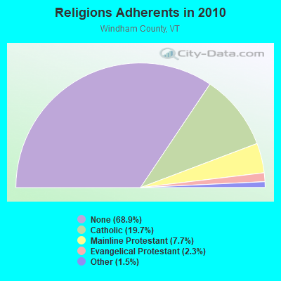
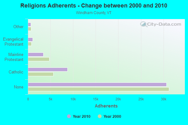
Religion statistics for Wilmington, VT (based on Windham County data)
Religion
Adherents
Congregations
Catholic
8,753
8
Mainline Protestant
3,412
38
Evangelical Protestant
1,026
13
Other
647
12
None
30,675
-
Source: Clifford Grammich, Kirk Hadaway, Richard Houseal, Dale E.Jones, Alexei Krindatch, Richie Stanley and Richard H.Taylor. 2012. 2010 U.S.Religion Census: Religious Congregations & Membership Study. Association of Statisticians of American Religious Bodies. Jones, Dale E., et al. 2002. Congregations and Membership in the United States 2000. Nashville, TN: Glenmary Research Center. Graphs represent county-level data
Rte 9 East Mt Olga (Lat: 42.850889 Lon: -72.803694), Overall height: 36.6 m, Call Sign: WPJD438, Assigned Frequencies: 21825.0 MHz, Grant Date: 01/17/1996, Expiration Date: 01/17/2001, Cancellation Date: 04/22/2001, Phone: (802) 464-4179
WILMINGTON, 3.8 Mi Ese Of Wilmington On Rt 9 (Lat: 42.854167 Lon: -72.802222), Type: Gtower, Structure height: 36.6 m, Overall height: 41.1 m, Call Sign: WPOR638, Assigned Frequencies: 6345.49 MHz, Grant Date: 01/30/2019, Expiration Date: 01/22/2029, Registrant: Wilkinson Barker Knauer, LLP, 1800 M Street Nw, Suite 800n, Washington, DC 20036, Phone: (202) 383-3420, Fax: (202) 783-5851, Email:
MT OLGA, Mt. Olga (Lat: 42.850556 Lon: -72.802861), Type: Gtower, Structure height: 24.4 m, Call Sign: WQXK576, Licensee ID: L00006600, Assigned Frequencies: 5945.20 MHz, Grant Date: 03/31/2016, Expiration Date: 03/31/2026, Certifier: Nghia H Lac, Registrant: National Grid Usa Service Company, Inc, 300 Erie Boulevard West, Syracuse, NY 13202, Phone: (781) 907-3409, Fax: (781) 907-5715, Email:
STATION, Mt Olga (Lat: 42.850889 Lon: -72.803139), Overall height: 26.8 m, Call Sign: KZW85, Assigned Frequencies: 6855.00 MHz, 6765.00 MHz, Grant Date: 02/04/2020, Expiration Date: 02/08/2030, Registrant: Utilities Technology Council, 2550 South Clark St., Suite 960, Arlington, VA 22202, Phone: (202) 872-0030, Fax: (202) 872-1331, Email:
FCC Registered Amateur Radio Licenses:
7
Call Sign: KA1LTC, Grant Date: 06/17/1994, Expiration Date: 06/17/2004, Cancellation Date: 06/20/2006, Registrant: Kevin G Robinson, Rt 1 Box 79 Ray Hill, Wilmington, VT 05363
Call Sign: KA2NHH, Grant Date: 04/18/1996, Expiration Date: 04/18/2006, Cancellation Date: 04/19/2008, Registrant: John A Bergquist, Wilmington, VT 05363
Call Sign: KB1AOA, Grant Date: 01/12/1993, Expiration Date: 01/12/2003, Cancellation Date: 01/13/2005, Registrant: Richard H Joyce, Rfd 1 Box 51, Wilmington, VT 05363
Call Sign: KC1MKJ, Licensee ID: L02314191, Grant Date: 12/26/2019, Expiration Date: 12/26/2029, Certifier: Thomas J Manton Jr, Registrant: Thomas J Manton Jr, 22 Manton Dr, Wilmington, VT 05363
Call Sign: KC1NWA, Licensee ID: L01553056, Grant Date: 09/21/2020, Expiration Date: 09/21/2030, Certifier: Christopher A Verry, Registrant: Christopher A Verry, Po Box 1869, Wilmington, VT 05363
Call Sign: KC1NZI, Licensee ID: L02383934, Grant Date: 10/13/2020, Expiration Date: 10/13/2030, Certifier: Joni W Massari, Registrant: Joni W Massari, 56 Tray Hill Rd, Wilmington, VT 05363
FAA Registered Aircraft:
1
Aircraft: CESSNA 150H (Category: Land, Seats: 2, Weight: Up to 12,499 Pounds, Speed: 90 mph), Engine: CONT MOTOR 0-200 SERIES (100 HP) (Reciprocating) N-Number: 22526, N22526, N-22526, Serial Number: 15068337, Year manufactured: 1968, Airworthiness Date: 02/29/1968, Certificate Issue Date: 08/18/2020 Registrant (Individual): Jason A Staloff, 256 Boyd Hill Rd, Wilmington, VT 05363
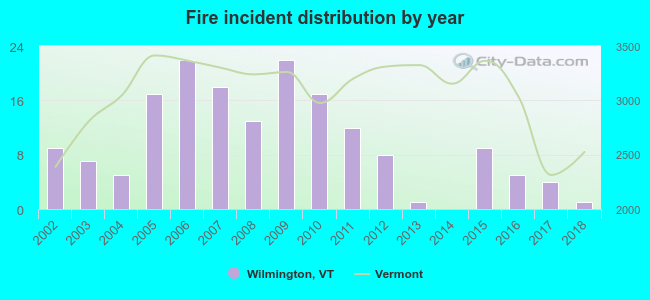
2002 - 2018 National Fire Incident Reporting System (NFIRS) incidents
According to the data from the years 2002 - 2018 the average number of fire incidents per year is 10. The highest number of reported fires - 22 took place in 2006, and the least - 0 in 2014. The data has a dropping trend.
When looking into fire subcategories, the most incidents belonged to: Structure Fires (54.7%), and Outside Fires (27.6%).
Fire incident types reported to NFIRS in Wilmington, VT


 Recent articles from our blog. Our writers, many of them Ph.D. graduates or candidates, create easy-to-read articles on a wide variety of topics.

 (48.9 miles


 According to the data from the years 2002 - 2018 the average number of fire incidents per year is 10. The highest number of reported fires - 22 took place in 2006, and the least - 0 in 2014. The data has a dropping trend.
 When looking into fire subcategories, the most incidents belonged to: Structure Fires (54.7%), and Outside Fires (27.6%).