Whitehall, West Virginia
Submit your own pictures of this town and show them to the world
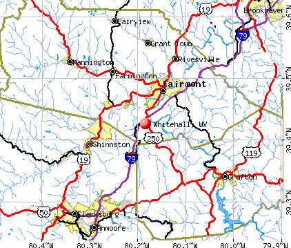
- OSM Map
- General Map
- Google Map
- MSN Map
Population change since 2000: +18.3%
 |
| Males: 384 | |
| Females: 320 |
| Median resident age: | 35.4 years |
| West Virginia median age: | 42.9 years |
Zip codes: 26554.
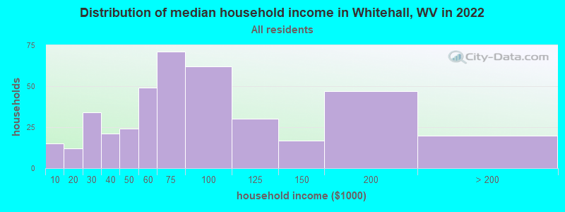
| Whitehall: | $66,591 |
| WV: | $54,329 |
Estimated per capita income in 2022: $36,364 (it was $21,188 in 2000)
Whitehall town income, earnings, and wages data
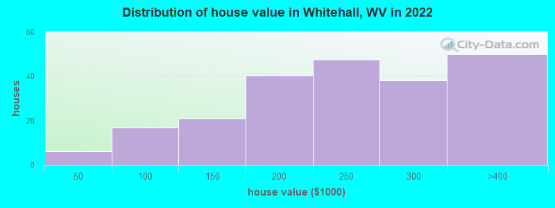
Estimated median house or condo value in 2022: $236,586 (it was $91,500 in 2000)
| Whitehall: | $236,586 |
| WV: | $155,100 |
Mean prices in 2022: all housing units: $227,704; detached houses: $248,146; townhouses or other attached units: $167,072; mobile homes: $57,701
Median gross rent in 2022: $963.
Detailed information about poverty and poor residents in Whitehall, WV


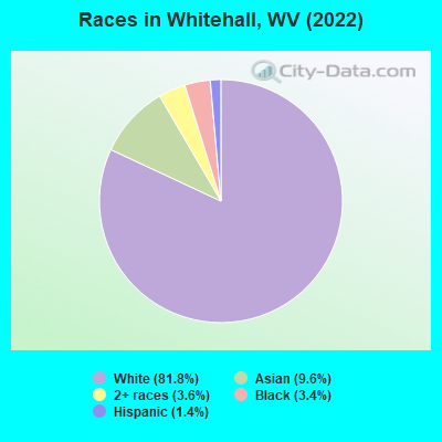
- 82981.8%White alone
- 979.6%Asian alone
- 363.6%Two or more races
- 343.4%Black alone
- 141.4%Hispanic
Races in Whitehall detailed stats: ancestries, foreign born residents, place of birth
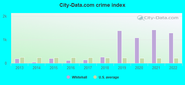
Type |
2013 |
2014 |
2015 |
2016 |
2017 |
2018 |
2019 |
2020 |
2021 |
2022 |
|---|---|---|---|---|---|---|---|---|---|---|
| Murders (per 100,000) | 0 (0.0) | 0 (0.0) | 0 (0.0) | 0 (0.0) | 0 (0.0) | 0 (0.0) | 0 (0.0) | 0 (0.0) | 0 (0.0) | 0 (0.0) |
| Rapes (per 100,000) | 0 (0.0) | 0 (0.0) | 1 (151.1) | 0 (0.0) | 0 (0.0) | 0 (0.0) | 0 (0.0) | 0 (0.0) | 0 (0.0) | 0 (0.0) |
| Robberies (per 100,000) | 1 (151.5) | 0 (0.0) | 0 (0.0) | 0 (0.0) | 1 (151.7) | 0 (0.0) | 0 (0.0) | 0 (0.0) | 0 (0.0) | 0 (0.0) |
| Assaults (per 100,000) | 3 (454.5) | 0 (0.0) | 1 (151.1) | 3 (451.1) | 1 (151.7) | 2 (302.6) | 6 (911.9) | 1 (149.9) | 0 (0.0) | 3 (425.5) |
| Burglaries (per 100,000) | 1 (151.5) | 0 (0.0) | 1 (151.1) | 1 (150.4) | 3 (455.2) | 0 (0.0) | 0 (0.0) | 2 (299.9) | 1 (149.9) | 2 (283.7) |
| Thefts (per 100,000) | 5 (757.6) | 7 (1,051) | 7 (1,057) | 4 (601.5) | 5 (758.7) | 32 (4,841) | 199 (30,243) | 168 (25,187) | 234 (35,082) | 209 (29,645) |
| Auto thefts (per 100,000) | 1 (151.5) | 1 (150.2) | 0 (0.0) | 0 (0.0) | 1 (151.7) | 1 (151.3) | 0 (0.0) | 2 (299.9) | 1 (149.9) | 0 (0.0) |
| Arson (per 100,000) | 0 (0.0) | 0 (0.0) | 0 (0.0) | 0 (0.0) | 0 (0.0) | 0 (0.0) | 0 (0.0) | 0 (0.0) | 0 (0.0) | 0 (0.0) |
| City-Data.com crime index | 189.4 | 54.1 | 203.9 | 124.8 | 150.2 | 266.3 | 1392.1 | 1082.5 | 1425.8 | 1290.8 |
The City-Data.com crime index weighs serious crimes and violent crimes more heavily. Higher means more crime, U.S. average is 246.1. It adjusts for the number of visitors and daily workers commuting into cities.
Crime rate in Whitehall detailed stats: murders, rapes, robberies, assaults, burglaries, thefts, arson
Full-time law enforcement employees in 2021, including police officers: 5 (5 officers - 5 male; 0 female).
| Officers per 1,000 residents here: | 7.50 |
| West Virginia average: | 1.95 |
 Recent articles from our blog. Our writers, many of them Ph.D. graduates or candidates, create easy-to-read articles on a wide variety of topics.

 | WVU News, Facilities, and Information (645 replies) |
| Renting in Morgantown or Surrounding (13 replies) |
| Morgantown Has Changed (80 replies) |
| Tech Park seeing big improvements, big plans! (81 replies) |
| Nice small towns outside of MorganTown??? (43 replies) |
| Looking for 3 bedroom rental property in Clarksburg/ Bridgeport/ Jane Lew (8 replies) |
Latest news from Whitehall, WV collected exclusively by city-data.com from local newspapers, TV, and radio stations
Ancestries: Irish (14.3%), English (12.7%), American (11.6%), Italian (11.3%), German (5.7%), British West Indian (2.5%).
Current Local Time: EST time zone
Incorporated on early 2000s
Elevation: 1200 feet
Land area: 0.95 square miles.
Population density: 739 people per square mile (low).
25 residents are foreign born (1.3% Asia, 1.0% Latin America).
| This town: | 2.5% |
| West Virginia: | 1.6% |
Median real estate property taxes paid for housing units with mortgages in 2022: $1,544 (0.6%)
Median real estate property taxes paid for housing units with no mortgage in 2022: $1,090 (0.6%)
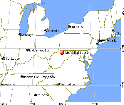
Nearest city with pop. 50,000+: Pittsburgh, PA  (71.1 miles , pop. 334,563).
Nearest city with pop. 1,000,000+: Philadelphia, PA (271.0 miles , pop. 1,517,550).
Nearest cities:
), ), ), Latitude: 39.43 N, Longitude: 80.18 W
Area code commonly used in this area: 304
| Here: | 4.0% |
| West Virginia: | 4.0% |
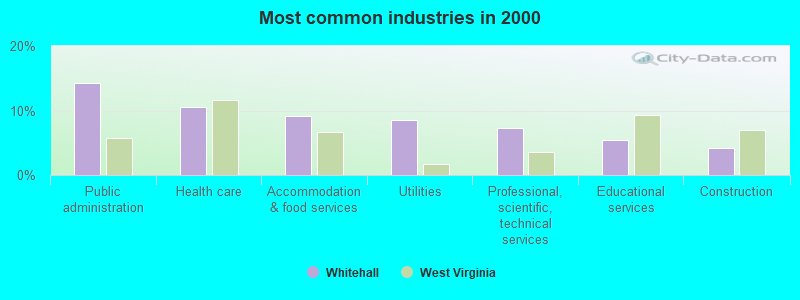
- Public administration (14.3%)
- Health care (10.5%)
- Accommodation & food services (9.2%)
- Utilities (8.6%)
- Professional, scientific, technical services (7.3%)
- Educational services (5.4%)
- Construction (4.1%)
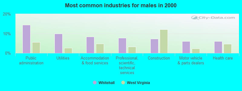
- Public administration (14.4%)
- Utilities (10.0%)
- Accommodation & food services (8.3%)
- Professional, scientific, technical services (7.8%)
- Construction (7.2%)
- Motor vehicle & parts dealers (6.1%)
- Health care (6.1%)
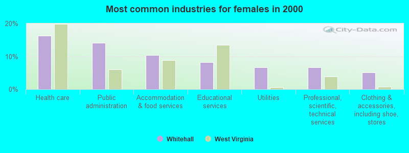
- Health care (16.3%)
- Public administration (14.1%)
- Accommodation & food services (10.4%)
- Educational services (8.1%)
- Utilities (6.7%)
- Professional, scientific, technical services (6.7%)
- Clothing & accessories, including shoe, stores (5.2%)
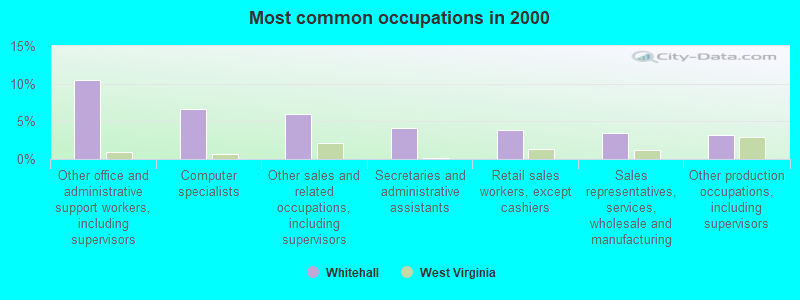
- Other office and administrative support workers, including supervisors (10.5%)
- Computer specialists (6.7%)
- Other sales and related occupations, including supervisors (6.0%)
- Secretaries and administrative assistants (4.1%)
- Retail sales workers, except cashiers (3.8%)
- Sales representatives, services, wholesale and manufacturing (3.5%)
- Other production occupations, including supervisors (3.2%)
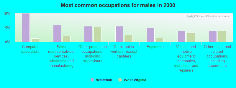
- Computer specialists (10.0%)
- Sales representatives, services, wholesale and manufacturing (6.1%)
- Other production occupations, including supervisors (5.6%)
- Retail sales workers, except cashiers (5.6%)
- Engineers (5.0%)
- Vehicle and mobile equipment mechanics, installers, and repairers (3.9%)
- Other sales and related occupations, including supervisors (3.9%)
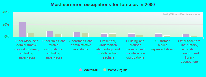
- Other office and administrative support workers, including supervisors (24.4%)
- Other sales and related occupations, including supervisors (8.9%)
- Secretaries and administrative assistants (8.1%)
- Preschool, kindergarten, elementary, and middle school teachers (5.2%)
- Building and grounds cleaning and maintenance occupations (5.2%)
- Customer service representatives (5.2%)
- Other teachers, instructors, education, training, and library occupations (4.4%)
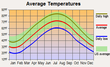
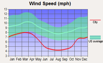
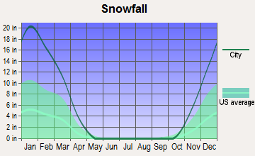
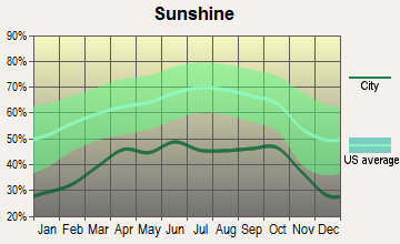
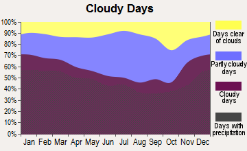
Average climate in Whitehall, West Virginia
Based on data reported by over 4,000 weather stations
(lower is better)
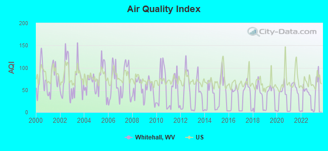
Air Quality Index (AQI) level in 2022 was 33.0. This is significantly better than average.
| City: | 33.0 |
| U.S.: | 72.6 |
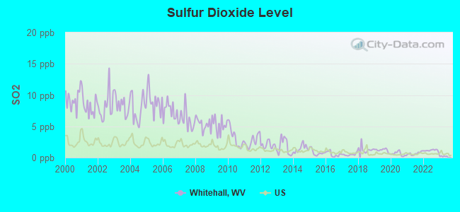
Sulfur Dioxide (SO2) [ppb] level in 2022 was 1.14. This is better than average. Closest monitor was 4.9 miles away from the city center.
| City: | 1.14 |
| U.S.: | 1.51 |
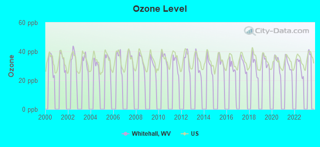
Ozone [ppb] level in 2022 was 29.4. This is about average. Closest monitor was 20.8 miles away from the city center.
| City: | 29.4 |
| U.S.: | 33.3 |
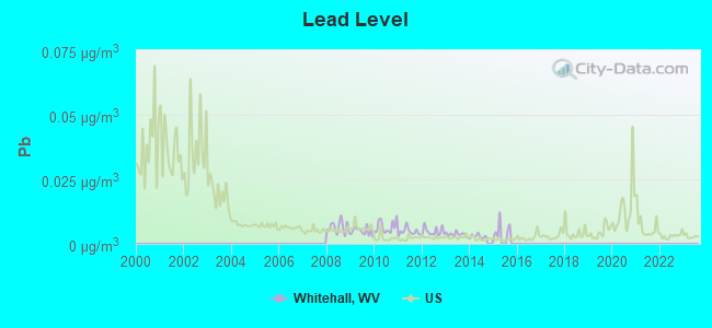
Lead (Pb) [µg/m3] level in 2014 was 0.00291. This is significantly better than average. Closest monitor was 4.9 miles away from the city center.
| City: | 0.00291 |
| U.S.: | 0.00931 |
Tornado activity:
Whitehall-area historical tornado activity is slightly above West Virginia state average. It is 63% smaller than the overall U.S. average.
On 6/3/1980, a category F3 (max. wind speeds 158-206 mph) tornado 16.8 miles away from the Whitehall town center injured 19 people and caused between $500,000 and $5,000,000 in damages.
On 10/1/1986, a category F3 tornado 33.1 miles away from the town center injured one person and caused between $50,000 and $500,000 in damages.
Earthquake activity:
Whitehall-area historical earthquake activity is significantly above West Virginia state average. It is 39% smaller than the overall U.S. average.On 8/23/2011 at 17:51:04, a magnitude 5.8 (5.8 MW, Depth: 3.7 mi, Class: Moderate, Intensity: VI - VII) earthquake occurred 160.4 miles away from the city center
On 9/25/1998 at 19:52:52, a magnitude 5.2 (4.8 MB, 4.3 MS, 5.2 LG, 4.5 MW, Depth: 3.1 mi) earthquake occurred 143.3 miles away from Whitehall center
On 1/31/1986 at 16:46:43, a magnitude 5.0 (5.0 MB) earthquake occurred 159.0 miles away from Whitehall center
On 7/27/1980 at 18:52:21, a magnitude 5.2 (5.1 MB, 4.7 MS, 5.0 UK, 5.2 UK) earthquake occurred 219.5 miles away from Whitehall center
On 8/9/2020 at 12:07:37, a magnitude 5.1 (5.1 MW, Depth: 4.7 mi) earthquake occurred 210.0 miles away from Whitehall center
On 8/25/2011 at 05:07:52, a magnitude 4.5 (4.5 ML, Depth: 4.2 mi, Class: Light, Intensity: IV - V) earthquake occurred 157.4 miles away from the city center
Magnitude types: regional Lg-wave magnitude (LG), body-wave magnitude (MB), local magnitude (ML), surface-wave magnitude (MS), moment magnitude (MW)
Natural disasters:
The number of natural disasters in Marion County (18) is near the US average (15).Major Disasters (Presidential) Declared: 13
Emergencies Declared: 4
Causes of natural disasters: Floods: 10, Storms: 10, Landslides: 5, Mudslides: 3, Tornadoes: 3, Winter Storms: 3, Hurricanes: 2, Blizzard: 1, Snowfall: 1, Snowstorm: 1, Other: 1 (Note: some incidents may be assigned to more than one category).

Hospitals and medical centers near Whitehall:
- ARBORS AT FAIRMONT (Nursing Home, about 3 miles away; FAIRMONT, WV)
- FAIRMONT GROUP HOME (Hospital, about 3 miles away; FAIRMONT, WV)
- PIERPONT CENTER AT FAIRMONT CAMPUS (Nursing Home, about 4 miles away; FAIRMONT, WV)
- FAIRMONT GENERAL HOSPITAL Acute Care Hospitals (about 5 miles away; FAIRMONT, WV)
- FAIRMONT GENERAL HOSPITAL HOME HEALTH (Home Health Center, about 6 miles away; FAIRMONT, WV)
- MEADOWVIEW MANOR HEALTH CARE (Nursing Home, about 10 miles away; BRIDGEPORT, WV)
- GRAFTON TAYLOR CO HEALTH DEPARTMENT HOME HEALTH (Home Health Center, about 10 miles away; GRAFTON, WV)
Colleges/universities with over 2000 students nearest to Whitehall:
- Fairmont State University (about 5 miles; Fairmont, WV; Full-time enrollment: 3,714)
- West Virginia University (about 19 miles; Morgantown, WV; FT enrollment: 27,429)
- Waynesburg University (about 33 miles; Waynesburg, PA; FT enrollment: 2,080)
- California University of Pennsylvania (about 48 miles; California, PA; FT enrollment: 7,773)
- West Liberty University (about 56 miles; West Liberty, WV; FT enrollment: 2,728)
- Westmoreland County Community College (about 65 miles; Youngwood, PA; FT enrollment: 4,669)
- Frostburg State University (about 69 miles; Frostburg, MD; FT enrollment: 4,944)
Points of interest:
Shopping Centers: Middletown Mall Shopping Center (1), Tygart Valley Mall Shopping Center (2). Display/hide their locations on the map
Church in Whitehall: White Hall Church of Christ (A). Display/hide its location on the map
| This town: | 2.2 people |
| West Virginia: | 2.4 people |
| This town: | 59.5% |
| Whole state: | 65.8% |
| This town: | 6.0% |
| Whole state: | 6.6% |
Likely homosexual households (counted as self-reported same-sex unmarried-partner households)
- Lesbian couples: 0.3% of all households
- Gay men: 0.0% of all households
For population 15 years and over in Whitehall:
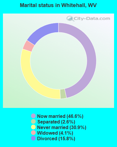
- Never married: 30.9%
- Now married: 46.6%
- Separated: 2.6%
- Widowed: 4.1%
- Divorced: 15.8%
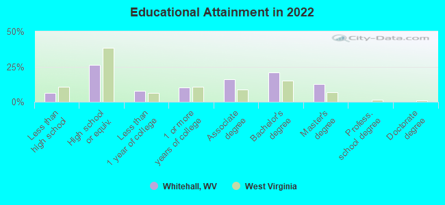
For population 25 years and over in Whitehall:
- High school or higher: 93.0%
- Bachelor's degree or higher: 31.2%
- Graduate or professional degree: 12.3%
- Unemployed: 4.3%
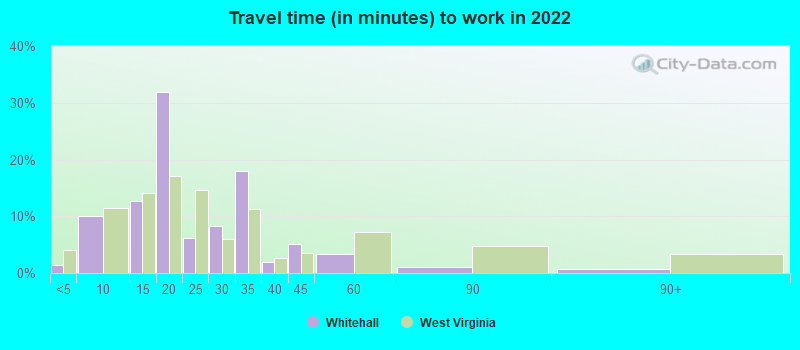
- Mean travel time to work (commute): 24.3 minutes
| Here: | 12.4 |
| West Virginia average: | 11.1 |
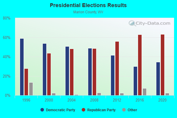
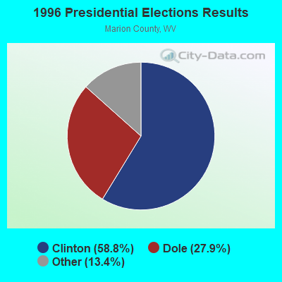
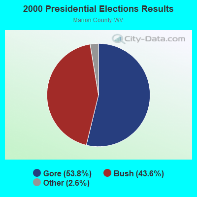
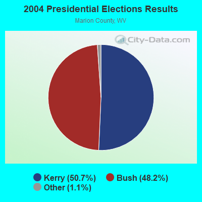
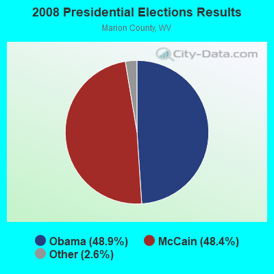
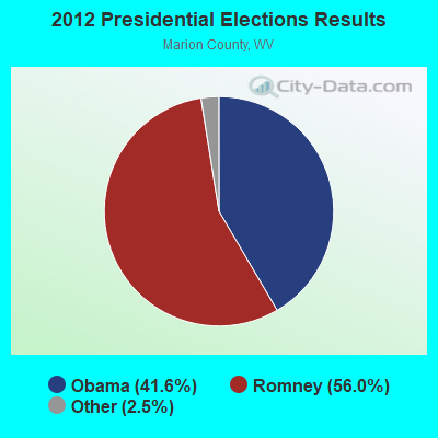
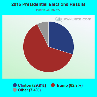
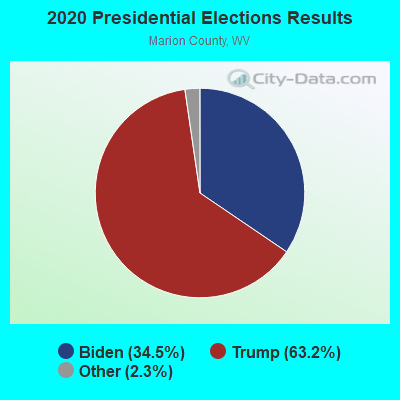
Graphs represent county-level data. Detailed 2008 Election Results
Religion statistics for Whitehall, WV (based on Marion County data)
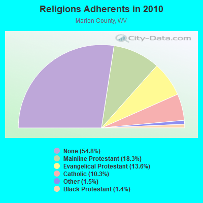
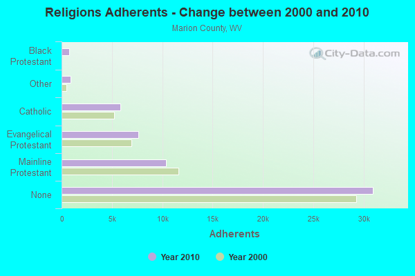
| Religion | Adherents | Congregations |
|---|---|---|
| Mainline Protestant | 10,344 | 73 |
| Evangelical Protestant | 7,649 | 55 |
| Catholic | 5,819 | 7 |
| Other | 873 | 3 |
| Black Protestant | 768 | 2 |
| Orthodox | 25 | 1 |
| None | 30,940 | - |
Food Environment Statistics:
| Marion County: | 1.77 / 10,000 pop. |
| West Virginia: | 2.41 / 10,000 pop. |
| This county: | 1.06 / 10,000 pop. |
| State: | 1.09 / 10,000 pop. |
| Here: | 5.82 / 10,000 pop. |
| West Virginia: | 5.38 / 10,000 pop. |
| This county: | 5.12 / 10,000 pop. |
| West Virginia: | 6.22 / 10,000 pop. |
| Here: | 10.0% |
| West Virginia: | 12.2% |
| Here: | 31.1% |
| State: | 31.1% |
| This county: | 11.6% |
| West Virginia: | 13.1% |
Health and Nutrition:
| This city: | 48.3% |
| State: | 51.8% |
| Whitehall: | 43.9% |
| West Virginia: | 49.7% |
| Whitehall: | 30.3 |
| State: | 28.6 |
| Whitehall: | 24.0% |
| West Virginia: | 20.4% |
| Whitehall: | 19.7% |
| State: | 9.7% |
| Here: | 6.8 |
| State: | 6.9 |
| This city: | 41.5% |
| State: | 34.8% |
| This city: | 53.5% |
| West Virginia: | 58.4% |
| Whitehall: | 78.5% |
| West Virginia: | 78.6% |
More about Health and Nutrition of Whitehall, WV Residents
| Local government employment and payroll (March 2007) | |||||
| Function | Full-time employees | Monthly full-time payroll | Average yearly full-time wage | Part-time employees | Monthly part-time payroll |
|---|---|---|---|---|---|
| Fire - Other | 0 | $0 | 0 | $0 | |
| Streets and Highways | 0 | $0 | 0 | $0 | |
| Welfare | 0 | $0 | 0 | $0 | |
| Health | 0 | $0 | 0 | $0 | |
| Hospitals | 0 | $0 | 0 | $0 | |
| Solid Waste Management | 0 | $0 | 0 | $0 | |
| Sewerage | 0 | $0 | 0 | $0 | |
| Parks and Recreation | 0 | $0 | 0 | $0 | |
| Water Supply | 0 | $0 | 0 | $0 | |
| Electric Power | 0 | $0 | 0 | $0 | |
| Local Libraries | 0 | $0 | 0 | $0 | |
| Other and Unallocable | 0 | $0 | 0 | $0 | |
| Financial Administration | 0 | $0 | 0 | $0 | |
| Other Government Administration | 0 | $0 | 8 | $2,315 | |
| Judicial and Legal | 0 | $0 | 0 | $0 | |
| Police Protection - Officers | 0 | $0 | 0 | $0 | |
| Police - Other | 0 | $0 | 0 | $0 | |
| Firefighters | 0 | $0 | 0 | $0 | |
| Totals for Government | 0 | $0 | 8 | $2,315 | |
Whitehall government finances - Expenditure in 2017 (per resident):
- Current Operations - Police Protection: $251,000 ($356.53)
Central Staff Services: $167,000 ($237.22)
Regular Highways: $137,000 ($194.60)
Parks and Recreation: $71,000 ($100.85)
Public Welfare - Other: $2,000 ($2.84)
Whitehall government finances - Revenue in 2017 (per resident):
- Charges - Other: $6,000 ($8.52)
- Miscellaneous - Fines and Forfeits: $68,000 ($96.59)
General Revenue - Other: $12,000 ($17.05)
Donations From Private Sources: $1,000 ($1.42)
- State Intergovernmental - Other: $3,000 ($4.26)
General Local Government Support: $2,000 ($2.84)
- Tax - Property: $175,000 ($248.58)
Other Selective Sales: $81,000 ($115.06)
Public Utilities Sales: $76,000 ($107.95)
Other License: $67,000 ($95.17)
Alcoholic Beverage Sales: $26,000 ($36.93)
Amusements Sales: $12,000 ($17.05)
Whitehall government finances - Debt in 2017 (per resident):
- Long Term Debt - Beginning Outstanding - Unspecified Public Purpose: $317,000 ($450.28)
Outstanding Unspecified Public Purpose: $303,000 ($430.40)
Retired Unspecified Public Purpose: $14,000 ($19.89)
Whitehall government finances - Cash and Securities in 2017 (per resident):
- Other Funds - Cash and Securities: $148,000 ($210.23)
Businesses in Whitehall, WV
- Advance Auto Parts: 1
- Fashion Bug: 1
- Ford: 1
Strongest AM radio stations in Whitehall:
- WMMN (920 AM; 5 kW; FAIRMONT, WV; Owner: FANTASIA BROADCASTING, INC.)
- WTCS (1490 AM; 1 kW; FAIRMONT, WV; Owner: FAIRMONT BROADCASTING COMPANY)
- WWVA (1170 AM; 53 kW; WHEELING, WV; Owner: CAPSTAR TX LIMITED PARTNERSHIP)
- WAJR (1440 AM; 5 kW; MORGANTOWN, WV; Owner: WEST VIRGINIA RADIO CORPORATION)
- KDKA (1020 AM; 50 kW; PITTSBURGH, PA; Owner: INFINITY BROADCASTING OPERATIONS, INC.)
- WCLG (1300 AM; 2 kW; MORGANTOWN, WV; Owner: BOWERS BROADCASTING CORP.)
- WOBG (1400 AM; 1 kW; CLARKSBURG, WV; Owner: BURBACH OF DE, LLC)
- WXKX (1340 AM; 1 kW; CLARKSBURG, WV; Owner: BURBACH OF DE, LLC)
- WTBZ (1260 AM; 0 kW; GRAFTON, WV; Owner: APPALACHIAN RADIO LLC)
- WPDX (750 AM; daytime; 1 kW; CLARKSBURG, WV; Owner: TSCHUDY BROADCASTING CORP.)
- WBUC (1460 AM; 5 kW; BUCKHANNON, WV; Owner: CAT RADIO, INC.)
- WTVN (610 AM; 50 kW; COLUMBUS, OH; Owner: CITICASTERS LICENSES, L.P.)
- WKNR (850 AM; 50 kW; CLEVELAND, OH; Owner: CARON BROADCASTING, INC.)
Strongest FM radio stations in Whitehall:
- WGYE (102.7 FM; MANNINGTON, WV; Owner: BURBACH OF DE, LLC)
- WRLF (94.3 FM; FAIRMONT, WV; Owner: FAIRMONT BROADCASTING COMPANY)
- WKKW (97.9 FM; FAIRMONT, WV; Owner: DESCENDANTS TRUST, LAUREN M.KELLEY, TRUSTEE)
- WBVQ (93.1 FM; BARRACKVILLE, WV; Owner: CAT RADIO, INC.)
- WGIE (92.7 FM; CLARKSBURG, WV; Owner: BURBACH OF DE, LLC)
- WKJL (88.1 FM; CLARKSBURG, WV; Owner: HE'S ALIVE, INC.)
- WZWA (90.1 FM; CLARKSBURG, WV; Owner: MARANATHA BROADCASTING, INC.)
- WDCI (104.1 FM; BRIDGEPORT, WV; Owner: WDCI RADIO, INC)
- W220BZ (91.9 FM; CLARKSBURG, WV; Owner: EDUCATIONAL MEDIA FOUNDATION)
- WAJR-FM (103.3 FM; SALEM, WV; Owner: WEST VIRGINIA RADIO CORPORATION OF SALEM)
- WVPM (90.9 FM; MORGANTOWN, WV; Owner: WEST VIRGINIA EDUCATIONAL BROADCASTING AUTHORITY)
- WOBG-FM (105.7 FM; SALEM, WV; Owner: BURBACH OF DE, LLC)
- WPDX-FM (104.9 FM; CLARKSBURG, WV; Owner: TSCHUDY BROADCASTING CORP.)
- WDKL (95.9 FM; GRAFTON, WV; Owner: EDUCATIONAL MEDIA FOUNDATION)
- WWLW (106.5 FM; CLARKSBURG, WV; Owner: WEST VIRGINIA RADIO CORPORATION OF CLARKSBURG)
- WVAQ (101.9 FM; MORGANTOWN, WV; Owner: WEST VIRGINIA RADIO CORPORATION)
- WDBS (97.1 FM; SUTTON, WV; Owner: SUMMIT MEDIA BROADCASTING, L.L.C.)
- WRIJ (106.9 FM; MASONTOWN, PA; Owner: HE'S ALIVE INC.)
- WOGG (94.9 FM; OLIVER, PA; Owner: KEYMARKET LICENSES, LLC)
- WBHZ (91.9 FM; ELKINS, WV; Owner: AMERICAN FAMILY ASSOCIATION)
TV broadcast stations around Whitehall:
- WVFX (Channel 46; CLARKSBURG, WV; Owner: DAVIS TELEVISION CLARKSBURG, LLC)
- WBOY-TV (Channel 12; CLARKSBURG, WV; Owner: WEST VIRGINIA MEDIA HOLDINGS, LLC)
- WDTV (Channel 5; WESTON, WV; Owner: WITHERS BROADCASTING COMPANY)
- WNPB-TV (Channel 24; MORGANTOWN, WV; Owner: WEST VIRGINIA EDUCATIONAL BROADCASTING AUTHORITY)
Whitehall fatal accident list:
Dec 22, 2010 07:15 AM, I-79, Lat: 39.421625, Lon: -80.198200, Vehicles: 1, Persons: 1, Fatalities: 1
Jan 22, 2008 10:03 AM, Us-250, Lat: 39.444110, Lon: -80.181750, Vehicles: 5, Persons: 6, Pedestrians: 1, Fatalities: 1
Sep 6, 1995 04:55 PM, I79, Vehicles: 2, Persons: 2, Fatalities: 1
Jun 15, 1990 02:20 AM, I79, Vehicles: 2, Persons: 2, Fatalities: 1, Drunk persons involved: 1
- National Bridge Inventory (NBI) Statistics
- 27Number of bridges
- 207ft / 62.9mTotal length
- $13,445,000Total costs
- 272,352Total average daily traffic
- 33,870Total average daily truck traffic
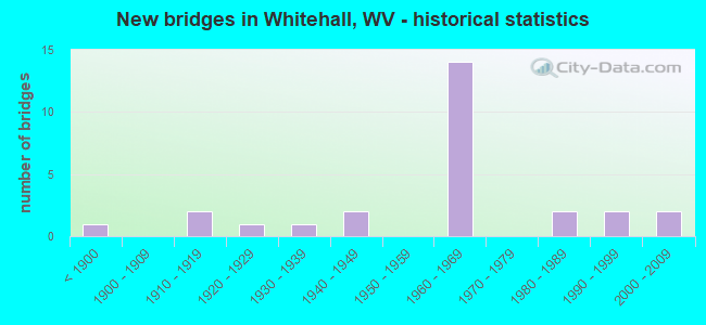
- New bridges - historical statistics
- 1Before 1900
- 21910-1919
- 11920-1929
- 11930-1939
- 21940-1949
- 141960-1969
- 21980-1989
- 21990-1999
- 22000-2009
FCC Registered Antenna Towers:
5- EARL JUDY, 7013 Mountain Park Drive (Lat: 39.418972 Lon: -80.181167), Type: 59.4, Overall height: 59.4 m, Registrant: Judy53jr@earthlink.Net, , Lurya, Phone: (540) 743-3000
- James E Eddy, Coal Bank Hill Road (Top Of Hill) (Lat: 39.419444 Lon: -80.167500), Type: 45.7, Overall height: 39.6 m, Registrant: Hardmans Wrecker Service L.L.C., Fairm-ont, Phone: (304) 366-5555
- SIGNATURE ON FILE, Coal Bank Hill Road (Top Of Hill) (Lat: 39.419444 Lon: -80.167500), Type: 45.7, Overall height: 39.6 m, Registrant: Hardmans Wrecker Service L.L.C., Fairm-ont, Phone: (304) 366-5555
- Earl Judy, 7013 Mountain Park Drive (Lat: 39.418972 Lon: -80.181167), Type: 59.4, Overall height: 59.4 m, Registrant: Judy53jr@earthlink.Net, , Lurya, Phone: (540) 743-3000
- Chris Egress, 7013 Mountain Park Drive (Lat: 39.418972 Lon: -80.181167), Type: 59.4, Structure height: 54049 m, Overall height: 59.4 m, Registrant: Judy53jr@earthlink.Net, , Luray, Phone: (540) 743-3000
FCC Registered Microwave Towers:
1- WHITE HALL, 7013 Mountain Park Drive (Lat: 39.418972 Lon: -80.181167), Type: Tower, Structure height: 59.4 m, Call Sign: WPQT280,
Assigned Frequencies: 949.125 MHz, Grant Date: 10/02/2000, Expiration Date: 10/01/2027, Cancellation Date: 12/09/2021, Certifier: Joyce M Jenkins, Registrant: Tschudy Broadcasting Corp., 15 Campbell Street, Luray, VA 22835, Phone: (540) 743-3000
FCC Registered Amateur Radio Licenses:
1- Call Sign: N8NPU, Licensee ID: L00336503, Grant Date: 04/02/2021, Expiration Date: 04/24/2031, Registrant: Jay C Holman Jr, 224 Queensbury Ct, Whitehall, WV 26554
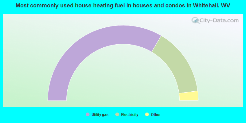
- 67.5%Utility gas
- 29.2%Electricity
- 2.4%Fuel oil, kerosene, etc.
- 1.0%Bottled, tank, or LP gas
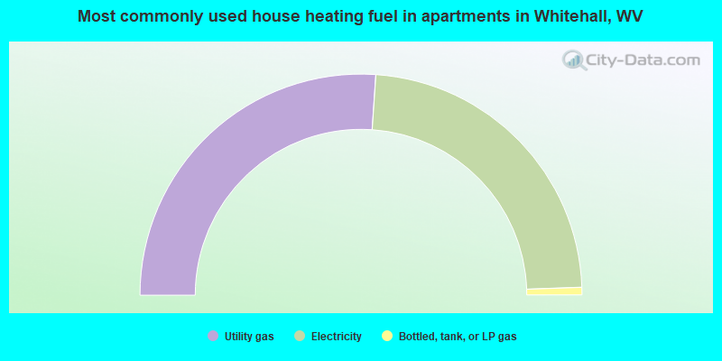
- 52.2%Utility gas
- 46.8%Electricity
- 1.1%Bottled, tank, or LP gas
Whitehall compared to West Virginia state average:
- Median house value above state average.
- Unemployed percentage significantly below state average.
- Black race population percentage above state average.
- Foreign-born population percentage significantly above state average.
- Renting percentage above state average.
- Length of stay since moving in below state average.
- House age significantly below state average.
- Number of college students above state average.
- Percentage of population with a bachelor's degree or higher above state average.