Westford, Wisconsin
Submit your own pictures of this town and show them to the world
- OSM Map
- Google Map
- MSN Map
Population change since 2000: -12.3%
| Males: 669 | |
| Females: 559 |
| Median resident age: | 48.7 years |
| Wisconsin median age: | 42.6 years |
Zip codes: 53916.
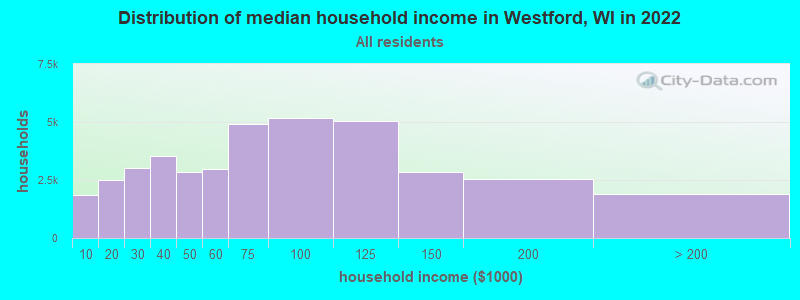
| Westford: | $72,749 |
| WI: | $70,996 |
Estimated per capita income in 2022: $40,141 (it was $22,582 in 2000)
Westford town income, earnings, and wages data
Estimated median house or condo value in 2022: $259,049 (it was $121,700 in 2000)
| Westford: | $259,049 |
| WI: | $252,800 |
Mean prices in 2022: all housing units: $261,408; detached houses: $272,121; townhouses or other attached units: $256,767; in 2-unit structures: $201,412; in 3-to-4-unit structures: $189,678; in 5-or-more-unit structures: $177,084; mobile homes: $51,673
Detailed information about poverty and poor residents in Westford, WI


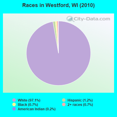
- 1,19397.1%White alone
- 151.2%Hispanic
- 90.7%Black alone
- 90.7%Two or more races
- 20.2%American Indian alone
Races in Westford detailed stats: ancestries, foreign born residents, place of birth
 Recent articles from our blog. Our writers, many of them Ph.D. graduates or candidates, create easy-to-read articles on a wide variety of topics.
Ancestries: German (56.9%), Irish (11.4%), Dutch (8.8%), Polish (8.6%), English (7.2%), Norwegian (5.3%).
Current Local Time: CST time zone
Land area: 30.2 square miles.
Population density: 41 people per square mile (very low).
23 residents are foreign born
| This town: | 1.6% |
| Wisconsin: | 3.6% |
| Westford town: | 1.9% ($2,272) |
| Wisconsin: | 2.0% ($2,245) |
Nearest city with pop. 50,000+: Madison, WI  (37.6 miles , pop. 208,054).
Nearest city with pop. 1,000,000+: Chicago, IL (132.4 miles , pop. 2,896,016).
Nearest cities:
), ), ), ), )Latitude: 43.51 N, Longitude: 88.95 W
Area code commonly used in this area: 920
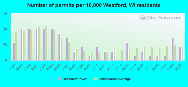
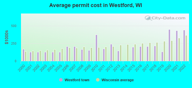
Single-family new house construction building permits:
- 2022: 3 buildings, average cost: $442,100
- 2021: 5 buildings, average cost: $434,200
- 2020: 1 building, cost: $450,000
- 2019: 1 building, cost: $135,000
- 2018: 1 building, cost: $214,500
- 2017: 2 buildings, average cost: $208,900
- 2016: 1 building, cost: $208,900
- 2015: 4 buildings, average cost: $201,500
- 2013: 2 buildings, average cost: $145,000
- 2012: 2 buildings, average cost: $240,000
- 2011: 3 buildings, average cost: $175,700
- 2010: 1 building, cost: $375,000
- 2009: 3 buildings, average cost: $155,700
- 2008: 2 buildings, average cost: $168,300
- 2007: 5 buildings, average cost: $208,500
- 2006: 6 buildings, average cost: $208,500
- 2005: 7 buildings, average cost: $130,400
- 2004: 7 buildings, average cost: $130,400
- 2003: 7 buildings, average cost: $130,400
- 2002: 7 buildings, average cost: $130,400
- 2001: 7 buildings, average cost: $130,400
- 2000: 4 buildings, average cost: $169,500
| Here: | 2.3% |
| Wisconsin: | 2.7% |
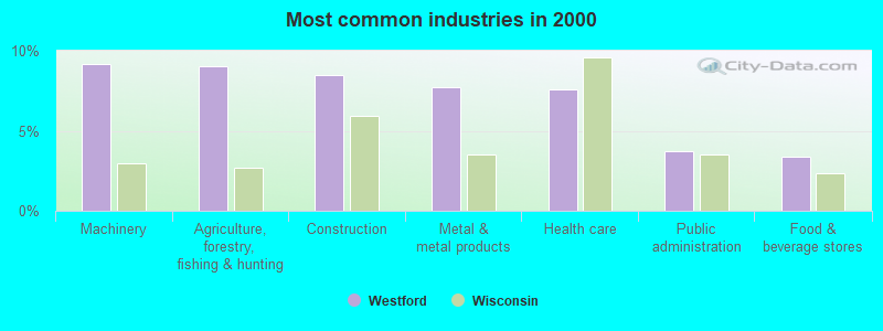
- Machinery (9.1%)
- Agriculture, forestry, fishing & hunting (9.0%)
- Construction (8.5%)
- Metal & metal products (7.7%)
- Health care (7.6%)
- Public administration (3.7%)
- Food & beverage stores (3.4%)
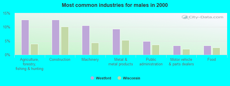
- Agriculture, forestry, fishing & hunting (12.6%)
- Construction (12.6%)
- Machinery (10.5%)
- Metal & metal products (9.3%)
- Public administration (4.9%)
- Motor vehicle & parts dealers (3.3%)
- Food (3.3%)
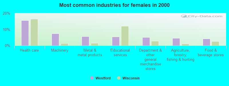
- Health care (15.5%)
- Machinery (7.5%)
- Metal & metal products (5.7%)
- Educational services (5.5%)
- Department & other general merchandise stores (5.2%)
- Agriculture, forestry, fishing & hunting (4.6%)
- Food & beverage stores (4.3%)
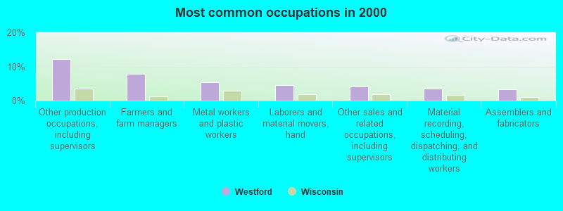
- Other production occupations, including supervisors (12.1%)
- Farmers and farm managers (7.9%)
- Metal workers and plastic workers (5.3%)
- Laborers and material movers, hand (4.5%)
- Other sales and related occupations, including supervisors (4.1%)
- Material recording, scheduling, dispatching, and distributing workers (3.6%)
- Assemblers and fabricators (3.4%)
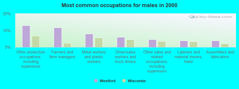
- Other production occupations, including supervisors (12.9%)
- Farmers and farm managers (11.7%)
- Metal workers and plastic workers (7.9%)
- Driver/sales workers and truck drivers (6.1%)
- Other sales and related occupations, including supervisors (4.7%)
- Laborers and material movers, hand (4.0%)
- Assemblers and fabricators (4.0%)

- Other production occupations, including supervisors (11.2%)
- Other office and administrative support workers, including supervisors (5.5%)
- Secretaries and administrative assistants (5.5%)
- Laborers and material movers, hand (5.2%)
- Material recording, scheduling, dispatching, and distributing workers (4.9%)
- Registered nurses (4.9%)
- Health technologists and technicians (4.9%)
Average climate in Westford, Wisconsin
Based on data reported by over 4,000 weather stations


(lower is better)
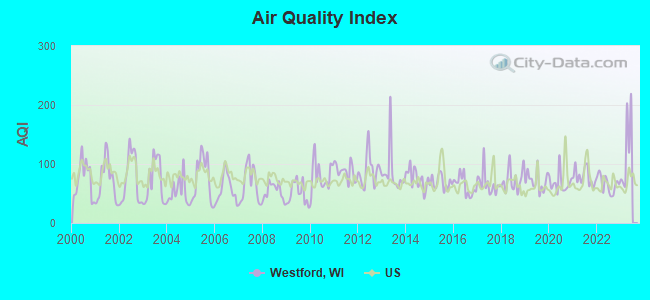
Air Quality Index (AQI) level in 2022 was 66.1. This is about average.
| City: | 66.1 |
| U.S.: | 72.6 |
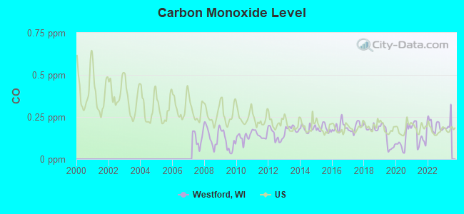
Carbon Monoxide (CO) [ppm] level in 2022 was 0.198. This is better than average. Closest monitor was 16.8 miles away from the city center.
| City: | 0.198 |
| U.S.: | 0.251 |
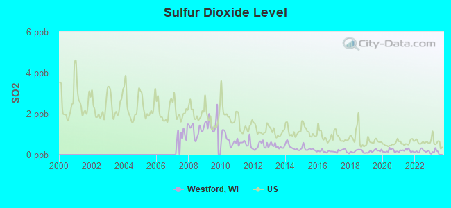
Sulfur Dioxide (SO2) [ppb] level in 2022 was 0.173. This is significantly better than average. Closest monitor was 15.0 miles away from the city center.
| City: | 0.173 |
| U.S.: | 1.515 |
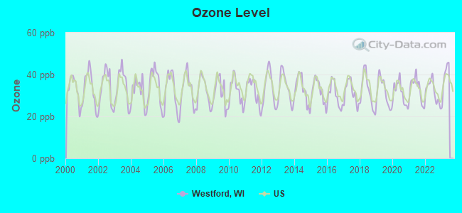
Ozone [ppb] level in 2022 was 31.9. This is about average. Closest monitor was 16.8 miles away from the city center.
| City: | 31.9 |
| U.S.: | 33.3 |
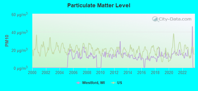
Particulate Matter (PM10) [µg/m3] level in 2022 was 14.1. This is better than average. Closest monitor was 16.8 miles away from the city center.
| City: | 14.1 |
| U.S.: | 19.2 |
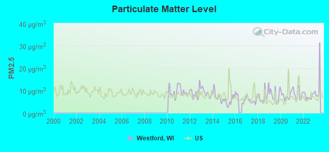
Particulate Matter (PM2.5) [µg/m3] level in 2022 was 7.50. This is about average. Closest monitor was 16.8 miles away from the city center.
| City: | 7.50 |
| U.S.: | 8.11 |
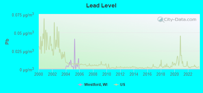
Lead (Pb) [µg/m3] level in 2005 was 0.0105. This is about average. Closest monitor was 21.9 miles away from the city center.
| City: | 0.0105 |
| U.S.: | 0.0093 |
Tornado activity:
Westford-area historical tornado activity is above Wisconsin state average. It is 73% greater than the overall U.S. average.
On 7/18/1996, a category F5 (max. wind speeds 261-318 mph) tornado 21.1 miles away from the Westford town center injured 12 people and caused $40 million in damages.
On 9/26/1951, a category F4 (max. wind speeds 207-260 mph) tornado 6.6 miles away from the town center killed one person and injured 9 people and caused between $50,000 and $500,000 in damages.
Earthquake activity:
Westford-area historical earthquake activity is significantly above Wisconsin state average. It is 16% greater than the overall U.S. average.On 4/18/2008 at 09:36:59, a magnitude 5.4 (5.1 MB, 4.8 MS, 5.4 MW, 5.2 MW, Class: Moderate, Intensity: VI - VII) earthquake occurred 354.3 miles away from Westford center
On 6/28/2004 at 06:10:52, a magnitude 4.2 (4.2 MW, Depth: 6.2 mi, Class: Light, Intensity: IV - V) earthquake occurred 141.9 miles away from the city center
On 6/10/1987 at 23:48:54, a magnitude 5.1 (4.9 MB, 4.4 MS, 4.6 MS, 5.1 LG) earthquake occurred 329.1 miles away from the city center
On 4/18/2008 at 09:36:59, a magnitude 5.2 (5.2 MW, Depth: 8.9 mi) earthquake occurred 354.3 miles away from the city center
On 2/10/2010 at 09:59:35, a magnitude 3.8 (3.8 MW, Depth: 6.2 mi, Class: Light, Intensity: II - III) earthquake occurred 109.1 miles away from the city center
On 5/2/2015 at 16:23:07, a magnitude 4.2 (4.2 MW, Depth: 2.8 mi) earthquake occurred 199.1 miles away from the city center
Magnitude types: regional Lg-wave magnitude (LG), body-wave magnitude (MB), surface-wave magnitude (MS), moment magnitude (MW)
Natural disasters:
The number of natural disasters in Dodge County (12) is smaller than the US average (15).Major Disasters (Presidential) Declared: 9
Emergencies Declared: 3
Causes of natural disasters: Floods: 6, Storms: 6, Tornadoes: 4, Drought: 1, Hurricane: 1, Snow: 1, Snowstorm: 1, Wind: 1, Winter Storm: 1, Other: 1 (Note: some incidents may be assigned to more than one category).
Hospitals and medical centers near Westford:
- BEAVER DAM COM HSPTL Acute Care Hospitals (about 8 miles away; BEAVER DAM, WI)
- HILLSIDE HOME CARE (Home Health Center, about 8 miles away; BEAVER DAM, WI)
- GOLDEN LIVINGCENTER-BEAVER DAM (Nursing Home, about 8 miles away; BEAVER DAM, WI)
- HILLSIDE MANOR (Nursing Home, about 8 miles away; BEAVER DAM, WI)
- BEAVER DAM DIALYSIS (Dialysis Facility, about 8 miles away; BEAVER DAM, WI)
- COLUMBUS COM HSPTL Critical Access Hospitals (about 9 miles away; COLUMBUS, WI)
- COLUMBUS CARE CENTER (Nursing Home, about 13 miles away; COLUMBUS, WI)
Colleges/universities with over 2000 students nearest to Westford:
- Herzing University-Madison (about 31 miles; Madison, WI; Full-time enrollment: 3,160)
- Marian University (about 33 miles; Fond Du Lac, WI; FT enrollment: 2,045)
- Moraine Park Technical College (about 33 miles; Fond du Lac, WI; FT enrollment: 3,079)
- Madison Area Technical College (about 34 miles; Madison, WI; FT enrollment: 9,603)
- University of Wisconsin-Madison (about 38 miles; Madison, WI; FT enrollment: 34,621)
- University of Wisconsin Colleges (about 39 miles; Madison, WI; FT enrollment: 10,019)
- Edgewood College (about 40 miles; Madison, WI; FT enrollment: 2,455)
Points of interest:
Notable location: Meagher Farms (A). Display/hide its location on the map
Cemeteries: Hall Cemetery (1), English Prairie Cemetery (2). Display/hide their locations on the map
Creek: Beaver Creek (A). Display/hide its location on the map
Park in Westford: Derge County Park (1). Display/hide its location on the map
| This town: | 2.4 people |
| Wisconsin: | 2.4 people |
| This town: | 73.9% |
| Whole state: | 64.4% |
| This town: | 7.2% |
| Whole state: | 7.3% |
Likely homosexual households (counted as self-reported same-sex unmarried-partner households)
- Lesbian couples: 0.6% of all households
- Gay men: 0.0% of all households
| This town: | 2.8% |
| Whole state: | 8.7% |
| This town: | 1.8% |
| Whole state: | 3.7% |
For population 15 years and over in Westford:
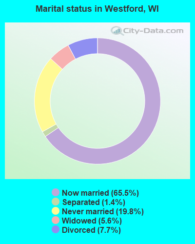
- Never married: 19.8%
- Now married: 65.5%
- Separated: 1.4%
- Widowed: 5.6%
- Divorced: 7.7%
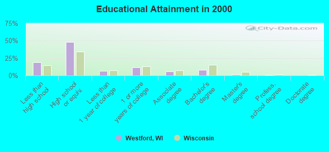
For population 25 years and over in Westford:
- High school or higher: 81.1%
- Bachelor's degree or higher: 10.0%
- Graduate or professional degree: 2.0%
- Unemployed: 3.6%
- Mean travel time to work (commute): 26.0 minutes
| Here: | 9.3 |
| Wisconsin average: | 11.0 |
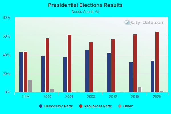
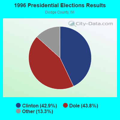
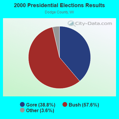
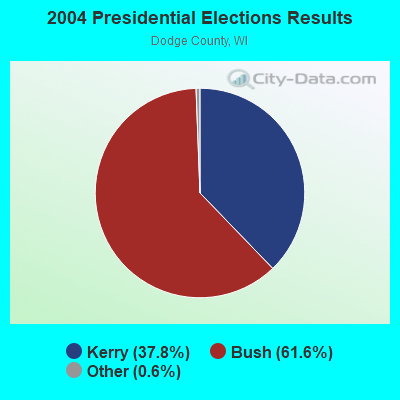
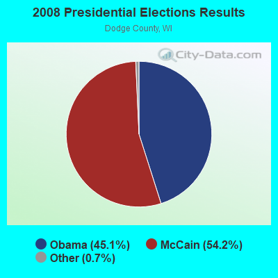
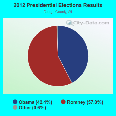
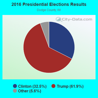
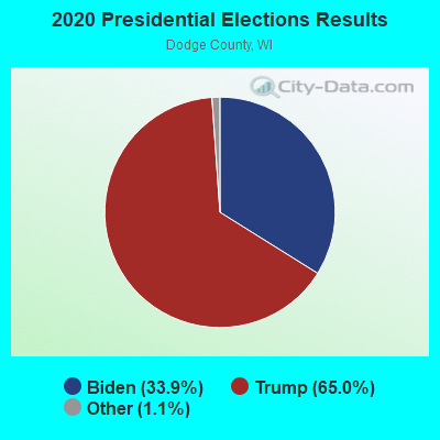
Graphs represent county-level data. Detailed 2008 Election Results
Religion statistics for Westford, WI (based on Dodge County data)
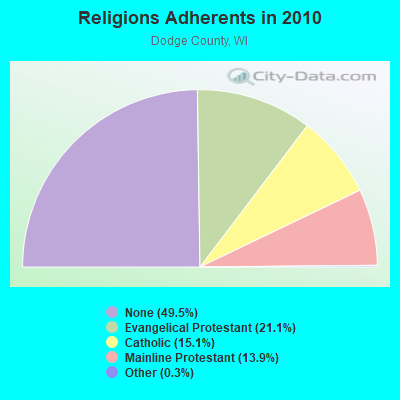
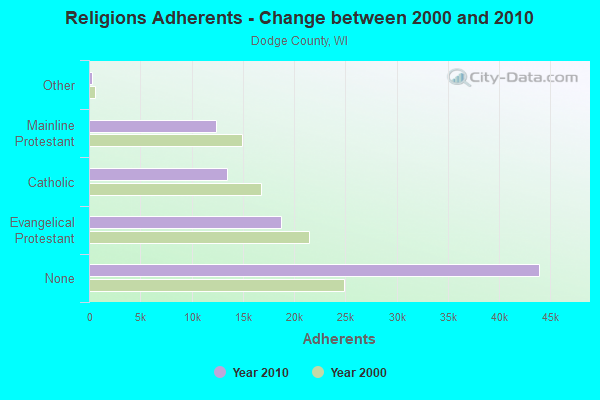
| Religion | Adherents | Congregations |
|---|---|---|
| Evangelical Protestant | 18,757 | 62 |
| Catholic | 13,437 | 13 |
| Mainline Protestant | 12,363 | 32 |
| Other | 265 | 2 |
| Orthodox | - | - |
| None | 43,937 | - |
Food Environment Statistics:
| Dodge County: | 1.48 / 10,000 pop. |
| State: | 1.86 / 10,000 pop. |
| This county: | 3.76 / 10,000 pop. |
| Wisconsin: | 4.12 / 10,000 pop. |
| Dodge County: | 6.84 / 10,000 pop. |
| Wisconsin: | 8.64 / 10,000 pop. |
| Dodge County: | 7.3% |
| State: | 7.6% |
| Here: | 28.8% |
| State: | 27.5% |
| This county: | 8.1% |
| State: | 13.0% |
Strongest AM radio stations in Westford:
- WBEV (1430 AM; 1 kW; BEAVER DAM, WI)
- WNAM (1280 AM; 50 kW; NEENAH-MENASHA, WI; Owner: CUMULUS LICENSING CORP.)
- WTMJ (620 AM; 50 kW; MILWAUKEE, WI; Owner: JOURNAL BROADCAST CORPORATION)
- WHBY (1150 AM; 25 kW; KIMBERLY, WI; Owner: WOODWARD COMMUNICATIONS, INC.)
- WISN (1130 AM; 50 kW; MILWAUKEE, WI; Owner: CAPSTAR TX LIMITED PARTNERSHIP)
- WSPT (1010 AM; 50 kW; STEVENS POINT, WI)
- WRPN (1600 AM; 5 kW; RIPON, WI)
- WTSO (1070 AM; 10 kW; MADISON, WI; Owner: CAPSTAR TX LIMITED PARTNERSHIP)
- WNWC (1190 AM; daytime; 5 kW; SUN PRAIRIE, WI; Owner: NORTHWESTERN COLLEGE)
- WGN (720 AM; 50 kW; CHICAGO, IL; Owner: WGN CONTINENTAL BROADCASTING CO.)
- WSCR (670 AM; 50 kW; CHICAGO, IL; Owner: INFINITY BROADCASTING OPERATIONS, INC.)
- WBBM (780 AM; 50 kW; CHICAGO, IL; Owner: INFINITY BROADCASTING OPERATIONS, INC.)
- WLMV (1480 AM; 10 kW; MADISON, WI; Owner: MID-WEST MANAGEMENT, INC.)
Strongest FM radio stations in Westford:
- WXRO (95.3 FM; BEAVER DAM, WI; Owner: GOOD KARMA BROADCASTING, L.L.C.)
- WTLX (100.5 FM; COLUMBUS, WI; Owner: GOOD KARMA BROADCASTING, L.L.C.)
- WOLX-FM (94.9 FM; BARABOO, WI; Owner: ENTERCOM MADISON LICENSE, LLC.)
- WJWD (90.3 FM; MARSHALL, WI; Owner: CSN INTERNATIONAL)
- WERN (88.7 FM; MADISON, WI; Owner: STATE OF WISCONSIN - EDUCATIONAL COMMUNICATIONS BOARD)
- WPKR (99.5 FM; OMRO, WI; Owner: MIDWEST DIMENSIONS, INC.)
- WZEE (104.1 FM; MADISON, WI; Owner: CAPSTAR TX LIMITED PARTNERSHIP)
- WIBA-FM (101.5 FM; MADISON, WI; Owner: CAPSTAR TX LIMITED PARTNERSHIP)
- WFDL-FM (97.7 FM; LOMIRA, WI; Owner: RADIO PLUS OF FOND DU LAC, INC.)
- WORT (89.9 FM; MADISON, WI; Owner: BACK PORCH RADIO BROADCASTING, INC.)
- WTCX (96.1 FM; RIPON, WI; Owner: RADIO B/C LTD PARTNERSHIP)
- WMDC (98.7 FM; MAYVILLE, WI; Owner: RADIO PLUS, INC.)
- WDDC (100.1 FM; PORTAGE, WI; Owner: ZOE COMMUNICATIONS, INC.)
- WBJZ (104.7 FM; BERLIN, WI; Owner: CAXAMBAS CORPORATION)
- WMAD-FM (92.1 FM; SUN PRAIRIE, WI; Owner: CAPSTAR TX LIMITED PARTNERSHIP)
TV broadcast stations around Westford:
- WWRS-TV (Channel 52; MAYVILLE, WI; Owner: NATIONAL MINORITY T.V., INC.)
- WMMF-TV (Channel 68; FOND DU LAC, WI; Owner: PAPPAS TELECASTING OF WISCONSIN, A CALIFORNIA LTD PARTNRSHP)
- WISC-TV (Channel 3; MADISON, WI; Owner: TELEVISION WISCONSIN, INC.)
- WMSN-TV (Channel 47; MADISON, WI; Owner: WMSN LICENSEE, LLC)
- WKOW-TV (Channel 27; MADISON, WI; Owner: WKOW TELEVISION, INC.)
- WHA-TV (Channel 21; MADISON, WI; Owner: BOARD OF REGENTS OF THE UNIV. OF WISCONSIN SYSTEM)
- WMTV (Channel 15; MADISON, WI; Owner: GRAY MIDAMERICA TV LICENSEE CORP.)
- National Bridge Inventory (NBI) Statistics
- 11Number of bridges
- 98ft / 30.3mTotal length
- 11,909Total average daily traffic
- 551Total average daily truck traffic
- 13,081Total future (year 2039) average daily traffic
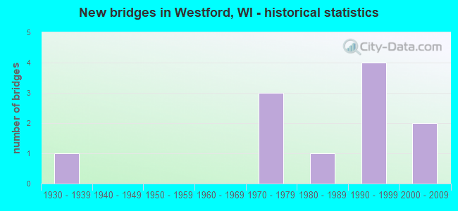
- New bridges - historical statistics
- 11930-1939
- 31970-1979
- 11980-1989
- 41990-1999
- 22000-2009
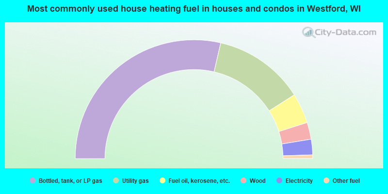
- 57.2%Bottled, tank, or LP gas
- 24.7%Utility gas
- 8.2%Fuel oil, kerosene, etc.
- 4.6%Wood
- 4.2%Electricity
- 1.0%Other fuel
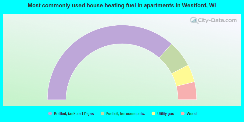
- 73.1%Bottled, tank, or LP gas
- 11.5%Fuel oil, kerosene, etc.
- 7.7%Utility gas
- 7.7%Wood
Westford compared to Wisconsin state average:
- Unemployed percentage significantly below state average.
- Black race population percentage significantly below state average.
- Hispanic race population percentage significantly below state average.
- Median age above state average.
- Foreign-born population percentage significantly below state average.
- Renting percentage significantly below state average.
- Length of stay since moving in significantly above state average.
- Number of rooms per house significantly below state average.
- House age significantly below state average.
- Number of college students below state average.
- Percentage of population with a bachelor's degree or higher significantly below state average.