West Texas, Oklahoma
Submit your own pictures of this place and show them to the world
- OSM Map
- General Map
- Google Map
- MSN Map

| Males: 926 | |
| Females: 830 |
| Median resident age: | 32.9 years |
| Oklahoma median age: | 35.5 years |
Zip code: 73939
| West Texas: | $54,114 |
| OK: | $59,673 |
Estimated per capita income in 2022: $23,850 (it was $16,022 in 2000)
West Texas CCD income, earnings, and wages data
Estimated median house or condo value in 2022: $149,678 (it was $56,000 in 2000)
| West Texas: | $149,678 |
| OK: | $191,700 |
Detailed information about poverty and poor residents in West Texas, OK


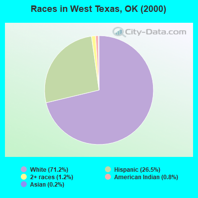
- 1,25471.2%White alone
- 46726.5%Hispanic
- 221.2%Two or more races
- 140.8%American Indian alone
- 30.2%Asian alone
- 10.06%Other race alone
Races in West Texas detailed stats: ancestries, foreign born residents, place of birth
 Recent articles from our blog. Our writers, many of them Ph.D. graduates or candidates, create easy-to-read articles on a wide variety of topics.
Current Local Time: CST time zone
Land area: 687.8 square miles.
Population density: 2.6 people per square mile (very low).
| West Texas CCD: | 0.5% ($285) |
| Oklahoma: | 0.8% ($523) |
Nearest city with pop. 50,000+: Amarillo, TX  (106.5 miles , pop. 173,627).
Nearest city with pop. 200,000+: Colorado Springs, CO (219.5 miles , pop. 360,890).
Nearest city with pop. 1,000,000+: Dallas, TX (394.3 miles , pop. 1,188,580).
Nearest cities:
), ), ), ), ), Latitude: 36.74 N, Longitude: 101.81 W
Area code commonly used in this area: 580


| Here: | 1.9% |
| Oklahoma: | 3.2% |
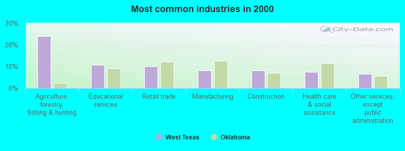
- Agriculture, forestry, fishing & hunting (24.0%)
- Educational services (10.6%)
- Construction (8.0%)
- Food (6.8%)
- Health care (6.1%)
- Accommodation & food services (4.4%)
- Finance & insurance (3.0%)
- Agriculture, forestry, fishing & hunting (34.1%)
- Construction (13.1%)
- Food (7.3%)
- Educational services (3.9%)
- Mining, quarrying, oil & gas extraction (3.2%)
- Repair & maintenance (3.2%)
- Professional, scientific, technical services (3.0%)
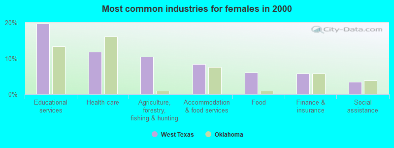
- Educational services (19.7%)
- Health care (11.9%)
- Agriculture, forestry, fishing & hunting (10.4%)
- Accommodation & food services (8.4%)
- Food (6.1%)
- Finance & insurance (5.8%)
- Social assistance (3.5%)
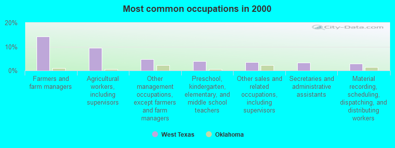
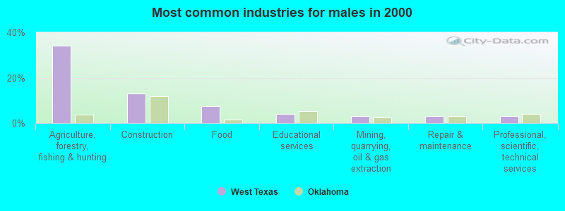
- Farmers and farm managers (14.2%)
- Agricultural workers, including supervisors (9.4%)
- Other management occupations, except farmers and farm managers (4.8%)
- Preschool, kindergarten, elementary, and middle school teachers (3.8%)
- Other sales and related occupations, including supervisors (3.6%)
- Secretaries and administrative assistants (3.3%)
- Material recording, scheduling, dispatching, and distributing workers (2.8%)
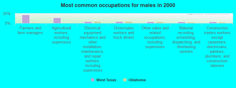
- Farmers and farm managers (21.3%)
- Agricultural workers, including supervisors (13.6%)
- Electrical equipment mechanics and other installation, maintenance, and repair workers, including supervisors (4.3%)
- Driver/sales workers and truck drivers (4.1%)
- Other sales and related occupations, including supervisors (3.9%)
- Material recording, scheduling, dispatching, and distributing workers (3.4%)
- Construction traders workers except carpenters, electricians, painters, plumbers, and construction laborers (3.4%)
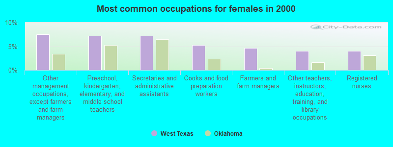
- Other management occupations, except farmers and farm managers (7.5%)
- Preschool, kindergarten, elementary, and middle school teachers (7.2%)
- Secretaries and administrative assistants (7.2%)
- Cooks and food preparation workers (5.2%)
- Farmers and farm managers (4.6%)
- Other teachers, instructors, education, training, and library occupations (4.1%)
- Registered nurses (4.1%)
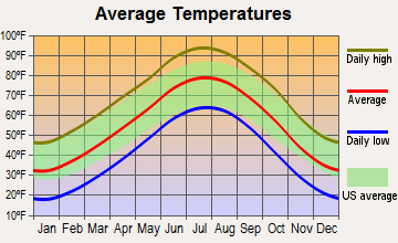
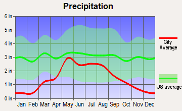
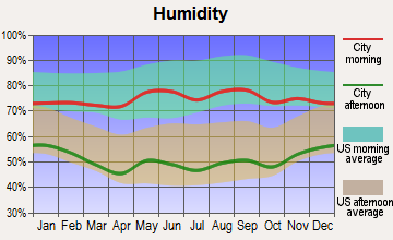
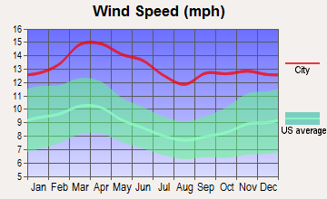
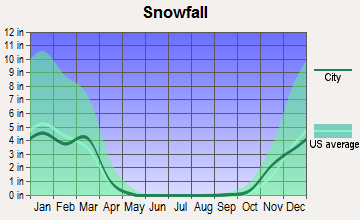
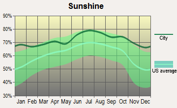
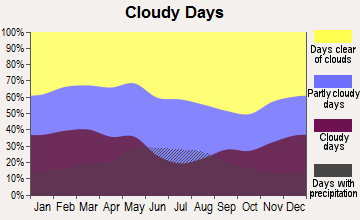
Average climate in West Texas, Oklahoma
Based on data reported by over 4,000 weather stations
Tornado activity:
West Texas-area historical tornado activity is significantly below Oklahoma state average. It is 8% greater than the overall U.S. average.
On 5/18/1977, a category F4 (max. wind speeds 207-260 mph) tornado 30.7 miles away from the West Texas place center caused between $500,000 and $5,000,000 in damages.
On 6/9/1971, a category F4 tornado 39.5 miles away from the place center .
Earthquake activity:
West Texas-area historical earthquake activity is significantly above Oklahoma state average. It is 645% greater than the overall U.S. average.On 8/23/2011 at 05:46:18, a magnitude 5.3 (5.3 MW, Depth: 2.5 mi, Class: Moderate, Intensity: VI - VII) earthquake occurred 161.6 miles away from the city center
On 9/3/2016 at 12:02:44, a magnitude 5.8 (5.8 MW, Depth: 3.5 mi) earthquake occurred 271.8 miles away from West Texas center
On 2/15/1974 at 13:33:49, a magnitude 4.6 (4.5 MB, 4.6 LG, Class: Light, Intensity: IV - V) earthquake occurred 64.1 miles away from the city center
On 2/13/2016 at 17:07:06, a magnitude 5.1 (5.1 MW, Depth: 5.2 mi) earthquake occurred 172.9 miles away from the city center
On 11/6/2011 at 03:53:10, a magnitude 5.7 (5.7 MW, Depth: 3.2 mi) earthquake occurred 293.8 miles away from West Texas center
On 8/10/2005 at 22:08:22, a magnitude 5.0 (5.0 MB, 4.7 MS, 5.0 MW) earthquake occurred 164.4 miles away from West Texas center
Magnitude types: regional Lg-wave magnitude (LG), body-wave magnitude (MB), surface-wave magnitude (MS), moment magnitude (MW)
Natural disasters:
The number of natural disasters in Texas County (15) is near the US average (15).Major Disasters (Presidential) Declared: 6
Emergencies Declared: 5
Causes of natural disasters: Winter Storms: 7, Storms: 4, Floods: 3, Tornadoes: 3, Fire: 1, Hurricane: 1, Ice Storm: 1, Wind: 1, Other: 1 (Note: some incidents may be assigned to more than one category).
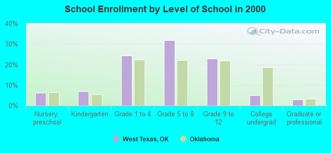
Colleges/universities with over 2000 students nearest to West Texas:
- Amarillo College (about 108 miles; Amarillo, TX; Full-time enrollment: 6,622)
- West Texas A & M University (about 122 miles; Canyon, TX; FT enrollment: 6,820)
- Wayland Baptist University (about 177 miles; Plainview, TX; FT enrollment: 5,526)
- Colorado State University-Pueblo (about 187 miles; Pueblo, CO; FT enrollment: 5,993)
- Pueblo Community College (about 188 miles; Pueblo, CO; FT enrollment: 5,329)
- Southwestern Oklahoma State University (about 193 miles; Weatherford, OK; FT enrollment: 4,126)
- Eastern New Mexico University-Main Campus (about 198 miles; Portales, NM; FT enrollment: 4,263)
Points of interest:
Notable locations in West Texas: Four Corners (A), Texhoma Volunteer Ambulance Service (B), Texhoma Volunteer Fire Department (C), Yarbrough Fire Department (D). Display/hide their locations on the map
Cemeteries: Baker Cemetery (1), Bethel Cemetery (2), Cosmos Cemetery (3), Kuhn Cemetery (4). Display/hide their locations on the map
Reservoir: Etling Number 2 Reservoir (A). Display/hide its location on the map
Creeks: Tepee Creek (A), Spring Aroa Creek (B), Sand Creek (C). Display/hide their locations on the map
| This place: | 2.8 people |
| Oklahoma: | 2.5 people |
| This place: | 77.7% |
| Whole state: | 66.8% |
| This place: | 5.5% |
| Whole state: | 5.9% |
Likely homosexual households (counted as self-reported same-sex unmarried-partner households)
- Lesbian couples: 0.2% of all households
- Gay men: 0.0% of all households
| This place: | 13.1% |
| Whole state: | 14.7% |
| This place: | 3.9% |
| Whole state: | 6.1% |
For population 15 years and over in West Texas:
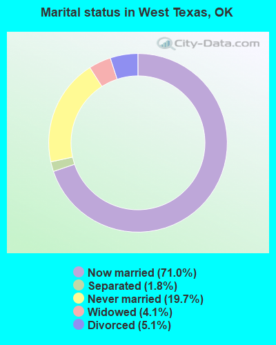
- Never married: 19.7%
- Now married: 71.0%
- Separated: 1.8%
- Widowed: 4.1%
- Divorced: 5.1%
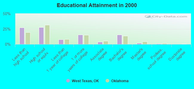
For population 25 years and over in West Texas:
- High school or higher: 73.0%
- Bachelor's degree or higher: 18.4%
- Graduate or professional degree: 3.0%
- Unemployed: 3.8%
- Mean travel time to work (commute): 20.1 minutes
| Here: | 15.1 |
| Oklahoma average: | 11.7 |
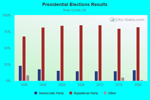
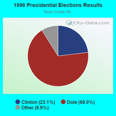
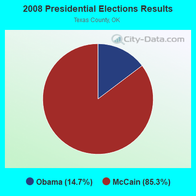
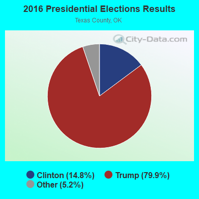
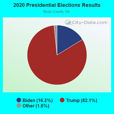
Graphs represent county-level data. Detailed 2008 Election Results
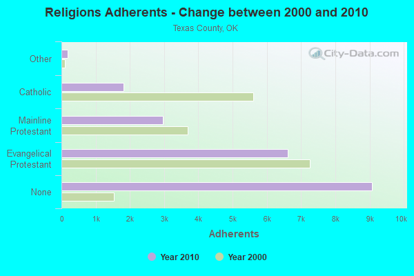
Religion statistics for West Texas, OK (based on Texas County data)
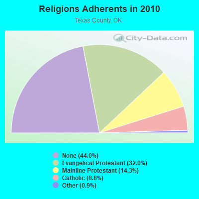
| Religion | Adherents | Congregations |
|---|---|---|
| Evangelical Protestant | 6,603 | 47 |
| Mainline Protestant | 2,956 | 12 |
| Catholic | 1,814 | 2 |
| Other | 189 | 2 |
| None | 9,078 | - |
Food Environment Statistics:
| Texas County: | 3.02 / 10,000 pop. |
| State: | 1.97 / 10,000 pop. |
| Here: | 1.01 / 10,000 pop. |
| State: | 0.76 / 10,000 pop. |
| Texas County: | 4.52 / 10,000 pop. |
| Oklahoma: | 4.35 / 10,000 pop. |
| This county: | 9.05 / 10,000 pop. |
| State: | 6.89 / 10,000 pop. |
| Here: | 8.0% |
| State: | 10.3% |
| Texas County: | 30.9% |
| Oklahoma: | 29.2% |
Strongest AM radio stations in West Texas:
- KGYN (1210 AM; 50 kW; GUYMON, OK; Owner: TELNS BROADCASTING COMPANY, INC.)
- KGNC (710 AM; 10 kW; AMARILLO, TX; Owner: MCC RADIO, LLC)
- KICA (980 AM; 50 kW; CLOVIS, NM; Owner: BROADCAST ENTERTAINMENT CORPORATION)
- KSCB (1270 AM; 5 kW; LIBERAL, KS; Owner: SEWARD COUNTY BROADCASTING CO., INC.)
- KMUL (1380 AM; 50 kW; MULESHOE, TX; Owner: BROADCAST ENTERTAINMENT CORPORATION)
- KKOB (770 AM; 50 kW; ALBUQUERQUE, NM; Owner: CITADEL BROADCASTING COMPANY)
- KLTT (670 AM; 50 kW; COMMERCE CITY, CO; Owner: KLZ RADIO, INC.)
- KOA (850 AM; 50 kW; DENVER, CO; Owner: JACOR BROADCASTING OF COLORADO, INC.)
- KKZN (760 AM; 50 kW; THORNTON, CO; Owner: JACOR BROADCASTING OF COLORADO, INC.)
- KMXA (1090 AM; 50 kW; AURORA, CO; Owner: ENTRAVISION HOLDINGS, LLC)
- KRMG (740 AM; 50 kW; TULSA, OK; Owner: CXR HOLDINGS, INC.)
- KINF (1020 AM; 50 kW; ROSWELL, NM; Owner: JAMES CRYSTAL HOLDINGS OF NEW MEXICO, INC.)
- KRVN (880 AM; 50 kW; LEXINGTON, NE; Owner: NEBRASKA RURAL RADIO ASSOCIATION)
Strongest FM radio stations in West Texas:
- K215CV (90.9 FM; GUYMON, OK; Owner: LIFE ON THE WAY COMMUNICATIONS, INC.)
- KKBS (92.7 FM; GUYMON, OK; Owner: MLS COMMUNICATIONS, INC.)
- K211CB (90.1 FM; GUYMON, OK; Owner: GUYMON OKLAHOMA TRANSLATOR COMMITTEE)
- KPSU (91.7 FM; GOODWELL, OK; Owner: PANHANDLE STATE UNIVERSITY)
TV broadcast stations around West Texas:
- K28GI (Channel 63; GUYMON, OK; Owner: GUYMON TV TRANSLATOR, INC.)
- K57HY (Channel 57; GUYMON, OK; Owner: GUYMON TV TRANSLATOR, INC.)
- K30FY (Channel 30; GUYMON, OK; Owner: GUYMON TV TRANSLATOR, INC.)
- K59GF (Channel 59; GUYMON, ETC., OK; Owner: GUYMON TV TRANSLATOR, INC.)
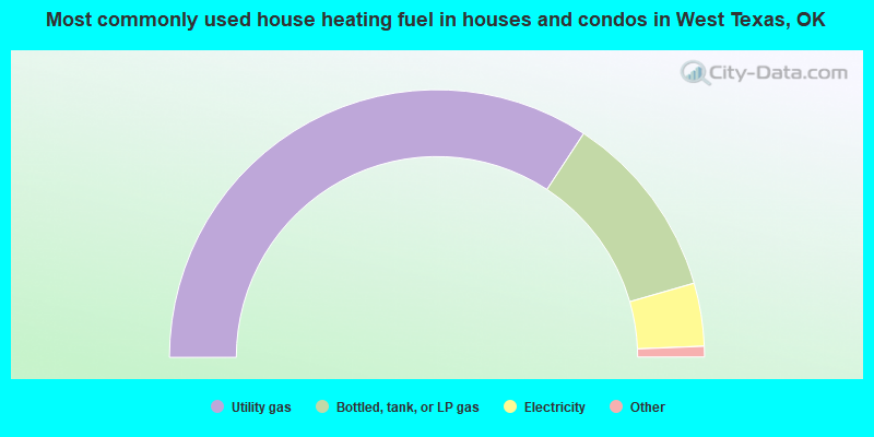
- 68.5%Utility gas
- 22.6%Bottled, tank, or LP gas
- 7.6%Electricity
- 0.9%Wood
- 0.4%No fuel used
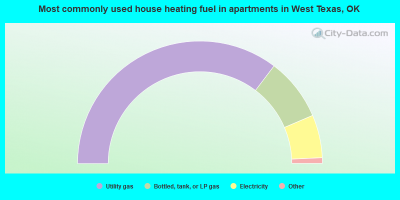
- 70.6%Utility gas
- 16.5%Bottled, tank, or LP gas
- 11.3%Electricity
- 1.0%Other fuel
- 0.5%Wood
West Texas compared to Oklahoma state average:
- Unemployed percentage significantly below state average.
- Black race population percentage significantly below state average.
- Hispanic race population percentage above state average.
- Median age below state average.
- Foreign-born population percentage significantly below state average.
- Length of stay since moving in significantly above state average.
- Number of rooms per house significantly below state average.
- House age significantly below state average.
- Number of college students below state average.