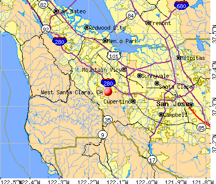
West Santa Clara, California
Submit your own pictures of this place and show them to the world
- OSM Map
- General Map
- Google Map
- MSN Map
| Males: 4,066 | |
| Females: 4,252 |
| Median resident age: | 47.3 years |
| California median age: | 33.3 years |
Zip code: 94022
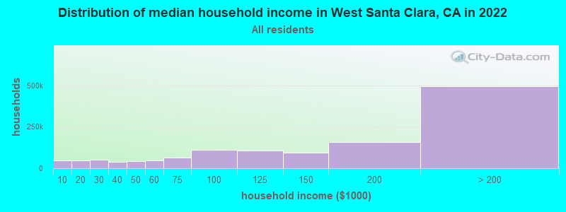
| West Santa Clara: | over $200,000 |
| CA: | $91,551 |
Estimated per capita income in 2022: $200,001 (it was $87,310 in 2000)
West Santa Clara CCD income, earnings, and wages data
Estimated median house or condo value in 2022: over $1,000,000 (it was over $1,000,000 in 2000)
| West Santa Clara: | over $1,000,000 |
| CA: | $715,900 |
Mean prices in 2022: all housing units: over $1,000,000; detached houses: over $1,000,000; townhouses or other attached units: over $1,000,000; in 2-unit structures: over $1,000,000; in 3-to-4-unit structures: $934,406; in 5-or-more-unit structures: $849,080; mobile homes: $230,447; occupied boats, rvs, vans, etc.: $68,106
West Santa Clara, CA residents, houses, and apartments details
Detailed information about poverty and poor residents in West Santa Clara, CA


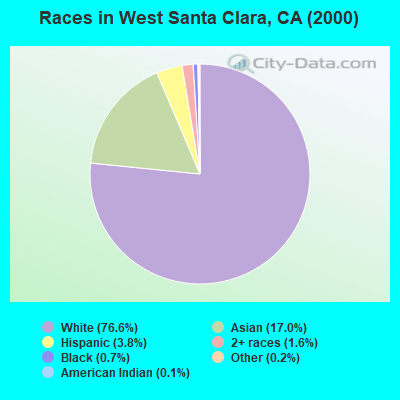
- 6,23076.6%White alone
- 1,38017.0%Asian alone
- 3083.8%Hispanic
- 1301.6%Two or more races
- 540.7%Black alone
- 140.2%Other race alone
- 120.1%American Indian alone
- 70.09%Native Hawaiian and Other
Pacific Islander alone
 Recent articles from our blog. Our writers, many of them Ph.D. graduates or candidates, create easy-to-read articles on a wide variety of topics.
Current Local Time: PST time zone
Land area: 54.2 square miles.
Population density: 153 people per square mile (very low).

| West Santa Clara CCD: | 0.7% ($6,514) |
| California: | 0.8% ($1,564) |
Nearest city with pop. 50,000+: Mountain View, CA  (4.6 miles , pop. 70,708).
Nearest city with pop. 200,000+: San Jose, CA (14.6 miles , pop. 894,943).
Nearest city with pop. 1,000,000+: Los Angeles, CA (308.5 miles , pop. 3,694,820).
Nearest cities:
), ), Latitude: 37.34 N, Longitude: 122.13 W
Area code commonly used in this area: 650

| Here: | 3.9% |
| California: | 5.1% |
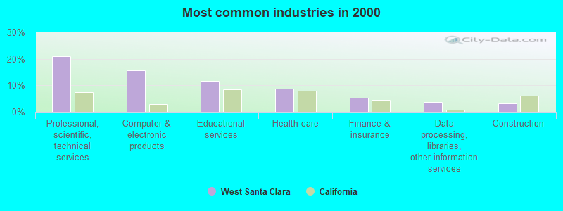
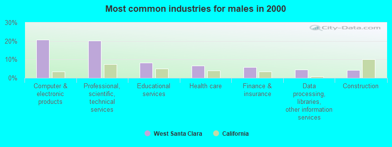
- Professional, scientific, technical services (20.8%)
- Computer & electronic products (15.7%)
- Educational services (11.8%)
- Health care (8.8%)
- Finance & insurance (5.2%)
- Data processing, libraries, other information services (3.6%)
- Construction (3.1%)
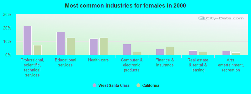
- Computer & electronic products (20.8%)
- Professional, scientific, technical services (20.3%)
- Educational services (8.2%)
- Health care (6.6%)
- Finance & insurance (5.8%)
- Data processing, libraries, other information services (4.6%)
- Construction (4.2%)
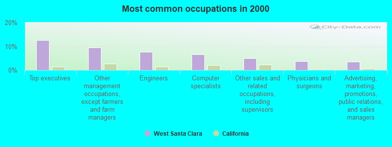
- Professional, scientific, technical services (21.7%)
- Educational services (17.1%)
- Health care (12.1%)
- Computer & electronic products (8.1%)
- Finance & insurance (4.3%)
- Real estate & rental & leasing (3.2%)
- Arts, entertainment, recreation (3.1%)
- Top executives (12.5%)
- Other management occupations, except farmers and farm managers (9.5%)
- Engineers (7.6%)
- Computer specialists (6.7%)
- Other sales and related occupations, including supervisors (4.9%)
- Physicians and surgeons (3.7%)
- Advertising, marketing, promotions, public relations, and sales managers (3.6%)
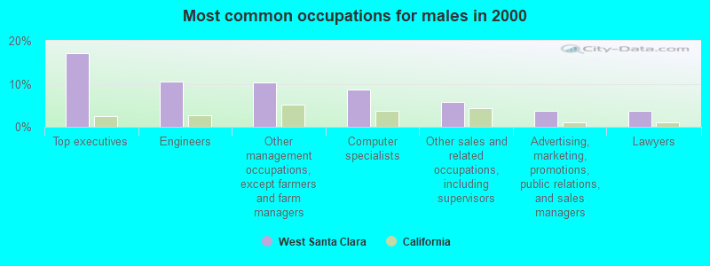
- Top executives (17.0%)
- Engineers (10.5%)
- Other management occupations, except farmers and farm managers (10.2%)
- Computer specialists (8.6%)
- Other sales and related occupations, including supervisors (5.7%)
- Advertising, marketing, promotions, public relations, and sales managers (3.7%)
- Lawyers (3.7%)
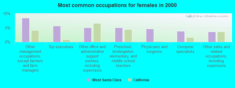
- Other management occupations, except farmers and farm managers (8.4%)
- Top executives (5.7%)
- Other office and administrative support workers, including supervisors (5.0%)
- Preschool, kindergarten, elementary, and middle school teachers (5.0%)
- Physicians and surgeons (4.7%)
- Computer specialists (3.8%)
- Other sales and related occupations, including supervisors (3.6%)
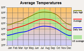
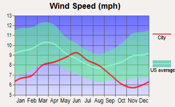
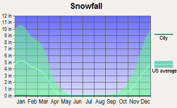
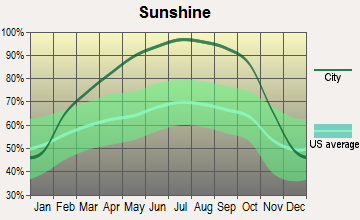
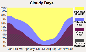
Average climate in West Santa Clara, California
Based on data reported by over 4,000 weather stations
(lower is better)
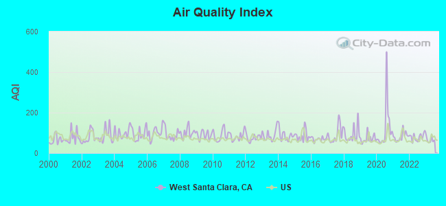
Air Quality Index (AQI) level in 2023 was 65.4. This is about average.
| City: | 65.4 |
| U.S.: | 72.6 |
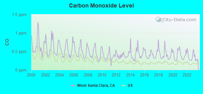
Carbon Monoxide (CO) [ppm] level in 2023 was 0.300. This is about average. Closest monitor was 3.8 miles away from the city center.
| City: | 0.300 |
| U.S.: | 0.251 |
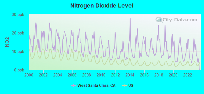
Nitrogen Dioxide (NO2) [ppb] level in 2023 was 7.87. This is significantly worse than average. Closest monitor was 3.8 miles away from the city center.
| City: | 7.87 |
| U.S.: | 5.11 |
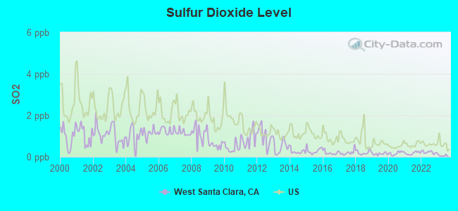
Sulfur Dioxide (SO2) [ppb] level in 2023 was 0.0660. This is significantly better than average. Closest monitor was 3.8 miles away from the city center.
| City: | 0.0660 |
| U.S.: | 1.5147 |
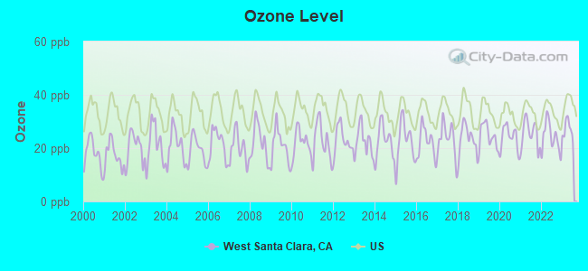
Ozone [ppb] level in 2023 was 27.0. This is better than average. Closest monitor was 3.8 miles away from the city center.
| City: | 27.0 |
| U.S.: | 33.3 |
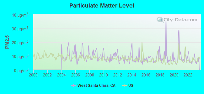
Particulate Matter (PM2.5) [µg/m3] level in 2023 was 6.20. This is better than average. Closest monitor was 10.6 miles away from the city center.
| City: | 6.20 |
| U.S.: | 8.11 |
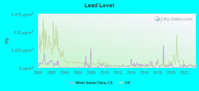
Lead (Pb) [µg/m3] level in 2023 was 0.00228. This is significantly better than average. Closest monitor was 3.8 miles away from the city center.
| City: | 0.00228 |
| U.S.: | 0.00931 |
Earthquake activity:
West Santa Clara-area historical earthquake activity is significantly above California state average. It is 7481% greater than the overall U.S. average.On 4/18/1906 at 13:12:21, a magnitude 7.9 (7.9 UK, Class: Major, Intensity: VIII - XII) earthquake occurred 65.8 miles away from the city center, causing $524,000,000 total damage
On 10/18/1989 at 00:04:15, a magnitude 7.1 (6.5 MB, 7.1 MS, 6.9 MW, 7.0 ML) earthquake occurred 25.6 miles away from the city center, causing 62 deaths (62 shaking deaths) and 3757 injuries, causing $1,305,032,704 total damage
On 11/4/1927 at 13:51:53, a magnitude 7.5 (7.5 UK) earthquake occurred 178.7 miles away from the city center
On 7/21/1952 at 11:52:14, a magnitude 7.7 (7.7 UK) earthquake occurred 238.3 miles away from West Santa Clara center, causing $50,000,000 total damage
On 1/31/1922 at 13:17:28, a magnitude 7.6 (7.6 UK) earthquake occurred 296.2 miles away from the city center
On 4/25/1992 at 18:06:04, a magnitude 7.2 (6.3 MB, 7.1 MS, 7.2 MW, 7.1 MW, Depth: 9.4 mi) earthquake occurred 232.8 miles away from the city center, causing $75,000,000 total damage
Magnitude types: body-wave magnitude (MB), local magnitude (ML), surface-wave magnitude (MS), moment magnitude (MW)
Natural disasters:
The number of natural disasters in Santa Clara County (19) is greater than the US average (15).Major Disasters (Presidential) Declared: 10
Emergencies Declared: 3
Causes of natural disasters: Floods: 9, Fires: 5, Winter Storms: 5, Storms: 4, Mudslides: 3, Landslides: 2, Drought: 1, Earthquake: 1, Freeze: 1, Hurricane: 1, Tornado: 1, Other: 1 (Note: some incidents may be assigned to more than one category).
Hospitals and medical centers near West Santa Clara:
- LOS ALTOS SUB-ACUTE AND REHABILITATION CENTER (Nursing Home, about 3 miles away; LOS ALTOS, CA)
- HEALTH CARE CTR AT THE FORUM AT RANCHO SAN ANTONIO (Nursing Home, about 3 miles away; CUPERTINO, CA)
- STANFORD HOME CARE (Home Health Center, about 3 miles away; PALO ALTO, CA)
- VILLA SIENA (Nursing Home, about 4 miles away; MOUNTAIN VIEW, CA)
- MOUNTAIN VIEW HEALTHCARE CTR (Nursing Home, about 4 miles away; MOUNTAIN VIEW, CA)
- EL CAMINO HOSPITAL Acute Care Hospitals (about 4 miles away; MOUNTAIN VIEW, CA)
- EL CAMINO DIALYSIS CENTER (Dialysis Facility, about 4 miles away; MOUNTAIN VIEW, CA)
Amtrak stations near West Santa Clara:
- 11 miles: SANTA CLARA-GREAT AMERICA (SANTA CLARA, FOOT OF STARS & STRIPES DR.) . Services: partially wheelchair accessible, free short-term parking.
- 13 miles: SAN JOSE (65 CAHILL ST.) . Services: ticket office, fully wheelchair accessible, enclosed waiting area, public restrooms, public payphones, paid short-term parking, free long-term parking, taxi stand, public transit connection.
- 17 miles: FREMONT (CENTERVILLE, FREMONT & PERALTA BLVDS.) . Services: fully wheelchair accessible, enclosed waiting area, public restrooms, public payphones, snack bar, free short-term parking, free long-term parking, call for car rental service, call for taxi service, public transit connection.
Colleges/universities with over 2000 students nearest to West Santa Clara:
- Foothill College (about 2 miles; Los Altos Hills, CA; Full-time enrollment: 9,635)
- De Anza College (about 6 miles; Cupertino, CA; FT enrollment: 16,729)
- Stanford University (about 7 miles; Stanford, CA; FT enrollment: 14,410)
- West Valley College (about 9 miles; Saratoga, CA; FT enrollment: 6,128)
- Mission College (about 10 miles; Santa Clara, CA; FT enrollment: 5,625)
- Canada College (about 11 miles; Redwood City, CA; FT enrollment: 3,446)
- Santa Clara University (about 11 miles; Santa Clara, CA; FT enrollment: 7,640)
Points of interest:
Notable locations in West Santa Clara: Camp Cooley (A), Camp Saratoga (B), Stuart Camp (C), Skyline Ranch (D), Shotgun Bend (E), Congress Springs Vineyards (F), Sunrise Winery (G), Foothills Park Nature Interpretive Center (H), Stanford Industrial Park (I), Palo Alto Hills Golf and Country Club (J), National Bureau of Economic Research (K), Center for Advanced Study in the Behavioral Sciences (L), Department of Forestry and Fire Protection Station 23 Stevens Creek (M), Santa Clara County Fire Department El Monte Fire Station (N), Palo Alto Fire Department Ambulance Station 2 (O), Mount Helen Childrens Home (P). Display/hide their locations on the map
Shopping Center: Palo Alto Square Shopping Center (1). Display/hide its location on the map
Cemetery: Gates of Heaven Cemetery (1). Display/hide its location on the map
Reservoirs: Lake Ranch Reservoir (A), Borondo Lake (B), Lake McKenzie (C), Felt Lake (D). Display/hide their locations on the map
Creeks: Bonjetti Creek (A), Booker Creek (B), Gold Mine Creek (C), Indian Cabin Creek (D), Indian Creek (E), McElroy Creek (F), West Fork Adobe Creek (G), Todd Creek (H), Los Trancos Creek (I). Display/hide their locations on the map
Parks in West Santa Clara include: Stevens Creek Park (1), Foothills Park (2), Arastradero Preserve (3), Bol Park (4), Foothills Open Space Preserve (5), Los Trancas Open Space Preserve (6), Monte Bello Open Space Preserve (7), Picchetti Ranch Area Monte Bello Open Space Preserve (8), Rancho San Antonio County Park (9). Display/hide their locations on the map
| This place: | 2.6 people |
| California: | 2.9 people |
| This place: | 74.0% |
| Whole state: | 68.7% |
| This place: | 3.3% |
| Whole state: | 7.2% |
Likely homosexual households (counted as self-reported same-sex unmarried-partner households)
- Lesbian couples: 0.3% of all households
- Gay men: 0.4% of all households
| This place: | 4.5% |
| Whole state: | 14.2% |
| This place: | 1.2% |
| Whole state: | 6.3% |
People in group quarters in West Santa Clara in 2010:
- 83 people in other noninstitutional facilities
- 39 people in nursing facilities/skilled-nursing facilities
- 10 people in college/university student housing
- 10 people in workers' group living quarters and job corps centers
People in group quarters in West Santa Clara in 2000:
- 82 people in religious group quarters
- 77 people in nursing homes
- 47 people in orthopedic wards and institutions for the physically handicapped
- 23 people in institutions for the blind
- 20 people in wards in general hospitals for patients who have no usual home elsewhere
- 20 people in other nonhousehold living situations
- 15 people in agriculture workers' dormitories on farms
For population 15 years and over in West Santa Clara:
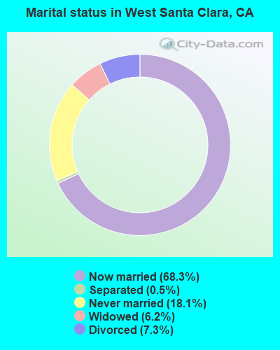
- Never married: 18.1%
- Now married: 68.3%
- Separated: 0.5%
- Widowed: 6.2%
- Divorced: 7.3%
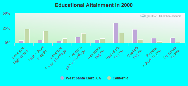
For population 25 years and over in West Santa Clara:
- High school or higher: 95.9%
- Bachelor's degree or higher: 73.4%
- Graduate or professional degree: 39.4%
- Unemployed: 3.0%
- Mean travel time to work (commute): 22.4 minutes
| Here: | 10.0 |
| California average: | 16.1 |
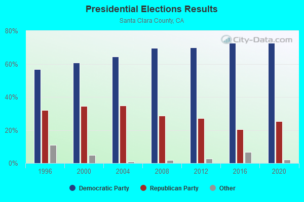
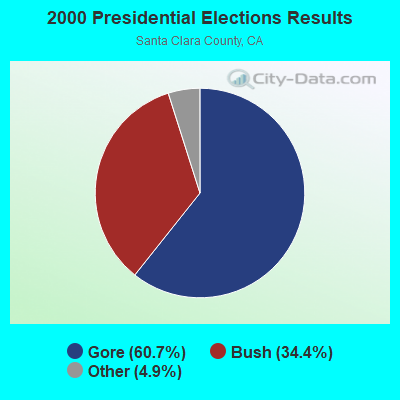
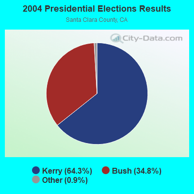
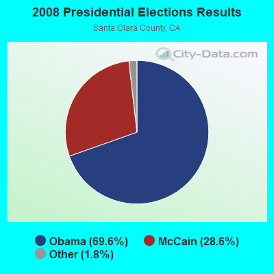
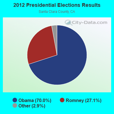
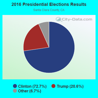
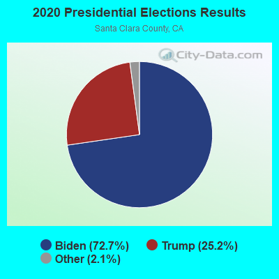
Graphs represent county-level data. Detailed 2008 Election Results
Religion statistics for West Santa Clara, CA (based on Santa Clara County data)
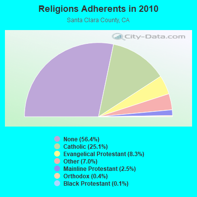
| Religion | Adherents | Congregations |
|---|---|---|
| Catholic | 447,369 | 56 |
| Evangelical Protestant | 148,599 | 481 |
| Other | 125,165 | 221 |
| Mainline Protestant | 44,623 | 132 |
| Orthodox | 7,720 | 17 |
| Black Protestant | 2,552 | 20 |
| None | 1,005,614 | - |
Food Environment Statistics:
| Santa Clara County: | 1.99 / 10,000 pop. |
| California: | 2.14 / 10,000 pop. |
| This county: | 0.04 / 10,000 pop. |
| State: | 0.04 / 10,000 pop. |
| Santa Clara County: | 0.68 / 10,000 pop. |
| California: | 0.62 / 10,000 pop. |
| This county: | 1.38 / 10,000 pop. |
| State: | 1.49 / 10,000 pop. |
| Santa Clara County: | 8.59 / 10,000 pop. |
| State: | 7.42 / 10,000 pop. |
| Santa Clara County: | 7.1% |
| State: | 7.3% |
| Here: | 19.0% |
| California: | 21.3% |
| This county: | 16.6% |
| California: | 17.9% |
5.37% of this county's 2021 resident taxpayers lived in other counties in 2020 ($152,550 average adjusted gross income)
| Here: | 5.37% |
| California average: | 5.19% |
0.01% of residents moved from foreign countries ($93 average AGI)
Santa Clara County: 0.01% California average: 0.03%
Top counties from which taxpayers relocated into this county between 2020 and 2021:
| from Alameda County, CA | |
| from San Mateo County, CA | |
| from San Francisco County, CA |
7.70% of this county's 2020 resident taxpayers moved to other counties in 2021 ($201,706 average adjusted gross income)
| Here: | 7.70% |
| California average: | 6.14% |
0.01% of residents moved to foreign countries ($110 average AGI)
Santa Clara County: 0.01% California average: 0.02%
Top counties to which taxpayers relocated from this county between 2020 and 2021:
| to Alameda County, CA | |
| to San Mateo County, CA | |
| to San Francisco County, CA |
Strongest AM radio stations in West Santa Clara:
- KGO (810 AM; 50 kW; SAN FRANCISCO, CA; Owner: KGO-AM RADIO, INC.)
- KNBR (680 AM; 50 kW; SAN FRANCISCO, CA; Owner: KNBR LICO, INC.)
- KYCY (1550 AM; 50 kW; SAN FRANCISCO, CA; Owner: INFINITY BROADCASTING OPERATIONS, INC.)
- KLOK (1170 AM; 50 kW; SAN JOSE, CA; Owner: ENTRAVISION HOLDINGS, LLC)
- KTCT (1050 AM; 50 kW; SAN MATEO, CA; Owner: SUSQUEHANNA RADIO CORP.)
- KFAX (1100 AM; 50 kW; SAN FRANCISCO, CA; Owner: GOLDEN GATE BROADCASTING CO, INC.)
- KTRB (860 AM; 50 kW; MODESTO, CA; Owner: PAPPAS RADIO OF CALIFORNIA, A CALIFORNIA LIMITED PARTNERSHIP)
- KSFB (1220 AM; 5 kW; PALO ALTO, CA; Owner: SCA-PALO ALTO, LLC)
- KSJX (1500 AM; 10 kW; SAN JOSE, CA; Owner: MULTICULTURAL RADIO BROADCASTING INC)
- KIQI (1010 AM; 35 kW; SAN FRANCISCO, CA; Owner: RADIO UNICA OF SAN FRANCISCO LICENSE CORP.)
- KCBS (740 AM; 50 kW; SAN FRANCISCO, CA; Owner: INFINITY BROADCASTING OPERATIONS, INC.)
- KZSF (1370 AM; 5 kW; SAN JOSE, CA; Owner: CARLOS A. DUHARTE)
- KLIV (1590 AM; 5 kW; SAN JOSE, CA; Owner: EMPIRE BROADCASTING COMPANY)
Strongest FM radio stations in West Santa Clara:
- KFJC (89.7 FM; LOS ALTOS, CA; Owner: FOOTHILL-DE ANZA COMM. COLLEGE DIST.)
- KFFG (97.7 FM; LOS ALTOS, CA; Owner: KFFG LICO, INC.)
- KBAA (94.5 FM; GILROY, CA; Owner: INFINITY RADIO OPERATIONS INC.)
- KSQL (99.1 FM; SANTA CRUZ, CA; Owner: TMS LICENSE CALIFORNIA, INC)
- KKUP (91.5 FM; CUPERTINO, CA; Owner: ASSURANCE SCIENCES FOUNDATION)
- KBRG (100.3 FM; SAN JOSE, CA; Owner: ENTRAVISION HOLDINGS, LLC)
- KTEE (93.7 FM; FELTON, CA; Owner: MAPLETON COMMUNICATIONS, L.L.C.)
- KUFX (98.5 FM; SAN JOSE, CA; Owner: CITICASTERS LICENSES, L.P.)
- KRTY (95.3 FM; LOS GATOS, CA; Owner: KRTY, LTD.)
- KZBR-FM2 (95.7 FM; LIVERMORE, ETC., CA; Owner: BONNEVILLE HOLDING COMPANY)
- KKSF-FM1 (103.7 FM; PLEASANTON, ETC., CA; Owner: AMFM RADIO LICENSES, L.L.C.)
- KFRC-FM3 (99.7 FM; WALNUT CREEK, CA; Owner: INFINITY KFRC-FM, INC.)
- KZBR-FM1 (95.7 FM; WALNUT CREEK, CA; Owner: BONNEVILLE HOLDING COMPANY)
- KBLX-FM2 (102.9 FM; PLEASANTON, CA; Owner: ICBC BROADCAST HOLDINGS -CA, INC.)
- KSOL-FM3 (98.9 FM; PLEASANTON, CA; Owner: TMS LICENSE CALIFORNIA, INC)
- KISQ-FM3 (98.1 FM; CONCORD, CA; Owner: AMFM RADIO LICENSES, L.L.C.)
- KMEL-FM1 (106.1 FM; CONCORD, CA; Owner: AMFM RADIO LICENSES, L.L.C.)
- K216AX (91.1 FM; LAUREL, CA; Owner: CALVARY CHAPEL OF TWIN FALLS, INC.)
- K238AC (95.5 FM; SALIDA, CA; Owner: FAMILY STATIONS, INC.)
- KYLD (94.9 FM; SAN FRANCISCO, CA; Owner: AMFM RADIO LICENSES, L.L.C.)
TV broadcast stations around West Santa Clara:
- KQED (Channel 9; SAN FRANCISCO, CA; Owner: KQED, INC.)
- KBIT-CA (Channel 28; SAN FRANCISCO, ETC., CA; Owner: POLAR BROADCASTING, INC.)
- KICU-TV (Channel 36; SAN JOSE, CA; Owner: KTVU PARTNERSHIP)
- KGO-TV (Channel 7; SAN FRANCISCO, CA; Owner: KGO TELEVISION, INC.)
- KPIX-TV (Channel 5; SAN FRANCISCO, CA; Owner: CBS BROADCASTING INC.)
- KTEH (Channel 54; SAN JOSE, CA; Owner: KTEH FOUNDATION)
- KTVU (Channel 2; OAKLAND, CA; Owner: KTVU PARTNERSHIP)
- KDTV (Channel 14; SAN FRANCISCO, CA; Owner: KDTV LICENSE PARTNERSHIP, G.P.)
- KSTS (Channel 48; SAN JOSE, CA; Owner: TELEMUNDO OF NORTHERN CALIFORNIA LICENSE CORP.)
- KRON-TV (Channel 4; SAN FRANCISCO, CA; Owner: YOUNG BROADCASTING OF SAN FRANCISCO, INC.)
- KMTP-TV (Channel 32; SAN FRANCISCO, CA; Owner: MINORITY TELEVISION PROJECT)
- KBHK-TV (Channel 44; SAN FRANCISCO, CA; Owner: VIACOM TELEVISION STATIONS GROUP OF SAN FRANCISCO INC.)
- KBWB (Channel 20; SAN FRANCISCO, CA; Owner: KBWB LICENSE, INC.)
- KCSM-TV (Channel 60; SAN MATEO, CA; Owner: SAN MATEO COUNTY COMMUNITY COLLEGE DISTRICT)
- KFSF (Channel 66; VALLEJO, CA; Owner: TELEFUTURA SAN FRANCISCO LLC)
- KCNS (Channel 38; SAN FRANCISCO, CA; Owner: WRAY, INC.)
- KNTV (Channel 11; SAN JOSE, CA; Owner: KNTV LICENSE, INC.)
- KKPX (Channel 65; SAN JOSE, CA; Owner: PAXSON SAN JOSE LICENSE, INC.)
- 74.7%Utility gas
- 14.5%Electricity
- 7.7%Bottled, tank, or LP gas
- 1.3%Wood
- 1.3%Fuel oil, kerosene, etc.
- 0.6%No fuel used
- 39.0%Utility gas
- 30.9%Electricity
- 22.3%Bottled, tank, or LP gas
- 5.0%Wood
- 1.8%Fuel oil, kerosene, etc.
- 1.1%Other fuel
West Santa Clara compared to California state average:
- Median household income above state average.
- Unemployed percentage significantly below state average.
- Black race population percentage significantly below state average.
- Hispanic race population percentage significantly below state average.
- Median age significantly above state average.
- Foreign-born population percentage significantly below state average.
- Renting percentage significantly below state average.
- Length of stay since moving in significantly above state average.
- Number of rooms per house significantly below state average.
- House age significantly below state average.
- Percentage of population with a bachelor's degree or higher significantly above state average.
West Santa Clara on our top lists:
- #1 on the list of "Top 101 cities with largest percentage of females in occupations: engineers (population 5,000+)"
- #1 on the list of "Top 101 cities with largest percentage of males in industries: data processing, libraries, and other information services (population 5,000+)"
- #1 on the list of "Top 101 cities with largest percentage of females in occupations: physicians and surgeons (population 5,000+)"
- #1 on the list of "Top 101 cities with largest percentage of females in occupations: top executives (population 5,000+)"
- #2 on the list of "Top 101 cities with largest percentage of males in occupations: top executives (population 5,000+)"
- #3 on the list of "Top 101 cities with largest percentage of males in industries: computer and electronic products (population 5,000+)"
- #6 on the list of "Top 101 cities with largest percentage of males in occupations: engineers (population 5,000+)"
- #9 on the list of "Top 101 cities with largest percentage of females in occupations: other management occupations except farmers and farm managers (population 5,000+)"
- #10 on the list of "Top 101 cities with the smallest house values disparities (population 5,000+)"
- #10 on the list of "Top 101 cities with the largest percentage of people in institutions for the blind (population 1,000+)"
- #11 on the list of "Top 101 cities with largest percentage of females in industries: computer and electronic products (population 5,000+)"
- #25 on the list of "Top 100 cities with highest median household income (pop. 5,000+)"
- #29 on the list of "Top 101 cities with largest percentage of females in industries: professional, scientific, and technical services (population 5,000+)"
- #37 on the list of "Top 101 cities with the largest percentage of people in orthopedic wards and institutions for the physically handicapped (population 1,000+)"
- #39 on the list of "Top 101 cities with largest percentage of females in industries: data processing, libraries, and other information services (population 5,000+)"
- #50 on the list of "Top 101 cities with the most cars per house, population 5,000+"
- #50 on the list of "Top 100 cities with highest median house value (pop. 5,000+)"
- #56 on the list of "Top 101 cities with the highest percentage of workers working at home, population 5,000+"
- #63 on the list of "Top 101 cities with the largest percentage of people in religious group quarters (population 1,000+)"
- #72 on the list of "Top 101 cities with largest percentage of males in industries: music stores (population 5,000+)"
- #3 (94022) on the list of "Top 101 zip codes with the largest percentage of taxpayers reporting taxable interest in 2012 (pop 5,000+)"
- #5 (94022) on the list of "Top 101 zip codes with the largest percentage of taxpayers reporting net capital gain/loss in 2012 (pop 5,000+)"
- #5 (94022) on the list of "Top 101 zip codes with the highest 2012 average reported profit/loss from business (pop 5,000+)"
- #11 (94022) on the list of "Top 101 zip codes with the highest average reported salary/wage in 2012 (pop 5,000+)"
- #17 (94022) on the list of "Top 101 zip codes with the highest 2012 average Adjusted Gross Income (AGI) for individuals (pop 5,000+)"
- #33 (94022) on the list of "Top 101 zip codes with the highest 2012 average net capital gain/loss (pop 5,000+)"
- #41 (94022) on the list of "Top 101 zip codes with the largest percentage of taxpayers using charity contributions deductions in 2012 (pop 5,000+)"
- #5 on the list of "Top 101 counties with the highest percentage of residents that visited a dentist within the past year"
- #9 on the list of "Top 101 counties with the lowest percentage of residents that smoked 100+ cigarettes in their lives"
- #16 on the list of "Top 101 counties with the most Other adherents"
- #16 on the list of "Top 101 counties with the most Catholic adherents"
- #17 on the list of "Top 101 counties with the highest percentage of residents that drank alcohol in the past 30 days"