West Love, Oklahoma
Submit your own pictures of this place and show them to the world
- OSM Map
- General Map
- Google Map
- MSN Map

| Males: 967 | |
| Females: 941 |
| Median resident age: | 45.7 years |
| Oklahoma median age: | 35.5 years |
Zip code: 73430
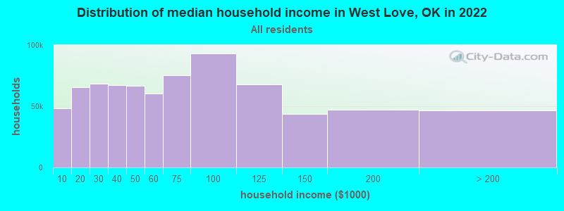
| West Love: | $57,812 |
| OK: | $59,673 |
Estimated per capita income in 2022: $29,286 (it was $17,434 in 2000)
West Love CCD income, earnings, and wages data
Estimated median house or condo value in 2022: $195,049 (it was $58,500 in 2000)
| West Love: | $195,049 |
| OK: | $191,700 |
Mean prices in 2022: all housing units: $222,121; detached houses: $241,644; townhouses or other attached units: $177,291; mobile homes: $135,869
Detailed information about poverty and poor residents in West Love, OK


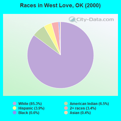
- 1,58585.3%White alone
- 1206.5%American Indian alone
- 723.9%Hispanic
- 643.4%Two or more races
- 110.6%Black alone
- 70.4%Asian alone
Races in West Love detailed stats: ancestries, foreign born residents, place of birth
 Recent articles from our blog. Our writers, many of them Ph.D. graduates or candidates, create easy-to-read articles on a wide variety of topics.
Current Local Time: CST time zone
Land area: 234.3 square miles.
Population density: 8.1 people per square mile (very low).

| West Love CCD: | 0.7% ($390) |
| Oklahoma: | 0.8% ($523) |
Nearest city with pop. 50,000+: East Grayson, TX (52.2 miles  , pop. 81,381).
Nearest city with pop. 200,000+: Plano, TX (71.9 miles , pop. 222,030).
Nearest city with pop. 1,000,000+: Dallas, TX (86.3 miles , pop. 1,188,580).
Nearest cities:
), ), ), Latitude: 33.95 N, Longitude: 97.38 W
Area code commonly used in this area: 580

| Here: | 2.1% |
| Oklahoma: | 3.2% |
- Educational services (12.7%)
- Health care (9.5%)
- Agriculture, forestry, fishing & hunting (9.3%)
- Construction (7.1%)
- Plastics & rubber products (6.7%)
- Accommodation & food services (5.9%)
- Public administration (4.6%)
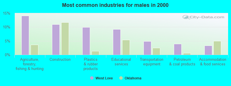
- Agriculture, forestry, fishing & hunting (14.1%)
- Construction (11.0%)
- Plastics & rubber products (9.9%)
- Educational services (9.3%)
- Transportation equipment (4.8%)
- Petroleum & coal products (4.0%)
- Accommodation & food services (3.3%)
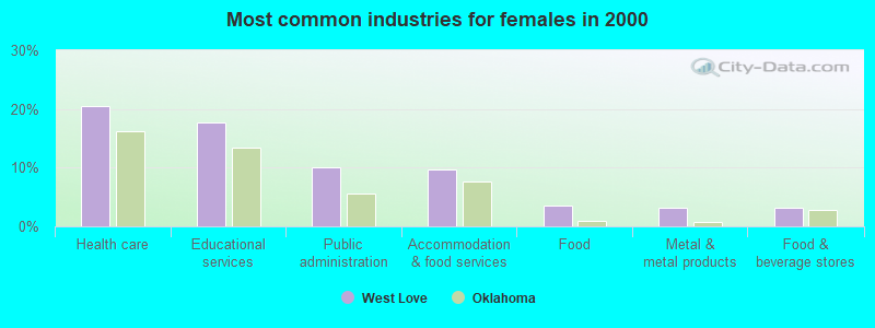
- Health care (20.6%)
- Educational services (17.7%)
- Public administration (10.0%)
- Accommodation & food services (9.6%)
- Food (3.5%)
- Metal & metal products (3.2%)
- Food & beverage stores (3.2%)
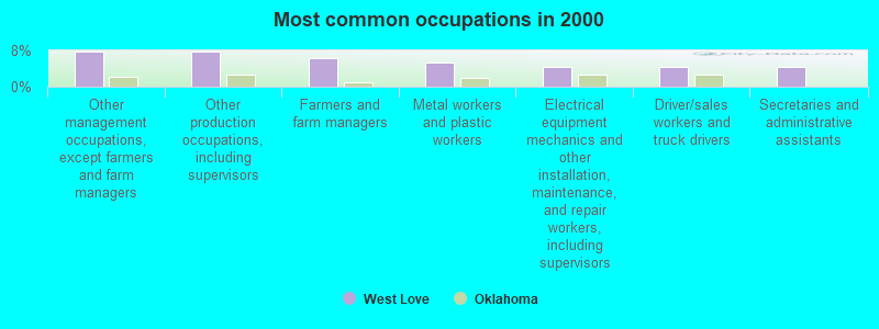
- Other management occupations, except farmers and farm managers (7.8%)
- Other production occupations, including supervisors (7.7%)
- Farmers and farm managers (6.3%)
- Metal workers and plastic workers (5.4%)
- Electrical equipment mechanics and other installation, maintenance, and repair workers, including supervisors (4.4%)
- Driver/sales workers and truck drivers (4.3%)
- Secretaries and administrative assistants (4.3%)
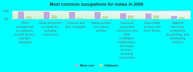
- Other management occupations, except farmers and farm managers (9.7%)
- Other production occupations, including supervisors (9.3%)
- Farmers and farm managers (9.0%)
- Metal workers and plastic workers (9.0%)
- Electrical equipment mechanics and other installation, maintenance, and repair workers, including supervisors (7.5%)
- Driver/sales workers and truck drivers (7.3%)
- Material recording, scheduling, dispatching, and distributing workers (4.0%)
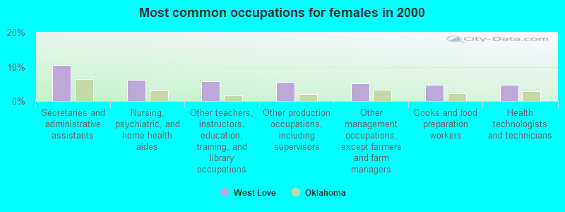
- Secretaries and administrative assistants (10.6%)
- Nursing, psychiatric, and home health aides (6.1%)
- Other teachers, instructors, education, training, and library occupations (5.8%)
- Other production occupations, including supervisors (5.5%)
- Other management occupations, except farmers and farm managers (5.1%)
- Cooks and food preparation workers (4.8%)
- Health technologists and technicians (4.8%)
Average climate in West Love, Oklahoma
Based on data reported by over 4,000 weather stations


(lower is better)
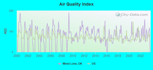
Air Quality Index (AQI) level in 2023 was 91.9. This is worse than average.
| City: | 91.9 |
| U.S.: | 72.6 |
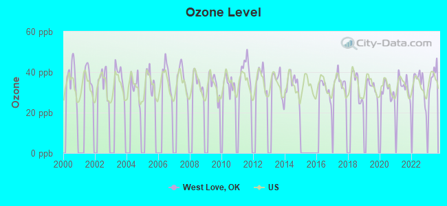
Ozone [ppb] level in 2023 was 37.7. This is about average. Closest monitor was 7.4 miles away from the city center.
| City: | 37.7 |
| U.S.: | 33.3 |
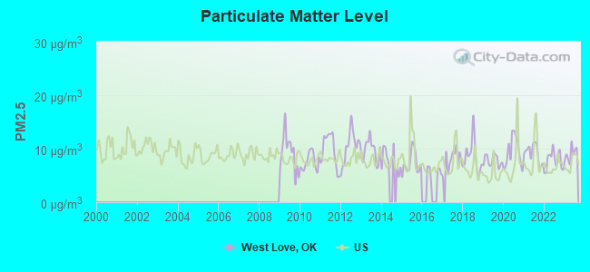
Particulate Matter (PM2.5) [µg/m3] level in 2023 was 9.01. This is about average. Closest monitor was 7.4 miles away from the city center.
| City: | 9.01 |
| U.S.: | 8.11 |
Tornado activity:
West Love-area historical tornado activity is near Oklahoma state average. It is 141% greater than the overall U.S. average.
On 3/13/1953, a category F3 (max. wind speeds 158-206 mph) tornado 6.4 miles away from the West Love place center killed 2 people and injured 11 people and caused between $5000 and $50,000 in damages.
On 4/19/1972, a category F4 (max. wind speeds 207-260 mph) tornado 31.6 miles away from the place center killed 5 people and injured 6 people and caused between $5000 and $50,000 in damages.
Earthquake activity:
West Love-area historical earthquake activity is significantly above Oklahoma state average. It is 619% greater than the overall U.S. average.On 11/6/2011 at 03:53:10, a magnitude 5.7 (5.7 MW, Depth: 3.2 mi, Class: Moderate, Intensity: VI - VII) earthquake occurred 115.0 miles away from the city center
On 9/3/2016 at 12:02:44, a magnitude 5.8 (5.8 MW, Depth: 3.5 mi) earthquake occurred 173.3 miles away from West Love center
On 6/16/1978 at 11:46:54, a magnitude 5.3 (4.4 MB, 4.6 UK, 5.3 ML) earthquake occurred 205.5 miles away from West Love center
On 11/7/2016 at 01:44:24, a magnitude 5.0 (5.0 MW, Depth: 2.8 mi) earthquake occurred 145.1 miles away from the city center
On 11/8/2011 at 02:46:57, a magnitude 4.8 (4.8 MW, Depth: 3.1 mi, Class: Light, Intensity: IV - V) earthquake occurred 114.6 miles away from West Love center
On 11/5/2011 at 07:12:45, a magnitude 4.8 (4.8 MW, Depth: 1.9 mi) earthquake occurred 116.2 miles away from the city center
Magnitude types: body-wave magnitude (MB), local magnitude (ML), moment magnitude (MW)
Natural disasters:
The number of natural disasters in Love County (20) is greater than the US average (15).Major Disasters (Presidential) Declared: 12
Emergencies Declared: 6
Causes of natural disasters: Storms: 12, Floods: 9, Tornadoes: 8, Winter Storms: 6, Winds: 3, Hurricane: 1, Snow: 1, Other: 1 (Note: some incidents may be assigned to more than one category).
Colleges/universities with over 2000 students nearest to West Love:
- North Central Texas College (about 26 miles; Gainesville, TX; Full-time enrollment: 6,550)
- Grayson College (about 46 miles; Denison, TX; FT enrollment: 2,496)
- Texas Woman's University (about 52 miles; Denton, TX; FT enrollment: 11,837)
- University of North Texas (about 53 miles; Denton, TX; FT enrollment: 31,694)
- Southeastern Oklahoma State University (about 58 miles; Durant, OK; FT enrollment: 3,365)
- Midwestern State University (about 66 miles; Wichita Falls, TX; FT enrollment: 4,901)
- Collin County Community College District (about 69 miles; McKinney, TX; FT enrollment: 18,044)
Points of interest:
Notable locations in West Love: Orr Volunteer Fire Department (A), Jimtown Volunteer Fire Department (B), Courtney Volunteer Fire Department (C), Turner Lodge (D), Falconhead Volunteer Fire Department (E), Leon Fire Department (F). Display/hide their locations on the map
Church in West Love: Brushy Mound Church (A). Display/hide its location on the map
Cemeteries: Bourland Cemetery (1), Box Cemetery (2), Rubottom Cemetery (3), Leon Cemetery (4), Jimtown Cemetery (5), Eastman Cemetery (6), Burneyville Cemetery (7). Display/hide their locations on the map
Reservoirs and swamps: Battle Springs Lake (A), Lower Bayou Creek Site 7 Reservoir (B), Lower Bayou Creek Site 17 Reservoir (C), Lower Bayou Creek Site 18 Reservoir (D), Lower Bayou Creek Site 14 Reservoir (E), Lower Bayou Creek Site 13 Reservoir (F), Lower Bayou Creek Site 10 Reservoir (G), James Dula Pond 6 (H). Display/hide their locations on the map
Streams, rivers, and creeks: Bone Creek (A), Coon Creek (B), Coffeepot Creek (C), Sparks Branch (D), Cherokee Creek (E), Simon Creek (F), Cedar Creek (G), Sandy Creek (H), Red Oak Creek (I). Display/hide their locations on the map
| This place: | 2.4 people |
| Oklahoma: | 2.5 people |
| This place: | 71.5% |
| Whole state: | 66.8% |
| This place: | 5.1% |
| Whole state: | 5.9% |
Likely homosexual households (counted as self-reported same-sex unmarried-partner households)
- Lesbian couples: 0.5% of all households
- Gay men: 0.4% of all households
| This place: | 8.6% |
| Whole state: | 14.7% |
| This place: | 3.2% |
| Whole state: | 6.1% |
For population 15 years and over in West Love:
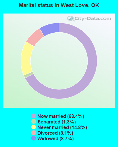
- Never married: 14.8%
- Now married: 68.4%
- Separated: 1.3%
- Widowed: 8.7%
- Divorced: 8.1%
For population 25 years and over in West Love:
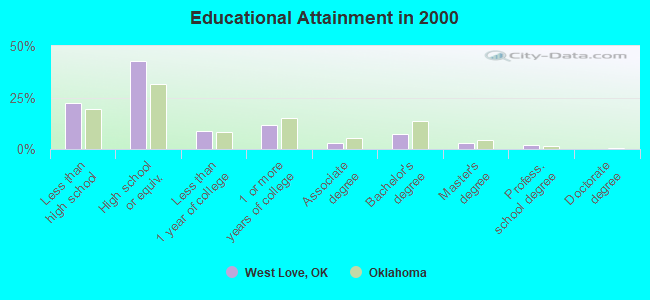
- High school or higher: 77.9%
- Bachelor's degree or higher: 12.0%
- Graduate or professional degree: 4.9%
- Unemployed: 3.5%
- Mean travel time to work (commute): 31.4 minutes
| Here: | 11.3 |
| Oklahoma average: | 11.7 |
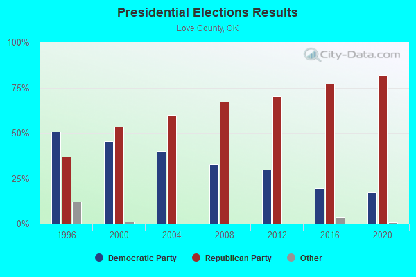
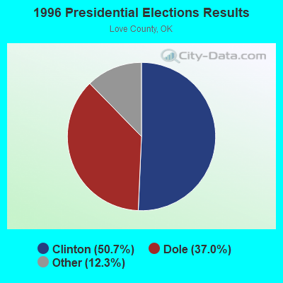
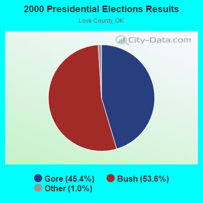
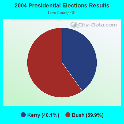
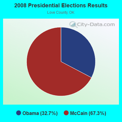
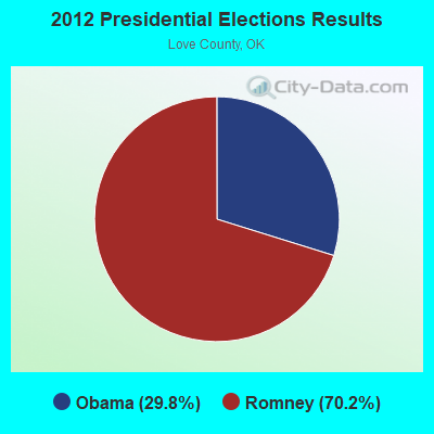
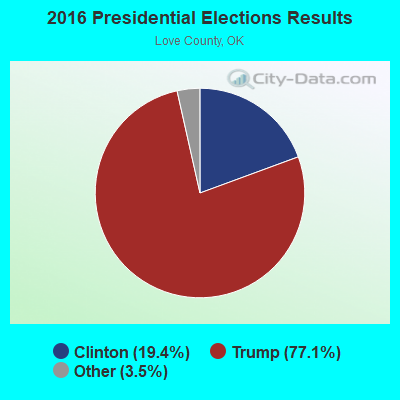
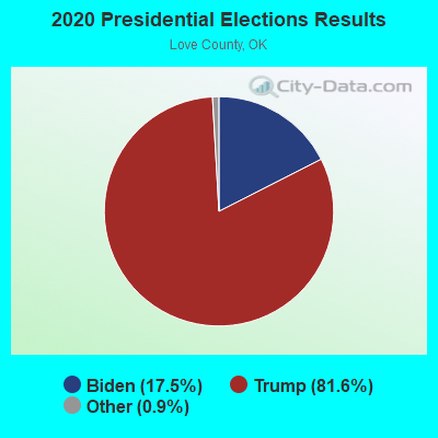
Graphs represent county-level data. Detailed 2008 Election Results
Religion statistics for West Love, OK (based on Love County data)
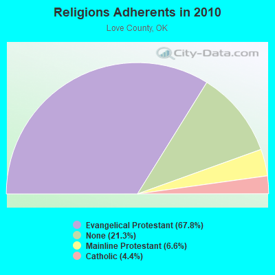
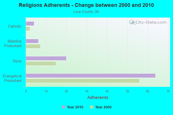
| Religion | Adherents | Congregations |
|---|---|---|
| Evangelical Protestant | 6,386 | 18 |
| Mainline Protestant | 624 | 4 |
| Catholic | 410 | 1 |
| None | 2,003 | - |
Food Environment Statistics:
| This county: | 1.10 / 10,000 pop. |
| Oklahoma: | 1.97 / 10,000 pop. |
| This county: | 2.20 / 10,000 pop. |
| Oklahoma: | 0.76 / 10,000 pop. |
| Love County: | 4.40 / 10,000 pop. |
| State: | 4.35 / 10,000 pop. |
| Love County: | 5.50 / 10,000 pop. |
| State: | 6.89 / 10,000 pop. |
| This county: | 12.2% |
| State: | 10.3% |
| Love County: | 29.2% |
| Oklahoma: | 29.2% |
Strongest AM radio stations in West Love:
- WBAP (820 AM; 50 kW; FORT WORTH, TX; Owner: WBAP-KSCS OPERATING, LTD.)
- KRLD (1080 AM; 50 kW; DALLAS, TX; Owner: TEXAS INFINITY BROADCASTING L.P.)
- KAHZ (1360 AM; 50 kW; HURST, TX)
- KESS (1270 AM; 50 kW; FORT WORTH, TX; Owner: KESS-AM LICENSE CORP.)
- KFXR (1190 AM; 50 kW; DALLAS, TX; Owner: CLEAR CHANNEL BROADCASTING LICENSES, INC.)
- KZMP (1540 AM; 50 kW; UNIVERSITY PARK, TX; Owner: ENTRAVISION HOLDINGS, LLC)
- KYNG (950 AM; 10 kW; DENISON-SHERMAN, TX; Owner: KRBE LICO, INC.)
- KBIS (1150 AM; 25 kW; HIGHLAND PARK, TX; Owner: DALLAS AM RADIO PARTNERS, L.P.)
- KOMA (1520 AM; 50 kW; OKLAHOMA CITY, OK; Owner: RENDA BROADCASTING CORP. OF NEVADA)
- KSKY (660 AM; 20 kW; BALCH SPRINGS, TX; Owner: BISON MEDIA, INC.)
- KTNO (1440 AM; 12 kW; DENTON, TX; Owner: MORTENSON BROADCASTING COMPANY)
- KRMG (740 AM; 50 kW; TULSA, OK; Owner: CXR HOLDINGS, INC.)
- KTBK (1700 AM; 10 kW; SHERMAN, TX; Owner: KRBE LICO, INC.)
Strongest FM radio stations in West Love:
- KTCY (104.9 FM; PILOT POINT, TX; Owner: ENTRAVISION HOLDINGS, LLC)
- KWRD-FM (100.7 FM; HIGHLAND VILLAGE, TX; Owner: INSPIRATION MEDIA OF TEXAS, L.L.C.)
- KNOR (93.7 FM; HEALDTON, OK; Owner: AM & PM BROADCASTERS, LLC)
- KMEO (96.7 FM; FLOWER MOUND, TX; Owner: ABC, INC.)
- KKDL (106.7 FM; MUENSTER, TX; Owner: ENTRAVISION HOLDINGS, LLC)
- KZMP-FM (101.7 FM; AZLE, TX; Owner: ENTRAVISION HOLDINGS, LLC)
- KESN (103.3 FM; ALLEN, TX; Owner: WBAP-KSCS OPERATING, LTD.)
- KSOC (94.5 FM; GAINESVILLE, TX; Owner: RADIO ONE LICENSES, LLC)
- KESS-FM (107.9 FM; LEWISVILLE, TX; Owner: KECS-FM LICENSE CORPORATION)
- KTPW (89.7 FM; SANGER, TX; Owner: RESEARCH EDUCATIONAL FOUNDATION, INC)
- KRNB (105.7 FM; DECATUR, TX; Owner: SERVICE BROADCASTING I, LTD.)
- KDKR (91.3 FM; DECATUR, TX; Owner: CSN INTERNATIONAL)
- KHCK-FM (99.1 FM; DENTON, TX; Owner: KHCK-FM LICENSE CORP.)
- KKAJ-FM (95.7 FM; ARDMORE, OK; Owner: NM LICENSING, LLC)
- KYNZ (107.1 FM; LONE GROVE, OK; Owner: CHUCKIE BROADCASTING COMPANY)
- KMAD-FM (102.5 FM; WHITESBORO, TX; Owner: NM LICENSING, LLC)
- KTRX (92.7 FM; DICKSON, OK; Owner: NM LICENSING, LLC)
- KICM (97.7 FM; HEALDTON, OK; Owner: ON THE AIR, INC.)
- KACO (98.5 FM; ARDMORE, OK; Owner: A.M. & P.M. COMMUNICATIONS, L.L.C.)
TV broadcast stations around West Love:
- KXII (Channel 12; SHERMAN, TX; Owner: KXII LICENSEE CORP.)
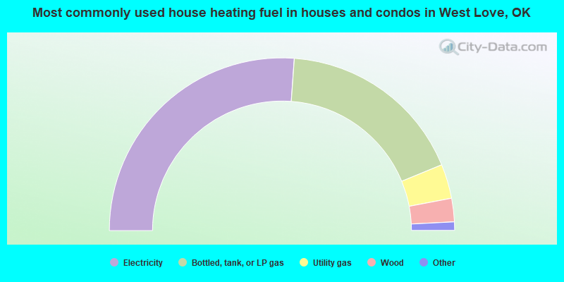
- 52.3%Electricity
- 35.3%Bottled, tank, or LP gas
- 6.4%Utility gas
- 4.4%Wood
- 1.0%Fuel oil, kerosene, etc.
- 0.6%Other fuel
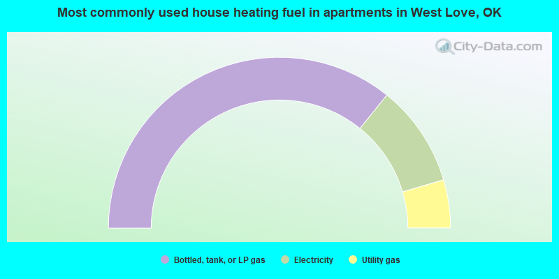
- 71.6%Bottled, tank, or LP gas
- 19.3%Electricity
- 9.1%Utility gas
West Love compared to Oklahoma state average:
- Unemployed percentage significantly below state average.
- Black race population percentage significantly below state average.
- Hispanic race population percentage significantly below state average.
- Median age significantly above state average.
- Foreign-born population percentage significantly below state average.
- Renting percentage significantly below state average.
- Length of stay since moving in significantly above state average.
- Number of rooms per house significantly below state average.
- House age significantly below state average.
- Number of college students below state average.
- Percentage of population with a bachelor's degree or higher below state average.