West Liberty, Florida
Submit your own pictures of this place and show them to the world
- OSM Map
- General Map
- Google Map
- MSN Map

| Males: 3,693 | |
| Females: 2,249 |
| Median resident age: | 34.5 years |
| Florida median age: | 38.7 years |
Zip code: 32321
| West Liberty: | $51,177 |
| FL: | $69,303 |
Estimated per capita income in 2022: $23,201 (it was $16,008 in 2000)
West Liberty CCD income, earnings, and wages data
Estimated median house or condo value in 2022: $135,100 (it was $49,100 in 2000)
| West Liberty: | $135,100 |
| FL: | $354,100 |
Mean prices in 2022: all housing units: $183,421; detached houses: $215,507; townhouses or other attached units: $325,531; mobile homes: $94,717
Detailed information about poverty and poor residents in West Liberty, FL
Compare current foreclosures near West Liberty, FL:
| Photo | Address | Area | Beds / Baths | Price | Details |
|---|---|---|---|---|---|

|
#1
State Road 71
Altha, FL 32421
|
1,894 sq. feet
|
2 baths 4 beds |
show details | |

|
#2
SE Sherry Ave
Blountstown, FL 32424
|
2,382 sq. feet
|
2 baths 3 beds |
show details | |

|
#3
NE Burns Ave
Blountstown, FL 32424
|
1,698 sq. feet
|
2 baths 2 beds |
show details | |

|
#4
SE Main St
Blountstown, FL 32424
|
1,428 sq. feet
|
1 baths 2 beds |
show details | |

|
#5
NE Fire Break 21
Hosford, FL 32334
|
840 sq. feet
|
1 baths 2 beds |
show details | |

|
#6
SE County Road 69
Blountstown, FL 32424
|
- sq. feet
|
- baths - beds |
show details | |

|
#7
NW Ashley Shiver Rd
Altha, FL 32421
|
- sq. feet
|
- baths - beds |
show details | |

|
#8
NW Martin L King Rd
Bristol, FL 32321
|
- sq. feet
|
- baths - beds |
show details | |

|
#9
NW Martin L King Rd
Bristol, FL 32321
|
- sq. feet
|
- baths - beds |
show details | |

|
#10
State Rd 20 West
Blountstown, FL 32424
|
- sq. feet
|
- baths - beds |
show details |
| Photo | Address | Area | Beds / Baths | Price | Details |
|---|---|---|---|---|---|

|
#11
NE Blue Creek Rd
Hosford, FL 32334
|
- sq. feet
|
- baths - beds |
show details | |

|
#12
NW Myers Ann St
Bristol, FL 32321
|
- sq. feet
|
- baths - beds |
show details | |

|
#13
NE Cannon Branch Rd
Hosford, FL 32334
|
- sq. feet
|
- baths - beds |
show details | |

|
#14
NE Marie Ave
Blountstown, FL 32424
|
- sq. feet
|
- baths - beds |
show details | |

|
#15
SE Martin Luther King Ave
Blountstown, FL 32424
|
- sq. feet
|
- baths - beds |
show details | |

|
#16
NW Bird Pond Rd
Bristol, FL 32321
|
- sq. feet
|
- baths - beds |
show details | |

|
#17
NW Paradise Ln
Altha, FL 32421
|
- sq. feet
|
- baths - beds |
show details | |

|
Check over 1 million property listings on Foreclosure.com!
|
browse all offers | |||

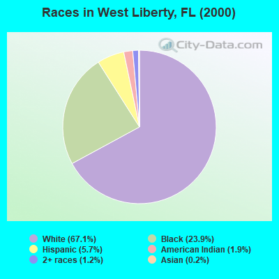
- 3,57567.1%White alone
- 1,27323.9%Black alone
- 3045.7%Hispanic
- 1031.9%American Indian alone
- 631.2%Two or more races
- 90.2%Asian alone
- 40.08%Other race alone
Races in West Liberty detailed stats: ancestries, foreign born residents, place of birth
 Recent articles from our blog. Our writers, many of them Ph.D. graduates or candidates, create easy-to-read articles on a wide variety of topics.
Current Local Time: EST time zone
Land area: 347.5 square miles.
Population density: 17 people per square mile (very low).

| West Liberty CCD: | 0.8% ($383) |
| Florida: | 1.4% ($1,262) |
Nearest city with pop. 50,000+: Tallahassee, FL  (43.7 miles , pop. 150,624).
Nearest city with pop. 200,000+: Montgomery, AL (161.4 miles , pop. 201,568).
Nearest city with pop. 1,000,000+: Houston, TX (623.5 miles , pop. 1,953,631).
Nearest cities:
), ), ), )Latitude: 30.31 N, Longitude: 84.99 W
Area code commonly used in this area: 850

| Here: | 3.2% |
| Florida: | 2.9% |
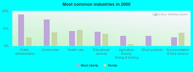
- Public administration (18.2%)
- Construction (15.3%)
- Health care (8.7%)
- Educational services (8.2%)
- Agriculture, forestry, fishing & hunting (6.0%)
- Wood products (5.9%)
- Accommodation & food services (5.2%)
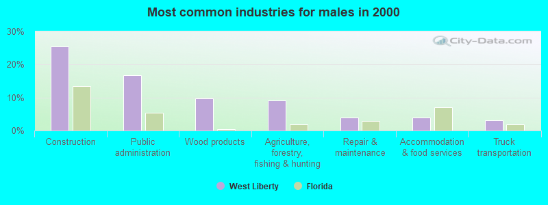
- Construction (25.4%)
- Public administration (16.8%)
- Wood products (9.7%)
- Agriculture, forestry, fishing & hunting (9.1%)
- Repair & maintenance (4.0%)
- Accommodation & food services (3.8%)
- Truck transportation (3.2%)
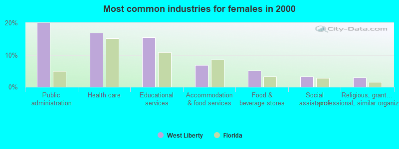
- Public administration (19.9%)
- Health care (16.9%)
- Educational services (15.5%)
- Accommodation & food services (6.9%)
- Food & beverage stores (5.2%)
- Social assistance (3.3%)
- Religious, grantmaking, civic, professional, similar organizations (2.9%)
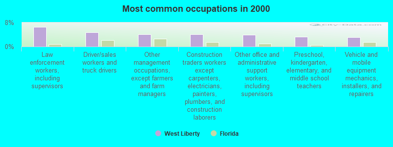
- Law enforcement workers, including supervisors (6.5%)
- Driver/sales workers and truck drivers (4.7%)
- Other management occupations, except farmers and farm managers (4.1%)
- Construction traders workers except carpenters, electricians, painters, plumbers, and construction laborers (4.0%)
- Other office and administrative support workers, including supervisors (4.0%)
- Preschool, kindergarten, elementary, and middle school teachers (3.2%)
- Vehicle and mobile equipment mechanics, installers, and repairers (3.2%)
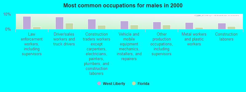
- Law enforcement workers, including supervisors (8.6%)
- Driver/sales workers and truck drivers (8.1%)
- Construction traders workers except carpenters, electricians, painters, plumbers, and construction laborers (6.7%)
- Vehicle and mobile equipment mechanics, installers, and repairers (5.6%)
- Other production occupations, including supervisors (4.8%)
- Metal workers and plastic workers (4.4%)
- Construction laborers (4.1%)
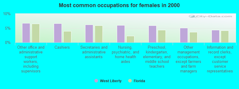
- Other office and administrative support workers, including supervisors (6.7%)
- Cashiers (6.6%)
- Secretaries and administrative assistants (6.2%)
- Nursing, psychiatric, and home health aides (6.0%)
- Preschool, kindergarten, elementary, and middle school teachers (5.9%)
- Other management occupations, except farmers and farm managers (5.0%)
- Information and record clerks, except customer service representatives (4.3%)
Average climate in West Liberty, Florida
Based on data reported by over 4,000 weather stations


(lower is better)
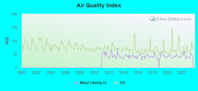
Air Quality Index (AQI) level in 2023 was 43.6. This is significantly better than average.
| City: | 43.6 |
| U.S.: | 72.6 |
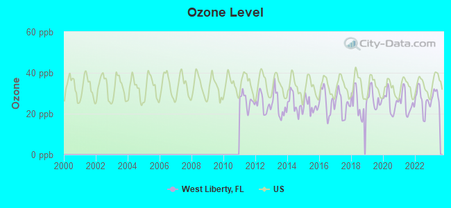
Ozone [ppb] level in 2023 was 28.6. This is about average. Closest monitor was 13.5 miles away from the city center.
| City: | 28.6 |
| U.S.: | 33.3 |
Tornado activity:
West Liberty-area historical tornado activity is near Florida state average. It is 1% greater than the overall U.S. average.
On 12/10/1967, a category F3 (max. wind speeds 158-206 mph) tornado 35.0 miles away from the West Liberty place center killed one person and injured 50 people and caused between $500,000 and $5,000,000 in damages.
On 12/28/1968, a category F3 tornado 37.3 miles away from the place center caused between $5000 and $50,000 in damages.
Earthquake activity:
West Liberty-area historical earthquake activity is significantly above Florida state average. It is 72% smaller than the overall U.S. average.On 9/10/2006 at 14:56:08, a magnitude 5.9 (5.9 MB, 5.5 MS, 5.8 MW, Class: Moderate, Intensity: VI - VII) earthquake occurred 297.9 miles away from West Liberty center
On 10/24/1997 at 08:35:17, a magnitude 4.9 (4.8 MB, 4.2 MS, 4.9 LG, Depth: 6.2 mi, Class: Light, Intensity: IV - V) earthquake occurred 147.2 miles away from the city center
On 1/18/1999 at 07:00:53, a magnitude 4.8 (4.8 MB, 4.0 LG, Depth: 0.6 mi) earthquake occurred 252.4 miles away from the city center
On 8/2/1974 at 08:52:09, a magnitude 4.9 (4.3 MB, 4.9 LG) earthquake occurred 286.8 miles away from West Liberty center
On 4/29/2003 at 08:59:39, a magnitude 4.9 (4.4 MB, 4.6 MW, 4.9 LG) earthquake occurred 292.1 miles away from West Liberty center
On 5/6/2018 at 16:47:09, a magnitude 4.6 (4.6 MB, Depth: 6.2 mi) earthquake occurred 279.5 miles away from the city center
Magnitude types: regional Lg-wave magnitude (LG), body-wave magnitude (MB), surface-wave magnitude (MS), moment magnitude (MW)
Natural disasters:
The number of natural disasters in Liberty County (23) is greater than the US average (15).Major Disasters (Presidential) Declared: 13
Emergencies Declared: 5
Causes of natural disasters: Hurricanes: 10, Tropical Storms: 7, Fires: 3, Floods: 3, Storms: 3, Tornadoes: 2, Wind: 1, Other: 1 (Note: some incidents may be assigned to more than one category).
Hospitals and medical centers near West Liberty:
Colleges/universities with over 2000 students nearest to West Liberty:
- Tallahassee Community College (about 40 miles; Tallahassee, FL; Full-time enrollment: 10,904)
- Florida State University (about 43 miles; Tallahassee, FL; FT enrollment: 38,283)
- Florida Agricultural and Mechanical University (about 43 miles; Tallahassee, FL; FT enrollment: 10,841)
- Gulf Coast State College (about 46 miles; Panama City, FL; FT enrollment: 4,474)
- Bainbridge State College (about 50 miles; Bainbridge, GA; FT enrollment: 2,308)
- George C Wallace State Community College-Dothan (about 76 miles; Dothan, AL; FT enrollment: 3,611)
- Enterprise State Community College (about 86 miles; Enterprise, AL; FT enrollment: 2,101)
Points of interest:
Notable locations in West Liberty: Sheppards Landing (A), Big Gully Landing (B), Liberty County Correctional Institute (C), Brushy Crossing (D), Cotton Landing (E), Ranger Station (F), Shingle Landing (G), Larkin Fish Camp (H), Smokehouse Crossing (I), Big Gully Landing Campground (J), Rock Bluff Landing (K), Graveyard Pole Lookout (L), Wilma Work Center (M), Gunn Landing (N), Muscogee Landing (O), Kennedy Creek Fish Camp (P), Cotton Landing Campground (Q), WHite Oak Landing Campground (R), Camel Lake Campground (S), Apalachicola Work Center (T). Display/hide their locations on the map
Churches in West Liberty include: Saint Luke Church (A), Rock of Will Church (B), Lake Mystic Church (C), Victory Temple (D), Saint Stephens Church (E), Humility Church (F), Eureka Church (G), Humility Church (H), Hawkins Lane Church (I). Display/hide their locations on the map
Cemeteries: Mitchum Cemetery (1), Nixon Garden Cemetery (2), Bristol Cemetery (3), Humility Cemetery (4), Orange Cemetery (5). Display/hide their locations on the map
Lakes and swamps: Fields Lake (A), Fish Pond (B), Franklin Pond (C), Greenback Lake (D), Half Open Pond (E), Turner Lake (F), Solomon Lake (G), Landy Lake (H). Display/hide their locations on the map
Streams, rivers, and creeks: East Minnow Branch (A), Spots Branch (B), Bracel Branch (C), Viney Branch (D), River Styx (E), South Creek (F), Sand Branch (G), Salty Branch (H), Rock Creek (I). Display/hide their locations on the map
Park in West Liberty: Torreya State Park (1). Display/hide its location on the map
| This place: | 2.6 people |
| Florida: | 2.5 people |
| This place: | 71.0% |
| Whole state: | 65.2% |
| This place: | 6.5% |
| Whole state: | 7.3% |
Likely homosexual households (counted as self-reported same-sex unmarried-partner households)
- Lesbian couples: 0.4% of all households
- Gay men: 0.1% of all households
| This place: | 20.9% |
| Whole state: | 12.5% |
| This place: | 10.5% |
| Whole state: | 5.7% |
People in group quarters in West Liberty in 2010:
- 1,702 people in state prisons
- 61 people in local jails and other municipal confinement facilities
- 39 people in residential treatment centers for juveniles (non-correctional)
- 34 people in group homes intended for adults
- 26 people in correctional facilities intended for juveniles
- 20 people in nursing facilities/skilled-nursing facilities
People in group quarters in West Liberty in 2000:
- 1,325 people in state prisons
- 39 people in other noninstitutional group quarters
- 33 people in homes for abused, dependent, and neglected children
- 14 people in homes for the mentally ill
- 12 people in local jails and other confinement facilities (including police lockups)
- 8 people in homes for the mentally retarded
For population 15 years and over in West Liberty:
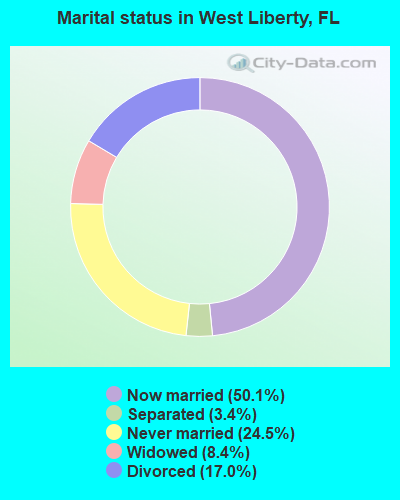
- Never married: 24.5%
- Now married: 50.1%
- Separated: 3.4%
- Widowed: 8.4%
- Divorced: 17.0%
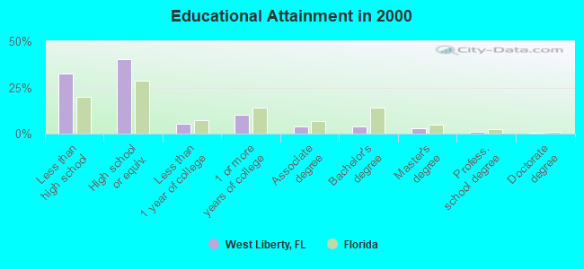
For population 25 years and over in West Liberty:
- High school or higher: 67.5%
- Bachelor's degree or higher: 8.1%
- Graduate or professional degree: 4.1%
- Unemployed: 6.5%
- Mean travel time to work (commute): 32.3 minutes
| Here: | 12.5 |
| Florida average: | 12.6 |
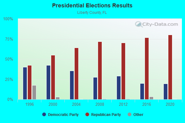
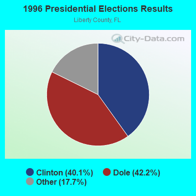
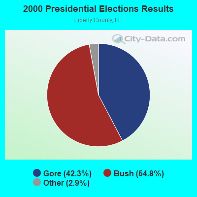
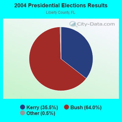

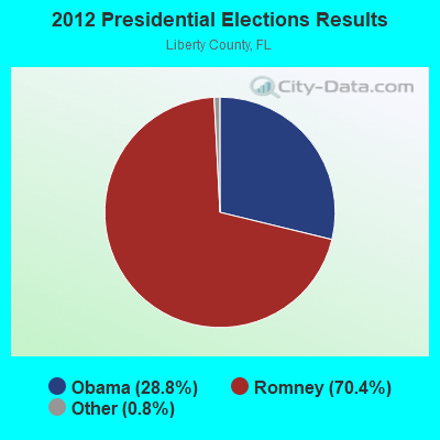
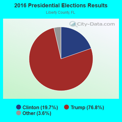
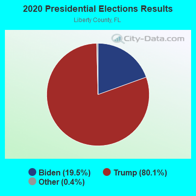
Graphs represent county-level data. Detailed 2008 Election Results
Religion statistics for West Liberty, FL (based on Liberty County data)
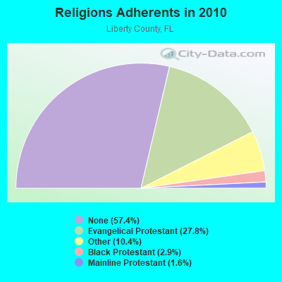
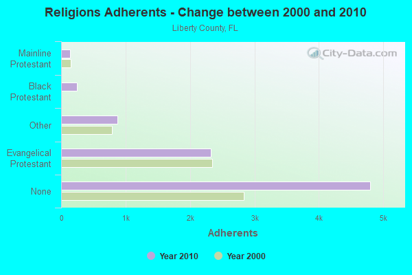
| Religion | Adherents | Congregations |
|---|---|---|
| Evangelical Protestant | 2,322 | 15 |
| Other | 869 | 2 |
| Black Protestant | 240 | 2 |
| Mainline Protestant | 134 | 2 |
| None | 4,800 | - |
Food Environment Statistics:
| Liberty County: | 2.56 / 10,000 pop. |
| Florida: | 2.04 / 10,000 pop. |
| Liberty County: | 2.56 / 10,000 pop. |
| Florida: | 1.28 / 10,000 pop. |
| Liberty County: | 6.40 / 10,000 pop. |
| State: | 3.04 / 10,000 pop. |
| This county: | 1.28 / 10,000 pop. |
| Florida: | 7.45 / 10,000 pop. |
| This county: | 10.9% |
| Florida: | 9.2% |
| Liberty County: | 34.1% |
| Florida: | 23.7% |
| Here: | 9.7% |
| Florida: | 14.0% |
Strongest AM radio stations in West Liberty:
- WYBT (1000 AM; daytime; 5 kW; BLOUNTSTOWN, FL; Owner: BLOUNTSTOWN COMMUNICATIONS, INC.)
- WSTT (730 AM; 25 kW; THOMASVILLE, GA; Owner: MARION R. WILLIAMS)
- WTCL (1580 AM; daytime; 10 kW; CHATTAHOOCHEE, FL; Owner: METZ, INC.)
- WFRF (1070 AM; daytime; 10 kW; TALLAHASSEE, FL; Owner: FAITH RADIO NETWORK, INC.)
- WFVR (910 AM; 50 kW; VALDOSTA, GA; Owner: RAMA COMMUNICATIONS, INC.)
- WDIZ (590 AM; 2 kW; PANAMA CITY, FL; Owner: CLEAR CHANNEL BROADCASTING LICENSES, INC.)
- WLTG (1430 AM; 5 kW; PANAMA CITY, FL; Owner: HOUR GROUP BROADCASTING, INC.)
- WNLS (1270 AM; 5 kW; TALLAHASSEE, FL; Owner: CLEAR CHANNEL BROADCASTING LICENSES, INC.)
- WHGH (840 AM; daytime; 10 kW; THOMASVILLE, GA; Owner: H. G. H INVESTMENT CORP.)
- WMGR (930 AM; 5 kW; BAINBRIDGE, GA; Owner: DECATUR BROADCASTING, INC.)
- WOKV (690 AM; 50 kW; JACKSONVILLE, FL; Owner: COX RADIO, INC.)
- WCVC (1330 AM; daytime; 5 kW; TALLAHASSEE, FL)
- WHBT (1410 AM; 5 kW; TALLAHASSEE, FL)
Strongest FM radio stations in West Liberty:
- WPAP-FM (92.5 FM; PANAMA CITY, FL; Owner: CLEAR CHANNEL BROADCASTING LICENSES, INC.)
- WLHR (107.9 FM; PANAMA CITY, FL; Owner: WAITT BROADCASTING OF FLORIDA, L.L.C.)
- WPHK (102.7 FM; BLOUNTSTOWN, FL; Owner: BLOUNTSTOWN COMMUNICATIONS, INC.)
- WFSY (98.5 FM; PANAMA CITY, FL; Owner: CLEAR CHANNEL BROADCASTING LICENSES, INC.)
- WFSQ (91.5 FM; TALLAHASSEE, FL; Owner: FLORIDA STATE UNIVERSITY)
- WMXP (103.5 FM; CALLAWAY, FL; Owner: WAITT BROADCASTING OF FLORIDA, L.L.C.)
- WYYX (97.7 FM; BONIFAY, FL; Owner: STYLES MEDIA GROUP, LLC)
- WFBX (94.5 FM; PARKER, FL; Owner: CLEAR CHANNEL BROADCASTING LICENSES, INC.)
- WWLD (102.3 FM; CAIRO, GA; Owner: CUMULUS LICENSING CORP.)
- WZND (105.3 FM; HEADLAND, AL; Owner: GULF SOUTH COMMUNICATIONS, INC.)
- WGWD (93.3 FM; GRETNA, FL; Owner: DE-COL INCORPORATED)
- WBWT (100.7 FM; MIDWAY, FL; Owner: CLEAR CHANNEL BROADCASTING LICENSES, INC.)
TV broadcast stations around West Liberty:
- WMBB (Channel 13; PANAMA CITY, FL; Owner: MEDIA GENERAL BROADCASTING OF SO. CAROLINA HOLDINGS, INC.)
- WFSU-TV (Channel 11; TALLAHASSEE, FL; Owner: FLORIDA STATE UNIVERSITY)
- WJHG-TV (Channel 7; PANAMA CITY, FL; Owner: WJHG LICENSEE CORP.)
- WBIF (Channel 51; MARIANNA, FL; Owner: MARIANNA BROADCASTING, INC.)
- WTLH (Channel 49; BAINBRIDGE, GA; Owner: WTLH LICENSE CORP.)
- WTXL-TV (Channel 27; TALLAHASSEE, FL; Owner: MEDIA VENTURE MANAGEMENT, INC.)
- WPGX (Channel 28; PANAMA CITY, FL; Owner: WAITT LICENSE CO. OF FLORIDA, INC.)
- WPCT (Channel 46; PANAMA CITY BEACH, FL; Owner: BEACH TV PROPERTIES, INC.)
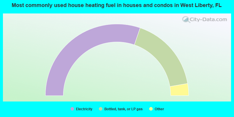
- 60.5%Electricity
- 34.1%Bottled, tank, or LP gas
- 3.0%Wood
- 1.5%Utility gas
- 0.6%Fuel oil, kerosene, etc.
- 0.2%No fuel used
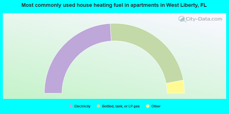
- 48.0%Electricity
- 45.9%Bottled, tank, or LP gas
- 3.6%Utility gas
- 2.5%No fuel used
West Liberty compared to Florida state average:
- Median house value significantly below state average.
- Unemployed percentage below state average.
- Hispanic race population percentage significantly below state average.
- Median age below state average.
- Foreign-born population percentage significantly below state average.
- Length of stay since moving in significantly above state average.
- Number of rooms per house significantly below state average.
- House age significantly below state average.
- Institutionalized population percentage significantly above state average.
- Number of college students below state average.
- Percentage of population with a bachelor's degree or higher significantly below state average.
West Liberty on our top lists:
- #3 on the list of "Top 101 cities with largest percentage of females in occupations: pipelayers, plumbers, pipefitters, and steamfitters (population 5,000+)"
- #8 on the list of "Top 101 cities with largest percentage of males in occupations: other construction workers and helpers (population 5,000+)"
- #11 on the list of "Top 101 cities with largest percentage of females in occupations: judges, magistrates, and other judicial workers (population 5,000+)"
- #12 on the list of "Top 101 cities with largest percentage of females in industries: sporting goods, camera, and hobby and toy stores (population 5,000+)"
- #16 on the list of "Top 101 cities with largest percentage of males in industries: wood products (population 5,000+)"
- #24 on the list of "Top 101 cities with largest percentage of males in occupations: woodworkers (population 5,000+)"
- #26 on the list of "Top 101 cities with largest percentage of females in industries: building material and garden equipment and supplies dealers (population 5,000+)"
- #29 on the list of "Top 101 cities with largest percentage of males in occupations: construction trades workers except carpenters, electricians, painters, plumbers, and construction laborers (population 5,000+)"
- #32 on the list of "Top 101 cities with the most people carpooling to work (population 5,000+)"
- #42 on the list of "Top 101 cities with the largest house values disparities (population 5,000+)"
- #44 on the list of "Top 101 cities with the largest percentage of people in homes for abused, dependent, and neglected children (population 1,000+)"
- #50 on the list of "Top 100 cities with the largest percentage of males (pop. 5,000+)"
- #51 on the list of "Top 101 cities with largest percentage of males in occupations: construction laborers (population 5,000+)"
- #51 on the list of "Top 101 cities with largest percentage of females in industries: miscellaneous nondurable goods merchant wholesalers (population 5,000+)"
- #58 on the list of "Top 101 cities with largest percentage of females in industries: data processing, libraries, and other information services (population 5,000+)"
- #61 on the list of "Top 101 cities with largest percentage of females in industries: pharmacies and drug stores (population 5,000+)"
- #63 on the list of "Top 101 cities with largest percentage of females in industries: wood products (population 5,000+)"
- #66 on the list of "Top 101 cities with largest percentage of females in industries: public administration (population 5,000+)"
- #74 on the list of "Top 101 cities with the largest percentage of mobile homes (2,000+ housing units)"
- #89 on the list of "Top 101 cities with the largest percentage of people in state prisons (population 1,000+)"