West Colusa, California
Submit your own pictures of this place and show them to the world
- OSM Map
- General Map
- Google Map
- MSN Map

| Males: 572 | |
| Females: 449 |
| Median resident age: | 40.7 years |
| California median age: | 33.3 years |
Zip code: 95979
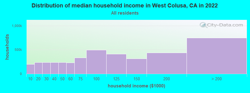
| West Colusa: | $57,416 |
| CA: | $91,551 |
Estimated per capita income in 2022: $33,491 (it was $15,103 in 2000)
West Colusa CCD income, earnings, and wages data
Estimated median house or condo value in 2022: $329,720 (it was $93,600 in 2000)
| West Colusa: | $329,720 |
| CA: | $715,900 |
Detailed information about poverty and poor residents in West Colusa, CA


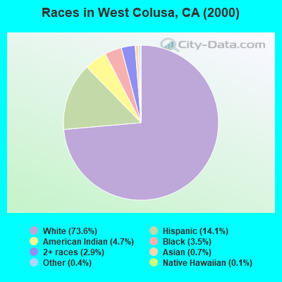
- 67173.6%White alone
- 12914.1%Hispanic
- 434.7%American Indian alone
- 323.5%Black alone
- 262.9%Two or more races
- 60.7%Asian alone
- 40.4%Other race alone
- 10.1%Native Hawaiian and Other
Pacific Islander alone
 Recent articles from our blog. Our writers, many of them Ph.D. graduates or candidates, create easy-to-read articles on a wide variety of topics.
Current Local Time: PST time zone
Land area: 560.2 square miles.
Population density: 1.8 people per square mile (very low).

| West Colusa CCD: | 0.7% ($620) |
| California: | 0.8% ($1,564) |
Nearest city with pop. 50,000+: Chico, CA  (48.3 miles , pop. 59,954).
Nearest city with pop. 200,000+: Sacramento, CA (74.6 miles , pop. 407,018).
Nearest city with pop. 1,000,000+: Los Angeles, CA (425.4 miles , pop. 3,694,820).
Nearest cities:
), )Latitude: 39.27 N, Longitude: 122.51 W
Area code commonly used in this area: 530

| Here: | 16.2% |
| California: | 5.1% |
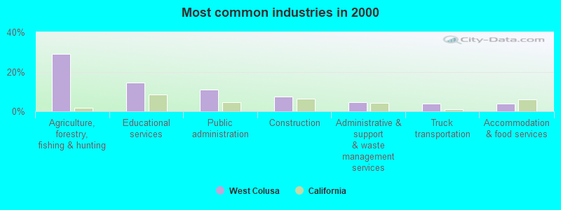
- Agriculture, forestry, fishing & hunting (28.9%)
- Educational services (14.6%)
- Public administration (10.9%)
- Construction (7.5%)
- Administrative & support & waste management services (4.6%)
- Truck transportation (3.8%)
- Accommodation & food services (3.8%)
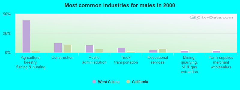
- Agriculture, forestry, fishing & hunting (42.0%)
- Construction (12.6%)
- Public administration (9.8%)
- Truck transportation (6.3%)
- Educational services (3.5%)
- Mining, quarrying, oil & gas extraction (2.8%)
- Farm supplies merchant wholesalers (2.8%)
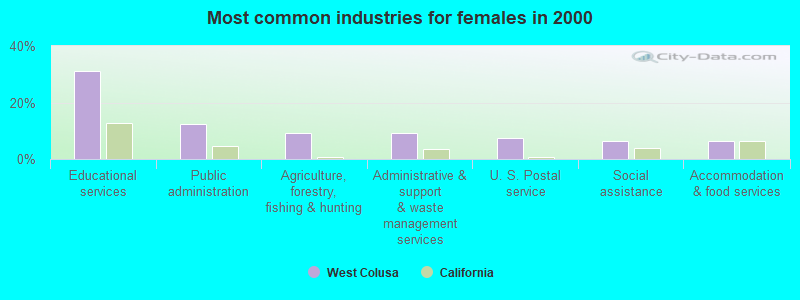
- Educational services (31.2%)
- Public administration (12.5%)
- Agriculture, forestry, fishing & hunting (9.4%)
- Administrative & support & waste management services (9.4%)
- U. S. Postal service (7.3%)
- Social assistance (6.2%)
- Accommodation & food services (6.2%)
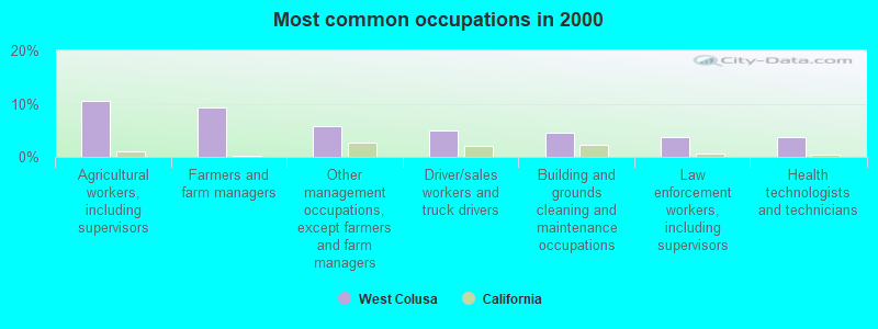
- Agricultural workers, including supervisors (10.5%)
- Farmers and farm managers (9.2%)
- Other management occupations, except farmers and farm managers (5.9%)
- Driver/sales workers and truck drivers (5.0%)
- Building and grounds cleaning and maintenance occupations (4.6%)
- Law enforcement workers, including supervisors (3.8%)
- Health technologists and technicians (3.8%)
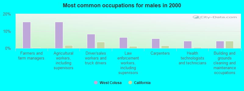
- Farmers and farm managers (15.4%)
- Agricultural workers, including supervisors (15.4%)
- Driver/sales workers and truck drivers (8.4%)
- Law enforcement workers, including supervisors (6.3%)
- Carpenters (5.6%)
- Health technologists and technicians (4.2%)
- Building and grounds cleaning and maintenance occupations (4.2%)
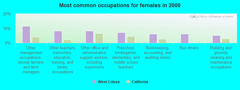
- Other management occupations, except farmers and farm managers (11.5%)
- Other teachers, instructors, education, training, and library occupations (8.3%)
- Other office and administrative support workers, including supervisors (8.3%)
- Preschool, kindergarten, elementary, and middle school teachers (7.3%)
- Bookkeeping, accounting, and auditing clerks (6.2%)
- Bus drivers (6.2%)
- Building and grounds cleaning and maintenance occupations (5.2%)
Average climate in West Colusa, California
Based on data reported by over 4,000 weather stations


(lower is better)
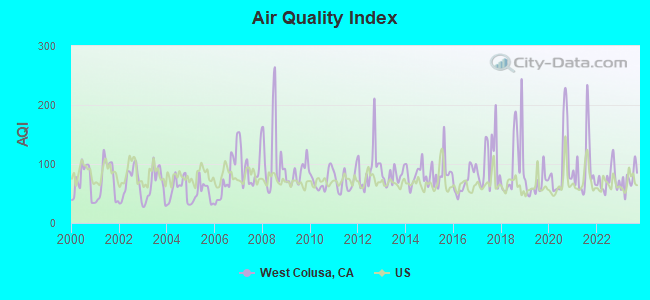
Air Quality Index (AQI) level in 2023 was 74.5. This is about average.
| City: | 74.5 |
| U.S.: | 72.6 |
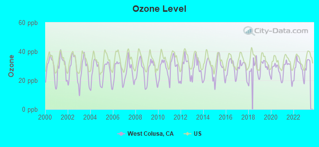
Ozone [ppb] level in 2022 was 28.1. This is about average. Closest monitor was 23.1 miles away from the city center.
| City: | 28.1 |
| U.S.: | 33.3 |
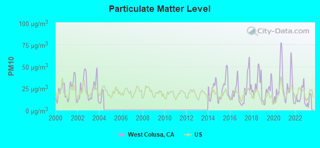
Particulate Matter (PM10) [µg/m3] level in 2022 was 15.8. This is better than average. Closest monitor was 21.1 miles away from the city center.
| City: | 15.8 |
| U.S.: | 19.2 |
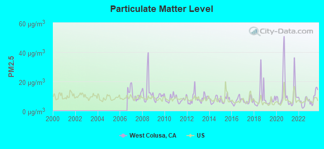
Particulate Matter (PM2.5) [µg/m3] level in 2023 was 9.51. This is about average. Closest monitor was 21.1 miles away from the city center.
| City: | 9.51 |
| U.S.: | 8.11 |
Earthquake activity:
West Colusa-area historical earthquake activity is significantly above California state average. It is 6996% greater than the overall U.S. average.On 4/18/1906 at 13:12:21, a magnitude 7.9 (7.9 UK, Class: Major, Intensity: VIII - XII) earthquake occurred 91.9 miles away from the city center, causing $524,000,000 total damage
On 1/31/1922 at 13:17:28, a magnitude 7.6 (7.6 UK) earthquake occurred 189.3 miles away from West Colusa center
On 4/25/1992 at 18:06:04, a magnitude 7.2 (6.3 MB, 7.1 MS, 7.2 MW, 7.1 MW, Depth: 9.4 mi) earthquake occurred 111.6 miles away from West Colusa center, causing $75,000,000 total damage
On 11/8/1980 at 10:27:34, a magnitude 7.2 (6.2 MB, 7.2 MS, 7.2 MW, 7.0 ML) earthquake occurred 158.6 miles away from West Colusa center
On 1/22/1923 at 09:04:18, a magnitude 7.2 (7.2 UK) earthquake occurred 171.6 miles away from the city center
On 10/18/1989 at 00:04:15, a magnitude 7.1 (6.5 MB, 7.1 MS, 6.9 MW, 7.0 ML) earthquake occurred 154.8 miles away from the city center, causing 62 deaths (62 shaking deaths) and 3757 injuries, causing $1,305,032,704 total damage
Magnitude types: body-wave magnitude (MB), local magnitude (ML), surface-wave magnitude (MS), moment magnitude (MW)
Natural disasters:
The number of natural disasters in Colusa County (16) is near the US average (15).Major Disasters (Presidential) Declared: 10
Emergencies Declared: 2
Causes of natural disasters: Floods: 12, Winter Storms: 6, Landslides: 5, Storms: 5, Mudslides: 4, Drought: 1, Freeze: 1, Heavy Rain: 1, Hurricane: 1, Tornado: 1, Other: 1 (Note: some incidents may be assigned to more than one category).
Colleges/universities with over 2000 students nearest to West Colusa:
- Mendocino College (about 40 miles; Ukiah, CA; Full-time enrollment: 2,263)
- California State University-Chico (about 48 miles; Chico, CA; FT enrollment: 14,838)
- Yuba College (about 53 miles; Marysville, CA; FT enrollment: 4,737)
- Butte College (about 53 miles; Oroville, CA; FT enrollment: 8,649)
- Santa Rosa Junior College (about 58 miles; Santa Rosa, CA; FT enrollment: 13,047)
- University of California-Davis (about 65 miles; Davis, CA; FT enrollment: 30,845)
- Sonoma State University (about 65 miles; Rohnert Park, CA; FT enrollment: 7,796)
Points of interest:
Notable locations in West Colusa: Steel Trap Rock (A), California Division of Forestry Station (B), Swifts Stone Corral (C), Little Antelope Grade (D), North Fork Campground (E), Summit Springs Trailhead (F), House Mountain (G), Black Oak Campground (H), Happy Camp (I), Cedar Camp (J), Digger Pine Campground (K), Diversion Dam Campground (L), Fouts Camp (M), Summit Springs Trailhead Parking (N), Green Flat Camp (O), Stonyford Rodeo Grounds (P), Mill Valley Campground (Q), Old Mill Campground (R), Pacific Ridge Forest Service Station (S), Stonyford Work Center (T). Display/hide their locations on the map
Churches in West Colusa include: Stonyford Community Church (A), Saint Mary of the Mountain Church (B). Display/hide their locations on the map
Cemeteries: Stonyford Cemetery (1), Pryor Grave (2). Display/hide their locations on the map
Lakes and reservoirs: Tule Pond (A), Lily Pond (B), Salt Lake (C), Upper Letts Lake (D), East Park Reservoir (E), Funks Reservoir (F). Display/hide their locations on the map
Streams, rivers, and creeks: Chamisal Creek (A), East Fork Sand Creek (B), Freshwater Branch (C), Manor Slough (D), Manzanita Creek (E), Middle Fork Stony Creek (F), Miner Creek (G), Sullivan Creek (H), Indian Creek (I). Display/hide their locations on the map
Park in West Colusa: Frenzel Creek Research Natural Area (1). Display/hide its location on the map
| This place: | 2.1 people |
| California: | 2.9 people |
| This place: | 59.5% |
| Whole state: | 68.7% |
| This place: | 5.5% |
| Whole state: | 7.2% |
Likely homosexual households (counted as self-reported same-sex unmarried-partner households)
- Lesbian couples: 0.3% of all households
- Gay men: 0.3% of all households
| This place: | 17.7% |
| Whole state: | 14.2% |
| This place: | 5.5% |
| Whole state: | 6.3% |
112 people in short-term care, detention or diagnostic centers for delinquent children in 2000
For population 15 years and over in West Colusa:
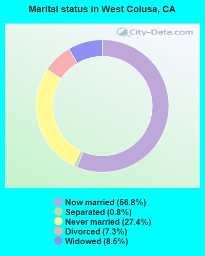
- Never married: 27.4%
- Now married: 56.8%
- Separated: 0.8%
- Widowed: 8.5%
- Divorced: 7.3%
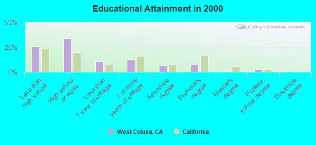
For population 25 years and over in West Colusa:
- High school or higher: 74.3%
- Bachelor's degree or higher: 10.4%
- Graduate or professional degree: 3.2%
- Unemployed: 12.5%
- Mean travel time to work (commute): 31.1 minutes
| Here: | 11.6 |
| California average: | 16.1 |
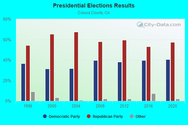
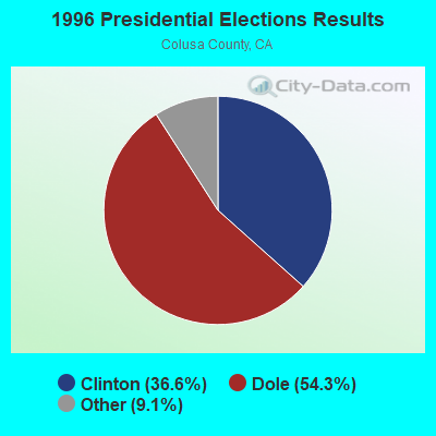
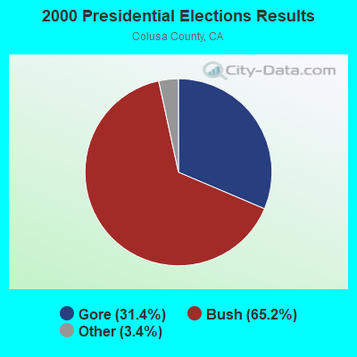
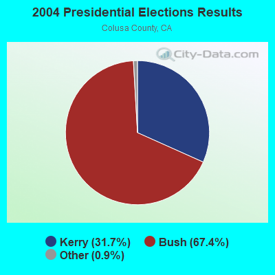
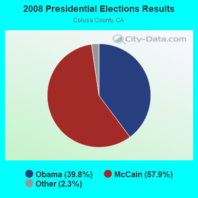
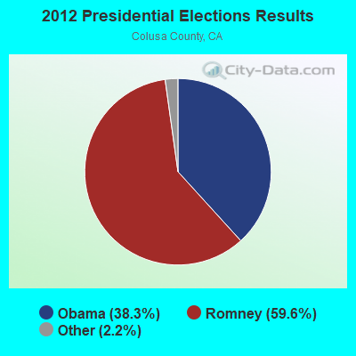
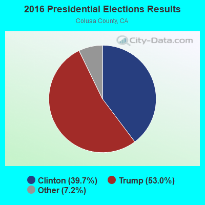

Graphs represent county-level data. Detailed 2008 Election Results
Religion statistics for West Colusa, CA (based on Colusa County data)
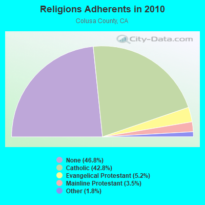
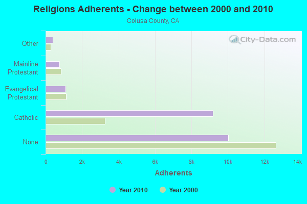
| Religion | Adherents | Congregations |
|---|---|---|
| Catholic | 9,170 | 6 |
| Evangelical Protestant | 1,106 | 13 |
| Mainline Protestant | 744 | 8 |
| Other | 379 | 2 |
| None | 10,020 | - |
Food Environment Statistics:
| Colusa County: | 4.26 / 10,000 pop. |
| California: | 2.14 / 10,000 pop. |
| This county: | 2.36 / 10,000 pop. |
| California: | 0.62 / 10,000 pop. |
| Colusa County: | 4.26 / 10,000 pop. |
| California: | 1.49 / 10,000 pop. |
| Colusa County: | 6.15 / 10,000 pop. |
| California: | 7.42 / 10,000 pop. |
| This county: | 7.8% |
| California: | 7.3% |
| Colusa County: | 24.2% |
| California: | 21.3% |
| This county: | 17.3% |
| California: | 17.9% |
Strongest AM radio stations in West Colusa:
- KCBS (740 AM; 50 kW; SAN FRANCISCO, CA; Owner: INFINITY BROADCASTING OPERATIONS, INC.)
- KFBK (1530 AM; 50 kW; SACRAMENTO, CA; Owner: AMFM RADIO LICENSES, L.L.C.)
- KFIA (710 AM; 25 kW; CARMICHAEL, CA; Owner: VISTA BROADCASTING INC.)
- KTRB (860 AM; 50 kW; MODESTO, CA; Owner: PAPPAS RADIO OF CALIFORNIA, A CALIFORNIA LIMITED PARTNERSHIP)
- KHTK (1140 AM; 50 kW; SACRAMENTO, CA; Owner: INFINITY RADIO SUBSIDIARY OPERATIONS INC.)
- KSTE (650 AM; 25 kW; RANCHO CORDOVA, CA; Owner: AMFM RADIO LICENSES, L.L.C.)
- KNBR (680 AM; 50 kW; SAN FRANCISCO, CA; Owner: KNBR LICO, INC.)
- KGO (810 AM; 50 kW; SAN FRANCISCO, CA; Owner: KGO-AM RADIO, INC.)
- KTCT (1050 AM; 50 kW; SAN MATEO, CA; Owner: SUSQUEHANNA RADIO CORP.)
- KFAX (1100 AM; 50 kW; SAN FRANCISCO, CA; Owner: GOLDEN GATE BROADCASTING CO, INC.)
- KCBC (770 AM; 50 kW; RIVERBANK, CA; Owner: KIERTRON, INC.)
- KIQI (1010 AM; 35 kW; SAN FRANCISCO, CA; Owner: RADIO UNICA OF SAN FRANCISCO LICENSE CORP.)
- KKOH (780 AM; 50 kW; RENO, NV; Owner: CITADEL BROADCASTING COMPANY)
Strongest FM radio stations in West Colusa:
- KQPT (107.5 FM; COLUSA, CA; Owner: REGENT LICENSEE OF CHICO, INC)
- KKCY (103.1 FM; COLUSA, CA; Owner: RESULTS RADIO LICENSEE, LLC)
- KNDL (89.9 FM; ANGWIN, CA; Owner: HOWELL MOUNTAIN BROADCASTING COMPANY)
- KLVR (91.9 FM; SANTA ROSA, CA; Owner: EDUCATIONAL MEDIA FOUNDATION)
- KWNE (94.5 FM; UKIAH, CA; Owner: BROADCASTING CORP. OF MENDICINO CTY.)
- KXBX-FM (98.3 FM; LAKEPORT, CA; Owner: BICOASTAL MEDIA LLC)
- KXTS (100.9 FM; CALISTOGA, CA; Owner: SINCLAIR TELECABLE, INC.)
- KQPM (105.9 FM; UKIAH, CA; Owner: BICOASTAL MEDIA LLC)
- K296ES (107.1 FM; LAKEPORT, CA; Owner: MOON BROADCASTING UKIAH, LLC)
- KNTI (99.5 FM; LAKEPORT, CA; Owner: BICOASTAL MEDIA LLC)
- KBBF (89.1 FM; SANTA ROSA, CA; Owner: BILINGUAL B/CING. FOUNDATION, INC.)
- KRCX-FM (99.9 FM; MARYSVILLE, CA; Owner: ENTRAVISION HOLDINGS, LLC)
- KMJE (101.5 FM; GRIDLEY, CA; Owner: RESULTS RADIO LICENSEE, LLC)
- K213BZ (90.5 FM; RICHVALE, CA; Owner: FAMILY STATIONS, INC.)
- KSXY (98.7 FM; MIDDLETOWN, CA; Owner: COMMONWEALTH BROADCASTING, LLC)
- KFGY (92.9 FM; HEALDSBURG, CA; Owner: MAVERICK MEDIA OF SANTA ROSA LICENSE LLC)
- KRCB-FM (91.1 FM; SANTA ROSA, CA; Owner: RURAL CALIFORNIA BROADCASTING CORP.)
- KUKI-FM (103.3 FM; UKIAH, CA; Owner: MOON BROADCASTING UKIAH, LLC)
- KZYZ (91.5 FM; WILLITS, CA; Owner: MENDOCINO COUNTY PUBLIC BROADCASTING)
- K242AD (96.3 FM; BOONVILLE, CA; Owner: MOON BROADCASTING UKIAH, LLC)
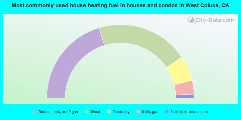
- 40.6%Bottled, tank, or LP gas
- 40.6%Wood
- 11.1%Electricity
- 6.0%Utility gas
- 1.7%Fuel oil, kerosene, etc.
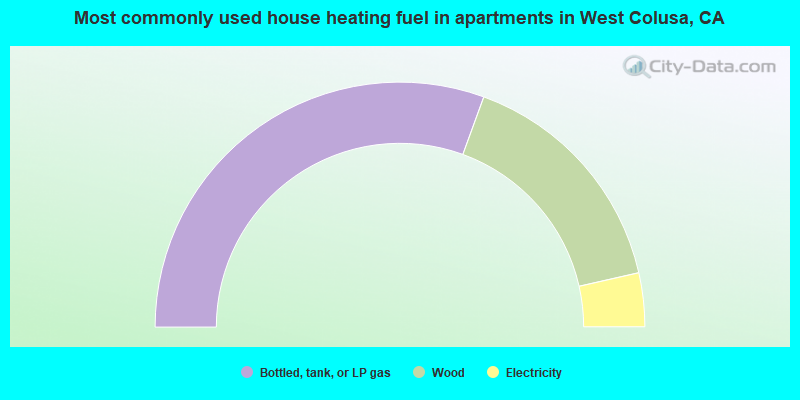
- 61.2%Bottled, tank, or LP gas
- 31.8%Wood
- 7.1%Electricity
West Colusa compared to California state average:
- Median household income below state average.
- Median house value below state average.
- Hispanic race population percentage below state average.
- Median age significantly above state average.
- Foreign-born population percentage significantly below state average.
- Renting percentage below state average.
- Length of stay since moving in significantly above state average.
- Number of rooms per house significantly below state average.
- House age significantly below state average.
- Institutionalized population percentage significantly above state average.
- Number of college students significantly below state average.
- Percentage of population with a bachelor's degree or higher significantly below state average.
West Colusa on our top lists:
- #2 on the list of "Top 101 cities with the largest percentage of people in short-term care, detention or diagnostic centers for delinquent children (population 1,000+)"