West Atoka, Oklahoma
Submit your own pictures of this place and show them to the world
- OSM Map
- General Map
- Google Map
- MSN Map

| Males: 1,807 | |
| Females: 1,773 |
| Median resident age: | 38.6 years |
| Oklahoma median age: | 35.5 years |
Zip code: 74525
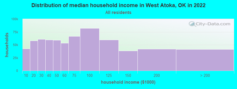
| West Atoka: | $54,561 |
| OK: | $59,673 |
Estimated per capita income in 2022: $27,002 (it was $14,052 in 2000)
West Atoka CCD income, earnings, and wages data
Estimated median house or condo value in 2022: $139,122 (it was $50,400 in 2000)
| West Atoka: | $139,122 |
| OK: | $191,700 |
Detailed information about poverty and poor residents in West Atoka, OK


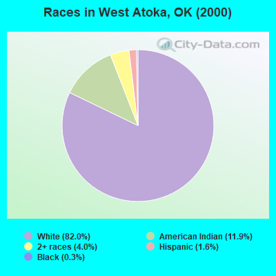
- 2,81382.0%White alone
- 40811.9%American Indian alone
- 1384.0%Two or more races
- 561.6%Hispanic
- 120.3%Black alone
- 20.06%Asian alone
Races in West Atoka detailed stats: ancestries, foreign born residents, place of birth
 Recent articles from our blog. Our writers, many of them Ph.D. graduates or candidates, create easy-to-read articles on a wide variety of topics.
Current Local Time: CST time zone
Land area: 251.7 square miles.
Population density: 14 people per square mile (very low).

| West Atoka CCD: | 0.5% ($259) |
| Oklahoma: | 0.8% ($523) |
Nearest city with pop. 50,000+: East Grayson, TX (48.9 miles  , pop. 81,381).
Nearest city with pop. 200,000+: Plano, TX (90.6 miles , pop. 222,030).
Nearest city with pop. 1,000,000+: Dallas, TX (107.9 miles , pop. 1,188,580).
Nearest cities:
), ), )Latitude: 34.29 N, Longitude: 96.25 W
Area code commonly used in this area: 580

| Here: | 3.8% |
| Oklahoma: | 3.2% |
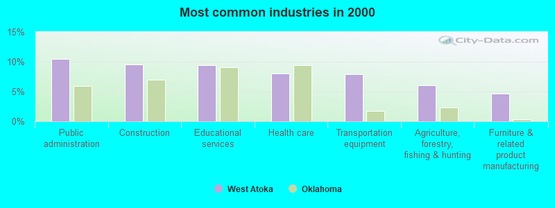
- Public administration (10.5%)
- Construction (9.5%)
- Educational services (9.5%)
- Health care (8.0%)
- Transportation equipment (7.9%)
- Agriculture, forestry, fishing & hunting (6.1%)
- Furniture & related product manufacturing (4.6%)
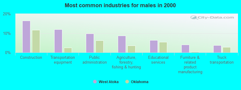
- Construction (16.5%)
- Transportation equipment (11.9%)
- Public administration (9.8%)
- Agriculture, forestry, fishing & hunting (8.7%)
- Educational services (6.4%)
- Furniture & related product manufacturing (4.1%)
- Truck transportation (3.7%)
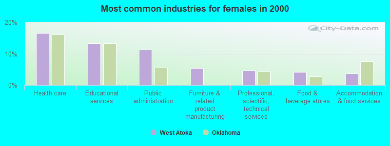
- Health care (16.5%)
- Educational services (13.3%)
- Public administration (11.3%)
- Furniture & related product manufacturing (5.4%)
- Professional, scientific, technical services (4.6%)
- Food & beverage stores (4.1%)
- Accommodation & food services (3.7%)
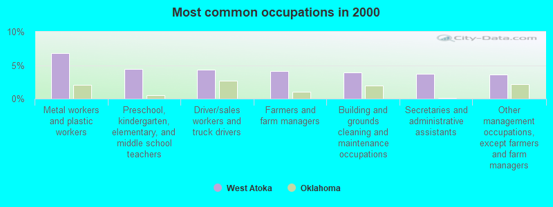
- Metal workers and plastic workers (6.8%)
- Preschool, kindergarten, elementary, and middle school teachers (4.4%)
- Driver/sales workers and truck drivers (4.3%)
- Farmers and farm managers (4.1%)
- Building and grounds cleaning and maintenance occupations (3.9%)
- Secretaries and administrative assistants (3.7%)
- Other management occupations, except farmers and farm managers (3.6%)
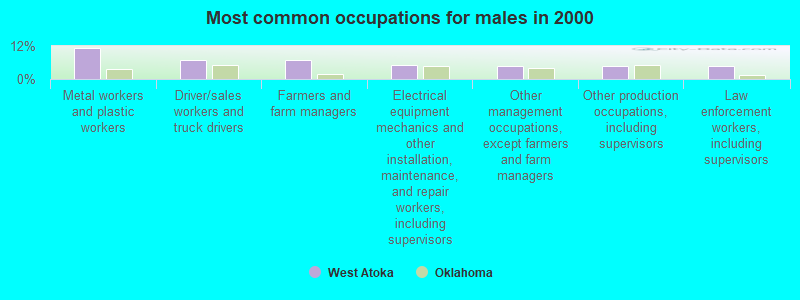
- Metal workers and plastic workers (11.3%)
- Driver/sales workers and truck drivers (7.0%)
- Farmers and farm managers (6.9%)
- Electrical equipment mechanics and other installation, maintenance, and repair workers, including supervisors (4.9%)
- Other management occupations, except farmers and farm managers (4.8%)
- Other production occupations, including supervisors (4.7%)
- Law enforcement workers, including supervisors (4.7%)

- Secretaries and administrative assistants (8.3%)
- Textile, apparel, and furnishings workers (8.0%)
- Preschool, kindergarten, elementary, and middle school teachers (6.9%)
- Other office and administrative support workers, including supervisors (6.3%)
- Cashiers (4.4%)
- Health technologists and technicians (4.3%)
- Other sales and related occupations, including supervisors (4.3%)
Average climate in West Atoka, Oklahoma
Based on data reported by over 4,000 weather stations


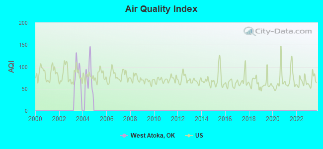
Tornado activity:
West Atoka-area historical tornado activity is near Oklahoma state average. It is 136% greater than the overall U.S. average.
On 4/27/1966, a category F4 (max. wind speeds 207-260 mph) tornado 7.0 miles away from the West Atoka place center injured 2 people and caused between $50,000 and $500,000 in damages.
On 4/2/1957, a category F4 tornado 19.5 miles away from the place center killed 3 people and injured 3 people and caused between $50,000 and $500,000 in damages.
Earthquake activity:
West Atoka-area historical earthquake activity is significantly above Oklahoma state average. It is 643% greater than the overall U.S. average.On 11/6/2011 at 03:53:10, a magnitude 5.7 (5.7 MW, Depth: 3.2 mi, Class: Moderate, Intensity: VI - VII) earthquake occurred 90.5 miles away from the city center
On 9/3/2016 at 12:02:44, a magnitude 5.8 (5.8 MW, Depth: 3.5 mi) earthquake occurred 152.3 miles away from the city center
On 11/7/2016 at 01:44:24, a magnitude 5.0 (5.0 MW, Depth: 2.8 mi) earthquake occurred 121.4 miles away from West Atoka center
On 11/8/2011 at 02:46:57, a magnitude 4.8 (4.8 MW, Depth: 3.1 mi, Class: Light, Intensity: IV - V) earthquake occurred 90.8 miles away from West Atoka center
On 11/5/2011 at 07:12:45, a magnitude 4.8 (4.8 MW, Depth: 1.9 mi) earthquake occurred 91.6 miles away from West Atoka center
On 9/6/1997 at 23:38:00, a magnitude 4.5 (4.5 LG, 4.2 LG, Depth: 3.1 mi) earthquake occurred 27.4 miles away from West Atoka center
Magnitude types: regional Lg-wave magnitude (LG), moment magnitude (MW)
Natural disasters:
The number of natural disasters in Atoka County (23) is greater than the US average (15).Major Disasters (Presidential) Declared: 15
Emergencies Declared: 6
Causes of natural disasters: Storms: 14, Floods: 12, Tornadoes: 11, Winter Storms: 6, Winds: 3, Heavy Rain: 1, Hurricane: 1, Snow: 1, Other: 1 (Note: some incidents may be assigned to more than one category).
Hospitals and medical centers near West Atoka:
- ATOKA MANOR (Nursing Home, about 9 miles away; ATOKA, OK)
- ATOKA CARE CENTER (Nursing Home, about 9 miles away; ATOKA, OK)
- COLONIAL LIVING CENTER (Nursing Home, about 9 miles away; ATOKA, OK)
- ATOKA COUNTY MEDICAL CENTER Critical Access Hospitals (about 10 miles away; ATOKA, OK)
- HOMETOWN HOSPICE (Hospital, about 10 miles away; ATOKA, OK)
- PLANTATION MANOR INC (Nursing Home, about 10 miles away; ATOKA, OK)
- CADDO NURSING HOME (Nursing Home, about 12 miles away; CADDO, OK)
Colleges/universities with over 2000 students nearest to West Atoka:
- Southeastern Oklahoma State University (about 22 miles; Durant, OK; Full-time enrollment: 3,365)
- East Central University (about 41 miles; Ada, OK; FT enrollment: 4,030)
- Grayson College (about 47 miles; Denison, TX; FT enrollment: 2,496)
- Paris Junior College (about 61 miles; Paris, TX; FT enrollment: 3,875)
- North Central Texas College (about 71 miles; Gainesville, TX; FT enrollment: 6,550)
- Texas A & M University-Commerce (about 76 miles; Commerce, TX; FT enrollment: 8,890)
- Collin County Community College District (about 82 miles; McKinney, TX; FT enrollment: 18,044)
Points of interest:
Notable locations in West Atoka: Boggy Depot (A), Wilson Community Volunteer Fire Department (B), Hopewell Community Firefighters Association (C), Caney Volunteer Fire Department (D), Wards Chapel Fire Department (E). Display/hide their locations on the map
Churches in West Atoka include: Center Hill Church (A), Pleasant View Church (B), Voca Church (C), Wards Chapel (D), Wilson Church (E), Mount Carmel Church (F). Display/hide their locations on the map
Cemeteries: Valley View Cemetery (1), Wards Chapel Cemetery (2), Whitehall Cemetery (3), Folsom Cemetery (4), High Hill Cemetery (5), Boggy Depot Cemetery (6), Indian Cemetery (7). Display/hide their locations on the map
Lakes and reservoirs: Lain Lake (A), Grassy Lake (B), Flag Lake (C), Caney Creek Site 14 Reservoir (D), Caney Creek Site 13 Reservoir (E), Caney Creek Site 12 Reservoir (F), Caney Creek Site 11 Reservoir (G), Caney Creek Site 9 Reservoir (H). Display/hide their locations on the map
Streams, rivers, and creeks: Davis Creek (A), Buffalo Creek (B), Watson Creek (C), Walnut Branch (D), Cowpen Creek (E), Big Slough (F), Big Branch (G), Cooper Creek (H), Salt Creek (I). Display/hide their locations on the map
Park in West Atoka: Boggy Depot Recreation Area (1). Display/hide its location on the map
| This place: | 2.5 people |
| Oklahoma: | 2.5 people |
| This place: | 72.7% |
| Whole state: | 66.8% |
| This place: | 5.4% |
| Whole state: | 5.9% |
Likely homosexual households (counted as self-reported same-sex unmarried-partner households)
- Lesbian couples: 0.6% of all households
- Gay men: 0.8% of all households
| This place: | 15.7% |
| Whole state: | 14.7% |
| This place: | 7.2% |
| Whole state: | 6.1% |
For population 15 years and over in West Atoka:
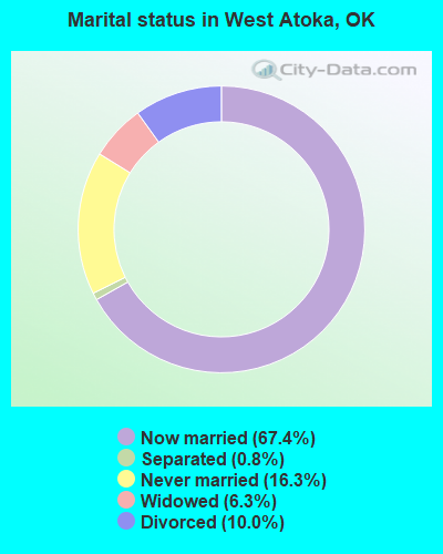
- Never married: 16.3%
- Now married: 67.4%
- Separated: 0.8%
- Widowed: 6.3%
- Divorced: 10.0%
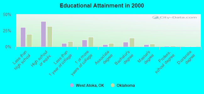
For population 25 years and over in West Atoka:
- High school or higher: 70.0%
- Bachelor's degree or higher: 11.6%
- Graduate or professional degree: 4.4%
- Unemployed: 5.4%
- Mean travel time to work (commute): 27.3 minutes
| Here: | 12.2 |
| Oklahoma average: | 11.7 |
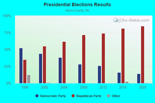
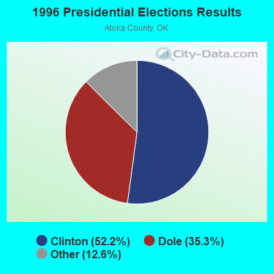
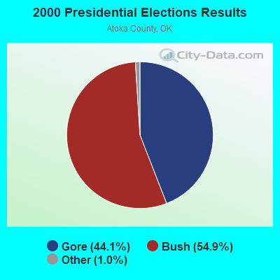
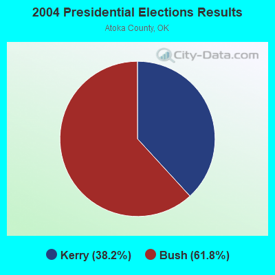
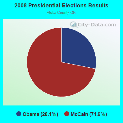
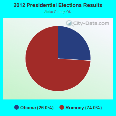
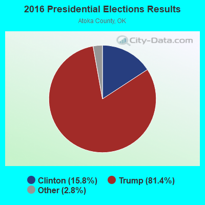
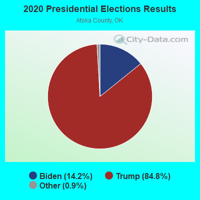
Graphs represent county-level data. Detailed 2008 Election Results
Religion statistics for West Atoka, OK (based on Atoka County data)
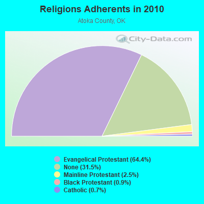
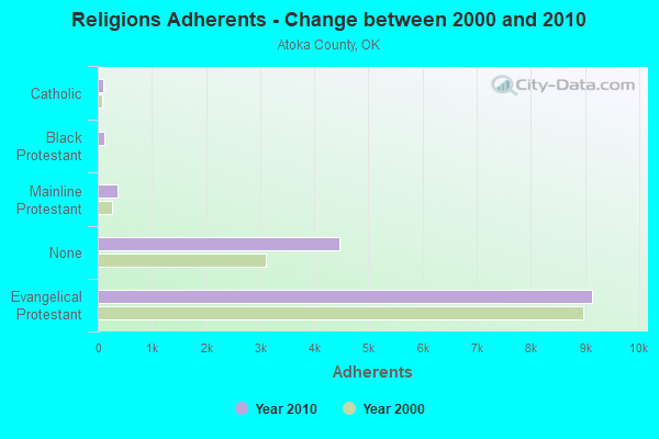
| Religion | Adherents | Congregations |
|---|---|---|
| Evangelical Protestant | 9,137 | 47 |
| Mainline Protestant | 358 | 4 |
| Black Protestant | 122 | 1 |
| Catholic | 100 | 1 |
| Other | 1 | 1 |
| None | 4,464 | - |
Food Environment Statistics:
| Atoka County: | 4.83 / 10,000 pop. |
| Oklahoma: | 1.97 / 10,000 pop. |
| Atoka County: | 0.69 / 10,000 pop. |
| Oklahoma: | 0.76 / 10,000 pop. |
| Atoka County: | 5.53 / 10,000 pop. |
| Oklahoma: | 4.35 / 10,000 pop. |
| This county: | 10.36 / 10,000 pop. |
| Oklahoma: | 6.89 / 10,000 pop. |
| This county: | 11.3% |
| State: | 10.3% |
| Atoka County: | 31.1% |
| Oklahoma: | 29.2% |
Strongest AM radio stations in West Atoka:
- KEOR (1110 AM; daytime; 5 kW; ATOKA, OK; Owner: DALLAS AM RADIO PARTNERS, L.P.)
- KYNG (950 AM; 10 kW; DENISON-SHERMAN, TX; Owner: KRBE LICO, INC.)
- KRLD (1080 AM; 50 kW; DALLAS, TX; Owner: TEXAS INFINITY BROADCASTING L.P.)
- KFXR (1190 AM; 50 kW; DALLAS, TX; Owner: CLEAR CHANNEL BROADCASTING LICENSES, INC.)
- KRMG (740 AM; 50 kW; TULSA, OK; Owner: CXR HOLDINGS, INC.)
- WBAP (820 AM; 50 kW; FORT WORTH, TX; Owner: WBAP-KSCS OPERATING, LTD.)
- KOMA (1520 AM; 50 kW; OKLAHOMA CITY, OK; Owner: RENDA BROADCASTING CORP. OF NEVADA)
- KTBK (1700 AM; 10 kW; SHERMAN, TX; Owner: KRBE LICO, INC.)
- KESS (1270 AM; 50 kW; FORT WORTH, TX; Owner: KESS-AM LICENSE CORP.)
- KZMP (1540 AM; 50 kW; UNIVERSITY PARK, TX; Owner: ENTRAVISION HOLDINGS, LLC)
- KFAQ (1170 AM; 50 kW; TULSA, OK; Owner: JOURNAL BROADCAST CORPORATION)
- KAHZ (1360 AM; 50 kW; HURST, TX)
- KSKY (660 AM; 20 kW; BALCH SPRINGS, TX; Owner: BISON MEDIA, INC.)
Strongest FM radio stations in West Atoka:
- KHKC-FM (102.1 FM; ATOKA, OK; Owner: KEYSTONE BROADCASTING CORPORATION)
- KAZC (88.3 FM; TISHOMINGO, OK; Owner: SOUTH CENTRAL OKLAHOMA CHRISTIAN BROADCASTING, INC.)
- KLBC (106.3 FM; DURANT, OK; Owner: TEXOMA BROADCASTING, INC.)
- KTCY (104.9 FM; PILOT POINT, TX; Owner: ENTRAVISION HOLDINGS, LLC)
- KKFC (105.5 FM; COALGATE, OK; Owner: WOODSTONE BROADCASTING, INC.)
- KMAD-FM (102.5 FM; WHITESBORO, TX; Owner: NM LICENSING, LLC)
- KSSU (91.9 FM; DURANT, OK; Owner: SOUTHEASTERN OKLAHOMA STATE UNIVERSITY)
- K219CX (91.7 FM; ATOKA, OK; Owner: AMERICAN FAMILY ASSOCIATION)
TV broadcast stations around West Atoka:
- KTEN (Channel 10; ADA, OK; Owner: CHANNEL 49 ACQUISITION CORPORATION)
- KXII (Channel 12; SHERMAN, TX; Owner: KXII LICENSEE CORP.)
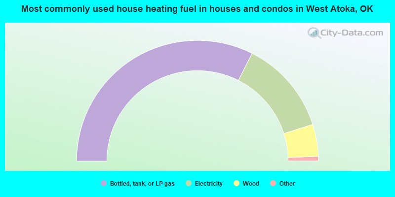
- 65.0%Bottled, tank, or LP gas
- 25.3%Electricity
- 8.6%Wood
- 0.7%Utility gas
- 0.4%Fuel oil, kerosene, etc.
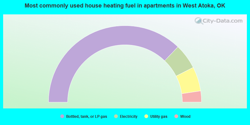
- 74.3%Bottled, tank, or LP gas
- 10.7%Electricity
- 10.3%Utility gas
- 4.7%Wood
West Atoka compared to Oklahoma state average:
- Unemployed percentage below state average.
- Black race population percentage significantly below state average.
- Hispanic race population percentage significantly below state average.
- Foreign-born population percentage significantly below state average.
- Renting percentage below state average.
- Length of stay since moving in significantly above state average.
- Number of rooms per house significantly below state average.
- House age significantly below state average.
- Number of college students below state average.
- Percentage of population with a bachelor's degree or higher below state average.
State forum archive: