Walker River, Nevada
Submit your own pictures of this place and show them to the world
- OSM Map
- General Map
- Google Map
- MSN Map

| Males: 427 | |
| Females: 388 |
| Median resident age: | 29.9 years |
| Nevada median age: | 35.0 years |
Zip code: 89427
| Walker River: | $35,779 |
| NV: | $72,333 |
Estimated per capita income in 2022: $16,246 (it was $10,265 in 2000)
Walker River CCD income, earnings, and wages data
Estimated median house or condo value in 2022: $201,463 (it was $62,000 in 2000)
| Walker River: | $201,463 |
| NV: | $434,700 |
Mean prices in 2022: all housing units: $173,936; detached houses: $171,678; mobile homes: $191,079
Detailed information about poverty and poor residents in Walker River, NV


- 61371.4%American Indian alone
- 11313.2%White alone
- 859.9%Hispanic
- 293.4%Two or more races
- 172.0%Black alone
- 10.1%Asian alone
- 10.1%Native Hawaiian and Other
Pacific Islander alone

Races in Walker River detailed stats: ancestries, foreign born residents, place of birth
 Recent articles from our blog. Our writers, many of them Ph.D. graduates or candidates, create easy-to-read articles on a wide variety of topics.
Current Local Time: PST time zone
Land area: 1169.3 square miles.
Population density: 0.7 people per square mile (very low).

| Walker River CCD: | 0.5% ($326) |
| Nevada: | 0.9% ($1,187) |
Nearest city with pop. 50,000+: Carson City, NV  (63.4 miles , pop. 52,457).
Nearest city with pop. 200,000+: Sacramento, CA (156.5 miles , pop. 407,018).
Nearest city with pop. 1,000,000+: Los Angeles, CA (335.7 miles , pop. 3,694,820).
Nearest cities:
), ), ), Latitude: 38.94 N, Longitude: 118.61 W
Area code commonly used in this area: 775


| Here: | 4.9% |
| Nevada: | 5.0% |

- Public administration (20.6%)
- Health care (13.2%)
- Construction (10.3%)
- Educational services (9.2%)
- Accommodation & food services (5.9%)
- Food & beverage stores (4.8%)
- Agriculture, forestry, fishing & hunting (4.4%)

- Public administration (26.7%)
- Construction (17.6%)
- Agriculture, forestry, fishing & hunting (9.2%)
- Educational services (5.3%)
- Accommodation & food services (5.3%)
- Health care (4.6%)
- Food & beverage stores (3.8%)

- Health care (21.3%)
- Public administration (14.9%)
- Educational services (12.8%)
- Social assistance (6.4%)
- Accommodation & food services (6.4%)
- Metal & metal products (5.7%)
- Food & beverage stores (5.7%)

- Material recording, scheduling, dispatching, and distributing workers (5.1%)
- Cashiers (4.8%)
- Other management occupations, except farmers and farm managers (4.8%)
- Cooks and food preparation workers (4.0%)
- Construction laborers (4.0%)
- Secretaries and administrative assistants (4.0%)
- Agricultural workers, including supervisors (4.0%)

- Agricultural workers, including supervisors (8.4%)
- Construction laborers (8.4%)
- Plant and system operators (6.1%)
- Construction traders workers except carpenters, electricians, painters, plumbers, and construction laborers (4.6%)
- Counselors, social workers, and other community and social service specialists (4.6%)
- Other management occupations, except farmers and farm managers (4.6%)
- Material recording, scheduling, dispatching, and distributing workers (4.6%)

- Cashiers (9.2%)
- Secretaries and administrative assistants (7.8%)
- Preschool, kindergarten, elementary, and middle school teachers (7.1%)
- Other office and administrative support workers, including supervisors (6.4%)
- Financial clerks, except bookkeeping, accounting and auditing clerks (5.7%)
- Material recording, scheduling, dispatching, and distributing workers (5.7%)
- Other management occupations, except farmers and farm managers (5.0%)
Average climate in Walker River, Nevada
Based on data reported by over 4,000 weather stations


(lower is better)

Air Quality Index (AQI) level in 2011 was 58.8. This is better than average.
| City: | 58.8 |
| U.S.: | 72.6 |

Particulate Matter (PM10) [µg/m3] level in 2011 was 18.4. This is about average. Closest monitor was 11.1 miles away from the city center.
| City: | 18.4 |
| U.S.: | 19.2 |
Earthquake activity:
Walker River-area historical earthquake activity is significantly above Nevada state average. It is 7149% greater than the overall U.S. average.Natural disasters:
The number of natural disasters in Mineral County (5) is a lot smaller than the US average (15).Major Disasters (Presidential) Declared: 1
Emergencies Declared: 3
Causes of natural disasters: Snows: 2, Flood: 1, Hurricane: 1, Storm: 1, Other: 1 (Note: some incidents may be assigned to more than one category).
Colleges/universities with over 2000 students nearest to Walker River:
- Western Nevada College (about 66 miles; Carson City, NV; Full-time enrollment: 2,338)
- Truckee Meadows Community College (about 78 miles; Reno, NV; FT enrollment: 6,919)
- University of Nevada-Reno (about 78 miles; Reno, NV; FT enrollment: 15,092)
- Folsom Lake College (about 137 miles; Folsom, CA; FT enrollment: 5,308)
- Sierra College (about 141 miles; Rocklin, CA; FT enrollment: 11,488)
- University of California-Merced (about 147 miles; Merced, CA; FT enrollment: 5,981)
- American River College (about 149 miles; Sacramento, CA; FT enrollment: 20,452)
Points of interest:
Notable locations in Walker River: Perry Buckeye Extension Fence (A), Reese River Fence (B), Black Mountain Dead Man Drift Fence (C), Lake Peak (D), Sargent Well Spring Holding Corral (E), Deadhorse Wells (F), Four Mile Fence (G), Gillis Camp (H), Nevada Scheelite Camp (I), Nevada Scheelite Mill (J), Lorena (K), Mud Windmill (L), National Mill (M), Gabbs Valley Ranch (N), Car Frame Windmill (O), Walker River - Schurz Fire Department (P). Display/hide their locations on the map
Cemetery: Rawhide Cemetery (1). Display/hide its location on the map
Reservoir: Weber Reservoir (A). Display/hide its location on the map
Streams, rivers, and creeks: Nugent Wash (A), Walker River (B), Finger Rock Wash (C), Phillips Wash (D), Wovoka Wash (E), Hu-Pwi Wash (F), Hidden Wash (G), Eagle Wash (H). Display/hide their locations on the map
| This place: | 2.4 people |
| Nevada: | 2.6 people |
| This place: | 61.9% |
| Whole state: | 65.3% |
| This place: | 11.9% |
| Whole state: | 8.7% |
Likely homosexual households (counted as self-reported same-sex unmarried-partner households)
- Lesbian couples: 0.0% of all households
- Gay men: 0.3% of all households
| This place: | 31.9% |
| Whole state: | 10.5% |
| This place: | 17.1% |
| Whole state: | 4.9% |
For population 15 years and over in Walker River:

- Never married: 30.5%
- Now married: 43.7%
- Separated: 1.3%
- Widowed: 7.1%
- Divorced: 18.8%
For population 25 years and over in Walker River:
- High school or higher: 65.7%
- Bachelor's degree or higher: 5.0%
- Graduate or professional degree: 1.9%
- Unemployed: 22.1%
- Mean travel time to work (commute): 22.9 minutes


| Here: | 11.4 |
| Nevada average: | 11.9 |
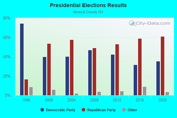
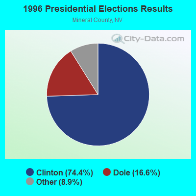
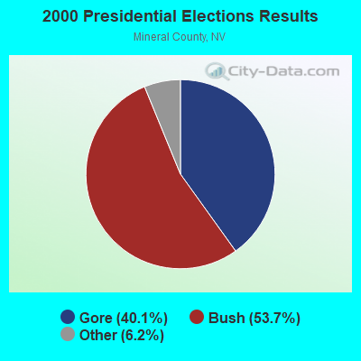
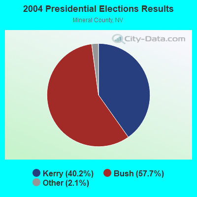
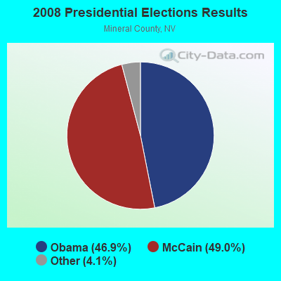
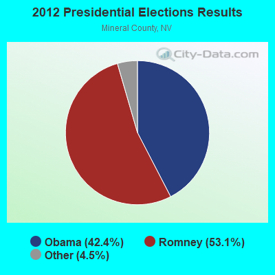
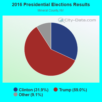
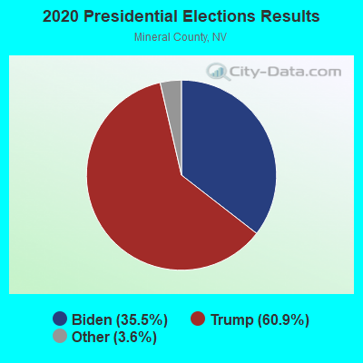
Graphs represent county-level data. Detailed 2008 Election Results
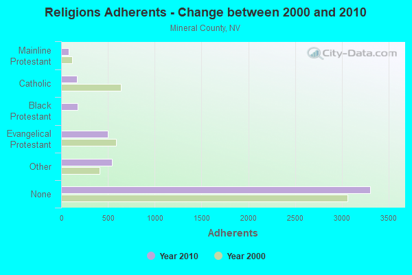
Religion statistics for Walker River, NV (based on Mineral County data)
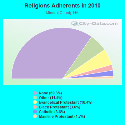
| Religion | Adherents | Congregations |
|---|---|---|
| Other | 543 | 3 |
| Evangelical Protestant | 497 | 9 |
| Black Protestant | 173 | 1 |
| Catholic | 171 | 1 |
| Mainline Protestant | 82 | 2 |
| None | 3,306 | - |
Food Environment Statistics:
| Mineral County: | 2.10 / 10,000 pop. |
| Nevada: | 1.50 / 10,000 pop. |
| Mineral County: | 8.41 / 10,000 pop. |
| Nevada: | 2.56 / 10,000 pop. |
| Here: | 4.20 / 10,000 pop. |
| State: | 6.14 / 10,000 pop. |
| This county: | 11.5% |
| Nevada: | 8.2% |
| Mineral County: | 29.8% |
| State: | 24.5% |
Strongest AM radio stations in Walker River:
- KKOH (780 AM; 50 kW; RENO, NV; Owner: CITADEL BROADCASTING COMPANY)
- KVLV (980 AM; daytime; 5 kW; FALLON, NV; Owner: LAHONTAN VALLEY BROADCASTING COMPANY, LLC)
- KMJ (580 AM; 50 kW; FRESNO, CA; Owner: INFINITY RADIO OPERATIONS INC.)
- KCBC (770 AM; 50 kW; RIVERBANK, CA; Owner: KIERTRON, INC.)
- KBZZ (1270 AM; 13 kW; SPARKS, NV; Owner: AMERICOM LAS VEGAS LIMITED PARTNERSHIP)
- KHTK (1140 AM; 50 kW; SACRAMENTO, CA; Owner: INFINITY RADIO SUBSIDIARY OPERATIONS INC.)
- KWRU (940 AM; 50 kW; FRESNO, CA)
- KSTE (650 AM; 25 kW; RANCHO CORDOVA, CA; Owner: AMFM RADIO LICENSES, L.L.C.)
- KFIA (710 AM; 25 kW; CARMICHAEL, CA; Owner: VISTA BROADCASTING INC.)
- KNBR (680 AM; 50 kW; SAN FRANCISCO, CA; Owner: KNBR LICO, INC.)
- KFBK (1530 AM; 50 kW; SACRAMENTO, CA; Owner: AMFM RADIO LICENSES, L.L.C.)
- KCBS (740 AM; 50 kW; SAN FRANCISCO, CA; Owner: INFINITY BROADCASTING OPERATIONS, INC.)
- KGO (810 AM; 50 kW; SAN FRANCISCO, CA; Owner: KGO-AM RADIO, INC.)
Strongest FM radio stations in Walker River:
- KSVL (92.3 FM; SMITH, NV; Owner: DONEGAL ENTERPRISES)
- KTHX-FM (100.1 FM; DAYTON, NV; Owner: NM LICENSING, LLC)
- KSRN (107.7 FM; KINGS BEACH, CA; Owner: NM LICENSING, LLC)
- KRNO (106.9 FM; INCLINE VILLAGE, NV; Owner: AMERICOM LAS VEGAS LIMITED PARTNERSHIP)
- KODS (103.7 FM; CARNELIAN BAY, CA; Owner: AMERICOM, A CALIFORNIA LIMITED PARTNERSHIP)
- KWYL (102.9 FM; SOUTH LAKE TAHOE, CA; Owner: CITADEL BROADCASTING COMPANY)
- KLCA (96.5 FM; TAHOE CITY, CA; Owner: AMERICOM LAS VEGAS LIMITED PARTNERSHIP)
- KKTO (90.5 FM; TAHOE CITY, CA; Owner: CALIFORNIA STATE UNIVERSITY)
- KDOT (104.5 FM; RENO, NV; Owner: LOTUS RADIO CORP.)
- KOZZ-FM (105.7 FM; RENO, NV; Owner: LOTUS RADIO CORP.)
- KNHK (92.9 FM; RENO, NV; Owner: CITADEL BROADCASTING COMPANY)
- KBUL-FM (98.1 FM; CARSON CITY, NV; Owner: CITADEL BROADCASTING COMPANY)
- KRNG (101.3 FM; FALLON, NV; Owner: SIERRA NV CHRISTIAN MUSIC ASSOC, INC)
- KNEV (95.5 FM; RENO, NV; Owner: CITADEL BROADCASTING COMPANY)
- KUNR (88.7 FM; RENO, NV; Owner: UNIVERSITY OF NEVADA, RENO)
- KNIS (91.3 FM; CARSON CITY, NV; Owner: WESTERN INSPIRATIONAL BROADCASTERS, INC)
- KWNZ (97.3 FM; CARSON CITY, NV; Owner: AMERICOM LAS VEGAS LIMITED PARTNERSHIP)
- KRNG-FM1 (101.3 FM; RENO, NV; Owner: SIERRA NV CHRISTIAN MUSIC ASSN INC)
- KSSJ (94.7 FM; FAIR OAKS, CA; Owner: ENTERCOM SACRAMENTO LICENSE, LLC)
- K273AF (102.5 FM; CARSON CITY, NV; Owner: EDDIE FLOYD)

- 55.7%Bottled, tank, or LP gas
- 27.9%Wood
- 7.0%Fuel oil, kerosene, etc.
- 4.1%Electricity
- 2.9%Other fuel
- 2.5%Utility gas

- 60.3%Bottled, tank, or LP gas
- 26.5%Wood
- 7.4%Fuel oil, kerosene, etc.
- 2.9%Utility gas
- 2.9%Electricity
Walker River compared to Nevada state average:
- Median household income below state average.
- Median house value below state average.
- Black race population percentage significantly below state average.
- Hispanic race population percentage significantly below state average.
- Median age significantly below state average.
- Foreign-born population percentage significantly below state average.
- Length of stay since moving in significantly above state average.
- Number of rooms per house significantly below state average.
- House age significantly below state average.
- Number of college students below state average.
- Percentage of population with a bachelor's degree or higher significantly below state average.