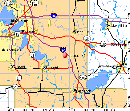
Utica, Wisconsin
Submit your own pictures of this town and show them to the world
- OSM Map
- General Map
- Google Map
- MSN Map
Population change since 2000: +11.2%
| Males: 687 | |
| Females: 612 |
| Median resident age: | 45.7 years |
| Wisconsin median age: | 42.6 years |
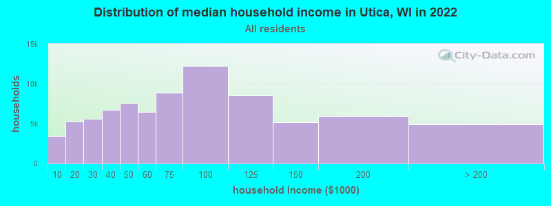
| Utica: | $77,767 |
| WI: | $70,996 |
Estimated per capita income in 2022: $38,633 (it was $21,518 in 2000)
Utica town income, earnings, and wages data
Estimated median house or condo value in 2022: $260,602 (it was $122,000 in 2000)
| Utica: | $260,602 |
| WI: | $252,800 |
Mean prices in 2022: all housing units: $258,718; detached houses: $267,193; townhouses or other attached units: $243,221; in 2-unit structures: $143,702; in 3-to-4-unit structures: $124,292; in 5-or-more-unit structures: $198,676; mobile homes: $50,547
Detailed information about poverty and poor residents in Utica, WI


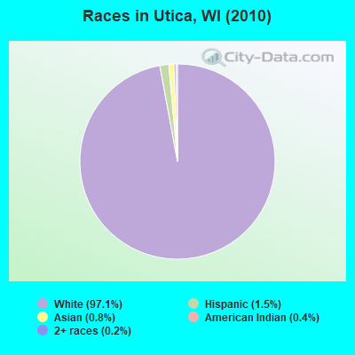
- 1,26197.1%White alone
- 191.5%Hispanic
- 100.8%Asian alone
- 50.4%American Indian alone
- 30.2%Two or more races
- 10.08%Other race alone
Races in Utica detailed stats: ancestries, foreign born residents, place of birth
 Recent articles from our blog. Our writers, many of them Ph.D. graduates or candidates, create easy-to-read articles on a wide variety of topics.

Latest news from Utica, WI collected exclusively by city-data.com from local newspapers, TV, and radio stations
Ancestries: German (59.8%), English (12.8%), Irish (11.9%), Polish (6.8%), Welsh (5.1%), Norwegian (4.6%).
Current Local Time: CST time zone
Land area: 35.9 square miles.
Population density: 36 people per square mile (very low).
8 residents are foreign born
| This town: | 0.7% |
| Wisconsin: | 3.6% |
| Utica town: | 1.5% ($1,890) |
| Wisconsin: | 2.0% ($2,245) |
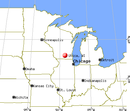
Nearest city with pop. 50,000+: Oshkosh, WI  (9.2 miles , pop. 62,916).
Nearest city with pop. 200,000+: Madison, WI (69.6 miles , pop. 208,054).
Nearest city with pop. 1,000,000+: Chicago, IL (154.5 miles , pop. 2,896,016).
Nearest cities:
), ), ), ), Latitude: 43.95 N, Longitude: 88.70 W
Area code commonly used in this area: 920

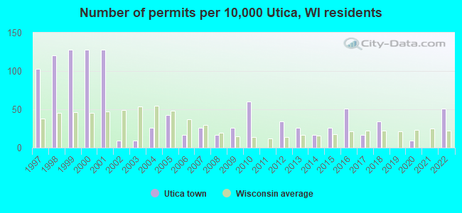
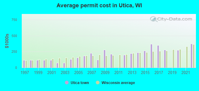
Single-family new house construction building permits:
- 2022: 6 buildings, average cost: $374,800
- 2020: 1 building, cost: $275,000
- 2018: 4 buildings, average cost: $279,500
- 2017: 2 buildings, average cost: $350,000
- 2016: 6 buildings, average cost: $371,700
- 2015: 3 buildings, average cost: $266,700
- 2014: 2 buildings, average cost: $240,000
- 2013: 3 buildings, average cost: $223,300
- 2012: 4 buildings, average cost: $197,500
- 2010: 7 buildings, average cost: $212,400
- 2009: 3 buildings, average cost: $279,000
- 2008: 2 buildings, average cost: $125,000
- 2007: 3 buildings, average cost: $226,700
- 2006: 2 buildings, average cost: $183,900
- 2005: 5 buildings, average cost: $156,300
- 2004: 3 buildings, average cost: $133,500
- 2003: 1 building, cost: $75,000
- 2002: 1 building, cost: $75,000
- 2001: 15 buildings, average cost: $118,200
- 2000: 15 buildings, average cost: $118,200
- 1999: 15 buildings, average cost: $118,200
- 1998: 14 buildings, average cost: $118,200
- 1997: 12 buildings, average cost: $118,200
| Here: | 2.3% |
| Wisconsin: | 2.7% |
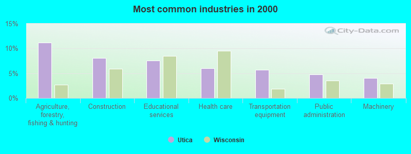
- Agriculture, forestry, fishing & hunting (11.1%)
- Construction (8.0%)
- Educational services (7.6%)
- Health care (6.0%)
- Transportation equipment (5.7%)
- Public administration (4.8%)
- Machinery (4.0%)
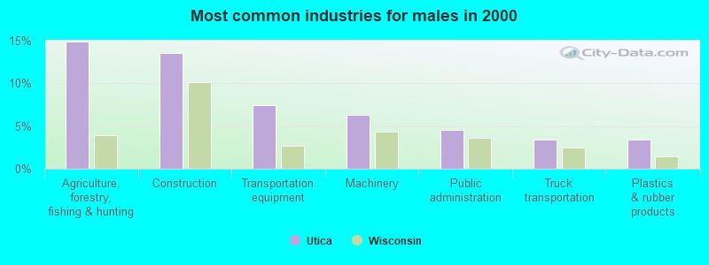
- Agriculture, forestry, fishing & hunting (14.9%)
- Construction (13.5%)
- Transportation equipment (7.5%)
- Machinery (6.3%)
- Public administration (4.6%)
- Truck transportation (3.4%)
- Plastics & rubber products (3.4%)
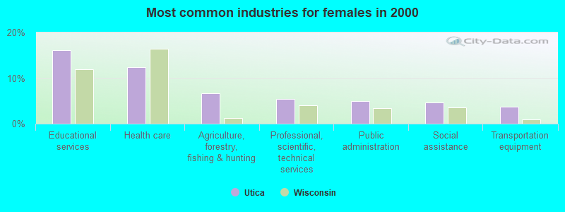
- Educational services (16.1%)
- Health care (12.4%)
- Agriculture, forestry, fishing & hunting (6.7%)
- Professional, scientific, technical services (5.4%)
- Public administration (5.0%)
- Social assistance (4.7%)
- Transportation equipment (3.7%)
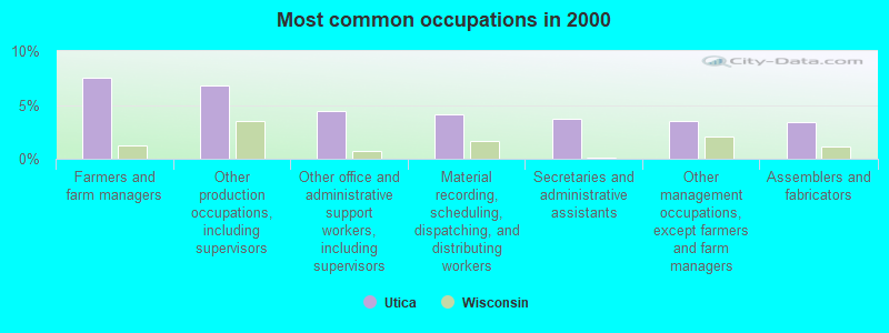
- Farmers and farm managers (7.6%)
- Other production occupations, including supervisors (6.8%)
- Other office and administrative support workers, including supervisors (4.5%)
- Material recording, scheduling, dispatching, and distributing workers (4.2%)
- Secretaries and administrative assistants (3.7%)
- Other management occupations, except farmers and farm managers (3.6%)
- Assemblers and fabricators (3.4%)
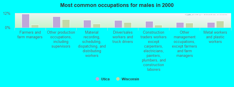
- Farmers and farm managers (11.5%)
- Other production occupations, including supervisors (9.2%)
- Material recording, scheduling, dispatching, and distributing workers (6.3%)
- Driver/sales workers and truck drivers (6.0%)
- Construction traders workers except carpenters, electricians, painters, plumbers, and construction laborers (5.5%)
- Other management occupations, except farmers and farm managers (4.3%)
- Metal workers and plastic workers (4.3%)

- Secretaries and administrative assistants (7.4%)
- Preschool, kindergarten, elementary, and middle school teachers (7.0%)
- Other office and administrative support workers, including supervisors (6.4%)
- Registered nurses (6.0%)
- Assemblers and fabricators (5.0%)
- Other production occupations, including supervisors (4.0%)
- Other teachers, instructors, education, training, and library occupations (4.0%)
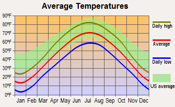
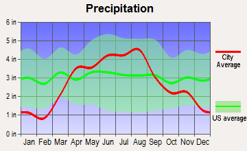
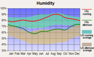
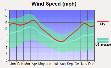
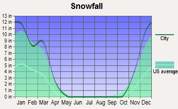
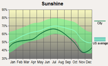
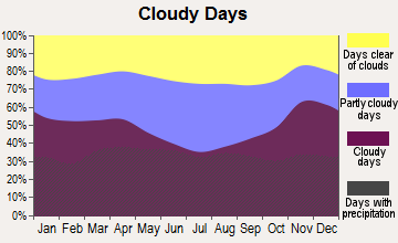
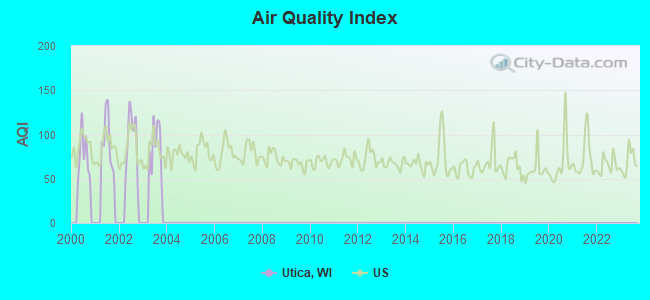
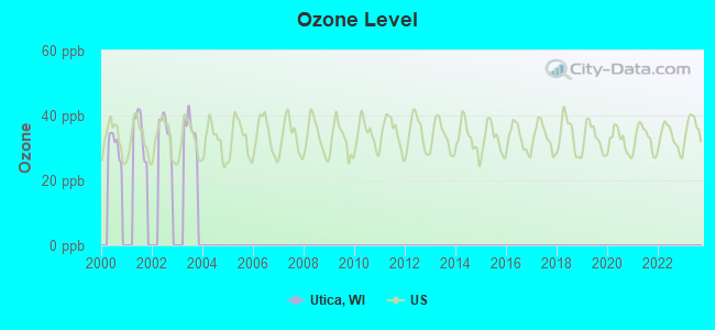
Average climate in Utica, Wisconsin
Based on data reported by over 4,000 weather stations
Tornado activity:
Utica-area historical tornado activity is slightly above Wisconsin state average. It is 53% greater than the overall U.S. average.
On 7/18/1996, a category F5 (max. wind speeds 261-318 mph) tornado 17.5 miles away from the Utica town center injured 12 people and caused $40 million in damages.
On 4/3/1956, a category F4 (max. wind speeds 207-260 mph) tornado 7.6 miles away from the town center killed 7 people and injured 50 people and caused between $500,000 and $5,000,000 in damages.
Earthquake activity:
Utica-area historical earthquake activity is significantly above Wisconsin state average. It is 0% smaller than the overall U.S. average.On 4/18/2008 at 09:36:59, a magnitude 5.4 (5.1 MB, 4.8 MS, 5.4 MW, 5.2 MW, Class: Moderate, Intensity: VI - VII) earthquake occurred 382.3 miles away from the city center
On 6/28/2004 at 06:10:52, a magnitude 4.2 (4.2 MW, Depth: 6.2 mi, Class: Light, Intensity: IV - V) earthquake occurred 172.2 miles away from the city center
On 6/10/1987 at 23:48:54, a magnitude 5.1 (4.9 MB, 4.4 MS, 4.6 MS, 5.1 LG) earthquake occurred 357.0 miles away from the city center
On 5/2/2015 at 16:23:07, a magnitude 4.2 (4.2 MW, Depth: 2.8 mi) earthquake occurred 203.2 miles away from Utica center
On 4/18/2008 at 09:36:59, a magnitude 5.2 (5.2 MW, Depth: 8.9 mi) earthquake occurred 382.4 miles away from the city center
On 2/10/2010 at 09:59:35, a magnitude 3.8 (3.8 MW, Depth: 6.2 mi, Class: Light, Intensity: II - III) earthquake occurred 137.1 miles away from the city center
Magnitude types: regional Lg-wave magnitude (LG), body-wave magnitude (MB), surface-wave magnitude (MS), moment magnitude (MW)
Natural disasters:
The number of natural disasters in Winnebago County (9) is smaller than the US average (15).Major Disasters (Presidential) Declared: 7
Emergencies Declared: 2
Causes of natural disasters: Floods: 5, Storms: 4, Tornadoes: 4, Drought: 1, Hurricane: 1, Other: 1 (Note: some incidents may be assigned to more than one category).
Hospitals and medical centers near Utica:
- FMC DIALYSIS - OSHKOSH (Dialysis Facility, about 7 miles away; OSHKOSH, WI)
- OMRO CARE CTR (Nursing Home, about 7 miles away; OMRO, WI)
- MERCY MED CTR OF OSHKOSH Acute Care Hospitals (about 7 miles away; OSHKOSH, WI)
- MERCY MEDICAL CTR SUBACUTE (Nursing Home, about 7 miles away; OSHKOSH, WI)
- RESCARE HOME CARE WISCONSIN, INC (Home Health Center, about 8 miles away; OSHKOSH, WI)
- AURORA MED CTR OSHKOSH Acute Care Hospitals (about 8 miles away; OSHKOSH, WI)
- BETHEL HOME (Nursing Home, about 9 miles away; OSHKOSH, WI)
Colleges/universities with over 2000 students nearest to Utica:
- University of Wisconsin-Oshkosh (about 10 miles; Oshkosh, WI; Full-time enrollment: 10,637)
- Moraine Park Technical College (about 18 miles; Fond du Lac, WI; FT enrollment: 3,079)
- Marian University (about 19 miles; Fond Du Lac, WI; FT enrollment: 2,045)
- Fox Valley Technical College (about 27 miles; Appleton, WI; FT enrollment: 5,682)
- Lawrence University (about 27 miles; Appleton, WI; FT enrollment: 2,821)
- Lakeland College (about 42 miles; Plymouth, WI; FT enrollment: 2,395)
- Saint Norbert College (about 47 miles; De Pere, WI; FT enrollment: 2,324)
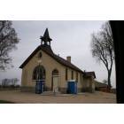
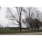
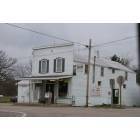
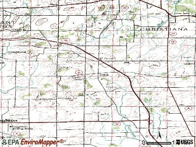
Points of interest:
Notable locations in Utica: Hilltop Acres (A), Radloff Dairy Farm (B), Fritz Farm (C), Gizmo Farm (D), Bradley Farm (E), Bradbo Farm (F), Fisher Farms (G), Maple Lane Farm (H), Utica Volunteer Fire Department and First Responders (I). Display/hide their locations on the map
Cemetery: Liberty Prairie Cemetery (1). Display/hide its location on the map
Creek: Eightmile Creek (A). Display/hide its location on the map
| This town: | 2.5 people |
| Wisconsin: | 2.4 people |
| This town: | 73.3% |
| Whole state: | 64.4% |
| This town: | 7.6% |
| Whole state: | 7.3% |
Likely homosexual households (counted as self-reported same-sex unmarried-partner households)
- Lesbian couples: 0.6% of all households
- Gay men: 0.2% of all households
| This town: | 3.8% |
| Whole state: | 8.7% |
| This town: | 1.3% |
| Whole state: | 3.7% |
For population 15 years and over in Utica:
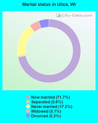
- Never married: 17.2%
- Now married: 71.7%
- Separated: 0.6%
- Widowed: 5.1%
- Divorced: 5.3%
For population 25 years and over in Utica:
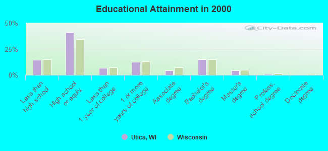
- High school or higher: 85.3%
- Bachelor's degree or higher: 20.4%
- Graduate or professional degree: 5.4%
- Unemployed: 0.9%
- Mean travel time to work (commute): 22.2 minutes
| Here: | 11.1 |
| Wisconsin average: | 11.0 |
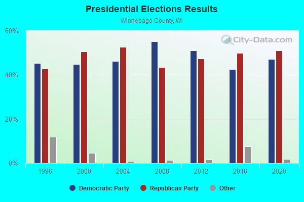
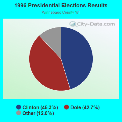
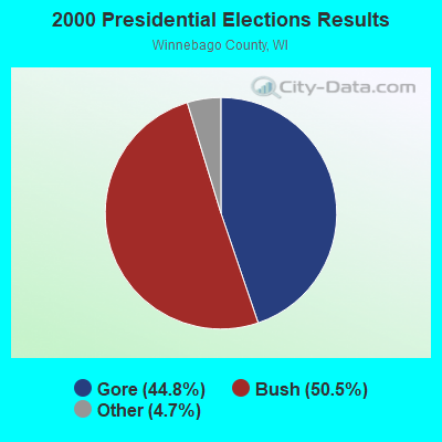
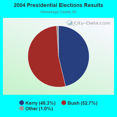
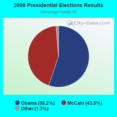
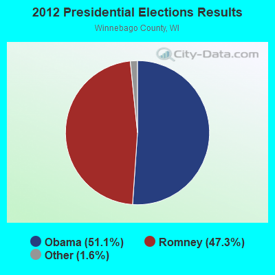
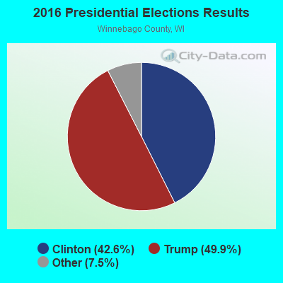
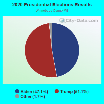
Graphs represent county-level data. Detailed 2008 Election Results
Religion statistics for Utica, WI (based on Winnebago County data)
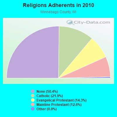
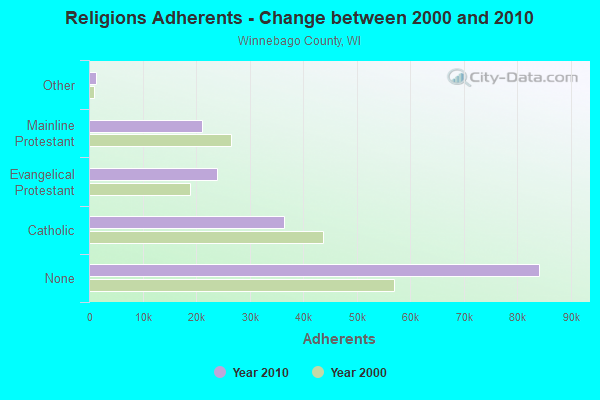
| Religion | Adherents | Congregations |
|---|---|---|
| Catholic | 36,514 | 11 |
| Evangelical Protestant | 23,938 | 66 |
| Mainline Protestant | 21,022 | 43 |
| Other | 1,359 | 10 |
| None | 84,161 | - |
Food Environment Statistics:
| This county: | 0.74 / 10,000 pop. |
| State: | 1.86 / 10,000 pop. |
| This county: | 0.06 / 10,000 pop. |
| Wisconsin: | 0.11 / 10,000 pop. |
| Winnebago County: | 0.19 / 10,000 pop. |
| State: | 0.38 / 10,000 pop. |
| Winnebago County: | 3.47 / 10,000 pop. |
| Wisconsin: | 4.12 / 10,000 pop. |
| Winnebago County: | 7.50 / 10,000 pop. |
| Wisconsin: | 8.64 / 10,000 pop. |
| Winnebago County: | 7.4% |
| Wisconsin: | 7.6% |
| Winnebago County: | 26.3% |
| Wisconsin: | 27.5% |
| This county: | 13.4% |
| State: | 13.0% |
Strongest AM radio stations in Utica:
- WNAM (1280 AM; 50 kW; NEENAH-MENASHA, WI; Owner: CUMULUS LICENSING CORP.)
- WHBY (1150 AM; 25 kW; KIMBERLY, WI; Owner: WOODWARD COMMUNICATIONS, INC.)
- WRPN (1600 AM; 5 kW; RIPON, WI)
- WSPT (1010 AM; 50 kW; STEVENS POINT, WI)
- WTMJ (620 AM; 50 kW; MILWAUKEE, WI; Owner: JOURNAL BROADCAST CORPORATION)
- WISN (1130 AM; 50 kW; MILWAUKEE, WI; Owner: CAPSTAR TX LIMITED PARTNERSHIP)
- WSAU (550 AM; 20 kW; WAUSAU, WI; Owner: WRIG, INC.)
- WOSH (1490 AM; 1 kW; OSHKOSH, WI; Owner: CUMULUS LICENSING CORP.)
- WDUX (800 AM; 5 kW; WAUPACA, WI; Owner: LAIRD BROADCASTING COMPANY, INC.)
- WTAQ (1360 AM; 10 kW; GREEN BAY, WI; Owner: MIDWEST COMMUNICATIONS, INC.)
- WGN (720 AM; 50 kW; CHICAGO, IL; Owner: WGN CONTINENTAL BROADCASTING CO.)
- WSCR (670 AM; 50 kW; CHICAGO, IL; Owner: INFINITY BROADCASTING OPERATIONS, INC.)
- WBBM (780 AM; 50 kW; CHICAGO, IL; Owner: INFINITY BROADCASTING OPERATIONS, INC.)
Strongest FM radio stations in Utica:
- WTCX (96.1 FM; RIPON, WI; Owner: RADIO B/C LTD PARTNERSHIP)
- WPKR (99.5 FM; OMRO, WI; Owner: MIDWEST DIMENSIONS, INC.)
- WVBO (103.9 FM; WINNECONNE, WI; Owner: CUMULUS LICENSING CORP.)
- WAPL-FM (105.7 FM; APPLETON, WI; Owner: WOODWARD COMMUNICATIONS, INC.)
- WBJZ (104.7 FM; BERLIN, WI; Owner: CAXAMBAS CORPORATION)
- WROE (94.3 FM; NEENAH-MENASHA, WI; Owner: MIDWEST COMMUNICATIONS, INC.)
- WWWX (96.9 FM; OSHKOSH, WI; Owner: CUMULUS LICENSING CORP.)
- W203AV (88.5 FM; OSHKOSH, WI; Owner: WRVM, INC.)
- WNCY-FM (100.3 FM; NEENAH-MENASHA, WI; Owner: MIDWEST COMMUNICATIONS, INC.)
- WRST-FM (90.3 FM; OSHKOSH, WI; Owner: BOARD OF REGENTS, UNIVERSITY OF WISCONSIN SYSTEM)
- KFIZ-FM (107.1 FM; FOND DU LAC, WI; Owner: RBH ENTERPRISES, INC.)
- WFDL-FM (97.7 FM; LOMIRA, WI; Owner: RADIO PLUS OF FOND DU LAC, INC.)
- WAUH (102.3 FM; WAUTOMA, WI; Owner: HOMETOWN BROADCASTING LLC)
- WEMI (91.9 FM; APPLETON, WI; Owner: EVANGEL MINISTRIES, INC.)
TV broadcast stations around Utica:
- WMMF-TV (Channel 68; FOND DU LAC, WI; Owner: PAPPAS TELECASTING OF WISCONSIN, A CALIFORNIA LTD PARTNRSHP)
- W23BL (Channel 23; TRAVERSE CITY, MI; Owner: MS COMMUNICATIONS, LLC)
- WWRS-TV (Channel 52; MAYVILLE, WI; Owner: NATIONAL MINORITY T.V., INC.)
- WLUK-TV (Channel 11; GREEN BAY, WI; Owner: EMMIS TELEVISION LICENSE CORPORATION)
- WFRV-TV (Channel 5; GREEN BAY, WI; Owner: CBS BROADCASTING INC.)
- WBAY-TV (Channel 2; GREEN BAY, WI; Owner: YOUNG BROADCASTING OF GREEN BAY, INC.)
- W17CF (Channel 17; RIPON, WI; Owner: TRINITY BROADCASTING NETWORK)
- WPNE (Channel 38; GREEN BAY, WI; Owner: WISCONSIN EDUCATIONAL COMMUNICATIONS BOARD)
- National Bridge Inventory (NBI) Statistics
- 5Number of bridges
- 20ft / 6.0mTotal length
- $165,000Total costs
- 360Total average daily traffic
- 387Total future (year 2039) average daily traffic
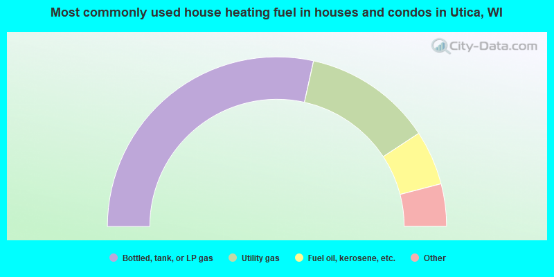
- 57.0%Bottled, tank, or LP gas
- 24.6%Utility gas
- 10.4%Fuel oil, kerosene, etc.
- 3.8%Electricity
- 2.3%Wood
- 1.0%Other fuel
- 0.5%Solar energy
- 0.5%No fuel used
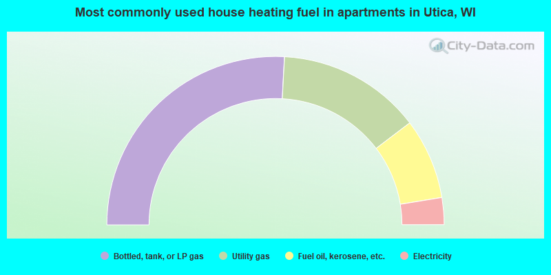
- 51.7%Bottled, tank, or LP gas
- 27.6%Utility gas
- 15.5%Fuel oil, kerosene, etc.
- 5.2%Electricity
Utica compared to Wisconsin state average:
- Unemployed percentage significantly below state average.
- Black race population percentage significantly below state average.
- Hispanic race population percentage significantly below state average.
- Foreign-born population percentage significantly below state average.
- Renting percentage significantly below state average.
- Length of stay since moving in significantly above state average.
- Number of rooms per house significantly below state average.
- House age significantly below state average.
- Number of college students below state average.