Upper Falls, West Virginia
Submit your own pictures of this place and show them to the world
- OSM Map
- Google Map
- MSN Map
| Males: 1,582 | |
| Females: 2,119 |
| Median resident age: | 42.2 years |
| West Virginia median age: | 42.9 years |
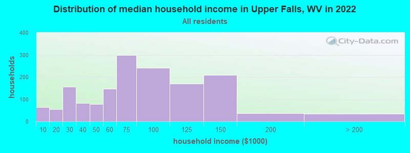
| Upper Falls: | $55,215 |
| WV: | $54,329 |
Estimated per capita income in 2022: $36,483
Upper Falls CDP income, earnings, and wages data
Estimated median house or condo value in 2022: $135,500
| Upper Falls: | $135,500 |
| WV: | $155,100 |
Mean prices in 2022: all housing units: $169,736; detached houses: $191,359; townhouses or other attached units: $114,767; mobile homes: $37,946
Median gross rent in 2022: $707.
(12.8% for White Non-Hispanic residents, 54.5% for Hispanic or Latino residents)
Detailed information about poverty and poor residents in Upper Falls, WV


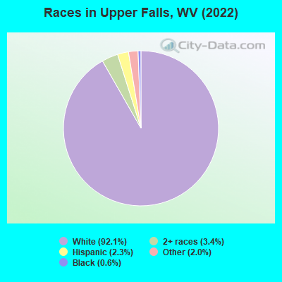
- 3,55892.1%White alone
- 1303.4%Two or more races
- 902.3%Hispanic
- 792.0%Other race alone
- 230.6%Black alone
Races in Upper Falls detailed stats: ancestries, foreign born residents, place of birth
 Recent articles from our blog. Our writers, many of them Ph.D. graduates or candidates, create easy-to-read articles on a wide variety of topics.
Ancestries: English (34.8%), American (26.5%), German (11.7%), Irish (8.1%), Scottish (3.0%), Italian (1.8%).
Current Local Time: EST time zone
Elevation: 610 feet
42 residents are foreign born
| This place: | 1.1% |
| West Virginia: | 100.0% |
Median real estate property taxes paid for housing units with mortgages in 2022: $1,118 (0.6%)
Median real estate property taxes paid for housing units with no mortgage in 2022: $699 (0.6%)
Nearest city with pop. 50,000+: Charleston, WV  (11.5 miles , pop. 53,421).
Nearest city with pop. 200,000+: Columbus, OH (129.5 miles , pop. 711,470).
Nearest city with pop. 1,000,000+: Philadelphia, PA (376.9 miles , pop. 1,517,550).
Nearest cities:
), ), ), Latitude: 38.34 N, Longitude: 81.84 W
| Here: | 3.7% |
| West Virginia: | 4.0% |
(lower is better)
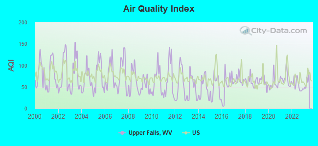
Air Quality Index (AQI) level in 2022 was 54.5. This is better than average.
| City: | 54.5 |
| U.S.: | 72.6 |
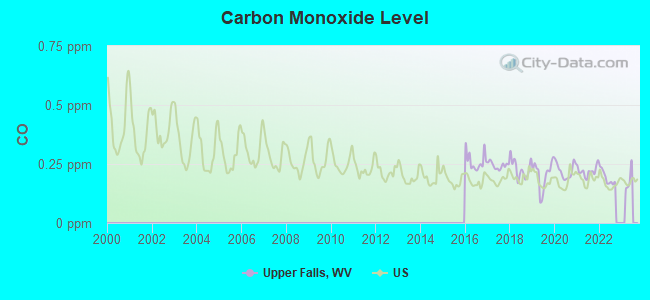
Carbon Monoxide (CO) [ppm] level in 2022 was 0.193. This is better than average. Closest monitor was 12.1 miles away from the city center.
| City: | 0.193 |
| U.S.: | 0.251 |
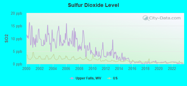
Sulfur Dioxide (SO2) [ppb] level in 2022 was 0.596. This is significantly better than average. Closest monitor was 5.1 miles away from the city center.
| City: | 0.596 |
| U.S.: | 1.515 |
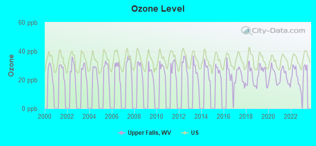
Ozone [ppb] level in 2022 was 21.7. This is significantly better than average. Closest monitor was 11.7 miles away from the city center.
| City: | 21.7 |
| U.S.: | 33.3 |
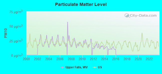
Particulate Matter (PM10) [µg/m3] level in 2015 was 11.1. This is significantly better than average. Closest monitor was 8.2 miles away from the city center.
| City: | 11.1 |
| U.S.: | 19.2 |
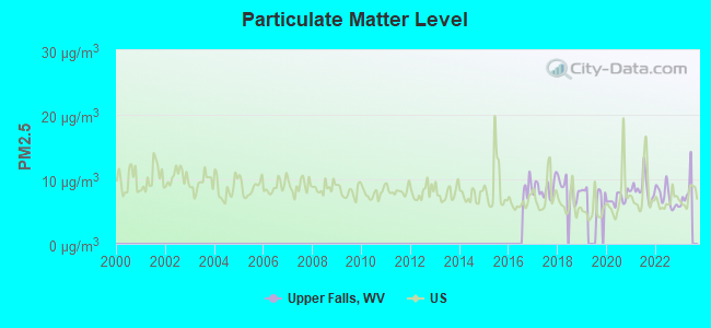
Particulate Matter (PM2.5) [µg/m3] level in 2022 was 7.21. This is about average. Closest monitor was 8.3 miles away from the city center.
| City: | 7.21 |
| U.S.: | 8.11 |
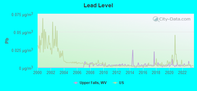
Lead (Pb) [µg/m3] level in 2022 was 0.00387. This is significantly better than average. Closest monitor was 5.1 miles away from the city center.
| City: | 0.00387 |
| U.S.: | 0.00931 |
Tornado activity:
Upper Falls-area historical tornado activity is slightly below West Virginia state average. It is 74% smaller than the overall U.S. average.
On 4/23/1968, a category F5 (max. wind speeds 261-318 mph) tornado 38.2 miles away from the Upper Falls place center killed 7 people and injured 93 people and caused between $500,000 and $5,000,000 in damages.
On 4/8/1965, a category F3 (max. wind speeds 158-206 mph) tornado 36.7 miles away from the place center injured 3 people and caused between $50,000 and $500,000 in damages.
Earthquake activity:
Upper Falls-area historical earthquake activity is significantly above West Virginia state average. It is 3% smaller than the overall U.S. average.On 8/23/2011 at 17:51:04, a magnitude 5.8 (5.8 MW, Depth: 3.7 mi, Class: Moderate, Intensity: VI - VII) earthquake occurred 214.7 miles away from Upper Falls center
On 7/27/1980 at 18:52:21, a magnitude 5.2 (5.1 MB, 4.7 MS, 5.0 UK, 5.2 UK) earthquake occurred 114.3 miles away from Upper Falls center
On 8/9/2020 at 12:07:37, a magnitude 5.1 (5.1 MW, Depth: 4.7 mi) earthquake occurred 135.6 miles away from Upper Falls center
On 9/25/1998 at 19:52:52, a magnitude 5.2 (4.8 MB, 4.3 MS, 5.2 LG, 4.5 MW, Depth: 3.1 mi) earthquake occurred 230.9 miles away from Upper Falls center
On 9/7/1988 at 02:28:09, a magnitude 4.6 (4.5 MB, 4.6 LG, Class: Light, Intensity: IV - V) earthquake occurred 111.3 miles away from the city center
On 11/2/2006 at 17:53:02, a magnitude 4.3 (4.3 MB, Depth: 0.6 mi) earthquake occurred 79.2 miles away from Upper Falls center
Magnitude types: regional Lg-wave magnitude (LG), body-wave magnitude (MB), surface-wave magnitude (MS), moment magnitude (MW)
Natural disasters:
The number of natural disasters in Kanawha County (28) is a lot greater than the US average (15).Major Disasters (Presidential) Declared: 22
Emergencies Declared: 5
Causes of natural disasters: Floods: 15, Storms: 14, Landslides: 8, Winter Storms: 5, Hurricanes: 3, Mudslides: 3, Blizzard: 1, Fire: 1, Heavy Rain: 1, Snowfall: 1, Snowstorm: 1, Tornado: 1, Wind: 1, Other: 2 (Note: some incidents may be assigned to more than one category).
Hospitals and medical centers near Upper Falls:
- HANSFORD STREET GROUP HOME (Hospital, about 4 miles away; SAINT ALBANS, WV)
- HUDSON STREET GROUP HOME (Hospital, about 4 miles away; SAINT ALBANS, WV)
- GOLDEN LIVINGCENTER - RIVERSIDE (Nursing Home, about 5 miles away; SAINT ALBANS, WV)
- VALLEY CENTER (Nursing Home, about 6 miles away; SOUTH CHARLESTON, WV)
- ARC GROUP HOME (Hospital, about 6 miles away; DUNBAR, WV)
- KANAWHA HOSPICE CARE, INC. (Hospital, about 6 miles away; DUNBAR, WV)
- FMC - KANAWHA COUNTY (Dialysis Facility, about 7 miles away; DUNBAR, WV)
Amtrak station near Upper Falls:
Colleges/universities with over 2000 students nearest to Upper Falls:
- West Virginia State University (about 5 miles; Institute, WV; Full-time enrollment: 2,133)
- Marshall University (about 33 miles; Huntington, WV; FT enrollment: 11,450)
- Ashland Community and Technical College (about 45 miles; Ashland, KY; FT enrollment: 2,482)
- New River Community and Technical College (about 51 miles; Beckley, WV; FT enrollment: 2,234)
- West Virginia University at Parkersburg (about 64 miles; Parkersburg, WV; FT enrollment: 2,619)
- Shawnee State University (about 68 miles; Portsmouth, OH; FT enrollment: 4,160)
- Big Sandy Community and Technical College (about 69 miles; Prestonsburg, KY; FT enrollment: 2,660)
Public high school in Upper Falls:
- WEBSTER COUNTY HIGH SCHOOL (Students: 505, Location: ONE HIGHLANDER DRIVE, Grades: 9-12)
Points of interest:
Notable locations in Upper Falls: Upper Falls Landing (A), Upper Falls Siding (B), Big Bend Golf Course (C), Tornado Volunteer Fire Department (D), Coal River Group Science & Education Center (E). Display/hide their locations on the map
Churches in Upper Falls include: Browns Creek Church (A), Mount Tabor Church (B), Humphreys Memorial United Methodist Church (C), New Hope Church (D), Pleasant Hill Church (E). Display/hide their locations on the map
Cemeteries: Bryant Cemetery (1), Henley Cemetery (2), Templeton Cemetery (3), Upper Falls Cemetery (4). Display/hide their locations on the map
Streams, rivers, and creeks: Smith Creek (A), Martin Creek (B), Mannens Branch (C), Mahone Branch (D), Falls Creek (E), Dry Branch (F), Bryan Branch (G), Browns Creek (H), Angel Fork (I). Display/hide their locations on the map
Beach: Upper Falls Beach (A). Display/hide its location on the map
| This place: | 2.5 people |
| West Virginia: | 2.4 people |
| This place: | 73.5% |
| Whole state: | 65.8% |
| This place: | 7.9% |
| Whole state: | 6.6% |
Likely homosexual households (counted as self-reported same-sex unmarried-partner households)
- Lesbian couples: 0.8% of all households
- Gay men: 0.4% of all households
For population 15 years and over in Upper Falls:
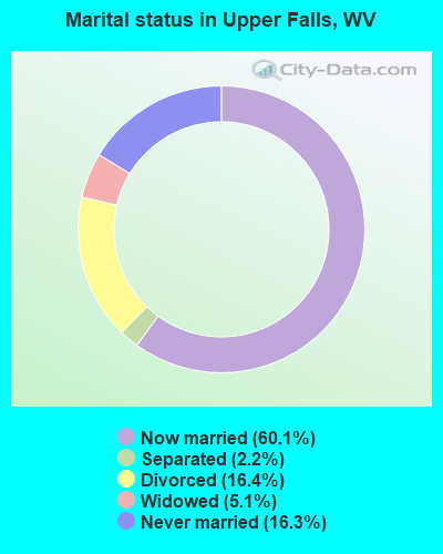
- Never married: 16.3%
- Now married: 60.1%
- Separated: 2.2%
- Widowed: 5.1%
- Divorced: 16.4%
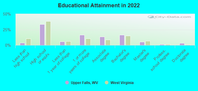
For population 25 years and over in Upper Falls:
- High school or higher: 93.0%
- Bachelor's degree or higher: 20.8%
- Graduate or professional degree: 7.4%
- Mean travel time to work (commute): 27.0 minutes
| Here: | 9.6 |
| West Virginia average: | 11.1 |
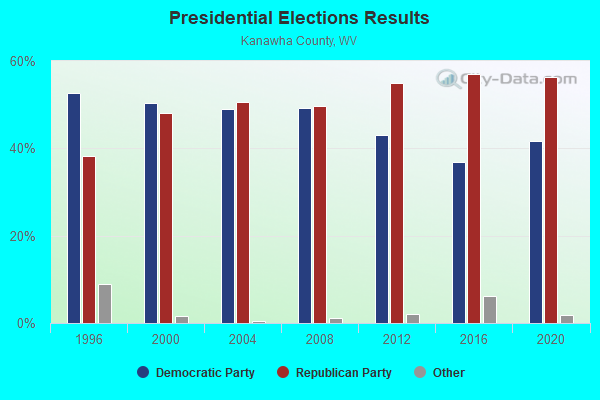
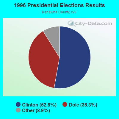
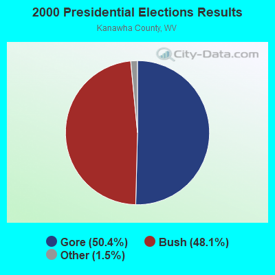
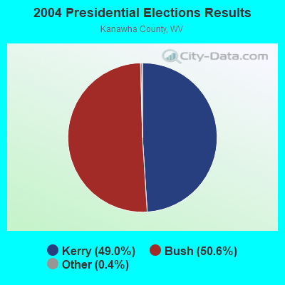
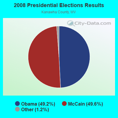
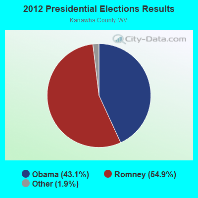
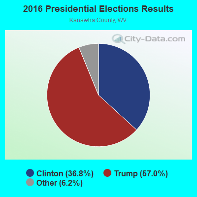
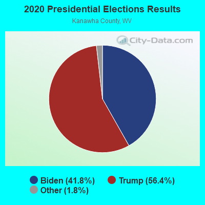
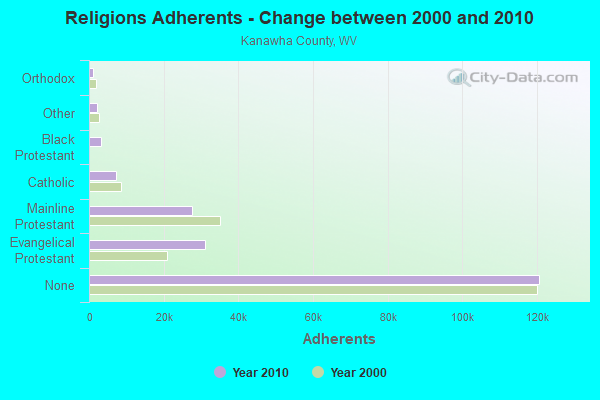
Graphs represent county-level data. Detailed 2008 Election Results
Religion statistics for Upper Falls, WV (based on Kanawha County data)
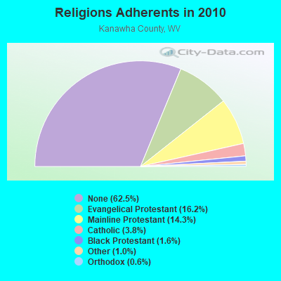
| Religion | Adherents | Congregations |
|---|---|---|
| Evangelical Protestant | 31,202 | 219 |
| Mainline Protestant | 27,583 | 114 |
| Catholic | 7,331 | 11 |
| Black Protestant | 3,114 | 12 |
| Other | 2,020 | 10 |
| Orthodox | 1,136 | 2 |
| None | 120,677 | - |
Food Environment Statistics:
| Kanawha County: | 2.46 / 10,000 pop. |
| West Virginia: | 2.41 / 10,000 pop. |
| Kanawha County: | 0.16 / 10,000 pop. |
| West Virginia: | 0.28 / 10,000 pop. |
| Kanawha County: | 0.52 / 10,000 pop. |
| West Virginia: | 1.09 / 10,000 pop. |
| Kanawha County: | 5.13 / 10,000 pop. |
| State: | 5.38 / 10,000 pop. |
| Kanawha County: | 6.90 / 10,000 pop. |
| West Virginia: | 6.22 / 10,000 pop. |
| This county: | 12.1% |
| West Virginia: | 12.2% |
| Kanawha County: | 29.6% |
| West Virginia: | 31.1% |
| This county: | 12.0% |
| West Virginia: | 13.1% |
Strongest AM radio stations in Upper Falls:
- WCHS (580 AM; 5 kW; CHARLESTON, WV; Owner: WEST VIRGINIA RADIO CORPORATION OF CHARLESTON)
- WVTS (950 AM; 5 kW; CHARLESTON, WV; Owner: BRISTOL BROADCASTING COMPANY, INC.)
- WJYP (1300 AM; 1 kW; ST. ALBANS, WV)
- WSCW (1410 AM; daytime; 5 kW; SOUTH CHARLESTON, WV; Owner: L.M. COMMUNICATIONS OF KENTUCKY, LLC)
- WCAW (680 AM; 10 kW; CHARLESTON, WV; Owner: WEST VIRGINIA RADIO CORPORATION OF CHARLESTON)
- WBES (1240 AM; 1 kW; CHARLESTON, WV; Owner: BRISTOL BROADCASTING COMPANY, INC.)
- WZZW (1600 AM; 5 kW; MILTON, WV; Owner: CAPSTAR TX LIMITED PARTNERSHIP)
- WBGS (1030 AM; daytime; 10 kW; POINT PLEASANT, WV; Owner: BIG RIVER RADIO, INC.)
- WTVN (610 AM; 50 kW; COLUMBUS, OH; Owner: CITICASTERS LICENSES, L.P.)
- WOKU (1080 AM; daytime; 1 kW; HURRICANE, WV; Owner: BIG RIVER RADIO, INC.)
- WOAY (860 AM; 10 kW; OAK HILL, WV; Owner: COMMISSIONED COMMUNICATIONS, INC.)
- WVHU (800 AM; 5 kW; HUNTINGTON, WV; Owner: CAPSTAR TX LIMITED PARTNERSHIP)
- WSWW (1490 AM; 1 kW; CHARLESTON, WV; Owner: WEST VIRGINIA RADIO CORPORATION OF CHARLESTON)
Strongest FM radio stations in Upper Falls:
- WKLC-FM (105.1 FM; ST. ALBANS, WV; Owner: WKLC, INC.)
- WQBE-FM (97.5 FM; CHARLESTON, WV; Owner: BRISTOL BROADCASTING COMPANY)
- WZJO (94.5 FM; DUNBAR, WV; Owner: BRISTOL BROADCASTING COMPANY, INC)
- WVSR-FM (102.7 FM; CHARLESTON, WV; Owner: BRISTOL BROADCASTING COMPANY, INC.)
- WVWV (89.9 FM; HUNTINGTON, WV; Owner: WEST VIRGINIA EDUCATIONAL BROADCASTING AUTHORITY)
- WJYP-FM (100.9 FM; SOUTH CHARLESTON, WV; Owner: L.M. COMMUNICATIONS OF KENTUCKY, LLC)
- WAMX (106.3 FM; MILTON, WV; Owner: CAPSTAR TX LIMITED PARTNERSHIP)
- WKWS (96.1 FM; CHARLESTON, WV; Owner: WEST VIRGINIA RADIO CORPORATION OF CHARLESTON)
- WRVZ (98.7 FM; POCATALICO, WV; Owner: WEST VIRGINIA RADIO CORPORATION OF CHARLESTON)
- WZAC-FM (92.5 FM; DANVILLE, WV; Owner: PRICE BROADCASTING COMPANY)
- WKAZ (107.3 FM; MIAMI, WV; Owner: WEST VIRGINIA RADIO CORPORATION OF CHARLESTON)
- WVAF (99.9 FM; CHARLESTON, WV; Owner: WEST VIRGINIA RADIO CORPORATION OF CHARLESTON)
- WXAF (90.9 FM; CHARLESTON, WV; Owner: MARANATHA BROADCASTING, INC.)
- WCIR-FM (103.7 FM; BECKLEY, WV; Owner: SOUTHERN COMMUNICATIONS CORPORATION)
- WVPN (88.5 FM; CHARLESTON, WV; Owner: WEST VIRGINIA EDUCATIONAL BROADCASTING AUTHORITY)
- WKVW (93.3 FM; MONTGOMERY, WV; Owner: EDUCATIONAL MEDIA FOUNDATION)
- WVOW-FM (101.9 FM; LOGAN, WV; Owner: LOGAN BROADCASTING CORP.)
- WEMM (107.9 FM; HUNTINGTON, WV; Owner: MORTENSON BROADCASTING CO. OF WEST VIRGINIA, LLC)
- W208AK (89.5 FM; CHARLESTON, WV; Owner: LOWER OHIO VALLEY EDUCATIONAL CORP.)
- WTCR-FM (103.3 FM; HUNTINGTON, WV; Owner: CAPSTAR TX LIMITED PARTNERSHIP)
TV broadcast stations around Upper Falls:
- WCHS-TV (Channel 8; CHARLESTON, WV; Owner: WCHS LICENSEE, LLC)
- WVAH-TV (Channel 11; CHARLESTON, WV; Owner: WVAH LICENSEE, LLC)
- WLPX-TV (Channel 29; CHARLESTON, WV; Owner: PAXSON CHARLESTON LICENSE, INC.)
- WPBY-TV (Channel 33; HUNTINGTON, WV; Owner: WEST VIRGINIA EDUCATIONAL BROADCASTING AUTHORITY)
- WSAZ-TV (Channel 3; HUNTINGTON, WV; Owner: EMMIS TELEVISION LICENSE CORPORATION)
- WOWK-TV (Channel 13; HUNTINGTON, WV; Owner: WEST VIRGINIA MEDIA HOLDINGS, LLC)
- W31CA (Channel 31; CHARLESTON, WV; Owner: NATIONAL MINORITY T.V., INC.)
- W36CR (Channel 36; HUNTINGTON, WV; Owner: NATIONAL MINORITY T.V., INC.)
- W16CE (Channel 16; CHARLESTON, WV; Owner: EMMIS TELEVISION LICENSE CORPORATION)
- W14CU (Channel 14; HUNTINGTON, WV; Owner: VENTANA TELEVISION, INC.)
- WOWB-LP (Channel 53; CHARLESTON, WV; Owner: COMMONWEALTH BROADCASTING GROUP, INC.)
- National Bridge Inventory (NBI) Statistics
- 6Number of bridges
- 33ft / 10.2mTotal length
- $100,000Total costs
- 3,460Total average daily traffic
- 172Total average daily truck traffic
- 4,495Total future (year 2038) average daily traffic
FCC Registered Amateur Radio Licenses:
1- Call Sign: KC8MI, Licensee ID: L00382857, Grant Date: 02/02/2019, Expiration Date: 02/02/2029, Registrant: Robert Thompson, 128 1st Ave, Upper Falls, WV 25202-9704
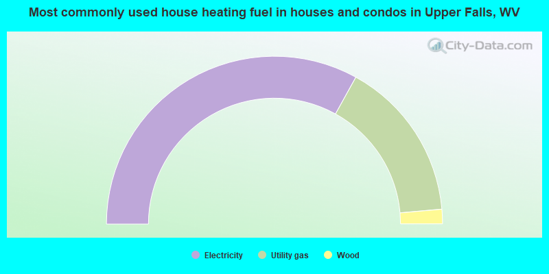
- 66.1%Electricity
- 31.1%Utility gas
- 2.8%Wood
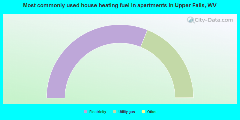
- 62.3%Electricity
- 37.7%Utility gas
Upper Falls compared to West Virginia state average:
- Unemployed percentage significantly below state average.
- Black race population percentage significantly below state average.
- Renting percentage below state average.
- Length of stay since moving in significantly below state average.
- House age below state average.