Underhill, Vermont
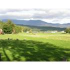
Underhill: Underhill
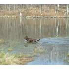
Underhill: wading canine
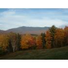
Underhill: View of Mt. Mansfield from Underhill Center
- add
your
Submit your own pictures of this town and show them to the world
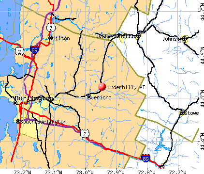
- OSM Map
- General Map
- Google Map
- MSN Map
Population change since 2000: +1.2%
 |
| Males: 1,487 | |
| Females: 1,529 |
| Median resident age: | 43.5 years |
| Vermont median age: | 45.8 years |
Zip codes: 05489.
| Underhill: | $122,200 |
| VT: | $73,991 |
Estimated per capita income in 2022: $52,358 (it was $26,746 in 2000)
Underhill town income, earnings, and wages data
Estimated median house or condo value in 2022: $486,297 (it was $157,000 in 2000)
| Underhill: | $486,297 |
| VT: | $304,700 |
Mean prices in 2022: all housing units: $491,172; detached houses: $528,845; townhouses or other attached units: $365,306; in 2-unit structures: $386,479; in 3-to-4-unit structures: over $1,000,000; in 5-or-more-unit structures: $298,866; mobile homes: $83,873
Detailed information about poverty and poor residents in Underhill, VT
Compare current foreclosures near Underhill, VT:
| Photo | Address | Area | Beds / Baths | Price | Details |
|---|---|---|---|---|---|

|
#1
Pleasant Valley Rd
Underhill, VT 05489
|
- sq. feet
|
- baths - beds |
show details | |

|
#2
Barrett St
South Burlington, VT 05403
|
1,407 sq. feet
|
2 baths 3 beds |
show details | |

|
#3
Windcrest Road
Milton, VT 05468
|
- sq. feet
|
- baths - beds |
show details | |

|
#4
Winterbury Lane, Unit 202
Burlington, VT 05401
|
- sq. feet
|
- baths - beds |
show details | |

|
#5
Roosevelt Hwy Apt 111
Colchester, VT 05446
|
- sq. feet
|
- baths - beds |
show details | |

|
#6
Williston Rd
South Burlington, VT 05403
|
- sq. feet
|
- baths - beds |
show details | |

|
#7
Lapierre Dr
Milton, VT 05468
|
- sq. feet
|
- baths - beds |
show details | |

|
#8
Elmwood Ave Apt 8
Burlington, VT 05401
|
- sq. feet
|
- baths - beds |
show details | |

|
#9
Eastwood Dr Apt 206
South Burlington, VT 05403
|
- sq. feet
|
- baths - beds |
show details | |

|
#10
Pine St Apt 2
Burlington, VT 05401
|
- sq. feet
|
- baths - beds |
show details |
| Photo | Address | Area | Beds / Baths | Price | Details |
|---|---|---|---|---|---|

|
#11
Jourdan St
Hinesburg, VT 05461
|
- sq. feet
|
- baths - beds |
show details | |

|
#12
Shelburne Rd # 309
South Burlington, VT 05403
|
- sq. feet
|
- baths - beds |
show details | |

|
#13
Sandra Cir
Burlington, VT 05408
|
- sq. feet
|
- baths - beds |
show details | |

|
#14
Hibbard Rd
Milton, VT 05468
|
- sq. feet
|
- baths - beds |
show details | |

|
#15
Franklin Sq
Burlington, VT 05408
|
- sq. feet
|
- baths - beds |
show details | |

|
#16
Hinesburg Rd Apt 103
South Burlington, VT 05403
|
- sq. feet
|
- baths - beds |
show details | |

|
#17
Bayview St
Burlington, VT 05401
|
- sq. feet
|
- baths - beds |
show details | |

|
#18
Willowbrook Ln
Williston, VT 05495
|
- sq. feet
|
- baths - beds |
show details | |

|
#19
Edgewood Dr
Colchester, VT 05446
|
- sq. feet
|
- baths - beds |
show details | |

|
#20
Shady Ln
Colchester, VT 05446
|
- sq. feet
|
- baths - beds |
show details |
| Photo | Address | Area | Beds / Baths | Price | Details |
|---|---|---|---|---|---|

|
#21
Duxfarm Ests
Waterbury, VT 05676
|
- sq. feet
|
- baths - beds |
show details | |

|
#22
Lafountain St
Winooski, VT 05404
|
- sq. feet
|
- baths - beds |
show details | |

|
#23
Vt Route 15
Jericho, VT 05465
|
- sq. feet
|
- baths - beds |
show details | |

|
#24
Colchester Rd
Essex Junction, VT 05452
|
- sq. feet
|
- baths - beds |
show details | |

|
#25
Stage Rd
Jericho, VT 05465
|
- sq. feet
|
- baths - beds |
show details | |

|
#26
Ridge Rd
Essex Junction, VT 05452
|
- sq. feet
|
- baths - beds |
show details | |

|
#27
Briar Ln
Essex Junction, VT 05452
|
- sq. feet
|
- baths - beds |
show details | |

|
#28
Elm St
Essex Junction, VT 05452
|
- sq. feet
|
- baths - beds |
show details | |

|
#29
Esplanade
Richmond, VT 05477
|
- sq. feet
|
- baths - beds |
show details | |

|
#30
Village Grv
Williston, VT 05495
|
- sq. feet
|
- baths - beds |
show details |
| Photo | Address | Area | Beds / Baths | Price | Details |
|---|---|---|---|---|---|

|
#31
Main St
Fairfax, VT 05454
|
- sq. feet
|
- baths - beds |
show details | |

|
#32
Route 7 N
Milton, VT 05468
|
- sq. feet
|
- baths - beds |
show details | |

|
#33
Old Academy St # 102
Fairfax, VT 05454
|
- sq. feet
|
- baths - beds |
show details | |

|
#34
Mountain View Rd
Williston, VT 05495
|
- sq. feet
|
- baths - beds |
show details | |

|
#35
Stonybrook Dr
Williston, VT 05495
|
- sq. feet
|
- baths - beds |
show details | |

|
#36
Woodcrest Cir
Milton, VT 05468
|
- sq. feet
|
- baths - beds |
show details | |

|
#37
Kingsbury Xing
Milton, VT 05468
|
- sq. feet
|
- baths - beds |
show details | |

|
#38
Mountain View Blvd
South Burlington, VT 05403
|
- sq. feet
|
- baths - beds |
show details | |

|
#39
Lazy Brook Dr
Starksboro, VT 05487
|
- sq. feet
|
- baths - beds |
show details | |

|
Check over 1 million property listings on Foreclosure.com!
|
browse all offers | |||

- 2,91496.6%White alone
- 431.4%Two or more races
- 240.8%Hispanic
- 180.6%Asian alone
- 120.4%Black alone
- 50.2%American Indian alone
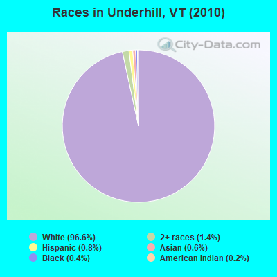
Races in Underhill detailed stats: ancestries, foreign born residents, place of birth
According to our research of Vermont and other state lists, there were 5 registered sex offenders living in Underhill, Vermont as of May 17, 2024.
The ratio of all residents to sex offenders in Underhill is 603 to 1.
The ratio of registered sex offenders to all residents in this city is lower than the state average.
 Recent articles from our blog. Our writers, many of them Ph.D. graduates or candidates, create easy-to-read articles on a wide variety of topics.

 | Need Advice. May move to Burlington for a Job (9 replies) |
| Highest Elevation Towns in the Valley Region? (5 replies) |
| Burlington Elementary Schools - Edmunds (2 replies) |
| underhill artill?ry (5 replies) |
| Less farmy, more woodsy? (10 replies) |
| Family friendly near Burlington? (17 replies) |
Latest news from Underhill, VT collected exclusively by city-data.com from local newspapers, TV, and radio stations
Ancestries: Irish (24.2%), English (21.5%), French (12.3%), German (11.4%), French Canadian (10.0%), United States (9.6%).
Current Local Time: EST time zone
Elevation: 706 feet
Land area: 51.4 square miles.
Population density: 59 people per square mile (very low).
54 residents are foreign born
| This town: | 1.8% |
| Vermont: | 3.8% |
| Underhill town: | 1.6% ($2,531) |
| Vermont: | 2.0% ($2,196) |
Nearest city with pop. 50,000+: Schenectady, NY  (129.9 miles , pop. 61,821).
Nearest city with pop. 200,000+: Boston, MA (178.7 miles , pop. 589,141).
Nearest city with pop. 1,000,000+: Bronx, NY (259.7 miles , pop. 1,332,650).
Nearest cities:
), ), ), ), Latitude: 44.54 N, Longitude: 72.92 W
Area code: 802

Underhill tourist attractions:
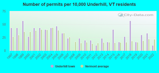
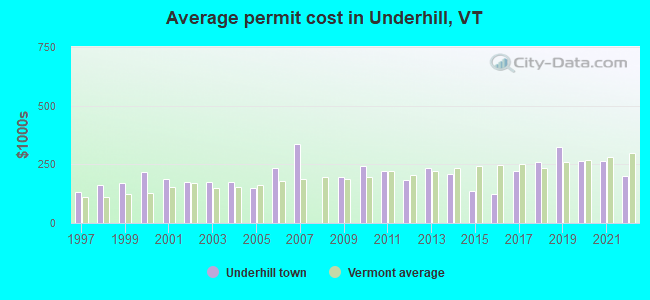
Single-family new house construction building permits:
- 2022: 3 buildings, average cost: $201,700
- 2021: 10 buildings, average cost: $262,500
- 2020: 9 buildings, average cost: $265,300
- 2019: 5 buildings, average cost: $325,400
- 2018: 17 buildings, average cost: $260,000
- 2017: 8 buildings, average cost: $224,400
- 2016: 5 buildings, average cost: $124,800
- 2015: 12 buildings, average cost: $136,700
- 2014: 5 buildings, average cost: $211,200
- 2013: 7 buildings, average cost: $233,900
- 2012: 3 buildings, average cost: $185,000
- 2011: 6 buildings, average cost: $224,200
- 2010: 6 buildings, average cost: $243,800
- 2009: 7 buildings, average cost: $194,700
- 2007: 7 buildings, average cost: $336,100
- 2006: 10 buildings, average cost: $236,500
- 2005: 14 buildings, average cost: $150,200
- 2004: 13 buildings, average cost: $176,600
- 2003: 12 buildings, average cost: $177,000
- 2002: 13 buildings, average cost: $175,100
- 2001: 13 buildings, average cost: $186,200
- 2000: 8 buildings, average cost: $217,500
- 1999: 17 buildings, average cost: $172,100
- 1998: 13 buildings, average cost: $162,300
- 1997: 13 buildings, average cost: $133,400
| Here: | 1.5% |
| Vermont: | 2.0% |
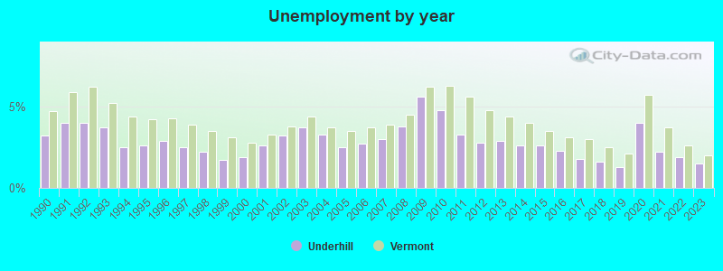
Population change in the 1990s: +53 (+1.8%).
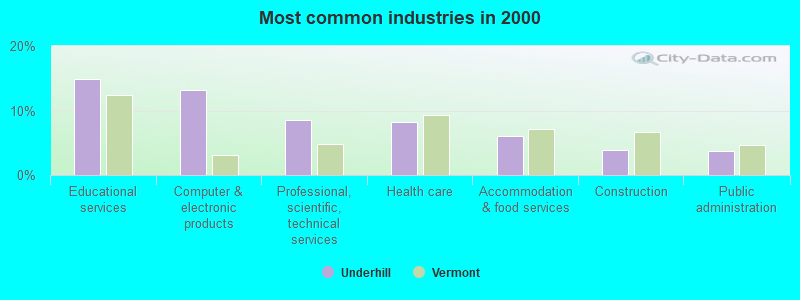
- Educational services (14.9%)
- Computer & electronic products (13.2%)
- Professional, scientific, technical services (8.5%)
- Health care (8.2%)
- Accommodation & food services (6.0%)
- Construction (3.8%)
- Public administration (3.8%)
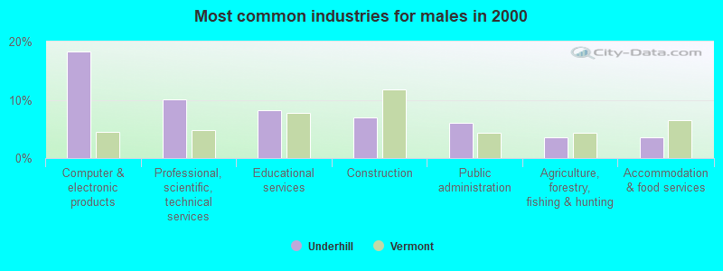
- Computer & electronic products (18.3%)
- Professional, scientific, technical services (10.1%)
- Educational services (8.3%)
- Construction (7.0%)
- Public administration (6.1%)
- Agriculture, forestry, fishing & hunting (3.6%)
- Accommodation & food services (3.6%)
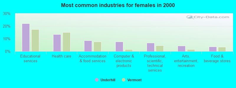
- Educational services (22.1%)
- Health care (13.5%)
- Accommodation & food services (8.6%)
- Computer & electronic products (7.7%)
- Professional, scientific, technical services (6.7%)
- Arts, entertainment, recreation (4.4%)
- Food & beverage stores (3.7%)
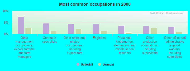
- Other management occupations, except farmers and farm managers (7.5%)
- Computer specialists (4.7%)
- Other sales and related occupations, including supervisors (4.3%)
- Engineers (4.2%)
- Preschool, kindergarten, elementary, and middle school teachers (3.6%)
- Other production occupations, including supervisors (3.4%)
- Other office and administrative support workers, including supervisors (3.1%)
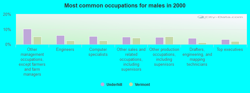
- Other management occupations, except farmers and farm managers (10.4%)
- Engineers (6.0%)
- Computer specialists (5.3%)
- Other sales and related occupations, including supervisors (4.9%)
- Other production occupations, including supervisors (4.7%)
- Drafters, engineering, and mapping technicians (4.1%)
- Top executives (3.2%)
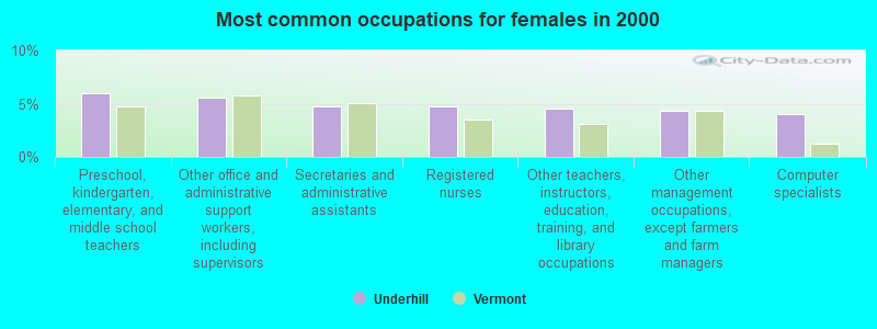
- Preschool, kindergarten, elementary, and middle school teachers (6.0%)
- Other office and administrative support workers, including supervisors (5.6%)
- Secretaries and administrative assistants (4.7%)
- Registered nurses (4.7%)
- Other teachers, instructors, education, training, and library occupations (4.5%)
- Other management occupations, except farmers and farm managers (4.4%)
- Computer specialists (4.0%)
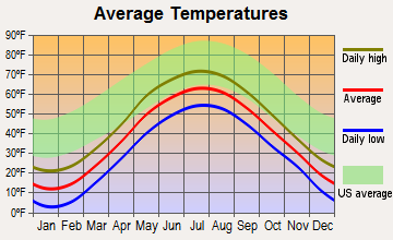
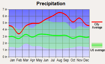
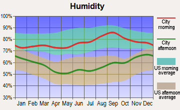
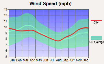
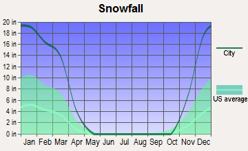
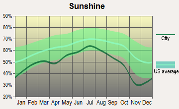
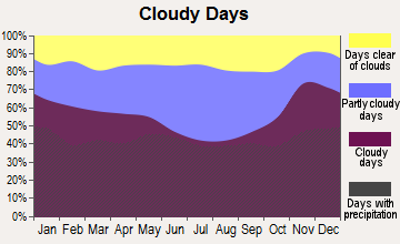
Average climate in Underhill, Vermont
Based on data reported by over 4,000 weather stations
(lower is better)
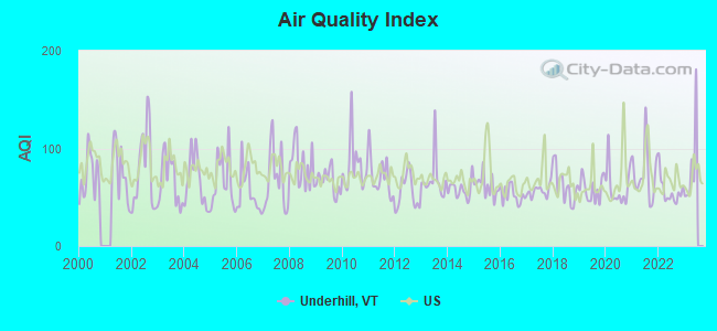
Air Quality Index (AQI) level in 2022 was 56.4. This is better than average.
| City: | 56.4 |
| U.S.: | 72.6 |
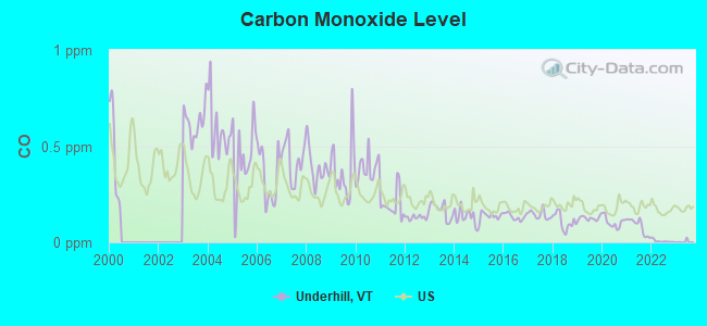
Carbon Monoxide (CO) [ppm] level in 2022 was 0.00585. This is significantly better than average. Closest monitor was 2.8 miles away from the city center.
| City: | 0.00585 |
| U.S.: | 0.25132 |
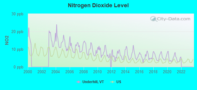
Nitrogen Dioxide (NO2) [ppb] level in 2021 was 4.81. This is about average. Closest monitor was 14.7 miles away from the city center.
| City: | 4.81 |
| U.S.: | 5.11 |
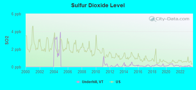
Sulfur Dioxide (SO2) [ppb] level in 2022 was 0.0619. This is significantly better than average. Closest monitor was 2.8 miles away from the city center.
| City: | 0.0619 |
| U.S.: | 1.5147 |
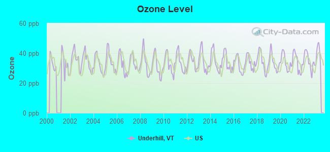
Ozone [ppb] level in 2022 was 34.8. This is about average. Closest monitor was 2.8 miles away from the city center.
| City: | 34.8 |
| U.S.: | 33.3 |
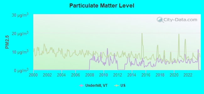
Particulate Matter (PM2.5) [µg/m3] level in 2022 was 4.70. This is significantly better than average. Closest monitor was 2.8 miles away from the city center.
| City: | 4.70 |
| U.S.: | 8.11 |
Earthquake activity:
Underhill-area historical earthquake activity is significantly above Vermont state average. It is 72% smaller than the overall U.S. average.On 4/20/2002 at 10:50:47, a magnitude 5.3 (5.3 ML, Depth: 3.0 mi, Class: Moderate, Intensity: VI - VII) earthquake occurred 38.2 miles away from the city center
On 4/20/2002 at 10:50:47, a magnitude 5.2 (5.2 MB, 4.2 MS, 5.2 MW, 5.0 MW) earthquake occurred 39.3 miles away from the city center
On 10/7/1983 at 10:18:46, a magnitude 5.3 (5.1 MB, 5.3 LG, 5.1 ML) earthquake occurred 81.0 miles away from Underhill center
On 1/19/1982 at 00:14:42, a magnitude 4.7 (4.5 MB, 4.7 MD, 4.5 LG, Class: Light, Intensity: IV - V) earthquake occurred 97.3 miles away from Underhill center
On 10/16/2012 at 23:12:25, a magnitude 4.7 (4.7 ML, Depth: 10.0 mi) earthquake occurred 130.1 miles away from Underhill center
On 6/16/1995 at 12:13:11, a magnitude 3.8 (3.8 LG, Depth: 3.1 mi, Class: Light, Intensity: II - III) earthquake occurred 52.8 miles away from the city center
Magnitude types: regional Lg-wave magnitude (LG), body-wave magnitude (MB), duration magnitude (MD), local magnitude (ML), surface-wave magnitude (MS), moment magnitude (MW)
Natural disasters:
The number of natural disasters in Chittenden County (24) is greater than the US average (15).Major Disasters (Presidential) Declared: 18
Emergencies Declared: 2
Causes of natural disasters: Floods: 16, Storms: 14, Heavy Rains: 3, Winter Storms: 2, Hurricane: 1, Ice Storm: 1, Landslide: 1, Snow: 1, Snowstorm: 1, Tropical Storm: 1, Wind: 1, Other: 1 (Note: some incidents may be assigned to more than one category).

Hospitals and medical centers near Underhill:
- GREEN MOUNTAIN NURSING AND REHABILITATION (Nursing Home, about 12 miles away; COLCHESTER, VT)
- FANNY ALLEN HOSPITAL (Hospital, about 12 miles away; WINOOSKI, VT)
- BAYADA NURSES, INC (Home Health Center, about 13 miles away; SO BURLINGTON, VT)
- FLETCHER ALLEN HEALTHCARE - MED CTR HOSP OF VT CAMPUS (Dialysis Facility, about 15 miles away; BURLINGTON, VT)
- FLETCHER ALLEN HOSPITAL OF VERMONT Acute Care Hospitals (about 15 miles away; BURLINGTON, VT)
- BURLINGTON HEALTH AND REHAB (Nursing Home, about 15 miles away; BURLINGTON, VT)
- FLETCHER ALLEN HEALTHCARE - CHITTENDEN COUNTY DIALYSIS (Dialysis Facility, about 15 miles away; SOUTH BURLINGTON, VT)
Amtrak stations near Underhill:
- 10 miles: BURLINGTON-ESSEX JUNCTION (ESSEX JUNCTION, 29 RAILROAD AVE.) . Services: ticket office, partially wheelchair accessible, enclosed waiting area, public restrooms, public payphones, vending machines, ATM, free short-term parking, free long-term parking, call for car rental service, call for taxi service, public transit connection.
- 17 miles: WATERBURY-STOWE (WATERBURY, PARK ROW) . Services: enclosed waiting area, public restrooms, public payphones, free short-term parking, free long-term parking, call for car rental service, call for taxi service, intercity bus service.
Colleges/universities with over 2000 students nearest to Underhill:
- Saint Michael's College (about 13 miles; Colchester, VT; Full-time enrollment: 2,336)
- Community College of Vermont (about 14 miles; Winooski, VT; FT enrollment: 3,394)
- University of Vermont (about 15 miles; Burlington, VT; FT enrollment: 11,566)
- Champlain College (about 15 miles; Burlington, VT; FT enrollment: 2,623)
- SUNY College at Plattsburgh (about 29 miles; Plattsburgh, NY; FT enrollment: 5,934)
- Norwich University (about 31 miles; Northfield, VT; FT enrollment: 4,221)
- Middlebury College (about 39 miles; Middlebury, VT; FT enrollment: 3,077)
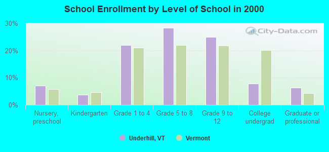
Public elementary/middle school in Underhill:
- UNDERHILL CENTRAL SCHOOL (Students: 146, Location: 6 IRISH SETTLEMENT ROAD, Grades: PK-4)
Points of interest:
Notable locations in Underhill: Taylor Lodge (A), Camp Underhill (B), Camp Mansfield (C), Halfway House (D), Underhill - Jericho Fire Department, Incorporated (E), Waters Memorial Library (F), Delaporte Memorial Library (G), Halfway House (H), Underhill Town Hall (I). Display/hide their locations on the map
Churches in Underhill include: United Church of Underhill (A), Saint Thomas Catholic Church (B). Display/hide their locations on the map
Cemeteries: Irish Settlement Cemetery (1), Valley Cemetery (2), Sand Hill Cemetery (3), Saint Thomas Cemetery (4), Pleasant Valley Cemetery (5), North Underhill Cemetery (6). Display/hide their locations on the map
Streams, rivers, and creeks: Stevensville Brook (A), Roaring Brook (B), Clay Brook (C). Display/hide their locations on the map
Birthplace of: Pat Dealy - Baseball player.
Drinking water stations with addresses in Underhill and their reported violations in the past:
JERICHO UNDERHILL WATER (Population served: 825, Groundwater):Past health violations:MAPLE LEAF FARM (Address: 10 MAPLE LEAF RD , Population served: 139, Groundwater):Past monitoring violations:
- MCL, Monthly (TCR) - In SEP-2012, Contaminant: Coliform. Follow-up actions: St Tech Assistance Visit (SEP-17-2012), St Formal NOV issued (SEP-17-2012), St Public Notif requested (SEP-17-2012), St Boil Water Order (SEP-17-2012), St Compliance achieved (SEP-21-2012)
- One routine major monitoring violation
Past health violations:Past monitoring violations:
- MCL, Monthly (TCR) - In JUL-2009, Contaminant: Coliform. Follow-up actions: St Boil Water Order (JUL-16-2009), St Formal NOV issued (JUL-16-2009), St Tech Assistance Visit (JUL-16-2009), St Public Notif requested (JUL-16-2009), St Compliance achieved (NOV-08-2010)
- MCL, Monthly (TCR) - In JUL-2008, Contaminant: Coliform. Follow-up actions: St Boil Water Order (JUL-10-2008), St Formal NOV issued (JUL-10-2008), St Tech Assistance Visit (JUL-10-2008), St Public Notif requested (JUL-10-2008), St Compliance achieved (NOV-08-2010)
- One routine major monitoring violation
- 21 regular monitoring violations
| This town: | 2.7 people |
| Vermont: | 2.3 people |
| This town: | 80.1% |
| Whole state: | 62.5% |
| This town: | 6.1% |
| Whole state: | 9.2% |
Likely homosexual households (counted as self-reported same-sex unmarried-partner households)
- Lesbian couples: 0.8% of all households
- Gay men: 0.5% of all households
| This town: | 5.2% |
| Whole state: | 9.4% |
| This town: | 1.8% |
| Whole state: | 3.6% |
For population 15 years and over in Underhill:
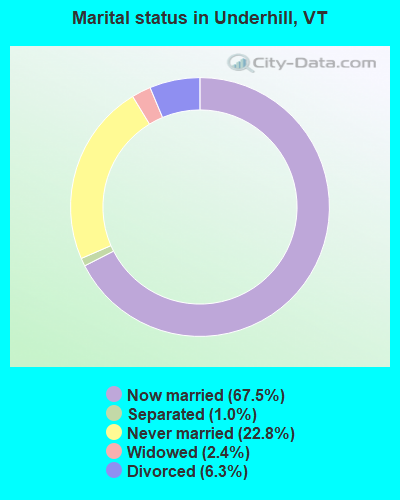
- Never married: 22.8%
- Now married: 67.5%
- Separated: 1.0%
- Widowed: 2.4%
- Divorced: 6.3%
For population 25 years and over in Underhill:
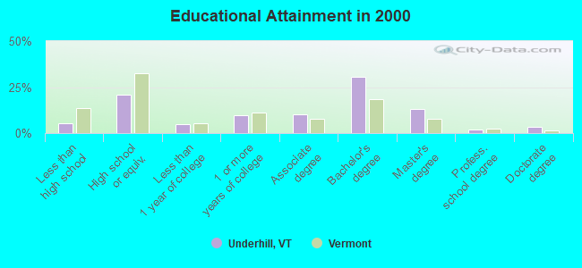
- High school or higher: 94.8%
- Bachelor's degree or higher: 48.7%
- Graduate or professional degree: 18.3%
- Unemployed: 2.3%
- Mean travel time to work (commute): 30.5 minutes
| Here: | 10.3 |
| Vermont average: | 11.7 |
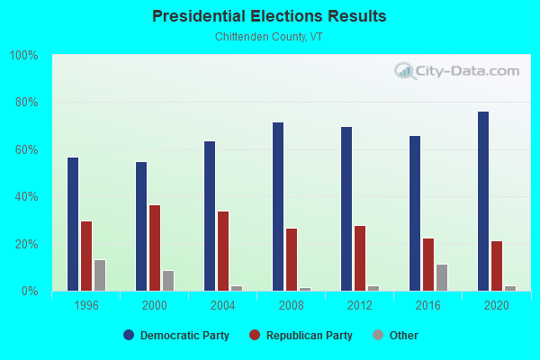
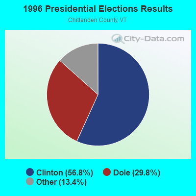
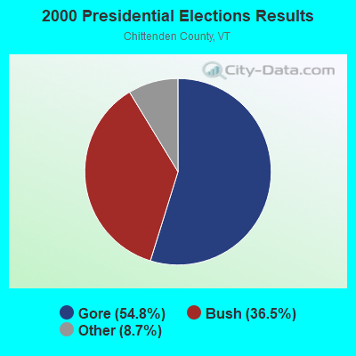
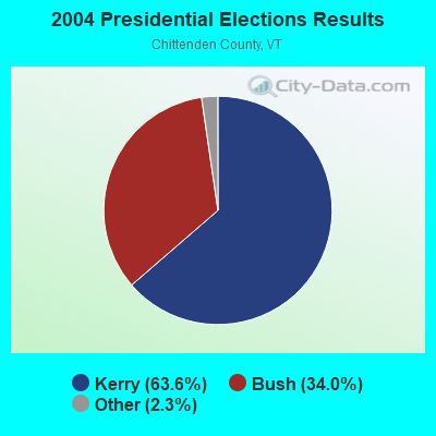

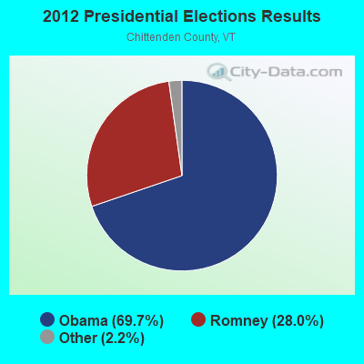
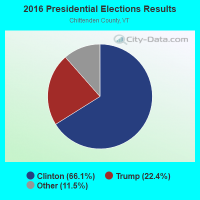
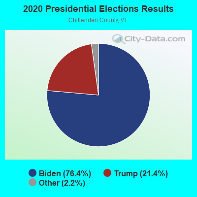
Graphs represent county-level data. Detailed 2008 Election Results
Religion statistics for Underhill, VT (based on Chittenden County data)

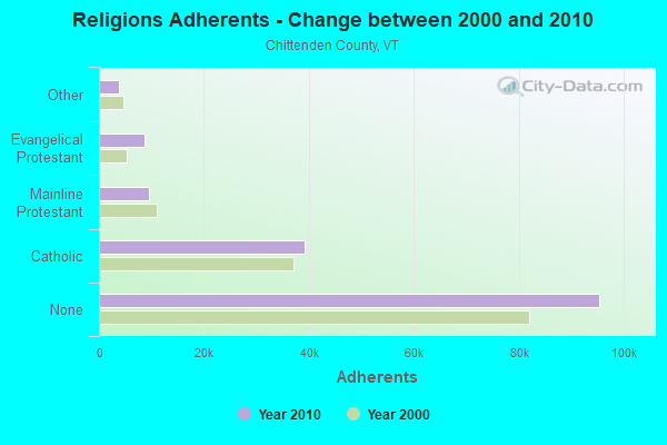
| Religion | Adherents | Congregations |
|---|---|---|
| Catholic | 39,143 | 19 |
| Mainline Protestant | 9,427 | 43 |
| Evangelical Protestant | 8,638 | 43 |
| Other | 3,891 | 20 |
| Orthodox | 100 | 1 |
| None | 95,346 | - |
Food Environment Statistics:
| Chittenden County: | 2.77 / 10,000 pop. |
| Vermont: | 3.84 / 10,000 pop. |
| Chittenden County: | 0.07 / 10,000 pop. |
| Vermont: | 0.07 / 10,000 pop. |
| Here: | 1.84 / 10,000 pop. |
| Vermont: | 1.95 / 10,000 pop. |
| Chittenden County: | 4.28 / 10,000 pop. |
| Vermont: | 6.40 / 10,000 pop. |
| Chittenden County: | 9.35 / 10,000 pop. |
| State: | 11.52 / 10,000 pop. |
| Here: | 5.3% |
| Vermont: | 6.8% |
| This county: | 18.7% |
| Vermont: | 22.3% |
| This county: | 13.8% |
| Vermont: | 13.3% |
Strongest AM radio stations in Underhill:
- WDEV (550 AM; 5 kW; WATERBURY, VT; Owner: RADIO VERMONT, INC.)
- WVMT (620 AM; 5 kW; BURLINGTON, VT; Owner: SISON BROADCASTING, INC.)
- WCHP (760 AM; 35 kW; CHAMPLAIN, NY; Owner: CHAMPLAIN RADIO, INC.)
- WVAA (1390 AM; 5 kW; BURLINGTON, VT; Owner: RADIO VERMONT, KDR, LLC)
- WEAV (960 AM; 5 kW; PLATTSBURGH, NY; Owner: CLEAR CHANNEL BROADCASTING LICENSES, INC.)
- WICY (1490 AM; 50 kW; MALONE, NY; Owner: CARTIER COMMUNICATIONS INC.)
- WTWK (1070 AM; daytime; 5 kW; PLATTSBURGH, NY; Owner: CHAMPLAIN COMMUNICATIONS CORPORATION)
- WJOY (1230 AM; 1 kW; BURLINGTON, VT; Owner: HALL COMMUNICATIONS, INC.)
- WGY (810 AM; 50 kW; SCHENECTADY, NY; Owner: CLEAR CHANNEL BROADCASTING LICENSES, INC.)
- WNNZ (640 AM; 50 kW; WESTFIELD, MA; Owner: CLEAR CHANNEL BROADCASTING LICENSES, INC.)
- WRKO (680 AM; 50 kW; BOSTON, MA; Owner: ENTERCOM BOSTON LICENSE, LLC)
- WCRN (830 AM; 50 kW; WORCESTER, MA; Owner: CARTER BROADCASTING CORPORATION)
- WPTR (1540 AM; 50 kW; ALBANY, NY; Owner: KIMTRON, INC.)
Strongest FM radio stations in Underhill:
- WEZF (92.9 FM; BURLINGTON, VT; Owner: CAPSTAR TX LIMITED PARTNERSHIP)
- WVPS (107.9 FM; BURLINGTON, VT; Owner: VERMONT PUBLIC RADIO)
- WLKC (103.3 FM; WATERBURY, VT; Owner: RADIO BROADCASTING SERVICES, INC.)
- WCVT (101.7 FM; STOWE, VT; Owner: RADIO VERMONT CLASSICS, L.L.C.)
- WNCS (104.7 FM; MONTPELIER, VT; Owner: MONTPELIER BROADCASTING, INC.)
- WGLY-FM (91.5 FM; BOLTON, VT; Owner: CHRISTIAN MINISTRIES, INC.)
- WCPV (101.3 FM; ESSEX, NY; Owner: CAPSTAR TX LIMITED PARTNERSHIP)
- WDEV-FM (96.1 FM; WARREN, VT; Owner: RADIO VERMONT, INC.)
- WCEL (91.9 FM; PLATTSBURGH, NY; Owner: WAMC)
- WLFE-FM (102.3 FM; ST. ALBANS, VT; Owner: CHAMPLAIN COMMUNICATIONS CORP.)
- WXZO (96.7 FM; WILLSBORO, NY; Owner: CAPSTAR TX LIMITED PARTNERSHIP)
- WIZN (106.7 FM; VERGENNES, VT; Owner: BURLINGTON BROADCASTERS, INC.)
- WPKQ (103.7 FM; NORTH CONWAY, NH; Owner: CITADEL BROADCASTING COMPANY)
- WHOM (94.9 FM; MT. WASHINGTON, NH; Owner: CITADEL BROADCASTING COMPANY)
- WEBK (105.3 FM; KILLINGTON, VT; Owner: 6 JOHNSON ROAD LICENSES, INC.)
- WJJR (98.1 FM; RUTLAND, VT; Owner: 6 JOHNSON ROAD LICENSES, INC.)
- WZRT (97.1 FM; RUTLAND, VT; Owner: CAPSTAR TX LIMITED PARTNERSHIP)
- WGMT (97.7 FM; LYNDON, VT; Owner: VERMONT BROADCAST ASSOCIATES, INC.)
- WDOT (95.7 FM; DANVILLE, VT; Owner: MONTPELIER BROADCASTING INC)
- WGLV (91.7 FM; WOODSTOCK, VT; Owner: CHRISTIAN MINISTRIES INC)
TV broadcast stations around Underhill:
- WVNY (Channel 22; BURLINGTON, VT; Owner: C-22 FCC LICENSEE SUBSIDIARY, LLC)
- WCAX-TV (Channel 3; BURLINGTON, VT; Owner: MT. MANSFIELD TELEVISION, INC.)
- W54CV (Channel 54; BARRE, VT; Owner: NYN, LLC)
- WETK (Channel 33; BURLINGTON, VT; Owner: VERMONT ETV, INC.)
- WPTZ (Channel 5; NORTH POLE, NY; Owner: HEARST-ARGYLE STATIONS, INC.)
- W16AL (Channel 16; BURLINGTON, VT; Owner: TRINITY BROADCASTING NETWORK)
- W19BR (Channel 19; MONKTON, VT; Owner: PLATTSBURGH PARTNERS)
- W30BL (Channel 30; BURLINGTON, VT; Owner: NYN, LLC)
- W51CB (Channel 51; BURLINGTON, VT; Owner: DEEPAK VISWANATH)
- National Bridge Inventory (NBI) Statistics
- 10Number of bridges
- 46ft / 14.3mTotal length
- $4,260,000Total costs
- 22,490Total average daily traffic
- 1,758Total average daily truck traffic
- 23,616Total future (year 2027) average daily traffic
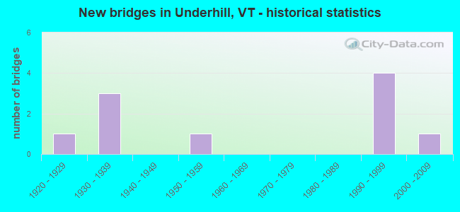
- New bridges - historical statistics
- 11920-1929
- 31930-1939
- 11950-1959
- 41990-1999
- 12000-2009
FCC Registered Antenna Towers:
5- Richard J Byrne, 0.91 Mi South Of River Road (Lat: 44.508083 Lon: -72.933694), Type: 30.2, Overall height: 27.4 m, Registrant: Wireless Applications Corporation, Fcc@wacorp.Net, , Belle-vue, Phone: (425) 643-5000
- Richard J Byrne, 0.91 Mi South Of River Road (Lat: 44.508083 Lon: -72.933694), Type: 30.2, Overall height: 27.4 m, Registrant: Wireless Applications Corporation, Fcc@wacorp.Net, , Belle-vue, Phone: (425) 643-5000
- Richard J Byrne, 0.91 Mi South Of River Road (Lat: 44.508083 Lon: -72.933694), Type: 33.2, Overall height: 30.5 m, Registrant: Wireless Applications Corporation, Fcc@wacorp.Net, , Belle-vue, Phone: (425) 643-5000
- Richard J Byrne, 0.91 Mi South Of River Road (Lat: 44.508083 Lon: -72.933694), Type: 33.2, Overall height: 30.5 m, Registrant: Wireless Applications Corporation, Fcc@wacorp.Net, , Belle-vue, Phone: (425) 643-5000
- Edward G Roach, 0.91 Mi South Of River Road (Lat: 44.508083 Lon: -72.933694), Type: 33.2, Overall height: 30.5 m, Registrant: Sba Towers Ii LLC, Eroach@sbasite.Com, , Boca -Raton, Phone: (561) 995-7670
FCC Registered Broadcast Land Mobile Towers:
1- 1/4 Mi N On Rt 15 (Lat: 44.529222 Lon: -72.944861), Call Sign: KLR475,
Assigned Frequencies: 155.775 MHz, Grant Date: 04/16/2015, Expiration Date: 04/03/2025, Registrant: Underhill Jericho Fire Department, Underhill, VT 05489, Phone: (802) 899-4025, Fax: (802) 899-5431, Email:
FCC Registered Paging Towers:
1- Mt. Mansfield Near Underhill (Lat: 44.526694 Lon: -72.815389), Structure height: 13 m, Call Sign: KWU281,
Assigned Frequencies: 454.100 MHz, 152.240 MHz, Grant Date: 04/02/2019, Expiration Date: 04/01/2029, Certifier: Kathy M Paskevich, Registrant: Jkl Communications LLC, 142 Avenue C, Williston, VT 05495, Phone: (802) 860-0000, Fax: (802) 860-5037, Email:
FCC Registered Amateur Radio Licenses:
35 (See the full list of FCC Registered Amateur Radio Licenses in Underhill)FAA Registered Aircraft:
2- Aircraft: CESSNA 172H (Category: Land, Seats: 4, Weight: Up to 12,499 Pounds, Speed: 105 mph), Engine: CONT MOTOR 0-300 SER (145 HP) (Reciprocating)
N-Number: 2593L, N2593L, N-2593L, Serial Number: 17255793, Year manufactured: 1967, Airworthiness Date: 01/25/1967, Certificate Issue Date: 06/19/2019
Registrant (Co-Owned): Moses M Daly, 414 Vt Route 15, Underhill, VT 05489, Other Owners: Douglas W Smith - Aircraft: CESSNA 310I (Category: Land, Engines: 2, Seats: 6, Weight: Up to 12,499 Pounds, Speed: 167 mph), Engine: CONT MOTOR I0-470 SERIES (260 HP) (Reciprocating)
N-Number: 8025M, N8025M, N-8025M, Serial Number: 310I0025, Year manufactured: 1964, Certificate Issue Date: 10/26/2012
Registrant (Individual): Kyle Clark, 102 Irish Settlement Rd, Underhill, VT 05489
Deregistered: Cancel Date: 02/16/2018
2002 - 2018 National Fire Incident Reporting System (NFIRS) incidents
- Fire incident types reported to NFIRS in Underhill, VT
- 12063.2%Structure Fires
- 4322.6%Outside Fires
- 1910.0%Mobile Property/Vehicle Fires
- 84.2%Other
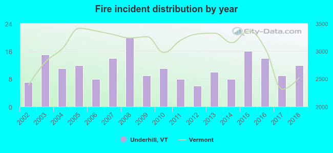 Based on the data from the years 2002 - 2018 the average number of fire incidents per year is 11. The highest number of reported fire incidents - 20 took place in 2008, and the least - 6 in 2012. The data has an increasing trend.
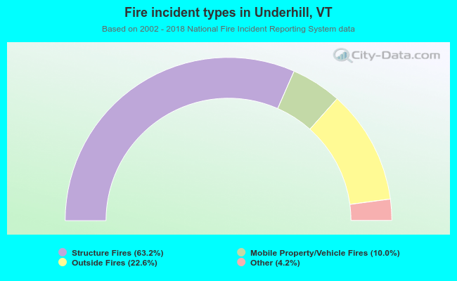 When looking into fire subcategories, the most incidents belonged to: Structure Fires (63.2%), and Outside Fires (22.6%).
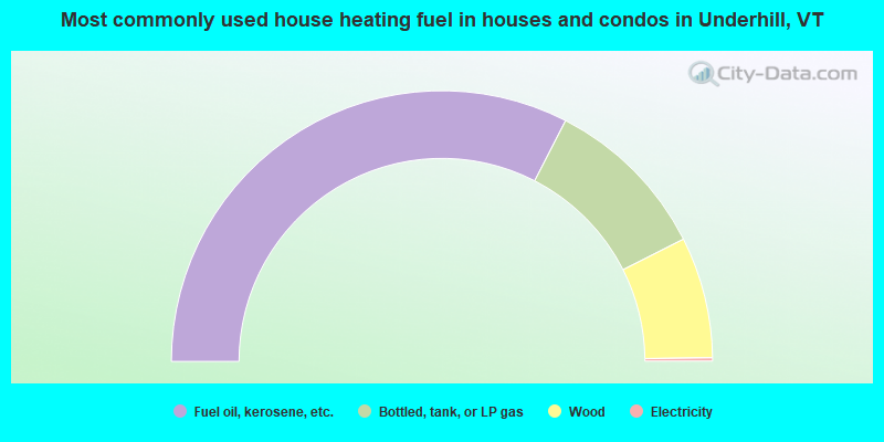
- 65.1%Fuel oil, kerosene, etc.
- 20.0%Bottled, tank, or LP gas
- 14.5%Wood
- 0.4%Electricity
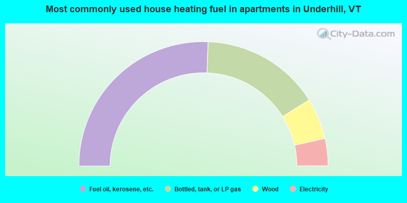
- 51.2%Fuel oil, kerosene, etc.
- 31.0%Bottled, tank, or LP gas
- 10.7%Wood
- 7.1%Electricity
Underhill compared to Vermont state average:
- Median household income above state average.
- Median house value above state average.
- Unemployed percentage significantly below state average.
- Black race population percentage below state average.
- Hispanic race population percentage below state average.
- Foreign-born population percentage significantly below state average.
- Renting percentage significantly below state average.
- Length of stay since moving in significantly above state average.
- Number of rooms per house significantly below state average.
- House age significantly below state average.
- Percentage of population with a bachelor's degree or higher above state average.

|
|
Total of 560 patent applications in 2008-2024.