Turner, Oregon
Submit your own pictures of this city and show them to the world
- OSM Map
- General Map
- Google Map
- MSN Map
Population change since 2000: +102.0%
| Males: 1,249 | |
| Females: 1,173 |
| Median resident age: | 39.1 years |
| Oregon median age: | 40.5 years |
Zip codes: 97392.
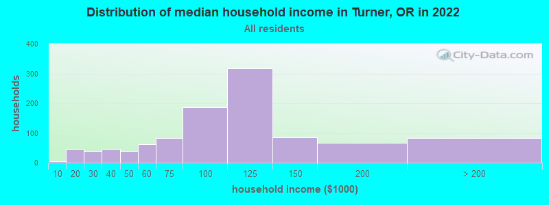
| Turner: | $101,429 |
| OR: | $75,657 |
Estimated per capita income in 2022: $38,998 (it was $26,234 in 2000)
Turner city income, earnings, and wages data
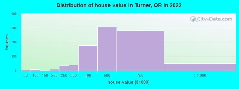
Estimated median house or condo value in 2022: $476,819 (it was $124,500 in 2000)
| Turner: | $476,819 |
| OR: | $475,600 |
Mean prices in 2022: all housing units: $420,232; detached houses: $448,964; townhouses or other attached units: $408,768; in 2-unit structures: $324,996; in 3-to-4-unit structures: $335,275; in 5-or-more-unit structures: $272,662; mobile homes: $216,537; occupied boats, rvs, vans, etc.: $57,358
Median gross rent in 2022: $1,108.
Detailed information about poverty and poor residents in Turner, OR


Compare current foreclosures near Turner, OR:
| Photo | Address | Area | Beds / Baths | Price | Details |
|---|---|---|---|---|---|

|
#1
Stayton Rd SE
Turner, OR 97392
|
832 sq. feet
|
1 baths 2 beds |
show details | |

|
#2
Holly Loop SE
Turner, OR 97392
|
1,054 sq. feet
|
2 baths 3 beds |
show details | |

|
#3
2nd St SE
Turner, OR 97392
|
1,174 sq. feet
|
2 baths 3 beds |
show details | |

|
#4
Valley View Rd SE
Turner, OR 97392
|
1,932 sq. feet
|
1 baths 3 beds |
show details | |

|
#5
Holly Loop SE
Turner, OR 97392
|
1,054 sq. feet
|
2 baths 3 beds |
show details | |

|
#6
Holly Loop SE
Turner, OR 97392
|
1,008 sq. feet
|
2 baths 3 beds |
show details | |

|
#7
Apollo St SE
Turner, OR 97392
|
2,196 sq. feet
|
2 baths 3 beds |
show details | |

|
#8
Clover Ln SE
Turner, OR 97392
|
1,590 sq. feet
|
2 baths 3 beds |
show details | |

|
#9
Heathfield Ln SE
Turner, OR 97392
|
3,763 sq. feet
|
3 baths 5 beds |
show details | |

|
#10
Shade Tree Ln SE
Turner, OR 97392
|
566 sq. feet
|
1 baths - beds |
show details |
| Photo | Address | Area | Beds / Baths | Price | Details |
|---|---|---|---|---|---|

|
#11
Penny Ln SE
Turner, OR 97392
|
- sq. feet
|
- baths - beds |
show details | |

|
#12
9th Ct SE
Turner, OR 97392
|
- sq. feet
|
- baths - beds |
show details | |

|
#13
Bates St Se, Apt 204
Turner, OR 97392
|
- sq. feet
|
- baths - beds |
show details | |

|
#14
Elgin St SE
Turner, OR 97392
|
- sq. feet
|
- baths - beds |
show details | |

|
#15
Bates St Se, Apt 301
Turner, OR 97392
|
- sq. feet
|
- baths - beds |
show details | |

|
#16
Ridgeway Dr SE
Turner, OR 97392
|
- sq. feet
|
- baths - beds |
show details | |

|
#17
Bates Rd SE
Aumsville, OR 97325
|
1,920 sq. feet
|
2 baths 3 beds |
show details | |

|
#18
Regal Dr NE
Salem, OR 97301
|
1,732 sq. feet
|
3 baths 5 beds |
show details | |

|
#19
Azalea Ave SE
Albany, OR 97322
|
2,131 sq. feet
|
2 baths 4 beds |
show details | |

|
#20
Webb Lake Dr NE
Silverton, OR 97381
|
1,864 sq. feet
|
2 baths 3 beds |
show details |
| Photo | Address | Area | Beds / Baths | Price | Details |
|---|---|---|---|---|---|

|
#21
Waller St SE
Salem, OR 97302
|
1,112 sq. feet
|
1 baths 3 beds |
show details | |

|
#22
S 2nd Pl
Jefferson, OR 97352
|
1,321 sq. feet
|
2 baths 3 beds |
show details | |

|
#23
6th St NW
Salem, OR 97304
|
- sq. feet
|
2 baths 4 beds |
show details | |

|
#24
Marlatt Rd S
Jefferson, OR 97352
|
1,196 sq. feet
|
1 baths 2 beds |
show details | |

|
#25
Broadway St NE
Salem, OR 97301
|
884 sq. feet
|
1 baths 2 beds |
show details | |

|
#26
Stayton Scio Rd SE
Stayton, OR 97383
|
2,282 sq. feet
|
3 baths 3 beds |
show details | |

|
#27
Sagrada Cir N
Salem, OR 97303
|
1,460 sq. feet
|
2 baths 3 beds |
show details | |

|
#28
Rickreall Rd
Independence, OR 97351
|
2,432 sq. feet
|
1 baths 3 beds |
show details | |

|
#29
E St
Independence, OR 97351
|
1,392 sq. feet
|
2 baths 3 beds |
show details | |

|
#30
E Del Mar
Aumsville, OR 97325
|
1,651 sq. feet
|
2 baths 4 beds |
show details |
| Photo | Address | Area | Beds / Baths | Price | Details |
|---|---|---|---|---|---|

|
#31
Periwinkle Dr SE
Salem, OR 97317
|
- sq. feet
|
3 baths 4 beds |
show details | |

|
#32
Arcade Ave NE
Salem, OR 97303
|
1,495 sq. feet
|
2 baths 3 beds |
show details | |

|
#33
Chapman St S
Salem, OR 97306
|
2,720 sq. feet
|
3 baths 5 beds |
show details | |

|
#34
Crater Ave N
Salem, OR 97303
|
1,297 sq. feet
|
2 baths 3 beds |
show details | |

|
#35
W Main St
Lyons, OR 97358
|
1,824 sq. feet
|
2 baths 3 beds |
show details | |

|
#36
Washington St SW
Albany, OR 97321
|
1,116 sq. feet
|
1 baths 2 beds |
show details | |

|
#37
20th St NE
Salem, OR 97301
|
1,020 sq. feet
|
2 baths 3 beds |
show details | |

|
#38
Hawksview Ave SE
Salem, OR 97306
|
1,683 sq. feet
|
3 baths 3 beds |
show details | |

|
#39
Mcclellan Ln SE
Aumsville, OR 97325
|
988 sq. feet
|
1 baths 2 beds |
show details | |

|
#40
Hazelgreen Rd NE
Salem, OR 97305
|
1,236 sq. feet
|
2 baths 3 beds |
show details |
| Photo | Address | Area | Beds / Baths | Price | Details |
|---|---|---|---|---|---|

|
#41
45th Ave NE
Salem, OR 97305
|
1,440 sq. feet
|
2 baths 3 beds |
show details | |

|
#42
Frontier Dr NW
Salem, OR 97304
|
2,752 sq. feet
|
2 baths 5 beds |
show details | |

|
#43
Ward Dr NE
Salem, OR 97305
|
1,713 sq. feet
|
1 baths 3 beds |
show details | |

|
#44
S Main St
Jefferson, OR 97352
|
2,400 sq. feet
|
2 baths 4 beds |
show details | |

|
#45
Iberis St NE
Salem, OR 97305
|
1,872 sq. feet
|
2 baths 4 beds |
show details | |

|
#46
Sieberg St NE
Salem, OR 97303
|
1,452 sq. feet
|
2 baths 3 beds |
show details | |

|
#47
Brogan Ave NE
Salem, OR 97305
|
1,622 sq. feet
|
2 baths 3 beds |
show details | |

|
#48
Westfarthing Way NW
Salem, OR 97304
|
1,990 sq. feet
|
2 baths 3 beds |
show details | |

|
#49
Columbia St
Jefferson, OR 97352
|
1,145 sq. feet
|
1 baths 3 beds |
show details | |

|
Check over 1 million property listings on Foreclosure.com!
|
browse all offers | |||


- 2,23179.7%White alone
- 39214.0%Hispanic
- 722.6%Two or more races
- 351.3%Asian alone
- 140.5%Other race alone
- 110.4%Black alone
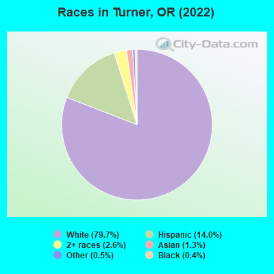
Races in Turner detailed stats: ancestries, foreign born residents, place of birth
According to our research of Oregon and other state lists, there were 5 registered sex offenders living in Turner, Oregon as of May 22, 2024.
The ratio of all residents to sex offenders in Turner is 475 to 1.
Type |
2009 |
2010 |
2011 |
2012 |
2013 |
2014 |
2015 |
2016 |
2017 |
2018 |
2019 |
2020 |
|---|---|---|---|---|---|---|---|---|---|---|---|---|
| Murders (per 100,000) | 0 (0.0) | 0 (0.0) | 0 (0.0) | 3 (158.8) | 1 (52.7) | 0 (0.0) | 0 (0.0) | 0 (0.0) | 0 (0.0) | 0 (0.0) | 0 (0.0) | 0 (0.0) |
| Rapes (per 100,000) | 1 (56.1) | 0 (0.0) | 1 (53.4) | 0 (0.0) | 0 (0.0) | 0 (0.0) | 2 (102.2) | 0 (0.0) | 0 (0.0) | 1 (46.9) | 0 (0.0) | 0 (0.0) |
| Robberies (per 100,000) | 0 (0.0) | 0 (0.0) | 1 (53.4) | 0 (0.0) | 0 (0.0) | 0 (0.0) | 0 (0.0) | 0 (0.0) | 1 (48.5) | 0 (0.0) | 0 (0.0) | 0 (0.0) |
| Assaults (per 100,000) | 7 (392.4) | 4 (215.7) | 10 (533.6) | 2 (105.9) | 0 (0.0) | 1 (52.6) | 1 (51.1) | 0 (0.0) | 3 (145.6) | 1 (46.9) | 2 (93.0) | 0 (0.0) |
| Burglaries (per 100,000) | 12 (672.6) | 16 (863.0) | 5 (266.8) | 6 (317.6) | 7 (369.2) | 6 (315.5) | 0 (0.0) | 5 (248.8) | 1 (48.5) | 5 (234.6) | 3 (139.5) | 1 (46.4) |
| Thefts (per 100,000) | 37 (2,074) | 27 (1,456) | 19 (1,014) | 23 (1,218) | 15 (791.1) | 31 (1,630) | 14 (715.4) | 7 (348.3) | 8 (388.2) | 16 (750.8) | 9 (418.4) | 8 (371.6) |
| Auto thefts (per 100,000) | 2 (112.1) | 1 (53.9) | 1 (53.4) | 8 (423.5) | 2 (105.5) | 2 (105.2) | 2 (102.2) | 3 (149.3) | 1 (48.5) | 0 (0.0) | 3 (139.5) | 1 (46.4) |
| Arson (per 100,000) | 1 (56.1) | 3 (161.8) | 0 (0.0) | 0 (0.0) | 0 (0.0) | 0 (0.0) | 0 (0.0) | 1 (49.8) | 0 (0.0) | 0 (0.0) | 0 (0.0) | 0 (0.0) |
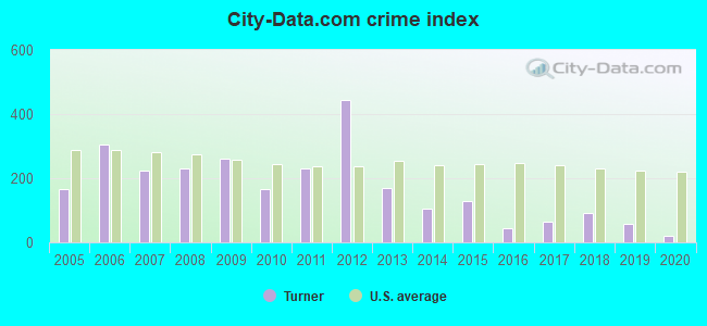
| City-Data.com crime index | 262.3 | 166.1 | 228.9 | 443.6 | 171.4 | 106.2 | 128.8 | 43.3 | 66.5 | 93.4 | 56.3 | 21.8 |
The City-Data.com crime index weighs serious crimes and violent crimes more heavily. Higher means more crime, U.S. average is 246.1. It adjusts for the number of visitors and daily workers commuting into cities.
Crime rate in Turner detailed stats: murders, rapes, robberies, assaults, burglaries, thefts, arson
Full-time law enforcement employees in 2021, including police officers: 2 (2 officers - 2 male; 0 female).
| Officers per 1,000 residents here: | 0.93 |
| Oregon average: | 1.48 |
 Recent articles from our blog. Our writers, many of them Ph.D. graduates or candidates, create easy-to-read articles on a wide variety of topics.

 | Cabins in Turner/Enchanted Forest? (3 replies) |
| Small towns surrounding salem (12 replies) |
| Possible move from Nashville, TN to the Salem area for OSU internship. Locals input appreciated. (12 replies) |
| Best/Worst small towns in the general Salem area? (28 replies) |
| "peace sign" lake near Turner (jail)??? (8 replies) |
| Restarting a business in Salem area? (5 replies) |
Latest news from Turner, OR collected exclusively by city-data.com from local newspapers, TV, and radio stations
Turner, OR City Guides:
Ancestries: German (17.4%), American (10.6%), English (7.5%), European (5.8%), Finnish (4.5%), Italian (4.4%).
Current Local Time: PST time zone
Incorporated in 1905
Elevation: 285 feet
Land area: 1.54 square miles.
Population density: 1,572 people per square mile (low).
120 residents are foreign born (3.0% Latin America, 0.7% Asia).
| This city: | 4.3% |
| Oregon: | 9.8% |
Median real estate property taxes paid for housing units with mortgages in 2022: $3,282 (0.7%)
Median real estate property taxes paid for housing units with no mortgage in 2022: $1,882 (0.4%)
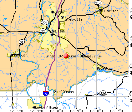
Nearest city with pop. 50,000+: Salem, OR  (7.0 miles , pop. 136,924).
Nearest city with pop. 200,000+: Northwest Clackamas, OR (41.5 miles , pop. 224,220).
Nearest city with pop. 1,000,000+: Los Angeles, CA (783.0 miles , pop. 3,694,820).
Nearest cities:
), ), )Latitude: 44.85 N, Longitude: 122.95 W

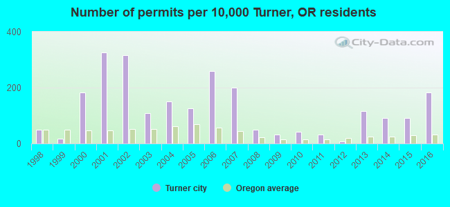
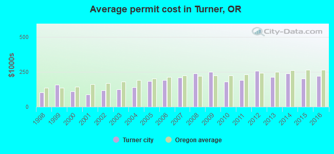
Single-family new house construction building permits:
- 2016: 22 buildings, average cost: $219,600
- 2015: 11 buildings, average cost: $200,000
- 2014: 11 buildings, average cost: $236,800
- 2013: 14 buildings, average cost: $210,700
- 2012: 1 building, cost: $255,000
- 2011: 4 buildings, average cost: $190,000
- 2010: 5 buildings, average cost: $178,500
- 2009: 4 buildings, average cost: $251,100
- 2008: 6 buildings, average cost: $239,000
- 2007: 24 buildings, average cost: $208,800
- 2006: 31 buildings, average cost: $189,800
- 2005: 15 buildings, average cost: $182,300
- 2004: 18 buildings, average cost: $138,600
- 2003: 13 buildings, average cost: $122,600
- 2002: 38 buildings, average cost: $119,300
- 2001: 39 buildings, average cost: $87,300
- 2000: 22 buildings, average cost: $108,600
- 1999: 2 buildings, average cost: $156,400
- 1998: 6 buildings, average cost: $102,000
| Here: | 3.9% |
| Oregon: | 3.9% |
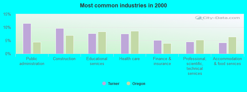
- Public administration (11.5%)
- Construction (9.7%)
- Educational services (7.7%)
- Health care (7.5%)
- Finance & insurance (5.1%)
- Professional, scientific, technical services (4.6%)
- Accommodation & food services (4.2%)
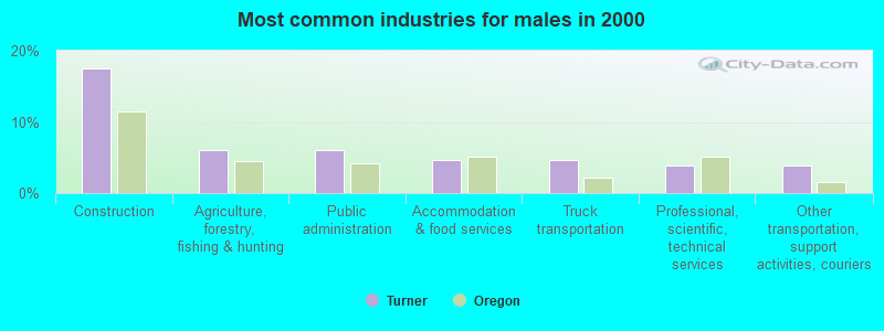
- Construction (17.5%)
- Agriculture, forestry, fishing & hunting (6.1%)
- Public administration (6.1%)
- Accommodation & food services (4.6%)
- Truck transportation (4.6%)
- Professional, scientific, technical services (3.9%)
- Other transportation, support activities, couriers (3.9%)
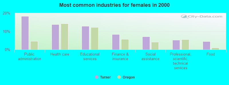
- Public administration (18.2%)
- Health care (13.8%)
- Educational services (12.9%)
- Finance & insurance (8.4%)
- Social assistance (7.1%)
- Professional, scientific, technical services (5.3%)
- Food (4.4%)
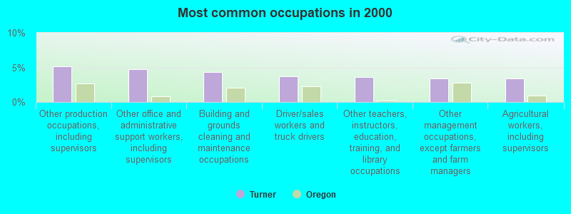
- Other production occupations, including supervisors (5.1%)
- Other office and administrative support workers, including supervisors (4.8%)
- Building and grounds cleaning and maintenance occupations (4.4%)
- Driver/sales workers and truck drivers (3.8%)
- Other teachers, instructors, education, training, and library occupations (3.6%)
- Other management occupations, except farmers and farm managers (3.4%)
- Agricultural workers, including supervisors (3.4%)
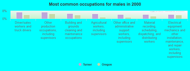
- Driver/sales workers and truck drivers (6.8%)
- Other production occupations, including supervisors (6.8%)
- Building and grounds cleaning and maintenance occupations (5.4%)
- Agricultural workers, including supervisors (5.0%)
- Other office and administrative support workers, including supervisors (4.3%)
- Material recording, scheduling, dispatching, and distributing workers (4.3%)
- Electrical equipment mechanics and other installation, maintenance, and repair workers, including supervisors (4.3%)

- Other teachers, instructors, education, training, and library occupations (8.0%)
- Other office and administrative support workers, including supervisors (5.3%)
- Information and record clerks, except customer service representatives (4.0%)
- Retail sales workers, except cashiers (4.0%)
- Child care workers (4.0%)
- Bookkeeping, accounting, and auditing clerks (4.0%)
- Secretaries and administrative assistants (3.6%)
Average climate in Turner, Oregon
Based on data reported by over 4,000 weather stations


|
|


(lower is better)
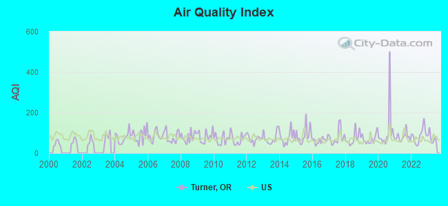
Air Quality Index (AQI) level in 2023 was 74.2. This is about average.
| City: | 74.2 |
| U.S.: | 72.6 |
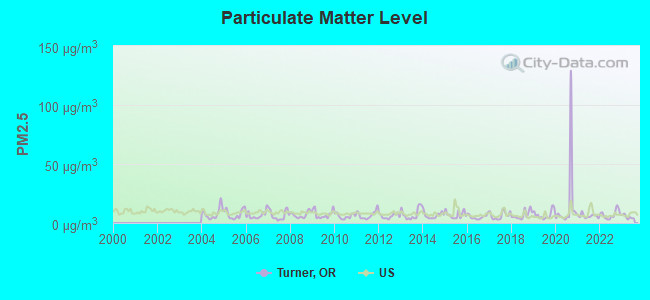
Particulate Matter (PM2.5) [µg/m3] level in 2023 was 5.03. This is significantly better than average. Closest monitor was 7.2 miles away from the city center.
| City: | 5.03 |
| U.S.: | 8.11 |
Earthquake activity:
Turner-area historical earthquake activity is significantly above Oregon state average. It is 1392% greater than the overall U.S. average.On 4/13/1949 at 19:55:42, a magnitude 7.0 (7.0 UK, Class: Major, Intensity: VIII - XII) earthquake occurred 167.7 miles away from Turner center, causing $80,000,000 total damage
On 1/31/1922 at 13:17:28, a magnitude 7.6 (7.6 UK) earthquake occurred 315.6 miles away from Turner center
On 2/28/2001 at 18:54:32, a magnitude 6.8 (6.5 MB, 6.6 MS, 6.8 MW, Class: Strong, Intensity: VII - IX) earthquake occurred 156.2 miles away from Turner center, causing $2,000,000,000 total damage and $305,000,000 insured losses
On 2/28/2001 at 18:54:32, a magnitude 6.8 (6.8 MD, Depth: 32.2 mi) earthquake occurred 159.7 miles away from Turner center
On 11/8/1980 at 10:27:34, a magnitude 7.2 (6.2 MB, 7.2 MS, 7.2 MW, 7.0 ML) earthquake occurred 267.2 miles away from Turner center
On 8/17/1991 at 22:17:14, a magnitude 7.1 (6.2 MB, 7.1 MS, 7.1 MW, 6.8 ML, Depth: 8.4 mi) earthquake occurred 251.9 miles away from the city center
Magnitude types: body-wave magnitude (MB), duration magnitude (MD), local magnitude (ML), surface-wave magnitude (MS), moment magnitude (MW)
Natural disasters:
The number of natural disasters in Marion County (10) is smaller than the US average (15).Major Disasters (Presidential) Declared: 8
Emergencies Declared: 1
Causes of natural disasters: Floods: 4, Winter Storms: 3, Landslides: 2, Mudslides: 2, Snows: 2, Storms: 2, Earthquake: 1, Fire: 1, Heavy Rain: 1, Hurricane: 1, Wind: 1, Other: 1 (Note: some incidents may be assigned to more than one category).

Hospitals and medical centers near Turner:
- KINDRED NURSING AND REHABILITATION - SUNNYSIDE (Nursing Home, about 6 miles away; SALEM, OR)
- WVP HOME HEALTH (Home Health Center, about 6 miles away; SALEM, OR)
- AMEDISYS HOME HEALTH CARE (Home Health Center, about 7 miles away; SALEM, OR)
- SALEM DIALYSIS (Dialysis Facility, about 7 miles away; SALEM, OR)
- QUALICENTERS - SALEM LTD (Dialysis Facility, about 7 miles away; SALEM, OR)
- AVAMERE REHABILITATION OF SALEM (Nursing Home, about 7 miles away; SALEM, OR)
- SOUTH SALEM CARE CENTER (Nursing Home, about 7 miles away; SALEM, OR)
Amtrak stations near Turner:
- 7 miles: SALEM (500 13TH ST. SE) . Services: ticket office, fully wheelchair accessible, public payphones, vending machines, free short-term parking, free long-term parking, call for taxi service, public transit connection.
- 17 miles: ALBANY (110 SW 10TH AVE.) . Services: ticket office, fully wheelchair accessible, enclosed waiting area, public restrooms, public payphones, vending machines, free short-term parking, free long-term parking, call for taxi service, public transit connection.
Colleges/universities with over 2000 students nearest to Turner:
- Willamette University (about 8 miles; Salem, OR; Full-time enrollment: 2,551)
- Chemeketa Community College (about 10 miles; Salem, OR; FT enrollment: 10,746)
- Western Oregon University (about 15 miles; Monmouth, OR; FT enrollment: 5,131)
- Linn-Benton Community College (about 20 miles; Albany, OR; FT enrollment: 4,511)
- Oregon State University (about 26 miles; Corvallis, OR; FT enrollment: 23,206)
- George Fox University (about 32 miles; Newberg, OR; FT enrollment: 2,954)
- Pioneer Pacific College (about 35 miles; Wilsonville, OR; FT enrollment: 2,194)
Public high school in Turner:
- CASCADE SENIOR HIGH SCHOOL (Students: 766, Location: 10226 MARION RD SE, Grades: 9-12)
Private high school in Turner:
Public elementary/middle schools in Turner:
- CASCADE JUNIOR HIGH SCHOOL (Students: 530, Location: 10226 MARION RD SE, Grades: 6-8)
- TURNER ELEMENTARY SCHOOL (Students: 169, Location: 7800 SCHOOL AVE, Grades: KG-5)
- CLOVERDALE ELEMENTARY SCHOOL (Students: 112, Location: 9666 PARRISH GAP RD SE, Grades: KG-5)
Points of interest:
Notable locations in Turner: Salem Water Treatment Plant (A), Aldersgate Conference Center (B), Turner Public Works Department Office (C), Turner Municipal Court (D), Turner City Hall (E), Turner Fire Department (F). Display/hide their locations on the map
Church in Turner: Turner Christian Church (A). Display/hide its location on the map
Cemetery: Twin Oaks Cemetery (1). Display/hide its location on the map
Reservoir: Franzen Reservoir (A). Display/hide its location on the map
Tourist attractions: Thrill-Ville USA (Amusement & Theme Parks; 8372 Enchanted Way Southeast), Travel Solutions (13565 Duckflat Road Se), Enchanted Forest (Arcades & Amusements; 8462 Enchanted Way Southeast).
Drinking water stations with addresses in Turner and their reported violations in the past:
WEYERHAEUSER NR TURNER GREENHOUSE (Population served: 40, Groundwater):Past health violations:Past monitoring violations:
- MCL, Monthly (TCR) - Between JUL-2013 and SEP-2013, Contaminant: Coliform. Follow-up actions: St Public Notif received (JUL-24-2013), St Public Notif requested (JUL-24-2013), St Compliance achieved (OCT-18-2013)
- MCL, Monthly (TCR) - In MAY-2012, Contaminant: Coliform. Follow-up actions: St Public Notif requested (JUN-19-2012), St Violation/Reminder Notice (JUN-25-2012), St Compliance achieved (NOV-09-2012)
- MCL, Monthly (TCR) - Between APR-2012 and JUN-2012, Contaminant: Coliform. Follow-up actions: St Public Notif received (APR-20-2012), St Public Notif requested (APR-20-2012), St Violation/Reminder Notice (2 times from MAY-30-2012 to JUN-26-2012), St Compliance achieved (NOV-09-2012)
- Monitoring, Source Water (GWR) - In APR-24-2014, Contaminant: E. COLI
- Monitoring, Source Water (GWR) - In AUG-11-2012, Contaminant: E. COLI. Follow-up actions: St Violation/Reminder Notice (OCT-01-2012), St Compliance achieved (NOV-09-2012)
- Monitoring, Repeat Major (TCR) - Between JUL-2012 and SEP-2012, Contaminant: Coliform (TCR). Follow-up actions: St Public Notif requested (AUG-30-2012), St Violation/Reminder Notice (OCT-01-2012), St Compliance achieved (NOV-09-2012)
- Monitoring, Source Water (GWR) - In MAY-01-2012, Contaminant: E. COLI. Follow-up actions: St Violation/Reminder Notice (JUN-25-2012), St Compliance achieved (NOV-09-2012)
- 5 routine major monitoring violations
| This city: | 2.6 people |
| Oregon: | 2.5 people |
| This city: | 72.3% |
| Whole state: | 63.4% |
| This city: | 5.8% |
| Whole state: | 8.0% |
Likely homosexual households (counted as self-reported same-sex unmarried-partner households)
- Lesbian couples: 0.3% of all households
- Gay men: 0.0% of all households
For population 15 years and over in Turner:
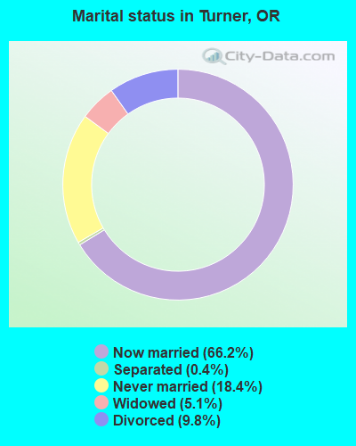
- Never married: 18.4%
- Now married: 66.2%
- Separated: 0.4%
- Widowed: 5.1%
- Divorced: 9.8%
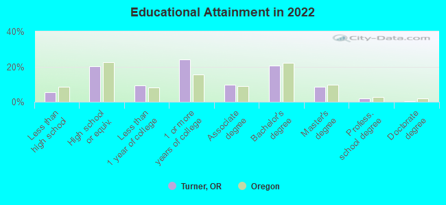
For population 25 years and over in Turner:
- High school or higher: 93.8%
- Bachelor's degree or higher: 29.7%
- Graduate or professional degree: 9.7%
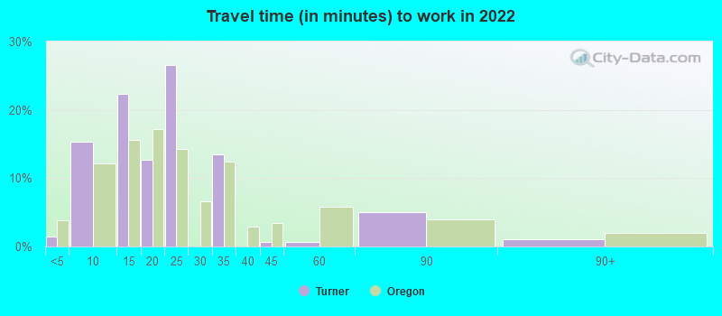
- Unemployed: 6.1%
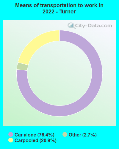
- Mean travel time to work (commute): 20.2 minutes
| Here: | 7.9 |
| Oregon average: | 11.6 |

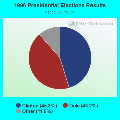
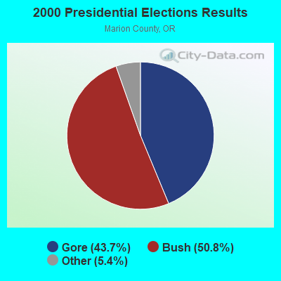
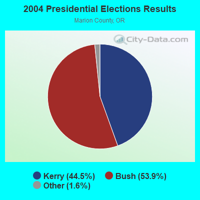
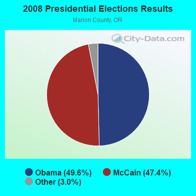
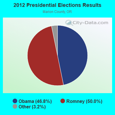
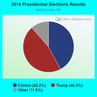
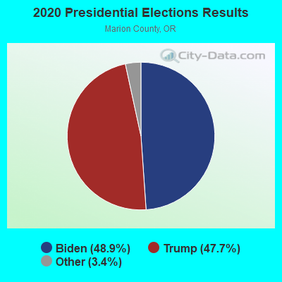
Graphs represent county-level data. Detailed 2008 Election Results
Religion statistics for Turner, OR (based on Marion County data)
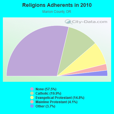
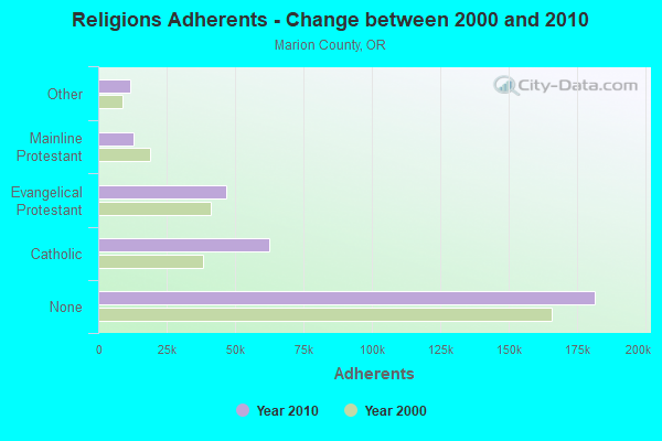
| Religion | Adherents | Congregations |
|---|---|---|
| Catholic | 62,607 | 15 |
| Evangelical Protestant | 46,619 | 186 |
| Mainline Protestant | 12,797 | 41 |
| Other | 11,663 | 46 |
| Black Protestant | 189 | 1 |
| Orthodox | - | - |
| None | 181,460 | - |
Food Environment Statistics:
| Marion County: | 1.71 / 10,000 pop. |
| Oregon: | 2.03 / 10,000 pop. |
| Marion County: | 0.29 / 10,000 pop. |
| State: | 0.33 / 10,000 pop. |
| Marion County: | 1.61 / 10,000 pop. |
| Oregon: | 2.01 / 10,000 pop. |
| Marion County: | 1.52 / 10,000 pop. |
| Oregon: | 1.69 / 10,000 pop. |
| Here: | 6.68 / 10,000 pop. |
| Oregon: | 9.93 / 10,000 pop. |
| This county: | 8.2% |
| State: | 7.4% |
| Here: | 29.5% |
| Oregon: | 25.6% |
| Marion County: | 18.4% |
| Oregon: | 14.2% |
Health and Nutrition:
| This city: | 50.6% |
| State: | 49.6% |
| Turner: | 47.1% |
| Oregon: | 46.8% |
| Here: | 28.6 |
| State: | 28.5 |
| Here: | 21.9% |
| State: | 21.2% |
| Turner: | 10.9% |
| Oregon: | 10.1% |
| Here: | 6.9 |
| Oregon: | 6.8 |
| Turner: | 34.2% |
| Oregon: | 33.3% |
| Turner: | 55.4% |
| Oregon: | 56.5% |
| Turner: | 76.1% |
| Oregon: | 78.7% |
More about Health and Nutrition of Turner, OR Residents
| Local government employment and payroll (March 2022) | |||||
| Function | Full-time employees | Monthly full-time payroll | Average yearly full-time wage | Part-time employees | Monthly part-time payroll |
|---|---|---|---|---|---|
| Financial Administration | 3 | $11,138 | $44,552 | 0 | $0 |
| Other Government Administration | 2 | $17,577 | $105,462 | 2 | $2,658 |
| Police Protection - Officers | 2 | $11,192 | $67,152 | 0 | $0 |
| Water Supply | 1 | $6,126 | $73,512 | 0 | $0 |
| Parks and Recreation | 1 | $6,638 | $79,656 | 0 | $0 |
| Sewerage | 0 | $0 | 1 | $1,602 | |
| Totals for Government | 9 | $52,671 | $70,228 | 3 | $4,260 |
Turner government finances - Expenditure in 2018 (per resident):
- Construction - Regular Highways: $123,000 ($50.78)
Water Utilities: $53,000 ($21.88)
Housing and Community Development: $15,000 ($6.19)
Central Staff Services: $14,000 ($5.78)
Parks and Recreation: $11,000 ($4.54)
Police Protection: $5,000 ($2.06)
- Current Operations - Water Utilities: $251,000 ($103.63)
Police Protection: $247,000 ($101.98)
Central Staff Services: $202,000 ($83.40)
Housing and Community Development: $191,000 ($78.86)
Protective Inspection and Regulation - Other: $178,000 ($73.49)
Sewerage: $130,000 ($53.67)
Regular Highways: $121,000 ($49.96)
Financial Administration: $72,000 ($29.73)
Parks and Recreation: $62,000 ($25.60)
Natural Resources - Other: $38,000 ($15.69)
Judicial and Legal Services: $29,000 ($11.97)
- General - Interest on Debt: $185,000 ($76.38)
- Intergovernmental to Local - Other - Sewerage: $227,000 ($93.72)
Other - Regular Highways: $111,000 ($45.83)
Other - Water Utilities: $80,000 ($33.03)
Other - Police Protection: $6,000 ($2.48)
Other - Judicial and Legal Services: $1,000 ($0.41)
Other - Central Staff Services: $1,000 ($0.41)
Other - Parks and Recreation: $1,000 ($0.41)
- Intergovernmental to State - Police Protection: $31,000 ($12.80)
Judicial and Legal Services: $2,000 ($0.83)
- Other Capital Outlay - Central Staff Services: $215,000 ($88.77)
Housing and Community Development: $125,000 ($51.61)
- Total Salaries and Wages: $762,000 ($314.62)
- Water Utilities - Interest on Debt: $59,000 ($24.36)
Turner government finances - Revenue in 2018 (per resident):
- Charges - Sewerage: $603,000 ($248.97)
Other: $41,000 ($16.93)
- Local Intergovernmental - Highways: $66,000 ($27.25)
- Miscellaneous - Interest Earnings: $44,000 ($18.17)
Rents: $34,000 ($14.04)
Fines and Forfeits: $31,000 ($12.80)
Sale of Property: $30,000 ($12.39)
General Revenue - Other: $30,000 ($12.39)
Donations From Private Sources: $3,000 ($1.24)
- Revenue - Water Utilities: $500,000 ($206.44)
- State Intergovernmental - Highways: $116,000 ($47.89)
General Local Government Support: $63,000 ($26.01)
Other: $51,000 ($21.06)
- Tax - Other License: $1,093,000 ($451.28)
Property: $490,000 ($202.31)
Public Utilities Sales: $116,000 ($47.89)
Turner government finances - Debt in 2018 (per resident):
- Long Term Debt - Beginning Outstanding - Unspecified Public Purpose: $5,689,000 ($2348.89)
Outstanding Unspecified Public Purpose: $5,665,000 ($2338.98)
Retired Unspecified Public Purpose: $223,000 ($92.07)
Issue, Unspecified Public Purpose: $199,000 ($82.16)
- Short Term Debt Outstanding - End of Fiscal Year: $240,000 ($99.09)
Beginning: $166,000 ($68.54)
Turner government finances - Cash and Securities in 2018 (per resident):
- Other Funds - Cash and Securities: $2,875,000 ($1187.04)
Strongest AM radio stations in Turner:
- KYKN (1430 AM; 5 kW; KEIZER, OR; Owner: WILLAMETTE BROADCASTING CO., INC.)
- KSLM (1390 AM; 10 kW; SALEM, OR)
- KPOJ (620 AM; 50 kW; PORTLAND, OR; Owner: CITICASTERS LICENSES, L.P.)
- KXL (750 AM; 50 kW; PORTLAND, OR; Owner: ROSE CITY RADIO CORPORATION)
- KOAC (550 AM; 5 kW; CORVALLIS, OR; Owner: OREGON PUBLIC BROADCASTING)
- KEX (1190 AM; 50 kW; PORTLAND, OR; Owner: CITICASTERS LICENSES, L.P.)
- KWIP (880 AM; 5 kW; DALLAS, OR; Owner: JUPITER COMMUNICATIONS CORPORATION)
- KKSN (1520 AM; 50 kW; OREGON CITY, OR; Owner: ENTERCOM PORTLAND LICENSE, LLC)
- KPAM (860 AM; 50 kW; TROUTDALE, OR; Owner: PAMPLIN BROADCASTING-OREGON, INC.)
- KOTK (1080 AM; 50 kW; PORTLAND, OR; Owner: FISHER BROADCASTING - PORTLAND RADIO, L.L.C.)
- KCCS (1220 AM; 1 kW; SALEM, OR; Owner: CHRISTIAN CENTER OF SALEM)
- KPNW (1120 AM; 50 kW; EUGENE, OR; Owner: CAPSTAR TX LIMITED PARTNERSHIP)
- KKAD (1550 AM; 50 kW; VANCOUVER, WA; Owner: PAMPLIN BROADCASTING-WASHINGTON, INC)
Strongest FM radio stations in Turner:
- K231AB (94.1 FM; TURNER, OR; Owner: STATE OF OREGON / STATE BOARD OF EDUCATION)
- KLVU (107.1 FM; SWEET HOME, OR; Owner: EDUCATIONAL MEDIA FOUNDATION)
- KHPE (107.9 FM; ALBANY, OR; Owner: INTEGRITY MEDIA, INC.)
- K264AA (100.7 FM; CORVALLIS, ETC., OR; Owner: THE KBOO FOUNDATION)
- KLOO-FM (106.3 FM; CORVALLIS, OR; Owner: CITICASTERS LICENSES, L.P.)
- KRKT-FM (99.9 FM; ALBANY, OR; Owner: CITICASTERS LICENSES, L.P.)
- K243AL (96.5 FM; CORVALLIS, OR; Owner: CUMULUS LICENSING CORP.)
- KRSK (105.1 FM; MOLALLA, OR; Owner: ENTERCOM PORTLAND LICENSE, LLC)
- KXPC-FM (103.7 FM; LEBANON, OR; Owner: PORTLAND BROADCASTING, L.L.C.)
- K276BU (103.1 FM; CORVALLIS, OR; Owner: OREGON PUBLIC BROADCASTING)
- K273AJ (102.5 FM; ELWOOD, OR; Owner: CALVARY CHAPEL OF TWIN FALLS, INC.)
- K207BX (89.3 FM; EUGENE, OR; Owner: PENSACOLA CHRISTIAN COLLEGE, INC.)
- K203BT (88.5 FM; EUGENE, OR; Owner: CALVARY CHAPEL OF TWIN FALLS, INC.)
- K214CI (90.7 FM; EUGENE, OR; Owner: EDUCATIONAL MEDIA FOUNDATION)
- KDUK-FM (104.7 FM; FLORENCE, OR; Owner: CAPSTAR TX LIMITED PARTNERSHIP)
- KFLY (101.5 FM; CORVALLIS, OR; Owner: CITICASTERS LICENSES, L.P.)
- K228DT (93.5 FM; HAPPY HOLLOW, OR; Owner: OREGON PUBLIC BROADCASTING)
- KWBX (90.3 FM; SALEM, OR; Owner: WESTERN BAPTIST COLLEGE)
- KEHK (102.3 FM; BROWNSVILLE, OR; Owner: CUMULUS LICENSING CORP.)
- KINK (101.9 FM; PORTLAND, OR; Owner: INFINITY RADIO OPERATIONS INC.)
TV broadcast stations around Turner:
- KPXG (Channel 22; SALEM, OR; Owner: PAXSON SALEM LICENSE, INC.)
- K67GU (Channel 67; EUREKA, CA; Owner: MS COMMUNICATIONS, LLC)
- KWBP (Channel 32; SALEM, OR; Owner: TRIBUNE BROADCAST HOLDINGS, INC.)
- K61CC (Channel 61; SALEM, OR; Owner: NORTHWEST CHRISTIAN BROADCASTING)
- K50GG (Channel 50; SALEM, OR; Owner: MEREDITH CORPORATION)
- KOAC-TV (Channel 7; CORVALLIS, OR; Owner: OREGON PUBLIC BROADCASTING)
- K14GW (Channel 14; CORVALLIS, OR; Owner: CALIFORNIA OREGON BROADCASTING, INC.)
Turner fatal accident list:
Mar 12, 2000 02:00 PM, Delaney Rd Se, Lat: 44.846132, Lon: -122.961521, Vehicles: 2, Persons: 2, Fatalities: 1
Jul 2, 1988 10:35 PM, Wipperroad, Vehicles: 1, Persons: 1, Fatalities: 1, Drunk persons involved: 1
Dec 29, 1987 10:35 PM, Chicago, Vehicles: 1, Persons: 8, Fatalities: 1, Drunk persons involved: 1
Aug 18, 1984 08:00 PM, A568, Vehicles: 1, Persons: 2, Fatalities: 1
Feb 2, 1977 03:30 PM, Vehicles: 2, Persons: 4, Fatalities: 1
Dec 23, 1977 10:06 PM, Vehicles: 1, Persons: 2, Fatalities: 1, Drunk persons involved: 1
- National Bridge Inventory (NBI) Statistics
- 10Number of bridges
- 102ft / 30.9mTotal length
- $2,231,000Total costs
- 41,950Total average daily traffic
- 3,359Total average daily truck traffic
- 46,865Total future (year 2025) average daily traffic
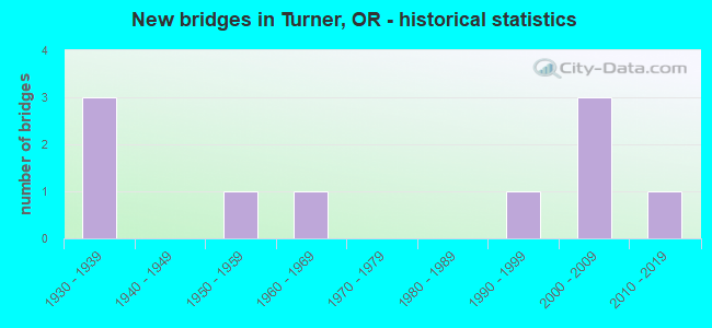
- New bridges - historical statistics
- 31930-1939
- 11950-1959
- 11960-1969
- 11990-1999
- 32000-2009
- 12010-2019
FCC Registered Antenna Towers:
53 (See the full list of FCC Registered Antenna Towers in Turner)FCC Registered Broadcast Land Mobile Towers:
6- TURNER PTC RADIO, Turner Ptc Radio Site, 5182 Delany Rd So East (Lat: 44.846028 Lon: -122.954417), Type: Mtower, Structure height: 18.3 m, Call Sign: KVR724,
Assigned Frequencies: 161.550 MHz, Grant Date: 03/19/2024, Expiration Date: 04/24/2034, Certifier: L J Kopiasz, Registrant: Concentrix, 222 So 15th St. Suite 505n, Omaha, NE 68102, Phone: (402) 262-4785, Email:
- Lat: 40.507889 Lon: -123.573722, Structure height: 0 m, Call Sign: WPKB309,
Assigned Frequencies: 48.4200 MHz, 47.8600 MHz, Grant Date: 01/15/2002, Expiration Date: 01/15/2012, Cancellation Date: 03/17/2012, Certifier: Brad Kunda, Registrant: Cara Enterprises Inc, 1270 Fairfield Rd Ste 13, Salt Lake City, UT 84117-0503, Phone: (801) 278-9728, Fax: (801) 278-7239, Email:
- MARION RADIO, Marion Radio Site, 10860 Duckflat Re Se (Lat: 44.799556 Lon: -122.936778), Type: Pole, Structure height: 12.2 m, Call Sign: WQEI958,
Assigned Frequencies: 457.337 MHz, Grant Date: 01/23/2016, Expiration Date: 02/07/2026, Certifier: Larry Kopiasz, Registrant: Prokarma, 222 So 15th St. Suite 505n, Omaha, NE 68102, Phone: (402) 522-5068, Fax: (402) 346-6676, Email:
- Lat: 44.833361 Lon: -123.008583, Call Sign: WQNL768,
Assigned Frequencies: 451.962 MHz, 452.212 MHz, 461.562 MHz, 462.012 MHz, 462.087 MHz, 462.162 MHz, 463.462 MHz, 463.612 MHz, 464.437 MHz, 464.912 MHz, Grant Date: 03/16/2011, Expiration Date: 03/16/2021, Cancellation Date: 05/22/2021, Certifier: Mary A Tofte, Registrant: Complete Wireless Solutions, 1758 22nd St. Se, Salem, OR 97302, Phone: (503) 362-1388, Fax: (503) 362-1559, Email:
- Lat: 44.507889 Lon: -123.573722, Call Sign: WQPL848,
Assigned Frequencies: 47.8600 MHz, 48.4200 MHz, Grant Date: 04/07/2022, Expiration Date: 06/25/2032, Certifier: Tom Oliver, Registrant: Consumers Power Inc, Philomath, OR 97370, Phone: (541) 929-3124, Email:
- Lat: 44.842361 Lon: -122.942667, Call Sign: WQUJ677,
Assigned Frequencies: 159.645 MHz, 160.050 MHz, 160.095 MHz, Grant Date: 07/28/2014, Expiration Date: 07/28/2024, Certifier: Eric Mueller, Registrant: Radio Licensing Service, Milwaukie, OR 97269, Phone: (503) 659-1240, Fax: (503) 659-4723, Email:
FCC Registered Microwave Towers:
7- Franzen C12 1/2 Mi N Of (Lat: 44.849278 Lon: -122.952583), Overall height: 39.9 m, Call Sign: WNTW812,
Assigned Frequencies: 928.243 MHz, 952.243 MHz, Grant Date: 09/12/2019, Expiration Date: 12/06/2029, Registrant: City Of Salem, 1410 20th Street Se Bldg #2, Salem, OR 97302, Phone: (503) 361-2219
- WHIPPER, 4.13 Miles Ssw Of Intersection Delany Road Se And Interstate 5 (Lat: 44.782833 Lon: -122.996806), Type: Tower, Structure height: 19.5 m, Overall height: 20.7 m, Call Sign: WQNL287,
Assigned Frequencies: 11455.0 MHz, Grant Date: 12/16/2020, Expiration Date: 03/11/2031, Certifier: Virgil L Hamm, Registrant: Marion County Public Works, 5155 Silverton Rd Ne, Salem, OR 97305, Phone: (503) 588-5299, Email:
- Summit, 11923 Summit Loop Rd Se (Lat: 44.783083 Lon: -122.996833), Type: Tower, Structure height: 30.5 m, Overall height: 33.5 m, Call Sign: WQON244,
Assigned Frequencies: 11505.0 MHz, Grant Date: 11/22/2011, Expiration Date: 11/22/2021, Cancellation Date: 01/22/2022, Certifier: Steven Sugg, Registrant: Snake River Solutions, LLC, 1025 Main St, Aumsville, OR 97325, Phone: (503) 743-0111, Fax: (206) 338-2453, Email:
- PO72XC031, 7050 5th Street (Lat: 44.852861 Lon: -122.959500), Type: Ltower, Structure height: 57.9 m, Call Sign: WQQT245,
Assigned Frequencies: 17815.0 MHz, 17865.0 MHz, Grant Date: 02/26/2013, Expiration Date: 02/26/2023, Cancellation Date: 02/24/2023, Certifier: David Werblow, Registrant: T-Mobile Usa, Inc., 12920 Se 38th St, Bellevue, WA 98006, Phone: (425) 383-8401, Fax: (202) 799-5616, Email:
- TURNER, 7050 5th Street (Lat: 44.852861 Lon: -122.959500), Type: Mtower, Structure height: 54.9 m, Overall height: 57.9 m, Call Sign: WQSS223,
Assigned Frequencies: 6004.50 MHz, 6004.50 MHz, 6004.50 MHz, 6004.50 MHz, 6004.50 MHz, 6004.50 MHz, Grant Date: 11/06/2013, Expiration Date: 11/06/2023, Cancellation Date: 01/24/2023, Certifier: Gregory M Romano, Registrant: Verizon, 5055 Northpointe Pkwy, Alpharetta, GA 30022, Phone: (770) 797-1070, Email:
- Summit Loop, Unnamed Road (Lat: 44.783278 Lon: -122.996861), Type: Ltower, Structure height: 33.5 m, Call Sign: WREM400,
Assigned Frequencies: 11155.0 MHz, 10755.0 MHz, 11155.0 MHz, 10755.0 MHz, 11155.0 MHz, 10755.0 MHz, 11155.0 MHz, 10755.0 MHz, 11155.0 MHz, 10755.0 MHz... (+102 more), Grant Date: 11/04/2019, Expiration Date: 11/04/2029, Certifier: Adam Skaer, Registrant: Micronet Communications, Inc., 812 Lexington Dr, Plano, TX 75075, Phone: (972) 422-7200, Email:
- WIPPER HILL, 5 Miles Sw Of (Lat: 44.782889 Lon: -122.996472), Overall height: 23.8 m, Call Sign: WCU520,
Assigned Frequencies: 10795.0 MHz, 10795.0 MHz, 10835.0 MHz, 10835.0 MHz, 10875.0 MHz, 10875.0 MHz, 10995.0 MHz, 10995.0 MHz, 10955.0 MHz, 10955.0 MHz, 11035.0 MHz, 11035.0 MHz, Grant Date: 09/06/2000, Expiration Date: 08/01/2010, Cancellation Date: 04/23/2003, Registrant: Qwest Corporation, 700 W Mineral Ave. Room Ia C7.36, Littleton, CO 80120, Phone: (303) 707-8706, Fax: (303) 707-9711, Email:
FCC Registered Amateur Radio Licenses:
67 (See the full list of FCC Registered Amateur Radio Licenses in Turner)FAA Registered Aircraft:
6- Aircraft: CESSNA 180K (Category: Land, Seats: 4, Weight: Up to 12,499 Pounds, Speed: 114 mph), Engine: Reciprocating
N-Number: 2914K, N2914K, N-2914K, Serial Number: 18053127, Certificate Issue Date: 01/12/2018
Registrant (Corporation): Freedom Precast Inc, Po Box 865, Turner, OR 97392
Deregistered: Cancel Date: 02/06/1952 - Aircraft: BELLANCA 7GCBC (Category: Land, Seats: 2, Weight: Up to 12,499 Pounds, Speed: 90 mph), Engine: LYCOMING 0-320 SERIES (180 HP) (Reciprocating)
N-Number: 4111Y, N4111Y, N-4111Y, Serial Number: 946-76, Year manufactured: 1976, Airworthiness Date: 07/22/1976, Certificate Issue Date: 10/25/2013
Registrant (Individual): Steve J Shuttleworth, 4561 Shadow Hills Dr Se, Turner, OR 97392 - Aircraft: ENSTROM HELICOPTER CORP 480B (Category: Land, Seats: 5, Weight: 12,500 - 19,999 Pounds), Engine: ROLLS-ROYC 250-C20W (420 HP) (Turbo-shaft)
N-Number: 44SZ, N44SZ, N-44SZ, Serial Number: 5131, Year manufactured: 2009, Airworthiness Date: 07/10/2009, Certificate Issue Date: 01/24/2014
Registrant (Individual): Walter B Wells, Po Box 56, Turner, OR 97392 - Aircraft: CESSNA 172 (Category: Land, Seats: 4, Weight: Up to 12,499 Pounds, Speed: 105 mph), Engine: CONT MOTOR 0-300 SER (145 HP) (Reciprocating)
N-Number: 6964A, N6964A, N-6964A, Serial Number: 29064, Airworthiness Date: 12/06/1963, Certificate Issue Date: 10/14/2014
Registrant (Individual): Larrie Dovich, Po Box 703, Turner, OR 97392 - Aircraft: BEECH 35-B33 (Category: Land, Seats: 4, Weight: Up to 12,499 Pounds, Speed: 138 mph), Engine: CONT MOTOR I0-470 SERIES (260 HP) (Reciprocating)
N-Number: 8584M, N8584M, N-8584M, Serial Number: CD-676, Year manufactured: 1963, Airworthiness Date: 09/24/1963, Certificate Issue Date: 09/26/2017
Registrant (LLC): Pacific Wings LLC, 7857 Lavender Lane Se, Turner, OR 97392 - Aircraft: CESSNA T182T (Category: Land, Seats: 4, Weight: Up to 12,499 Pounds), Engine: LYCOMING TIO-540-AK1A (235 HP) (Reciprocating)
N-Number: 898MX, N898MX, N-898MX, Serial Number: T18208507, Year manufactured: 2006, Airworthiness Date: 03/14/2006, Certificate Issue Date: 08/13/2014
Registrant (Individual): Walter B Wells, Po Box 56, Turner, OR 97392
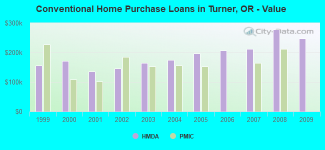
| Home Mortgage Disclosure Act Aggregated Statistics For Year 2009 (Based on 1 partial tract) | ||||||||
| A) FHA, FSA/RHS & VA Home Purchase Loans | B) Conventional Home Purchase Loans | C) Refinancings | G) Loans On Manufactured Home Dwelling (A B C & D) | |||||
|---|---|---|---|---|---|---|---|---|
| Number | Average Value | Number | Average Value | Number | Average Value | Number | Average Value | |
| LOANS ORIGINATED | 1 | $220,980 | 2 | $247,070 | 13 | $244,753 | 1 | $158,390 |
| APPLICATIONS APPROVED, NOT ACCEPTED | 0 | $0 | 0 | $0 | 2 | $214,065 | 0 | $0 |
| APPLICATIONS DENIED | 0 | $0 | 0 | $0 | 5 | $251,434 | 0 | $0 |
| APPLICATIONS WITHDRAWN | 0 | $0 | 0 | $0 | 3 | $215,567 | 0 | $0 |
| FILES CLOSED FOR INCOMPLETENESS | 0 | $0 | 0 | $0 | 1 | $255,790 | 0 | $0 |
Detailed HMDA statistics for the following Tracts: 0027.00
| Private Mortgage Insurance Companies Aggregated Statistics For Year 2008 (Based on 1 partial tract) | ||
| A) Conventional Home Purchase Loans | ||
|---|---|---|
| Number | Average Value | |
| LOANS ORIGINATED | 1 | $211,930 |
| APPLICATIONS APPROVED, NOT ACCEPTED | 0 | $0 |
| APPLICATIONS DENIED | 0 | $0 |
| APPLICATIONS WITHDRAWN | 0 | $0 |
| FILES CLOSED FOR INCOMPLETENESS | 0 | $0 |
Detailed PMIC statistics for the following Tracts: 0027.00

2002 - 2018 National Fire Incident Reporting System (NFIRS) incidents
- Fire incident types reported to NFIRS in Turner, OR
- 25144.0%Outside Fires
- 23441.0%Structure Fires
- 8214.4%Mobile Property/Vehicle Fires
- 40.7%Other
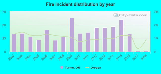 According to the data from the years 2002 - 2018 the average number of fire incidents per year is 34. The highest number of reported fire incidents - 63 took place in 2009, and the least - 1 in 2017. The data has a dropping trend.
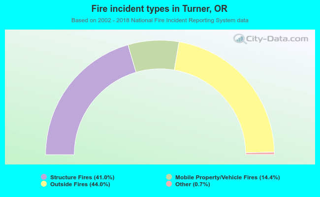 When looking into fire subcategories, the most incidents belonged to: Outside Fires (44.0%), and Structure Fires (41.0%).
| Most common first names in Turner, OR among deceased individuals | ||
| Name | Count | Lived (average) |
|---|---|---|
| William | 23 | 79.1 years |
| Mary | 22 | 85.8 years |
| Robert | 22 | 70.5 years |
| John | 21 | 75.9 years |
| James | 20 | 69.5 years |
| Charles | 13 | 75.3 years |
| Richard | 12 | 67.6 years |
| Hazel | 11 | 81.8 years |
| Albert | 10 | 78.7 years |
| Dorothy | 10 | 78.9 years |
| Most common last names in Turner, OR among deceased individuals | ||
| Last name | Count | Lived (average) |
|---|---|---|
| Smith | 12 | 75.2 years |
| Miller | 11 | 81.2 years |
| Williams | 9 | 73.2 years |
| Mitchell | 8 | 80.3 years |
| White | 8 | 75.5 years |
| Taylor | 7 | 75.8 years |
| Martin | 7 | 79.8 years |
| Nollen | 6 | 70.5 years |
| Anderson | 6 | 80.1 years |
| Lee | 5 | 72.2 years |
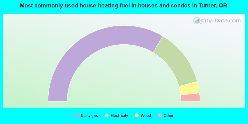
- 67.3%Utility gas
- 24.5%Electricity
- 5.0%Wood
- 2.4%Other fuel
- 0.8%Bottled, tank, or LP gas
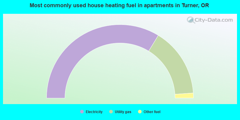
- 67.4%Electricity
- 30.3%Utility gas
- 2.2%Other fuel
Turner compared to Oregon state average:
- Unemployed percentage below state average.
- Black race population percentage below state average.
- Hispanic race population percentage above state average.
- House age below state average.
- Number of college students above state average.