Topsham, Vermont
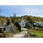
Submit your own pictures of this town and show them to the world
- OSM Map
- Google Map
- MSN Map
Population change since 2000: +2.7%
 |
| Males: 603 | |
| Females: 570 |
| Median resident age: | 41.1 years |
| Vermont median age: | 45.8 years |
Zip codes: 05076.
| Topsham: | $69,551 |
| VT: | $73,991 |
Estimated per capita income in 2022: $32,181 (it was $15,405 in 2000)
Topsham town income, earnings, and wages data
Estimated median house or condo value in 2022: $208,862 (it was $79,700 in 2000)
| Topsham: | $208,862 |
| VT: | $304,700 |
Mean prices in 2022: all housing units: $298,331; detached houses: $318,213; townhouses or other attached units: $371,061; in 2-unit structures: $227,224; in 3-to-4-unit structures: over $1,000,000; in 5-or-more-unit structures: $123,307; mobile homes: $108,182
Detailed information about poverty and poor residents in Topsham, VT
Compare current foreclosures near Topsham, VT:
| Photo | Address | Area | Beds / Baths | Price | Details |
|---|---|---|---|---|---|

|
#1
Scott Hwy
Groton, VT 05046
|
- sq. feet
|
2 baths 3 beds |
$142,500
|
show details |

|
#2
Pike Hill Rd
Corinth, VT 05039
|
- sq. feet
|
- baths - beds |
show details | |

|
#3
Depot St
Haverhill, NH 03765
|
- sq. feet
|
- baths - beds |
show details | |

|
#4
Ayers St Apt 4
Barre, VT 05641
|
- sq. feet
|
- baths - beds |
show details | |

|
#5
Mountain View Dr
Monroe, NH 03771
|
- sq. feet
|
- baths - beds |
show details | |

|
#6
Vt Route 64
Williamstown, VT 05679
|
- sq. feet
|
- baths - beds |
show details | |

|
#7
Erwin Rd
East Corinth, VT 05040
|
- sq. feet
|
- baths - beds |
show details | |

|
#8
Woodchuck Hollow Rd
Washington, VT 05675
|
- sq. feet
|
- baths - beds |
show details | |

|
#9
Vt Rte 214
Plainfield, VT 05667
|
- sq. feet
|
- baths - beds |
show details | |

|
#10
Adams Dr
Woodsville, NH 03785
|
- sq. feet
|
- baths - beds |
show details |
| Photo | Address | Area | Beds / Baths | Price | Details |
|---|---|---|---|---|---|

|
#11
Mountain Rd
Fairlee, VT 05045
|
- sq. feet
|
- baths - beds |
show details | |

|
Check over 1 million property listings on Foreclosure.com!
|
browse all offers | |||

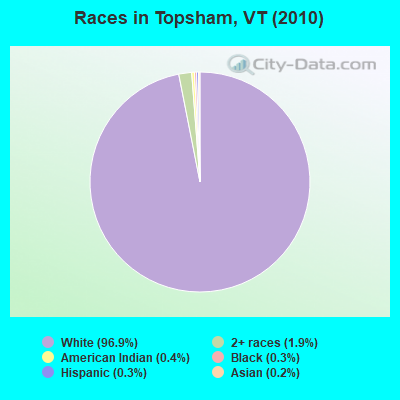
- 1,13796.9%White alone
- 221.9%Two or more races
- 50.4%American Indian alone
- 30.3%Black alone
- 30.3%Hispanic
- 20.2%Asian alone
- 10.09%Native Hawaiian and Other
Pacific Islander alone
Races in Topsham detailed stats: ancestries, foreign born residents, place of birth
According to our research of Vermont and other state lists, there were 9 registered sex offenders living in Topsham, Vermont as of May 17, 2024.
The ratio of all residents to sex offenders in Topsham is 130 to 1.
 Recent articles from our blog. Our writers, many of them Ph.D. graduates or candidates, create easy-to-read articles on a wide variety of topics.
Ancestries: English (31.3%), French (16.1%), United States (15.0%), Irish (13.0%), Scottish (12.0%), German (5.0%).
Current Local Time: EST time zone
Land area: 48.9 square miles.
Population density: 24 people per square mile (very low).
12 residents are foreign born
| This town: | 1.1% |
| Vermont: | 3.8% |
| Topsham town: | 1.6% ($1,247) |
| Vermont: | 2.0% ($2,196) |
Nearest city with pop. 50,000+: Manchester, NH  (88.7 miles , pop. 107,006).
Nearest city with pop. 200,000+: Boston, MA (138.1 miles , pop. 589,141).
Nearest city with pop. 1,000,000+: Bronx, NY (241.5 miles , pop. 1,332,650).
Nearest cities:
), ), ), ), ), Latitude: 44.13 N, Longitude: 72.26 W
Area code commonly used in this area: 802
| Here: | 2.8% |
| Vermont: | 2.0% |
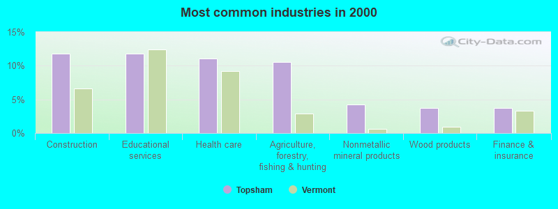
- Construction (11.8%)
- Educational services (11.8%)
- Health care (11.1%)
- Agriculture, forestry, fishing & hunting (10.5%)
- Nonmetallic mineral products (4.3%)
- Wood products (3.7%)
- Finance & insurance (3.7%)
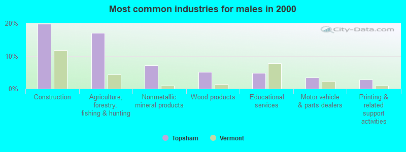
- Construction (19.9%)
- Agriculture, forestry, fishing & hunting (17.1%)
- Nonmetallic mineral products (7.2%)
- Wood products (5.1%)
- Educational services (4.8%)
- Motor vehicle & parts dealers (3.4%)
- Printing & related support activities (2.7%)
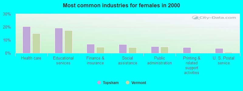
- Health care (20.4%)
- Educational services (19.3%)
- Finance & insurance (7.1%)
- Social assistance (6.7%)
- Public administration (5.2%)
- Printing & related support activities (4.5%)
- U. S. Postal service (3.7%)
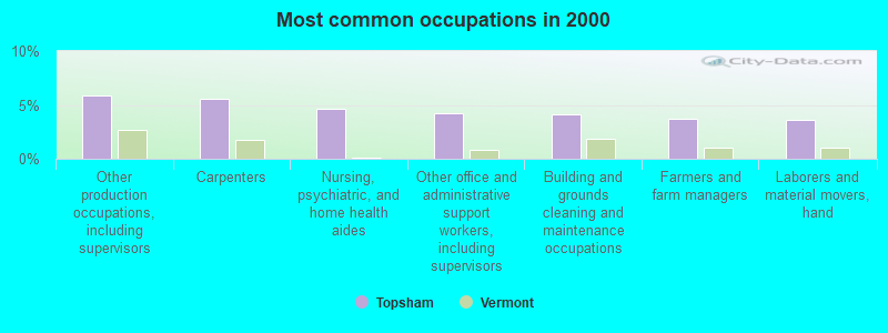
- Other production occupations, including supervisors (5.9%)
- Carpenters (5.5%)
- Nursing, psychiatric, and home health aides (4.6%)
- Other office and administrative support workers, including supervisors (4.3%)
- Building and grounds cleaning and maintenance occupations (4.1%)
- Farmers and farm managers (3.7%)
- Laborers and material movers, hand (3.6%)
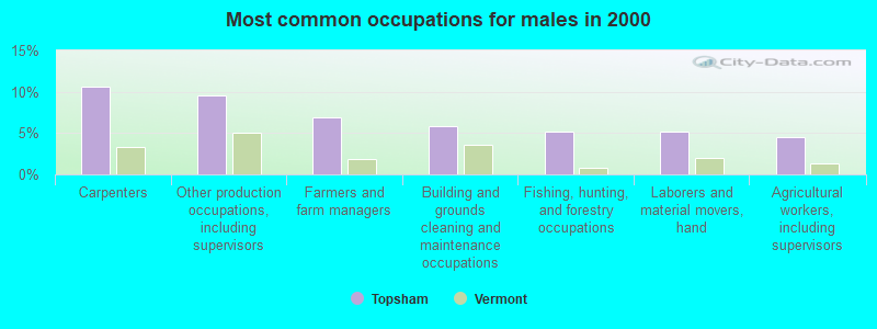
- Carpenters (10.6%)
- Other production occupations, including supervisors (9.6%)
- Farmers and farm managers (6.8%)
- Building and grounds cleaning and maintenance occupations (5.8%)
- Fishing, hunting, and forestry occupations (5.1%)
- Laborers and material movers, hand (5.1%)
- Agricultural workers, including supervisors (4.5%)
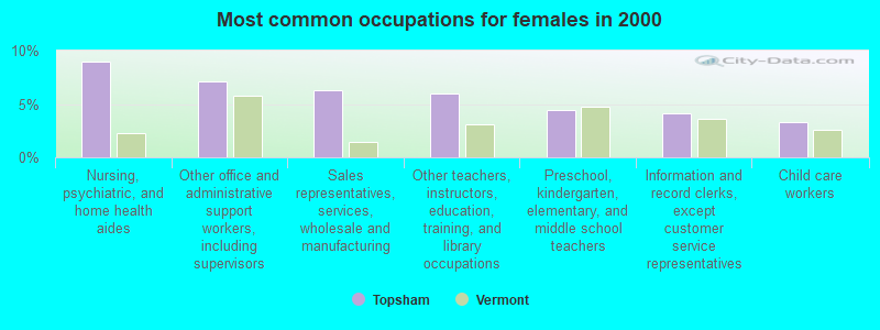
- Nursing, psychiatric, and home health aides (8.9%)
- Other office and administrative support workers, including supervisors (7.1%)
- Sales representatives, services, wholesale and manufacturing (6.3%)
- Other teachers, instructors, education, training, and library occupations (5.9%)
- Preschool, kindergarten, elementary, and middle school teachers (4.5%)
- Information and record clerks, except customer service representatives (4.1%)
- Child care workers (3.3%)
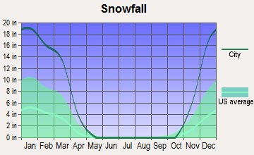
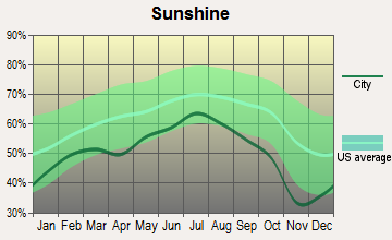
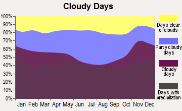
Average climate in Topsham, Vermont
Based on data reported by over 4,000 weather stations


Earthquake activity:
Topsham-area historical earthquake activity is significantly above Vermont state average. It is 71% smaller than the overall U.S. average.On 4/20/2002 at 10:50:47, a magnitude 5.3 (5.3 ML, Depth: 3.0 mi, Class: Moderate, Intensity: VI - VII) earthquake occurred 76.1 miles away from Topsham center
On 4/20/2002 at 10:50:47, a magnitude 5.2 (5.2 MB, 4.2 MS, 5.2 MW, 5.0 MW) earthquake occurred 76.5 miles away from Topsham center
On 10/7/1983 at 10:18:46, a magnitude 5.3 (5.1 MB, 5.3 LG, 5.1 ML) earthquake occurred 104.4 miles away from the city center
On 1/19/1982 at 00:14:42, a magnitude 4.7 (4.5 MB, 4.7 MD, 4.5 LG, Class: Light, Intensity: IV - V) earthquake occurred 54.4 miles away from the city center
On 10/16/2012 at 23:12:25, a magnitude 4.7 (4.7 ML, Depth: 10.0 mi) earthquake occurred 87.9 miles away from the city center
On 6/16/1995 at 12:13:11, a magnitude 3.8 (3.8 LG, Depth: 3.1 mi, Class: Light, Intensity: II - III) earthquake occurred 20.1 miles away from the city center
Magnitude types: regional Lg-wave magnitude (LG), body-wave magnitude (MB), duration magnitude (MD), local magnitude (ML), surface-wave magnitude (MS), moment magnitude (MW)
Natural disasters:
The number of natural disasters in Orange County (26) is a lot greater than the US average (15).Major Disasters (Presidential) Declared: 19
Emergencies Declared: 1
Causes of natural disasters: Floods: 20, Storms: 19, Tropical Storms: 2, Heavy Rain: 1, Hurricane: 1, Ice Storm: 1, Landslide: 1, Wind: 1, Winter Storm: 1, Other: 1 (Note: some incidents may be assigned to more than one category).
Hospitals and medical centers near Topsham:
- GRAFTON COUNTY NURSING HOME (Nursing Home, about 12 miles away; NORTH HAVERHILL, NH)
- HILL ICF/MR (Hospital, about 13 miles away; BARRE, VT)
- ROWAN COURT HEALTH AND REHAB (Nursing Home, about 14 miles away; BARRE, VT)
- COTTAGE HOSPITAL Critical Access Hospitals (about 16 miles away; WOODSVILLE, NH)
- BERLIN HEALTH AND REHAB CTR (Nursing Home, about 16 miles away; BARRE, VT)
Colleges/universities with over 2000 students nearest to Topsham:
- Norwich University (about 21 miles; Northfield, VT; Full-time enrollment: 4,221)
- Dartmouth College (about 30 miles; Hanover, NH; FT enrollment: 6,030)
- Plymouth State University (about 39 miles; Plymouth, NH; FT enrollment: 4,838)
- Middlebury College (about 47 miles; Middlebury, VT; FT enrollment: 3,077)
- Saint Michael's College (about 52 miles; Colchester, VT; FT enrollment: 2,336)
- Community College of Vermont (about 53 miles; Winooski, VT; FT enrollment: 3,394)
- University of Vermont (about 53 miles; Burlington, VT; FT enrollment: 11,566)
Points of interest:
Notable locations in Topsham: Tri-Village Fire Department (A), Tri-village Fire Department (B). Display/hide their locations on the map
Cemeteries: Zion Hill Cemetery (1), West Topsham Cemetery (2), Waits River Cemetery (3), Round Top Cemetery (4), Fellows Cemetery (5), Mills Family Cemetery (6), Huckins-Caldwell Hill Cemetery (7). Display/hide their locations on the map
Reservoir: Norwich Reservoir (A). Display/hide its location on the map
Streams, rivers, and creeks: Powder Spring Brook (A), Perry Brook (B), Levi Brook (C), East Orange Branch (D). Display/hide their locations on the map
Park in Topsham: Pine Mountain Wildlife Management Area (1). Display/hide its location on the map
Birthplace of: William Nutt - Politician.
| This town: | 2.5 people |
| Vermont: | 2.3 people |
| This town: | 70.4% |
| Whole state: | 62.5% |
| This town: | 9.7% |
| Whole state: | 9.2% |
Likely homosexual households (counted as self-reported same-sex unmarried-partner households)
- Lesbian couples: 0.9% of all households
- Gay men: 0.4% of all households
| This town: | 12.8% |
| Whole state: | 9.4% |
| This town: | 2.7% |
| Whole state: | 3.6% |
For population 15 years and over in Topsham:
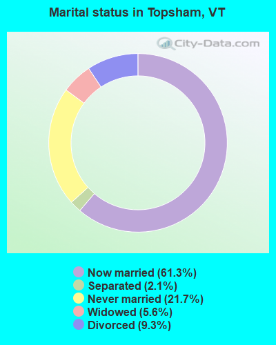
- Never married: 21.7%
- Now married: 61.3%
- Separated: 2.1%
- Widowed: 5.6%
- Divorced: 9.3%
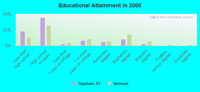
For population 25 years and over in Topsham:
- High school or higher: 76.7%
- Bachelor's degree or higher: 15.0%
- Graduate or professional degree: 4.4%
- Unemployed: 3.6%
- Mean travel time to work (commute): 31.4 minutes
| Here: | 9.9 |
| Vermont average: | 11.7 |
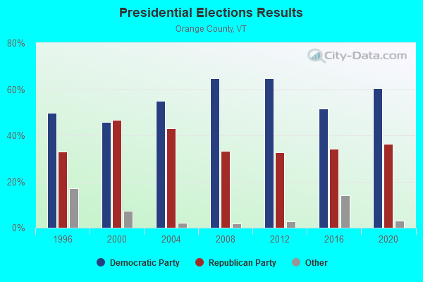
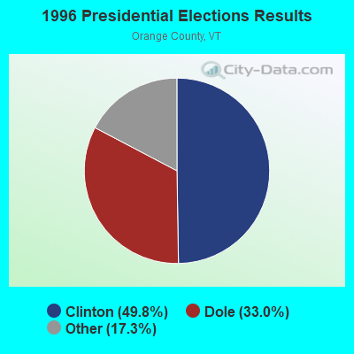
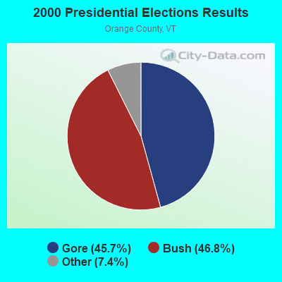
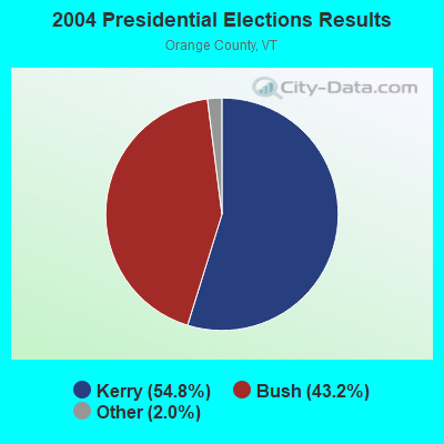
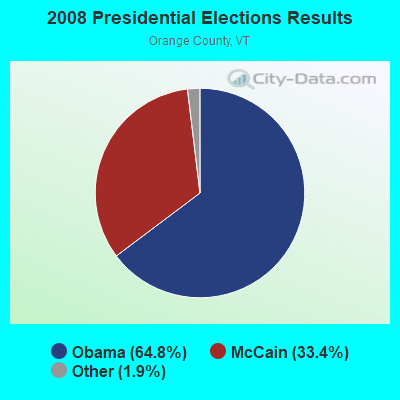
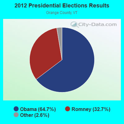
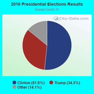
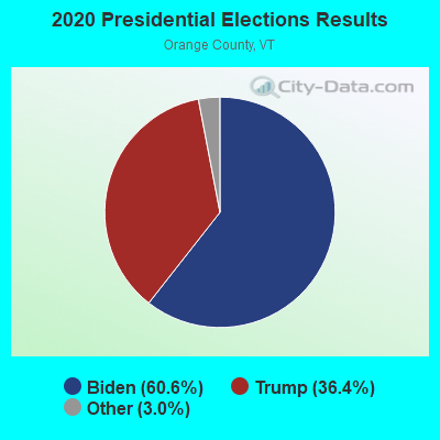
Graphs represent county-level data. Detailed 2008 Election Results
Religion statistics for Topsham, VT (based on Orange County data)
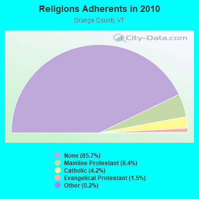
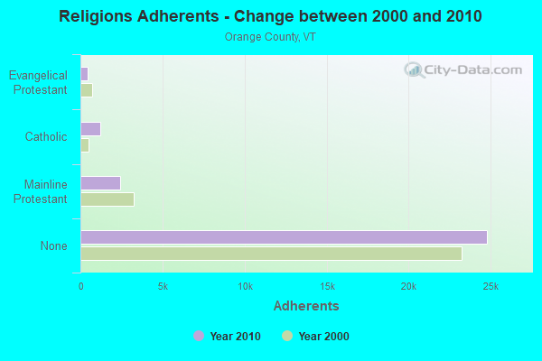
| Religion | Adherents | Congregations |
|---|---|---|
| Mainline Protestant | 2,443 | 33 |
| Catholic | 1,218 | 5 |
| Evangelical Protestant | 438 | 11 |
| Other | 46 | 2 |
| None | 24,791 | - |
Food Environment Statistics:
| Orange County: | 2.76 / 10,000 pop. |
| Vermont: | 3.84 / 10,000 pop. |
| Orange County: | 1.38 / 10,000 pop. |
| Vermont: | 1.95 / 10,000 pop. |
| This county: | 7.60 / 10,000 pop. |
| Vermont: | 6.40 / 10,000 pop. |
| Orange County: | 7.94 / 10,000 pop. |
| Vermont: | 11.52 / 10,000 pop. |
| Orange County: | 6.9% |
| State: | 6.8% |
| This county: | 25.8% |
| Vermont: | 22.3% |
| Orange County: | 12.5% |
| Vermont: | 13.3% |
Strongest AM radio stations in Topsham:
- WTWN (1100 AM; daytime; 5 kW; WELLS RIVER, VT; Owner: PUFFER BROADCASTING, INC.)
- WDEV (550 AM; 5 kW; WATERBURY, VT; Owner: RADIO VERMONT, INC.)
- WCHP (760 AM; 35 kW; CHAMPLAIN, NY; Owner: CHAMPLAIN RADIO, INC.)
- WRKO (680 AM; 50 kW; BOSTON, MA; Owner: ENTERCOM BOSTON LICENSE, LLC)
- WNNZ (640 AM; 50 kW; WESTFIELD, MA; Owner: CLEAR CHANNEL BROADCASTING LICENSES, INC.)
- WSNO (1450 AM; 1 kW; BARRE, VT; Owner: VOX VERMONT, L.L.C)
- WGY (810 AM; 50 kW; SCHENECTADY, NY; Owner: CLEAR CHANNEL BROADCASTING LICENSES, INC.)
- WNTK (1020 AM; 10 kW; NEWPORT, NH; Owner: KOOR COMMUNICATIONS, INC.)
- WCRN (830 AM; 50 kW; WORCESTER, MA; Owner: CARTER BROADCASTING CORPORATION)
- WEEI (850 AM; 50 kW; BOSTON, MA; Owner: ENTERCOM BOSTON LICENSE, LLC)
- WSKI (1240 AM; 1 kW; MONTPELIER, VT; Owner: GALLOWAY COMMUNICATIONS, INC.)
- WPNH (1300 AM; 5 kW; PLYMOUTH, NH; Owner: NORTHEAST COMMUNICATIONS CORPORATION)
- WICY (1490 AM; 50 kW; MALONE, NY; Owner: CARTIER COMMUNICATIONS INC.)
Strongest FM radio stations in Topsham:
- WDOT (95.7 FM; DANVILLE, VT; Owner: MONTPELIER BROADCASTING INC)
- WCMD (89.9 FM; BARRE, VT; Owner: CHRISTIAN MINISTRIES, INC)
- WCVT (101.7 FM; STOWE, VT; Owner: RADIO VERMONT CLASSICS, L.L.C.)
- WPKQ (103.7 FM; NORTH CONWAY, NH; Owner: CITADEL BROADCASTING COMPANY)
- WHOM (94.9 FM; MT. WASHINGTON, NH; Owner: CITADEL BROADCASTING COMPANY)
- WDEV-FM (96.1 FM; WARREN, VT; Owner: RADIO VERMONT, INC.)
- WLKC (103.3 FM; WATERBURY, VT; Owner: RADIO BROADCASTING SERVICES, INC.)
- WVPS (107.9 FM; BURLINGTON, VT; Owner: VERMONT PUBLIC RADIO)
- WEZF (92.9 FM; BURLINGTON, VT; Owner: CAPSTAR TX LIMITED PARTNERSHIP)
- WGMT (97.7 FM; LYNDON, VT; Owner: VERMONT BROADCAST ASSOCIATES, INC.)
- WNCS (104.7 FM; MONTPELIER, VT; Owner: MONTPELIER BROADCASTING, INC.)
- WVFM (105.7 FM; CAMPTON, NH; Owner: DEVON BROADCASTING COMPANY, INC.)
- WEBK (105.3 FM; KILLINGTON, VT; Owner: 6 JOHNSON ROAD LICENSES, INC.)
- WORK (107.1 FM; BARRE, VT; Owner: VOX VERMONT, L.L.C)
- WJJR (98.1 FM; RUTLAND, VT; Owner: 6 JOHNSON ROAD LICENSES, INC.)
- WZRT (97.1 FM; RUTLAND, VT; Owner: CAPSTAR TX LIMITED PARTNERSHIP)
- WGLV (91.7 FM; WOODSTOCK, VT; Owner: CHRISTIAN MINISTRIES INC)
- WHDQ-FM1 (106.1 FM; RUTLAND, VT; Owner: GREAT NORTHERN RADIO, L.L.C.)
- WEVH (91.3 FM; HANOVER, NH; Owner: NEW HAMPSHIRE PUBLIC RADIO INC)
- WMTK (106.3 FM; LITTLETON, NH; Owner: VERMONT BROADCAST ASSOCIATES, INC.)
TV broadcast stations around Topsham:
- WBVT-LP (Channel 39; BURLINGTON, VT; Owner: NYN, LLC)
Topsham fatal accident list:
- National Bridge Inventory (NBI) Statistics
- 17Number of bridges
- 82ft / 25.3mTotal length
- $4,683,000Total costs
- 14,330Total average daily traffic
- 1,056Total average daily truck traffic
- 15,048Total future (year 2027) average daily traffic
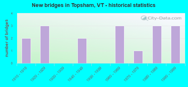
- New bridges - historical statistics
- 21910-1919
- 31920-1929
- 21940-1949
- 31960-1969
- 11970-1979
- 31980-1989
- 31990-1999
FCC Registered Broadcast Land Mobile Towers:
6- Pierson Hill (Lat: 44.116722 Lon: -72.267306), Call Sign: KCZ446,
Assigned Frequencies: 159.195 MHz, 159.195 MHz, Grant Date: 06/23/2022, Expiration Date: 09/14/2032, Registrant: State Of Vermont, 45 State Drive, Watterbury, VT 05671, Phone: (802) 229-0882, Fax: (802) 241-5553, Email:
- Summit Pierson Hill (Lat: 44.116722 Lon: -72.267861), Call Sign: WNAK243,
Assigned Frequencies: 151.475 MHz, Grant Date: 06/30/2014, Expiration Date: 09/07/2024, Registrant: State Of Vermont, 45 State Drive, Watterbury, VT 05671, Phone: (802) 229-0882, Fax: (802) 241-5553, Email:
- Summit Of Pierson Hill 5kms Se Of Junction (Lat: 44.116667 Lon: -72.268056), Type: Tower, Structure height: 27.4 m, Overall height: 30.5 m, Call Sign: KSU618,
Assigned Frequencies: 460.025 MHz, 453.300 MHz, 460.025 MHz, 460.150 MHz, Grant Date: 01/05/2022, Expiration Date: 04/02/2032, Registrant: State Of Vermont, 45 State Drive, Watterbury, VT 05671, Phone: (802) 229-0882, Fax: (802) 241-5615, Email:
- Pierson Hill (Lat: 44.116722 Lon: -72.267861), Call Sign: KXV391,
Assigned Frequencies: 460.150 MHz, 460.275 MHz, 460.300 MHz, Grant Date: 01/26/2023, Expiration Date: 03/28/2033, Registrant: State Of Vermont, 45 State Drive, Watterbury, VT 05671, Phone: (802) 229-0882, Email:
- PIERSON HILL, Summit Of Pierson Hill 5kms Se Of Junction (Lat: 44.116722 Lon: -72.267611), Type: Tower, Structure height: 27.3 m, Call Sign: WQHQ378,
Assigned Frequencies: 453.212 MHz, 453.212 MHz, 453.462 MHz, 453.462 MHz, 453.712 MHz, 453.712 MHz, 453.862 MHz, 453.862 MHz, Grant Date: 07/06/2017, Expiration Date: 10/03/2027, Certifier: Terry Lavalley, Registrant: State Of Vermont, 45 State Drive, Watterbury, VT 05671, Phone: (802) 229-0882, Fax: (407) 302-2293, Email:
- PIERSON HILL, Summit Of Pierson Hill 5kms Se Of Junction (Lat: 44.116722 Lon: -72.267611), Type: Gtower, Structure height: 27.3 m, Call Sign: WQJC670,
Assigned Frequencies: 155.752 MHz, 151.137 MHz, 151.137 MHz, Grant Date: 05/22/2018, Expiration Date: 07/25/2028, Registrant: State Of Vermont, 45 State Drive, Watterbury, VT 05671, Phone: (802) 229-0882, Fax: (802) 241-5553, Email:
FCC Registered Microwave Towers:
5- Pierson Hill, Summit Of Pierson Hill (Lat: 44.116722 Lon: -72.267611), Type: Ltower, Structure height: 27.4 m, Call Sign: WOV83,
Assigned Frequencies: 956.600 MHz, 6815.00 MHz, 6730.00 MHz, 6226.89 MHz, 6315.84 MHz, Grant Date: 09/25/2019, Expiration Date: 12/21/2029, Registrant: State Of Vermont, 45 State Drive, Watterbury, VT 05671, Phone: (802) 229-0882, Fax: (802) 241-5553, Email:
- Topsham MW Pole, 700 Feet North Of Territory Road Adjacent To Velco Transmission Right Of Way (Lat: 44.180750 Lon: -72.288472), Type: Pole, Structure height: 15.2 m, Call Sign: WQWQ345, Licensee ID: L00000470,
Assigned Frequencies: 11225.0 MHz, 11265.0 MHz, 11225.0 MHz, 11265.0 MHz, 11225.0 MHz, 11265.0 MHz, 11225.0 MHz, 11265.0 MHz, 11225.0 MHz, 11265.0 MHz... (+4 more), Grant Date: 10/26/2015, Expiration Date: 10/26/2025, Certifier: Fran Stocker, Registrant: Vtel Wireless, Inc., 354 River Street, Springfield, VT 05156, Phone: (802) 885-7712, Fax: (802) 885-4003, Email:
- Topsham-01, Ben Dexter Road (Lat: 44.116694 Lon: -72.267583), Type: Gtower, Structure height: 27.4 m, Call Sign: WQWQ346, Licensee ID: L00000470,
Assigned Frequencies: 10735.0 MHz, 10775.0 MHz, 10735.0 MHz, 10775.0 MHz, 10735.0 MHz, 10775.0 MHz, 10735.0 MHz, 10775.0 MHz, 10735.0 MHz, 10775.0 MHz... (+4 more), Grant Date: 10/26/2015, Expiration Date: 10/26/2025, Certifier: Fran Stocker, Registrant: Vtel Wireless, Inc., 354 River Street, Springfield, VT 05156, Phone: (802) 885-7712, Fax: (802) 885-4003, Email:
- TOPSHAM, 107 Ben Dexter Rd (Lat: 44.116667 Lon: -72.267500), Type: Gtower, Structure height: 54.9 m, Overall height: 56.4 m, Call Sign: WRNZ775,
Assigned Frequencies: 11015.0 MHz, 11055.0 MHz, Grant Date: 09/14/2021, Expiration Date: 09/14/2031, Cancellation Date: 01/23/2023, Certifier: Mike Hargrove, Registrant: At&t Services, Inc., 208 S. Akard St. 20f, Dallas, TX 75202, Phone: (855) 699-7073, Email:
- TOPSHAM, 107 Ben Dexter Road (Lat: 44.116667 Lon: -72.267500), Type: Gtower, Structure height: 54.9 m, Overall height: 56.1 m, Call Sign: WRXK773,
Assigned Frequencies: 11015.0 MHz, 11055.0 MHz, Grant Date: 05/24/2023, Expiration Date: 05/24/2033, Certifier: Cecil J Mathew, Registrant: At&t Services, Inc., 208 S Akard St, 20f, Dallas, TX 75202, Phone: (855) 699-7073, Email:
FCC Registered Amateur Radio Licenses:
3- Call Sign: AA6TT, Licensee ID: L00311399, Grant Date: 02/05/2002, Expiration Date: 05/05/2012, Cancellation Date: 07/29/2003, Certifier: William H Hein Iii, Registrant: William H Hein Iii, 10 Clark Rd, Topsham, VT 05076-3086
- Call Sign: NT1Y, Previous Call Sign: AA6TT, Licensee ID: L00311399, Grant Date: 07/29/2003, Expiration Date: 07/29/2013, Cancellation Date: 08/26/2008, Certifier: William H Hein Iii, Registrant: William H Hein Iii, 10 Clark Rd, Topsham, VT 05076-3086
- Call Sign: KC1TFW, Licensee ID: L02689238, Grant Date: 07/22/2023, Expiration Date: 07/22/2033, Certifier: Jason P Emerson, Registrant: Jason P Emerson, 518 Powder Spring Rd, Topsham, VT 05076
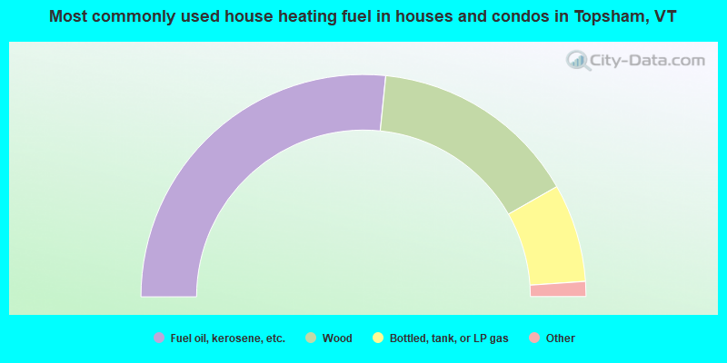
- 53.2%Fuel oil, kerosene, etc.
- 30.3%Wood
- 14.3%Bottled, tank, or LP gas
- 1.1%Utility gas
- 1.1%Electricity
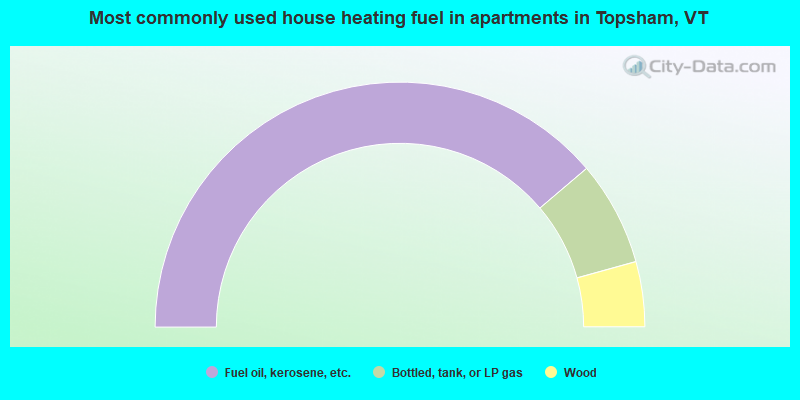
- 77.6%Fuel oil, kerosene, etc.
- 13.8%Bottled, tank, or LP gas
- 8.6%Wood
Topsham compared to Vermont state average:
- Unemployed percentage significantly below state average.
- Black race population percentage significantly below state average.
- Hispanic race population percentage significantly below state average.
- Median age below state average.
- Foreign-born population percentage significantly below state average.
- Renting percentage significantly below state average.
- Length of stay since moving in significantly above state average.
- Number of rooms per house significantly below state average.
- House age significantly below state average.
- Number of college students below state average.
- Percentage of population with a bachelor's degree or higher below state average.

|
Total of 5 patent applications in 2008-2024.