Tonto, Arizona
Submit your own pictures of this place and show them to the world
- OSM Map
- General Map
- Google Map
- MSN Map

| Males: 1,327 | |
| Females: 1,256 |
| Median resident age: | 52.6 years |
| Arizona median age: | 34.2 years |
| Tonto: | $43,767 |
| AZ: | $74,568 |
Estimated per capita income in 2022: $28,758 (it was $15,084 in 2000)
Tonto CCD income, earnings, and wages data
Estimated median house or condo value in 2022: $274,829 (it was $88,800 in 2000)
| Tonto: | $274,829 |
| AZ: | $402,800 |
Mean prices in 2022: all housing units: $283,882; detached houses: $336,072; townhouses or other attached units: $277,466; mobile homes: $139,376; occupied boats, rvs, vans, etc.: $113,020
Detailed information about poverty and poor residents in Tonto, AZ
Compare current foreclosures near Tonto, AZ:
| Photo | Address | Area | Beds / Baths | Price | Details |
|---|---|---|---|---|---|

|
#1
2 Near Rio Verde
Scottsdale, AZ 85262
|
- sq. feet
|
- baths - beds |
$156,000
|
show details |

|
#2
E Anderson Dr
Scottsdale, AZ 85254
|
1,977 sq. feet
|
3 baths 3 beds |
show details | |

|
#3
East Golden Spur Lane
Carefree, AZ 85377
|
3,457 sq. feet
|
5 baths 4 beds |
show details | |

|
#4
E Languid Ln
Carefree, AZ 85377
|
4,340 sq. feet
|
2 baths 3 beds |
show details | |

|
#5
E Desert Vw
Scottsdale, AZ 85255
|
2,954 sq. feet
|
4 baths 4 beds |
show details | |

|
#6
N 108th Pl
Scottsdale, AZ 85259
|
3,697 sq. feet
|
3 baths 4 beds |
show details | |

|
#7
N Escalante Dr
Fountain Hills, AZ 85268
|
2,472 sq. feet
|
3 baths 3 beds |
show details | |

|
#8
E Deer Valley Rd Unit 184
Scottsdale, AZ 85255
|
2,371 sq. feet
|
3 baths 4 beds |
show details | |

|
#9
N Four Peaks Way
Fountain Hills, AZ 85268
|
6,201 sq. feet
|
5 baths - beds |
show details | |

|
#10
N 78th St
Scottsdale, AZ 85266
|
2,031 sq. feet
|
2 baths - beds |
show details |
| Photo | Address | Area | Beds / Baths | Price | Details |
|---|---|---|---|---|---|

|
#11
N 119th Way
Scottsdale, AZ 85259
|
2,544 sq. feet
|
3 baths - beds |
show details | |

|
#12
E Desert Arroyos
Scottsdale, AZ 85255
|
3,654 sq. feet
|
- baths - beds |
show details | |

|
#13
E Westland Rd
Scottsdale, AZ 85262
|
2,016 sq. feet
|
- baths - beds |
show details | |

|
#14
E Thunderbird Rd Apt 1068
Scottsdale, AZ 85260
|
- sq. feet
|
- baths - beds |
show details | |

|
#15
N 92nd St Unit 1082
Scottsdale, AZ 85260
|
- sq. feet
|
- baths - beds |
show details | |

|
#16
E Ironwood Cir
Rio Verde, AZ 85263
|
4,128 sq. feet
|
- baths - beds |
show details | |

|
#17
E Whistling Wind Way
Scottsdale, AZ 85255
|
1,957 sq. feet
|
- baths - beds |
show details | |

|
#18
E Thunderbird Rd Apt 2121
Scottsdale, AZ 85260
|
- sq. feet
|
- baths - beds |
show details | |

|
#19
E Maria Dr
Scottsdale, AZ 85255
|
1,854 sq. feet
|
- baths - beds |
show details | |

|
#20
E Redfield Rd Apt 204
Scottsdale, AZ 85260
|
- sq. feet
|
- baths - beds |
show details |
| Photo | Address | Area | Beds / Baths | Price | Details |
|---|---|---|---|---|---|

|
#21
N Hayden Rd
Scottsdale, AZ 85255
|
827 sq. feet
|
- baths - beds |
show details | |

|
#22
E Carefree Dr
Carefree, AZ 85377
|
- sq. feet
|
- baths - beds |
show details | |

|
#23
N 76th St Apt 2052
Scottsdale, AZ 85255
|
- sq. feet
|
- baths - beds |
show details | |

|
#24
E Redfield Rd Unit 1046
Scottsdale, AZ 85260
|
- sq. feet
|
- baths - beds |
show details | |

|
#25
E Becker Ln
Scottsdale, AZ 85259
|
1,699 sq. feet
|
- baths - beds |
show details | |

|
#26
E Raintree Dr Apt 1159
Scottsdale, AZ 85260
|
- sq. feet
|
- baths - beds |
show details | |

|
#27
N 76th St Apt 2184
Scottsdale, AZ 85255
|
899 sq. feet
|
- baths - beds |
show details | |

|
#28
E Deer Valley Rd Unit 193
Scottsdale, AZ 85255
|
- sq. feet
|
- baths - beds |
show details | |

|
#29
E Thompson Peak Pkwy Apt R3004
Scottsdale, AZ 85255
|
- sq. feet
|
- baths - beds |
show details | |

|
#30
E Hope Dr
Scottsdale, AZ 85259
|
1,360 sq. feet
|
- baths - beds |
show details |
| Photo | Address | Area | Beds / Baths | Price | Details |
|---|---|---|---|---|---|

|
#31
E Redfield Rd Apt 1062
Scottsdale, AZ 85260
|
- sq. feet
|
- baths - beds |
show details | |

|
#32
N 94th St Apt 2017
Scottsdale, AZ 85260
|
- sq. feet
|
- baths - beds |
show details | |

|
#33
N 111th St
Scottsdale, AZ 85259
|
1,249 sq. feet
|
- baths - beds |
show details | |

|
#34
E Sahuaro Dr Apt 2105
Scottsdale, AZ 85259
|
- sq. feet
|
- baths - beds |
show details | |

|
#35
N Frank Lloyd Wright Blvd Apt 1098
Scottsdale, AZ 85260
|
- sq. feet
|
- baths - beds |
show details | |

|
#36
E Anderson Dr Ste 100
Scottsdale, AZ 85255
|
- sq. feet
|
- baths - beds |
show details | |

|
#37
N Scottsdale Rd Ste 103
Scottsdale, AZ 85266
|
- sq. feet
|
- baths - beds |
show details | |

|
#38
N 78th Way
Scottsdale, AZ 85255
|
2,440 sq. feet
|
- baths - beds |
show details | |

|
#39
N 71st Way
Scottsdale, AZ 85266
|
3,236 sq. feet
|
- baths - beds |
show details | |

|
#40
E Gray Rd
Scottsdale, AZ 85260
|
1,978 sq. feet
|
- baths - beds |
show details |
| Photo | Address | Area | Beds / Baths | Price | Details |
|---|---|---|---|---|---|

|
#41
N 76th St Apt 2124
Scottsdale, AZ 85255
|
1,843 sq. feet
|
- baths - beds |
show details | |

|
#42
E Thompson Peak Pkwy Apt R2006
Scottsdale, AZ 85255
|
- sq. feet
|
- baths - beds |
show details | |

|
#43
E Chauncey Ln Apt 2101
Phoenix, AZ 85054
|
- sq. feet
|
- baths - beds |
show details | |

|
#44
E Mountain View Rd Apt 237
Scottsdale, AZ 85258
|
- sq. feet
|
- baths - beds |
show details | |

|
#45
E Mountain View Rd Unit 1005
Scottsdale, AZ 85258
|
- sq. feet
|
- baths - beds |
show details | |

|
#46
E Altadena Ave
Scottsdale, AZ 85260
|
1,802 sq. feet
|
- baths - beds |
show details | |

|
#47
E Corrine Dr
Scottsdale, AZ 85260
|
3,718 sq. feet
|
- baths - beds |
show details | |

|
#48
E Altadena Ave
Scottsdale, AZ 85260
|
1,802 sq. feet
|
- baths - beds |
show details | |

|
#49
N 68th St Apt 1089
Phoenix, AZ 85054
|
- sq. feet
|
- baths - beds |
show details | |

|
Check over 1 million property listings on Foreclosure.com!
|
browse all offers | |||

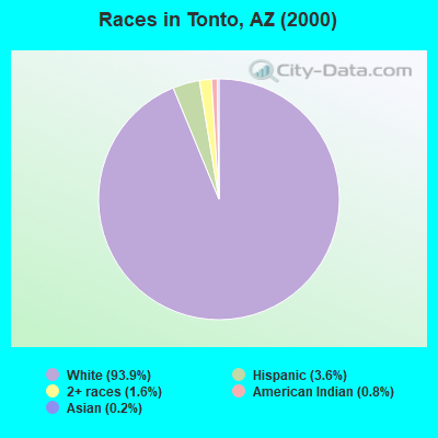
- 2,38493.9%White alone
- 913.6%Hispanic
- 411.6%Two or more races
- 200.8%American Indian alone
- 40.2%Asian alone
 Recent articles from our blog. Our writers, many of them Ph.D. graduates or candidates, create easy-to-read articles on a wide variety of topics.
Current Local Time: MST (no DST) time zone
Land area: 1294.2 square miles.
Population density: 2.0 people per square mile (very low).

| Tonto CCD: | 0.8% ($677) |
| Arizona: | 0.9% ($962) |
Nearest city with pop. 50,000+: North Pinal, AZ (44.7 miles  , pop. 59,965).
Nearest city with pop. 200,000+: Scottsdale, AZ (50.5 miles , pop. 202,705).
Nearest city with pop. 1,000,000+: Phoenix, AZ (61.7 miles , pop. 1,321,045).
Nearest cities:
), )Latitude: 33.93 N, Longitude: 111.12 W
Area code commonly used in this area: 928

| Here: | 4.1% |
| Arizona: | 3.8% |
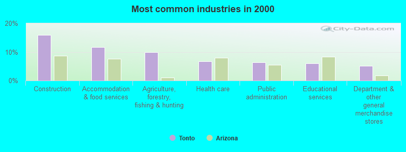
- Construction (15.9%)
- Accommodation & food services (11.8%)
- Agriculture, forestry, fishing & hunting (9.9%)
- Health care (6.7%)
- Public administration (6.3%)
- Educational services (5.9%)
- Department & other general merchandise stores (5.1%)
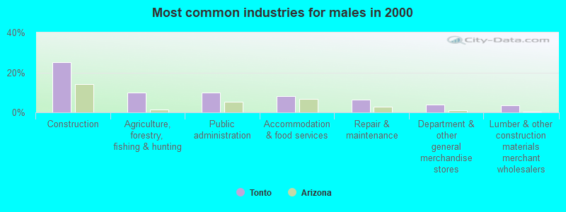
- Construction (25.0%)
- Agriculture, forestry, fishing & hunting (9.9%)
- Public administration (9.9%)
- Accommodation & food services (8.1%)
- Repair & maintenance (6.4%)
- Department & other general merchandise stores (3.7%)
- Lumber & other construction materials merchant wholesalers (3.5%)
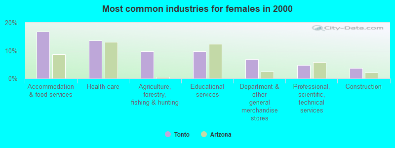
- Accommodation & food services (16.8%)
- Health care (13.7%)
- Agriculture, forestry, fishing & hunting (9.8%)
- Educational services (9.8%)
- Department & other general merchandise stores (7.0%)
- Professional, scientific, technical services (4.7%)
- Construction (3.6%)
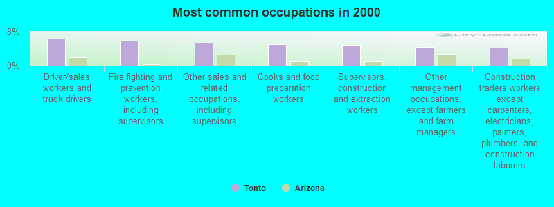
- Driver/sales workers and truck drivers (6.4%)
- Fire fighting and prevention workers, including supervisors (5.8%)
- Other sales and related occupations, including supervisors (5.5%)
- Cooks and food preparation workers (5.1%)
- Supervisors, construction and extraction workers (4.9%)
- Other management occupations, except farmers and farm managers (4.4%)
- Construction traders workers except carpenters, electricians, painters, plumbers, and construction laborers (4.3%)
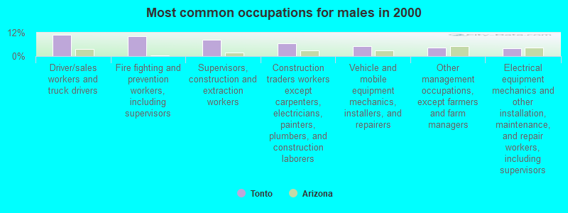
- Driver/sales workers and truck drivers (10.7%)
- Fire fighting and prevention workers, including supervisors (10.1%)
- Supervisors, construction and extraction workers (8.5%)
- Construction traders workers except carpenters, electricians, painters, plumbers, and construction laborers (6.6%)
- Vehicle and mobile equipment mechanics, installers, and repairers (5.0%)
- Other management occupations, except farmers and farm managers (4.3%)
- Electrical equipment mechanics and other installation, maintenance, and repair workers, including supervisors (4.1%)
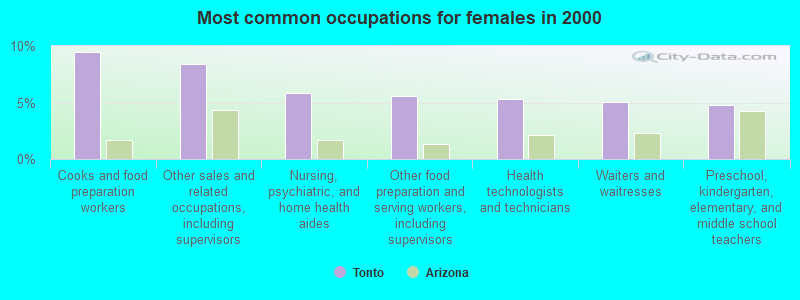
- Cooks and food preparation workers (9.5%)
- Other sales and related occupations, including supervisors (8.4%)
- Nursing, psychiatric, and home health aides (5.9%)
- Other food preparation and serving workers, including supervisors (5.6%)
- Health technologists and technicians (5.3%)
- Waiters and waitresses (5.0%)
- Preschool, kindergarten, elementary, and middle school teachers (4.7%)
Average climate in Tonto, Arizona
Based on data reported by over 4,000 weather stations


(lower is better)
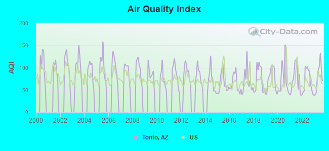
Air Quality Index (AQI) level in 2023 was 78.2. This is about average.
| City: | 78.2 |
| U.S.: | 72.6 |
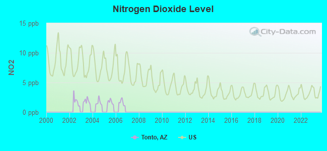
Nitrogen Dioxide (NO2) [ppb] level in 2006 was 1.66. This is significantly better than average. Closest monitor was 19.0 miles away from the city center.
| City: | 1.66 |
| U.S.: | 5.11 |
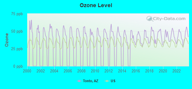
Ozone [ppb] level in 2023 was 45.3. This is worse than average. Closest monitor was 16.9 miles away from the city center.
| City: | 45.3 |
| U.S.: | 33.3 |
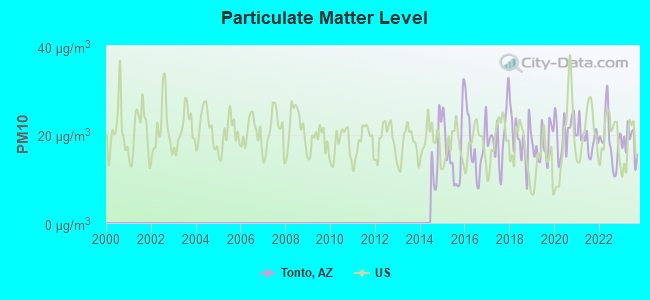
Particulate Matter (PM10) [µg/m3] level in 2023 was 18.2. This is about average. Closest monitor was 24.1 miles away from the city center.
| City: | 18.2 |
| U.S.: | 19.2 |
Earthquake activity:
Tonto-area historical earthquake activity is significantly above Arizona state average. It is 1994% greater than the overall U.S. average.On 6/28/1992 at 11:57:34, a magnitude 7.6 (6.2 MB, 7.6 MS, 7.3 MW, Depth: 0.7 mi, Class: Major, Intensity: VIII - XII) earthquake occurred 310.7 miles away from the city center, causing 3 deaths (1 shaking deaths, 2 other deaths) and 400 injuries, causing $100,000,000 total damage and $40,000,000 insured losses
On 10/16/1999 at 09:46:44, a magnitude 7.4 (6.3 MB, 7.4 MS, 7.2 MW, 7.3 ML) earthquake occurred 306.8 miles away from the city center
On 5/19/1940 at 04:36:40, a magnitude 7.2 (7.2 UK) earthquake occurred 268.4 miles away from Tonto center, causing $33,000,000 total damage
On 12/31/1934 at 18:45:56, a magnitude 7.1 (7.1 UK) earthquake occurred 281.8 miles away from Tonto center
On 10/15/1979 at 23:16:54, a magnitude 7.0 (5.7 MB, 6.9 MS, 7.0 ML, 6.4 MW) earthquake occurred 272.3 miles away from Tonto center
On 7/21/1952 at 11:52:14, a magnitude 7.7 (7.7 UK) earthquake occurred 455.4 miles away from the city center, causing $50,000,000 total damage
Magnitude types: body-wave magnitude (MB), local magnitude (ML), surface-wave magnitude (MS), moment magnitude (MW)
Natural disasters:
The number of natural disasters in Gila County (19) is greater than the US average (15).Major Disasters (Presidential) Declared: 12
Emergencies Declared: 1
Causes of natural disasters: Floods: 10, Storms: 9, Fires: 6, Flash Flood: 1, Heavy Rain: 1, Hurricane: 1, Tornado: 1, Winter Storm: 1, Other: 1 (Note: some incidents may be assigned to more than one category).
Colleges/universities with over 2000 students nearest to Tonto:
- Scottsdale Community College (about 53 miles; Scottsdale, AZ; Full-time enrollment: 6,030)
- Arizona State University-Polytechnic (about 54 miles; Mesa, AZ; FT enrollment: 3,311)
- Le Cordon Bleu College of Culinary Arts-Scottsdale (about 55 miles; Scottsdale, AZ; FT enrollment: 2,123)
- Paradise Valley Community College (about 55 miles; Phoenix, AZ; FT enrollment: 5,259)
- Arizona State University-Skysong (about 57 miles; Scottsdale, AZ; FT enrollment: 5,445)
- Mesa Community College (about 58 miles; Mesa, AZ; FT enrollment: 14,726)
- Chandler-Gilbert Community College (about 59 miles; Chandler, AZ; FT enrollment: 8,047)
Points of interest:
Notable locations in Tonto: Owlhead (A), A-Cross Adminstrative Site (B), Bouquet Ranch (C), Brown Ranch (D), Brunson Ranch (E), Buzzard Roost Camp (F), Circle Ranch (G), Conway Corral (H), Conway Ranch (I), Cook Ranch (J), Dupont Cabin (K), Ellinwood Ranch (L), Ellison Ranch (M), Flying H Ranch (N), Flying V Ranch (O), Flying W Ranch (P), Fred Pranty Cabin (Q), Three Bar Cabin (R), Gun Creek Corral (S), Horse Camp (T). Display/hide their locations on the map
Church in Tonto: Punkin Center Baptist Church (A). Display/hide its location on the map
Cemetery: H Four Cemetery (1). Display/hide its location on the map
Reservoirs: Fred Tank (A), Baker Tank (B), Bench Tank (C), Big Ridge Tank (D), Big Turkey Tank (E), Blackjack Tank (F), Board Tank (G), Breadpan Tank (H). Display/hide their locations on the map
Streams, rivers, and creeks: Pocket Creek (A), Tank Creek (B), Rose Creek (C), Chalk Creek (D), Crouch Creek (E), Cellar Creek (F), Hardt Creek (G), East Spear Creek (H), Marsh Creek (I). Display/hide their locations on the map
Parks in Tonto include: Horse Pasture Recreation Area (1), Roosevelt Lake Wildlife Area (2), Three Bar Wildlife Enclosure (3), Buckhorn Mountain Research Natural Area (4). Display/hide their locations on the map
| This place: | 2.1 people |
| Arizona: | 2.6 people |
| This place: | 59.1% |
| Whole state: | 68.2% |
| This place: | 3.2% |
| Whole state: | 6.2% |
Likely homosexual households (counted as self-reported same-sex unmarried-partner households)
- Lesbian couples: 0.3% of all households
- Gay men: 0.6% of all households
| This place: | 16.3% |
| Whole state: | 13.9% |
| This place: | 7.7% |
| Whole state: | 6.2% |
For population 15 years and over in Tonto:
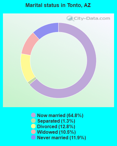
- Never married: 11.9%
- Now married: 64.8%
- Separated: 1.3%
- Widowed: 10.5%
- Divorced: 12.8%
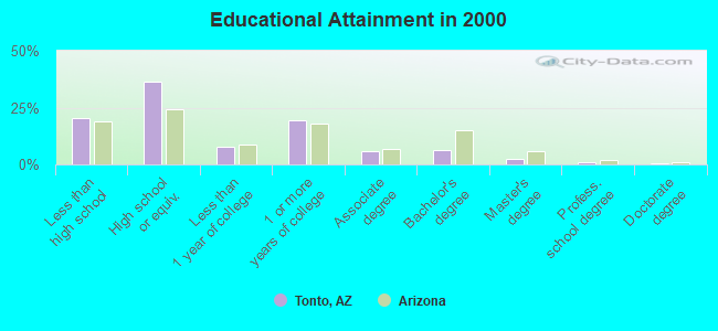
For population 25 years and over in Tonto:
- High school or higher: 79.6%
- Bachelor's degree or higher: 10.4%
- Graduate or professional degree: 4.0%
- Unemployed: 5.1%
- Mean travel time to work (commute): 31.9 minutes
| Here: | 9.5 |
| Arizona average: | 13.1 |
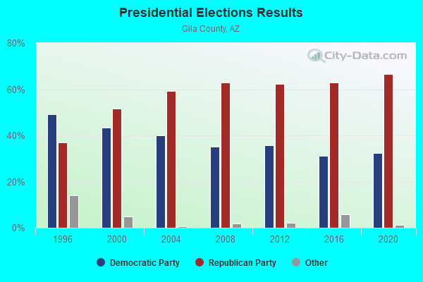
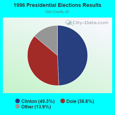
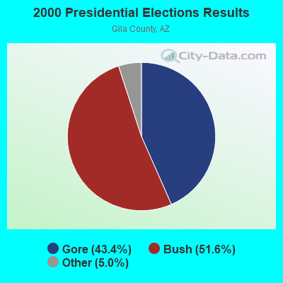
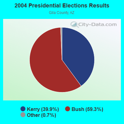

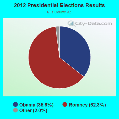
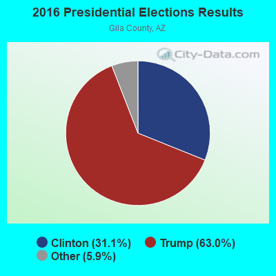

Graphs represent county-level data. Detailed 2008 Election Results
Religion statistics for Tonto, AZ (based on Gila County data)
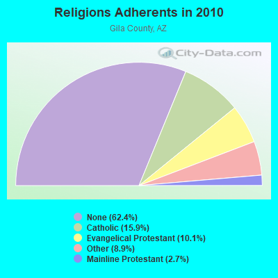
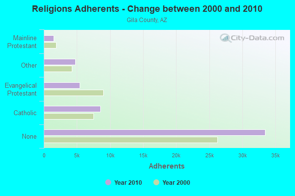
| Religion | Adherents | Congregations |
|---|---|---|
| Catholic | 8,519 | 10 |
| Evangelical Protestant | 5,416 | 54 |
| Other | 4,756 | 17 |
| Mainline Protestant | 1,454 | 11 |
| None | 33,452 | - |
Food Environment Statistics:
| Here: | 1.35 / 10,000 pop. |
| Arizona: | 1.36 / 10,000 pop. |
| Gila County: | 0.19 / 10,000 pop. |
| Arizona: | 0.14 / 10,000 pop. |
| Here: | 0.39 / 10,000 pop. |
| Arizona: | 0.55 / 10,000 pop. |
| This county: | 4.81 / 10,000 pop. |
| Arizona: | 2.47 / 10,000 pop. |
| This county: | 9.82 / 10,000 pop. |
| State: | 6.21 / 10,000 pop. |
| This county: | 11.4% |
| State: | 8.0% |
| Gila County: | 27.1% |
| Arizona: | 22.8% |
| Gila County: | 12.9% |
| Arizona: | 14.2% |
Strongest AM radio stations in Tonto:
- KMIA (710 AM; 50 kW; BLACK CANYON CITY, AZ; Owner: ENTRAVISION HOLDINGS, LLC)
- KFNX (1100 AM; 50 kW; CAVE CREEK, AZ; Owner: NORTH AMERICAN BROADCASTING CO., INC.)
- KMIK (1580 AM; 50 kW; TEMPE, AZ; Owner: ABC, INC.)
- KPXQ (1360 AM; 50 kW; GLENDALE, AZ; Owner: COMMON GROUND BROADCASTING, INC.)
- KFLT (830 AM; 50 kW; TUCSON, AZ; Owner: FAMILY LIFE B/CING SYSTEM, INC.)
- KFNN (1510 AM; 22 kW; MESA, AZ; Owner: CRC BROADCASTING COMPANY, INC.)
- KXEM (1010 AM; 15 kW; TOLLESON, AZ; Owner: JAMES CRYSTAL ENTERPRISES OF PHOENIX, INC.)
- KUAZ (1550 AM; daytime; 50 kW; TUCSON, AZ; Owner: ARIZONA BOARD OF REGENTS)
- KMOG (1420 AM; 2 kW; PAYSON, AZ; Owner: FARRELL ENTERPRISES L.L.C.)
- KTNN (660 AM; 50 kW; WINDOW ROCK, AZ; Owner: THE NAVAJO NATION)
- KTAR (620 AM; 5 kW; PHOENIX, AZ; Owner: EMMIS RADIO LICENSE CORPORATION)
- KFYI (550 AM; 5 kW; PHOENIX, AZ; Owner: AMFM RADIO LICENSES, L.L.C.)
- KKNT (960 AM; 5 kW; PHOENIX, AZ; Owner: COMMON GROUND BROADCASTING, INC)
Strongest FM radio stations in Tonto:
- KAJM (104.3 FM; PAYSON, AZ; Owner: SIERRA H. BROADCASTING, INC.)
- KRXS-FM (97.3 FM; GLOBE, AZ; Owner: LINDA C. POTYKA)
- KVJC (91.9 FM; GLOBE, AZ; Owner: CSN INTERNATIONAL)
- KMRR (100.3 FM; GLOBE, AZ; Owner: HBC LICENSE CORPORATION)
- K294AN (106.7 FM; PAYSON, AZ; Owner: FAMILY LIFE BROADCASTING, INC.)
- KCDX (103.1 FM; FLORENCE, AZ; Owner: DESERT WEST AIR RANCHERS CORPORATION)
- K220GI (91.9 FM; CAMP VERDE, AZ; Owner: CALVARY CHAPEL OF TWIN FALLS, INC.)
- KNRJ (101.1 FM; PAYSON, AZ; Owner: SIERRA H. BROADCASTING,INC.)
- KLVK (89.1 FM; FOUNTAIN HILLS, AZ; Owner: EDUCATIONAL MEDIA FOUNDATION)
- K210CP (89.9 FM; MESA, AZ; Owner: CALVARY CHAPEL OF TWIN FALLS, INC.)
- K220HH (91.9 FM; MESA, AZ; Owner: CALVARY CHAPEL OF TWIN FALLS, INC.)
TV broadcast stations around Tonto:
- KAET (Channel 8; PHOENIX, AZ; Owner: ARIZONA BOARD OF REGENTS)
FCC Registered Antenna Towers:
6- James E McDonald, .5 Miles Se Of The Intersection Of Az Hwy 188 & Punkin Center Rd (Punkin Center) (Lat: 33.868083 Lon: -111.311389), Type: 21.6, Overall height: 18.5 m, Registrant: Alltel Communications, Inc., Aci.Wireless.Regulatory@alltel.Com, , Littl-e Rock, Phone: (501) 905-8555
- James E McDonald, .5 Miles Se Of The Intersection Of Az Hwy 188 & Punkin Center Rd (Punkin Center) (Lat: 33.868083 Lon: -111.311389), Type: 21.6, Overall height: 18.5 m, Registrant: Alltel Communications Inc, Aci.Wireless.Regulatory@alltel.Com, , Littl-e Rock, Phone: (501) 905-8555
- James E McDonald, .5 Miles Se Of The Intersection Of Az Hwy 188 & Punkin Center Rd (Punkin Center) (Lat: 33.868083 Lon: -111.311389), Type: 21.6, Overall height: 18.5 m, Registrant: Alltel Communications, Inc., Aci.Wireless.Regulatory@alltel.Com, , Littl-e Rock, Phone: (501) 905-8555
- James E McDonald, .5 Miles Se Of The Intersection Of Az Hwy 188 & Punkin Center Rd (Punkin Center) (Lat: 33.868083 Lon: -111.311389), Type: 21.6, Overall height: 18.5 m, Registrant: Alltel Communications, Inc., Aci.Wireless.Regulatory@alltel.Com, , Littl-e Rock, Phone: (501) 905-8555
- Michael P Goggin, .5 Miles Se Of The Intersection Of Az Hwy 188 & Punkin Center Rd (Punkin Center) (Lat: 33.868083 Lon: -111.311389), Type: 21.6, Overall height: 18.5 m, Registrant: New Cingular Wireless Pcs, LLC, Mg7268@att.Com, , Washi-ngton, Phone: (202) 457-2055
- Michael P Goggin, .5 Miles Se Of The Intersection Of Az Hwy 188 & Punkin Center Rd (Punkin Center) (Lat: 33.868083 Lon: -111.311389), Type: 21.6, Overall height: 18.5 m, Registrant: At&t Mobility LLC, Mg7268@att.Com, , Washi-ngton, Phone: (202) 457-2055
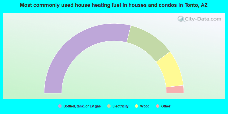
- 57.8%Bottled, tank, or LP gas
- 21.9%Electricity
- 16.7%Wood
- 1.3%Utility gas
- 1.2%Fuel oil, kerosene, etc.
- 0.9%Other fuel
- 0.3%No fuel used
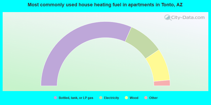
- 63.2%Bottled, tank, or LP gas
- 17.8%Electricity
- 16.1%Wood
- 1.7%No fuel used
- 1.1%Other fuel
Tonto compared to Arizona state average:
- Median household income below state average.
- Unemployed percentage below state average.
- Black race population percentage significantly below state average.
- Hispanic race population percentage significantly below state average.
- Median age significantly above state average.
- Foreign-born population percentage significantly below state average.
- Renting percentage significantly below state average.
- Length of stay since moving in significantly above state average.
- Number of rooms per house significantly below state average.
- House age significantly below state average.
- Number of college students below state average.
- Percentage of population with a bachelor's degree or higher below state average.