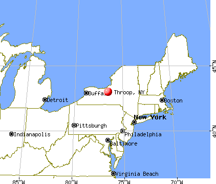
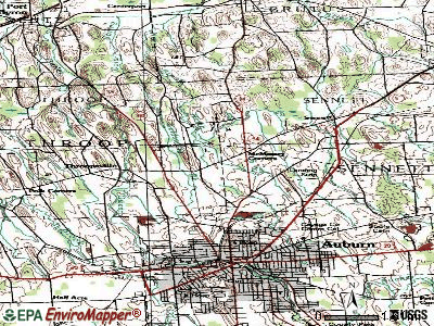
Throop, New York
Submit your own pictures of this town and show them to the world
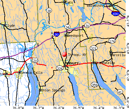
- OSM Map
- General Map
- Google Map
- MSN Map
Population change since 2000: +9.1%
 |
| Males: 990 | |
| Females: 1,000 |
| Median resident age: | 44.4 years |
| New York median age: | 40.7 years |
Zip codes: 13021.
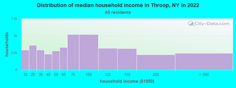
| Throop: | $78,683 |
| NY: | $79,557 |
Estimated per capita income in 2022: $38,915 (it was $19,799 in 2000)
Throop town income, earnings, and wages data
Estimated median house or condo value in 2022: $195,694 (it was $86,200 in 2000)
| Throop: | $195,694 |
| NY: | $400,400 |
Mean prices in 2022: all housing units: $208,264; detached houses: $225,118; townhouses or other attached units: $236,740; in 2-unit structures: $244,571; in 3-to-4-unit structures: $414,744; in 5-or-more-unit structures: $633,100; mobile homes: $69,131
Detailed information about poverty and poor residents in Throop, NY


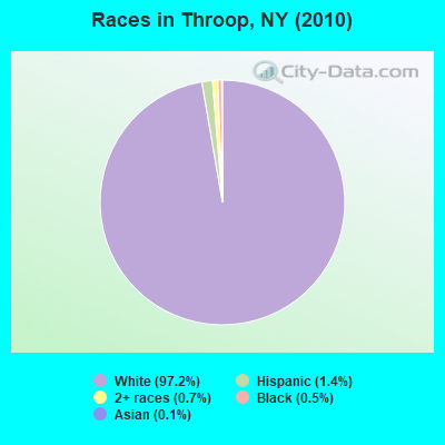
- 1,93497.2%White alone
- 271.4%Hispanic
- 140.7%Two or more races
- 100.5%Black alone
- 20.1%Asian alone
- 10.05%American Indian alone
- 10.05%Native Hawaiian and Other
Pacific Islander alone - 10.05%Other race alone
Races in Throop detailed stats: ancestries, foreign born residents, place of birth
 Recent articles from our blog. Our writers, many of them Ph.D. graduates or candidates, create easy-to-read articles on a wide variety of topics.

 | Bed-Stuy and Bushwick (46 replies) |
| Does anybody miss the old blue/brown token booths??? (0 replies) |
| Is bed stuy a good area to live? (98 replies) |
| Moving to madison between tompkins and throop (bkl) - safe? (14 replies) |
| 65 years old (6 replies) |
| East New York is NYC’s newest ‘hot’ neighborhood (64 replies) |
Latest news from Throop, NY collected exclusively by city-data.com from local newspapers, TV, and radio stations
Ancestries: English (23.4%), Italian (20.7%), Irish (18.0%), German (16.5%), Polish (11.2%), Dutch (6.6%).
Current Local Time: EST time zone
Land area: 18.7 square miles.
Population density: 107 people per square mile (very low).
35 residents are foreign born
| This town: | 1.9% |
| New York: | 20.4% |
| Throop town: | 2.2% ($1,917) |
| New York: | 1.9% ($2,847) |
Nearest city with pop. 50,000+: Syracuse, NY  (24.0 miles , pop. 147,306).
Nearest city with pop. 200,000+: Rochester, NY (52.2 miles , pop. 219,773).
Nearest city with pop. 1,000,000+: Bronx, NY (203.9 miles , pop. 1,332,650).
Nearest cities:
), ), ), ), )Latitude: 42.98 N, Longitude: 76.61 W
Area code commonly used in this area: 315

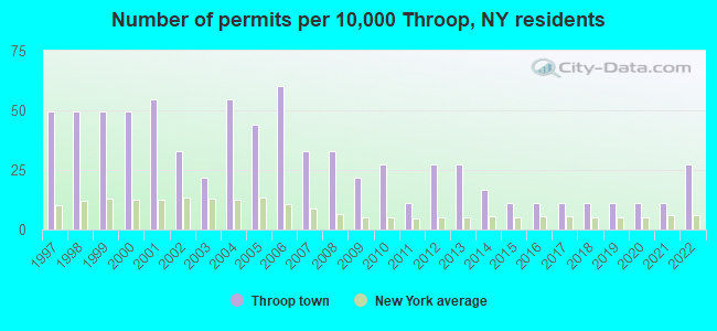
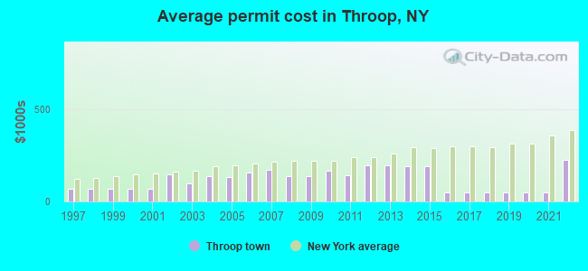
Single-family new house construction building permits:
- 2022: 5 buildings, average cost: $222,600
- 2021: 2 buildings, average cost: $50,000
- 2020: 2 buildings, average cost: $50,000
- 2019: 2 buildings, average cost: $50,000
- 2018: 2 buildings, average cost: $50,000
- 2017: 2 buildings, average cost: $50,000
- 2016: 2 buildings, average cost: $50,000
- 2015: 2 buildings, average cost: $190,500
- 2014: 3 buildings, average cost: $190,500
- 2013: 5 buildings, average cost: $193,400
- 2012: 5 buildings, average cost: $193,400
- 2011: 2 buildings, average cost: $139,500
- 2010: 5 buildings, average cost: $168,000
- 2009: 4 buildings, average cost: $137,000
- 2008: 6 buildings, average cost: $137,000
- 2007: 6 buildings, average cost: $170,500
- 2006: 11 buildings, average cost: $156,700
- 2005: 8 buildings, average cost: $130,500
- 2004: 10 buildings, average cost: $135,900
- 2003: 4 buildings, average cost: $98,400
- 2002: 6 buildings, average cost: $147,500
- 2001: 10 buildings, average cost: $66,400
- 2000: 9 buildings, average cost: $66,400
- 1999: 9 buildings, average cost: $66,400
- 1998: 9 buildings, average cost: $66,400
- 1997: 9 buildings, average cost: $66,400
| Here: | 4.2% |
| New York: | 4.4% |
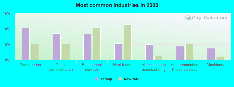
- Construction (10.4%)
- Public administration (8.6%)
- Educational services (8.4%)
- Health care (5.3%)
- Miscellaneous manufacturing (5.0%)
- Accommodation & food services (4.5%)
- Machinery (3.9%)
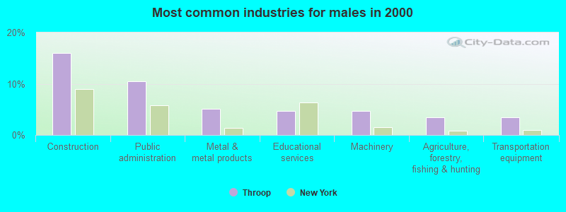
- Construction (16.0%)
- Public administration (10.5%)
- Metal & metal products (5.1%)
- Educational services (4.8%)
- Machinery (4.8%)
- Agriculture, forestry, fishing & hunting (3.4%)
- Transportation equipment (3.4%)
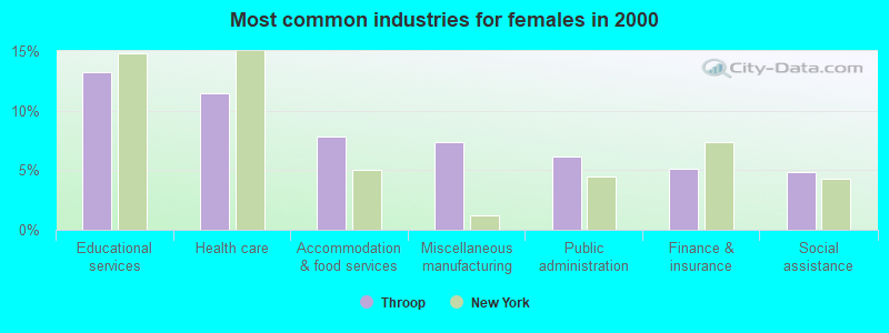
- Educational services (13.2%)
- Health care (11.5%)
- Accommodation & food services (7.8%)
- Miscellaneous manufacturing (7.3%)
- Public administration (6.1%)
- Finance & insurance (5.1%)
- Social assistance (4.9%)
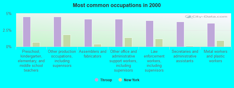
- Preschool, kindergarten, elementary, and middle school teachers (4.5%)
- Other production occupations, including supervisors (4.5%)
- Assemblers and fabricators (4.2%)
- Other office and administrative support workers, including supervisors (4.2%)
- Law enforcement workers, including supervisors (4.0%)
- Secretaries and administrative assistants (3.7%)
- Metal workers and plastic workers (3.5%)
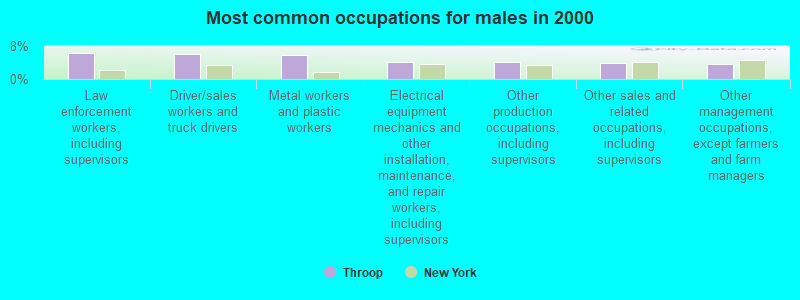
- Law enforcement workers, including supervisors (6.3%)
- Driver/sales workers and truck drivers (6.1%)
- Metal workers and plastic workers (5.9%)
- Electrical equipment mechanics and other installation, maintenance, and repair workers, including supervisors (4.2%)
- Other production occupations, including supervisors (4.2%)
- Other sales and related occupations, including supervisors (3.8%)
- Other management occupations, except farmers and farm managers (3.6%)
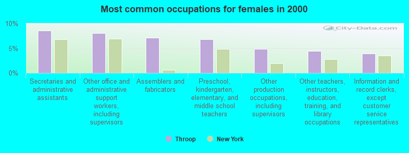
- Secretaries and administrative assistants (8.6%)
- Other office and administrative support workers, including supervisors (8.1%)
- Assemblers and fabricators (7.1%)
- Preschool, kindergarten, elementary, and middle school teachers (6.8%)
- Other production occupations, including supervisors (4.9%)
- Other teachers, instructors, education, training, and library occupations (4.4%)
- Information and record clerks, except customer service representatives (3.9%)
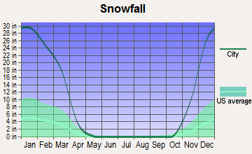
Average climate in Throop, New York
Based on data reported by over 4,000 weather stations


(lower is better)
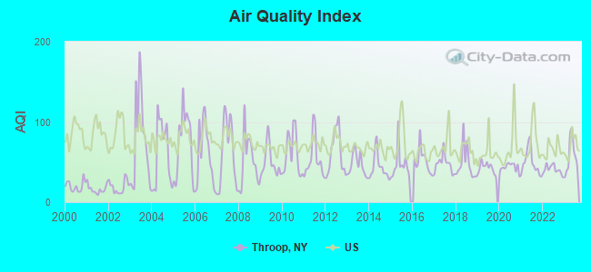
Air Quality Index (AQI) level in 2023 was 57.0. This is better than average.
| City: | 57.0 |
| U.S.: | 72.6 |
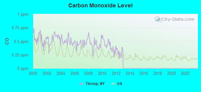
Carbon Monoxide (CO) [ppm] level in 2012 was 0.295. This is about average. Closest monitor was 22.6 miles away from the city center.
| City: | 0.295 |
| U.S.: | 0.251 |

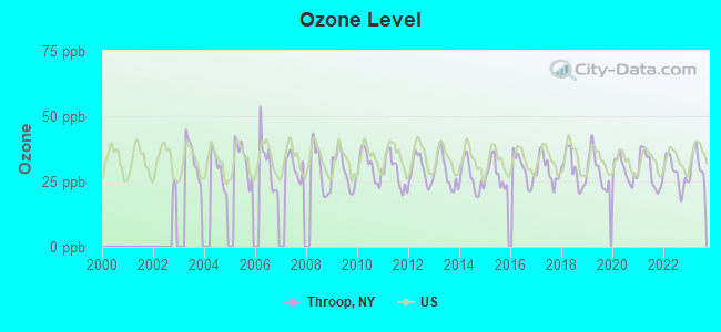
Ozone [ppb] level in 2023 was 31.2. This is about average. Closest monitor was 22.3 miles away from the city center.
| City: | 31.2 |
| U.S.: | 33.3 |
Tornado activity:
Throop-area historical tornado activity is below New York state average. It is 77% smaller than the overall U.S. average.
On 5/2/1983, a category F3 (max. wind speeds 158-206 mph) tornado 13.2 miles away from the Throop town center killed one person and caused between $500,000 and $5,000,000 in damages.
On 5/2/1983, a category F3 tornado 23.3 miles away from the town center caused between $50,000 and $500,000 in damages.
Earthquake activity:
Throop-area historical earthquake activity is significantly above New York state average. It is 68% smaller than the overall U.S. average.On 10/7/1983 at 10:18:46, a magnitude 5.3 (5.1 MB, 5.3 LG, 5.1 ML, Class: Moderate, Intensity: VI - VII) earthquake occurred 132.3 miles away from Throop center
On 4/20/2002 at 10:50:47, a magnitude 5.3 (5.3 ML, Depth: 3.0 mi) earthquake occurred 180.0 miles away from Throop center
On 4/20/2002 at 10:50:47, a magnitude 5.2 (5.2 MB, 4.2 MS, 5.2 MW, 5.0 MW) earthquake occurred 178.2 miles away from the city center
On 9/25/1998 at 19:52:52, a magnitude 5.2 (4.8 MB, 4.3 MS, 5.2 LG, 4.5 MW, Depth: 3.1 mi) earthquake occurred 219.5 miles away from the city center
On 8/23/2011 at 17:51:04, a magnitude 5.8 (5.8 MW, Depth: 3.7 mi) earthquake occurred 357.5 miles away from Throop center
On 1/31/1986 at 16:46:43, a magnitude 5.0 (5.0 MB) earthquake occurred 251.5 miles away from Throop center
Magnitude types: regional Lg-wave magnitude (LG), body-wave magnitude (MB), local magnitude (ML), surface-wave magnitude (MS), moment magnitude (MW)
Natural disasters:
The number of natural disasters in Cayuga County (15) is near the US average (15).Major Disasters (Presidential) Declared: 8
Emergencies Declared: 6
Causes of natural disasters: Floods: 5, Storms: 4, Hurricanes: 2, Blizzard: 1, Heavy Rain: 1, Ice Storm: 1, Landslide: 1, Power Outage: 1, Snow: 1, Tropical Storm: 1, Wind: 1, Other: 2 (Note: some incidents may be assigned to more than one category).
Hospitals and medical centers near Throop:
- CAYUGA COUNTY NURSING HOME (Nursing Home, about 4 miles away; AUBURN, NY)
- FINGER LAKES CENTER FOR LIVING (Nursing Home, about 4 miles away; AUBURN, NY)
- AUBURN COMMUNITY HOSPITAL Acute Care Hospitals (about 4 miles away; AUBURN, NY)
- UNIV DIALYSIS CTR @ AUBURN (Dialysis Facility, about 4 miles away; AUBURN, NY)
- CAYUGA COUNTY CHHA (Home Health Center, about 4 miles away; AUBURN, NY)
- MERCY HEALTH AND REHAB CENTER N H INC (Nursing Home, about 5 miles away; AUBURN, NY)
- AUBURN NURSING HOME (Nursing Home, about 5 miles away; AUBURN, NY)
Colleges/universities with over 2000 students nearest to Throop:
- Cayuga County Community College (about 5 miles; Auburn, NY; Full-time enrollment: 3,141)
- Hobart William Smith Colleges (about 21 miles; Geneva, NY; FT enrollment: 2,476)
- Onondaga Community College (about 22 miles; Syracuse, NY; FT enrollment: 8,920)
- SUNY College of Environmental Science and Forestry (about 25 miles; Syracuse, NY; FT enrollment: 2,044)
- Syracuse University (about 25 miles; Syracuse, NY; FT enrollment: 20,717)
- Le Moyne College (about 27 miles; Syracuse, NY; FT enrollment: 3,041)
- SUNY College at Oswego (about 33 miles; Oswego, NY; FT enrollment: 7,550)
Points of interest:
Notable locations in Throop: Polk Corners (A), Cranebrook Golf Course (B), Cranebrook Tree Farm (C), Throop Fire Department (D). Display/hide their locations on the map
Churches in Throop include: Throop Church of God (A), Throopsville Community Church (B). Display/hide their locations on the map
Cemeteries: Sitzer Cemetery (1), Pine Hill Cemetery (2), Cranebrook Cemetery (3), Throopsville Rural Cemetery (4). Display/hide their locations on the map
| This town: | 2.6 people |
| New York: | 2.6 people |
| This town: | 73.6% |
| Whole state: | 63.5% |
| This town: | 8.3% |
| Whole state: | 6.8% |
Likely homosexual households (counted as self-reported same-sex unmarried-partner households)
- Lesbian couples: 0.3% of all households
- Gay men: 0.0% of all households
| This town: | 3.2% |
| Whole state: | 14.6% |
| This town: | 0.9% |
| Whole state: | 7.4% |
For population 15 years and over in Throop:
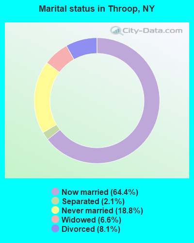
- Never married: 18.8%
- Now married: 64.4%
- Separated: 2.1%
- Widowed: 6.6%
- Divorced: 8.1%
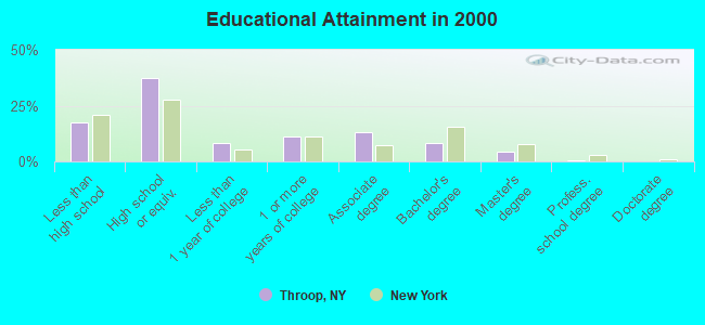
For population 25 years and over in Throop:
- High school or higher: 82.7%
- Bachelor's degree or higher: 13.2%
- Graduate or professional degree: 5.2%
- Unemployed: 5.3%
- Mean travel time to work (commute): 19.5 minutes
| Here: | 8.7 |
| New York average: | 14.2 |
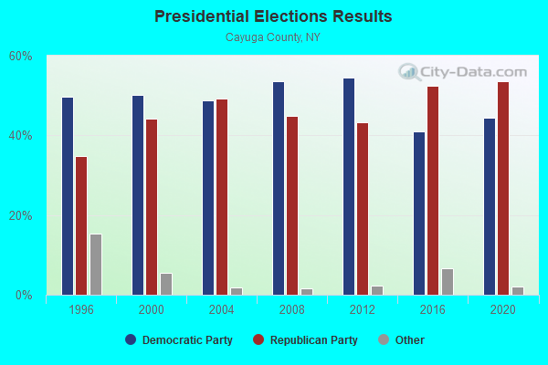
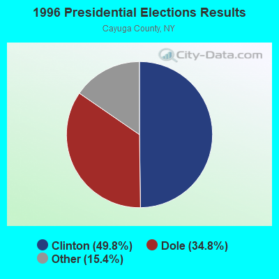
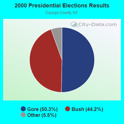
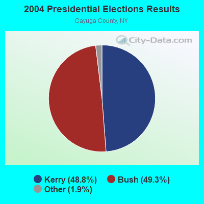
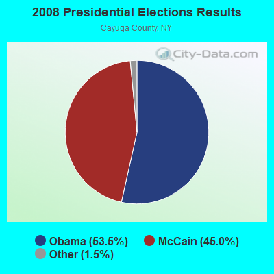
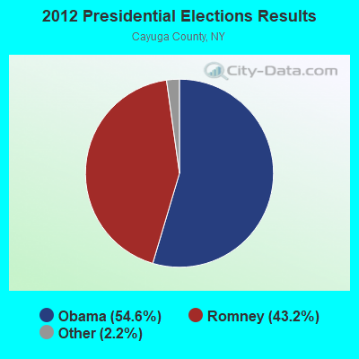
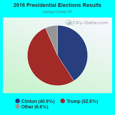
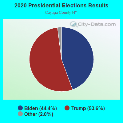
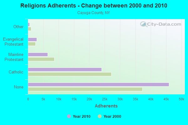
Graphs represent county-level data. Detailed 2008 Election Results
Religion statistics for Throop, NY (based on Cayuga County data)
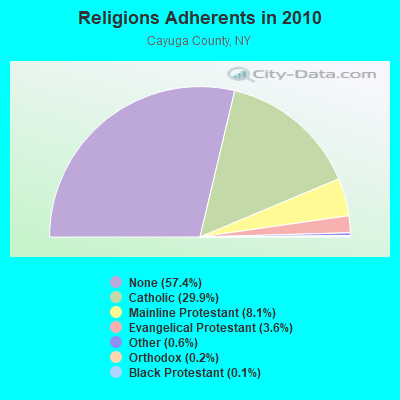
| Religion | Adherents | Congregations |
|---|---|---|
| Catholic | 23,937 | 10 |
| Mainline Protestant | 6,462 | 38 |
| Evangelical Protestant | 2,886 | 31 |
| Other | 502 | 5 |
| Orthodox | 150 | 1 |
| Black Protestant | 119 | 1 |
| None | 45,970 | - |
Food Environment Statistics:
| Cayuga County: | 2.12 / 10,000 pop. |
| New York: | 4.13 / 10,000 pop. |
| Here: | 0.25 / 10,000 pop. |
| New York: | 0.06 / 10,000 pop. |
| Cayuga County: | 0.50 / 10,000 pop. |
| State: | 0.92 / 10,000 pop. |
| This county: | 3.50 / 10,000 pop. |
| New York: | 1.68 / 10,000 pop. |
| This county: | 7.25 / 10,000 pop. |
| New York: | 8.82 / 10,000 pop. |
| Cayuga County: | 8.0% |
| New York: | 8.2% |
| Here: | 25.6% |
| New York: | 23.8% |
| Here: | 12.2% |
| New York: | 15.6% |
Strongest AM radio stations in Throop:
- WWLF (1340 AM; 1 kW; AUBURN, NY; Owner: WOLF RADIO, INC)
- WAUB (1590 AM; 1 kW; AUBURN, NY; Owner: AUBURN BROADCASTING, INC.)
- WSYR (570 AM; 5 kW; SYRACUSE, NY; Owner: CLEAR CHANNEL BROADCASTING LICENSES, INC.)
- WHEN (620 AM; 5 kW; SYRACUSE, NY; Owner: CLEAR CHANNEL BROADCASTING LICENSES, INC.)
- WHAM (1180 AM; 50 kW; ROCHESTER, NY; Owner: CITICASTERS LICENSES, L.P.)
- WSFW (1110 AM; daytime; 1 kW; SENECA FALLS, NY; Owner: AUBURN BROADCASTING, INC.)
- WACK (1420 AM; 5 kW; NEWARK, NY; Owner: PEMBROOK PINES, INC.)
- WFBL (1050 AM; 2 kW; BALDWINSVILLE, NY; Owner: BUCKLEY BROADCASTING CORPORATION)
- WDCW (1390 AM; 5 kW; SYRACUSE, NY; Owner: KIMTRON, INC.)
- WNSS (1260 AM; 5 kW; SYRACUSE, NY; Owner: CITADEL BROADCASTING COMPANY)
- WPIE (1160 AM; 5 kW; TRUMANSBURG, NY; Owner: PEMBROOK PINES ITHACA LTD. N.A.)
- WHCU (870 AM; 5 kW; ITHACA, NY; Owner: EAGLE BROADCASTING COMPANY, INC.)
- WGY (810 AM; 50 kW; SCHENECTADY, NY; Owner: CLEAR CHANNEL BROADCASTING LICENSES, INC.)
Strongest FM radio stations in Throop:
- WPHR (106.9 FM; AUBURN, NY; Owner: CLEAR CHANNEL BROADCASTING LICENSES, INC.)
- WLLW (99.3 FM; SENECA FALLS, NY; Owner: AUBURN BROADCASTING, INC.)
- W251AJ (98.1 FM; MELROSE PARK, NY; Owner: FMX BROADCASTING)
- WMHR (102.9 FM; SYRACUSE, NY; Owner: MARS HILL BROADCASTING CO., INC.)
- WDWN (89.1 FM; AUBURN, NY; Owner: CAYUGA COUNTY COMM. COLLEGE)
- WNYR-FM (98.5 FM; WATERLOO, NY; Owner: LAKE COUNTRY BROADCASTING, INC.)
- WBBS (104.7 FM; FULTON, NY; Owner: CITICASTERS LICENSES, L.P.)
- WFLK (101.7 FM; GENEVA, NY; Owner: MB COMMUNICATIONS, INC.)
- WCOV-FM (93.7 FM; CLYDE, NY; Owner: FAMILY LIFE MINISTRIES, INC.)
- WYYY (94.5 FM; SYRACUSE, NY; Owner: CLEAR CHANNEL BROADCASTING LICENSES, INC.)
- W251AK (98.1 FM; NEDROW, NY; Owner: PATHWAY COMMUNITY RADIO, INC.)
- WCNY-FM (91.3 FM; SYRACUSE, NY; Owner: THE PUB. B/C COUNC. OF CEN. NY, INC.)
- WNTQ (93.1 FM; SYRACUSE, NY; Owner: CITADEL BROADCASTING COMPANY)
- WZUN (102.1 FM; PHOENIX, NY; Owner: GALAXY COMMUNICATIONS, L.P.)
- WYXL (97.3 FM; ITHACA, NY; Owner: EAGLE BROADCASTING COMPANY)
- W278AH (103.5 FM; SYRACUSE, JAMESVILLE, NY; Owner: CALVARY CHAPEL OF THE FINGER LAKES, INC.)
- WCIY (88.9 FM; CANANDAIGUA, NY; Owner: FAMILY LIFE MINISTRIES, INC.)
- WWHT (107.9 FM; SYRACUSE, NY; Owner: CLEAR CHANNEL BROADCASTING LICENSES, INC.)
- WISY (102.3 FM; CANANDAIGUA, NY; Owner: CITICASTERS LICENSES, L.P.)
- WFXF (107.3 FM; SOUTH BRISTOL TOWNSH, NY; Owner: CITICASTERS LICENSES, L.P.)
TV broadcast stations around Throop:
- W48AO (Channel 48; AUBURN, NY; Owner: SONNY PERSAD)
- W54AK (Channel 54; AUBURN, NY; Owner: SONNY PERSAD)
- WCNY-TV (Channel 24; SYRACUSE, NY; Owner: PUBLIC BROADCASTING COUNCIL OF CENTRAL NEW YORK)
- WSYT (Channel 68; SYRACUSE, NY; Owner: WSYT LICENSEE L.P.)
- WSTM-TV (Channel 3; SYRACUSE, NY; Owner: WSTM LICENSE SUBSIDIARY, INC.)
- WIXT-TV (Channel 9; SYRACUSE, NY; Owner: CENTRAL NY NEWS, INC.)
- WNYS-TV (Channel 43; SYRACUSE, NY; Owner: RKM MEDIA, INC.)
- WTVH (Channel 5; SYRACUSE, NY; Owner: WTVH LICENSE, INC.)
- WSPX-TV (Channel 56; SYRACUSE, NY; Owner: PAXSON SYRACUSE LICENSE, INC.)
- W11BP (Channel 11; SYRACUSE, ETC., NY; Owner: RENARD COMMUNICATIONS CORP.)
- W69AN (Channel 69; UNION SPRINGS, ETC., NY; Owner: SONNY PERSAD)
- WTVU-LP (Channel 22; SYRACUSE, NY; Owner: RENARD COMMUNICATIONS CORP.)
- WOBX-LP (Channel 35; SYRACUSE, NY; Owner: METRO TV, INC.)
- WBLZ-LP (Channel 13; SYRACUSE, NY; Owner: RENARD COMMUNICATIONS CORP.)
- W51BA (Channel 51; SYRACUSE, NY; Owner: RENARD COMMUNICATIONS CORP.)
- WSTQ-LP (Channel 14; SYRACUSE, NY; Owner: FEDERAL BROADCASTING COMPANY)
- W30AJ (Channel 30; SYRACUSE, NY; Owner: JOHN MESTER INCOME FAMILY TRUST)
- WMBO-LP (Channel 60; SYRACUSE, ETC., NY; Owner: METRO TV, INC.)
- National Bridge Inventory (NBI) Statistics
- 8Number of bridges
- 39ft / 11.8mTotal length
- $6,395,000Total costs
- 5,654Total average daily traffic
- 565Total average daily truck traffic
- 7,907Total future (year 2036) average daily traffic
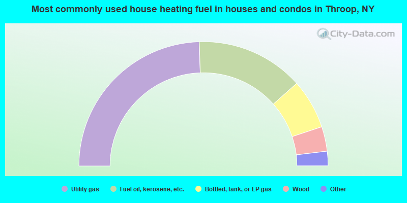
- 48.9%Utility gas
- 28.0%Fuel oil, kerosene, etc.
- 12.9%Bottled, tank, or LP gas
- 6.4%Wood
- 2.7%Electricity
- 0.8%Coal or coke
- 0.3%Other fuel
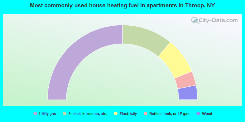
- 50.0%Utility gas
- 21.9%Fuel oil, kerosene, etc.
- 15.6%Electricity
- 6.2%Bottled, tank, or LP gas
- 6.2%Wood
Throop compared to New York state average:
- Median house value below state average.
- Unemployed percentage significantly below state average.
- Black race population percentage significantly below state average.
- Hispanic race population percentage significantly below state average.
- Foreign-born population percentage significantly below state average.
- Renting percentage significantly below state average.
- Length of stay since moving in significantly above state average.
- Number of rooms per house significantly below state average.
- House age significantly below state average.
- Number of college students below state average.
- Percentage of population with a bachelor's degree or higher below state average.