Thornton, Idaho
Submit your own pictures of this place and show them to the world
- OSM Map
- General Map
- Google Map
- MSN Map

| Males: 11,147 | |
| Females: 13,269 |
| Median resident age: | 20.4 years |
| Idaho median age: | 33.2 years |
Zip code: 83440
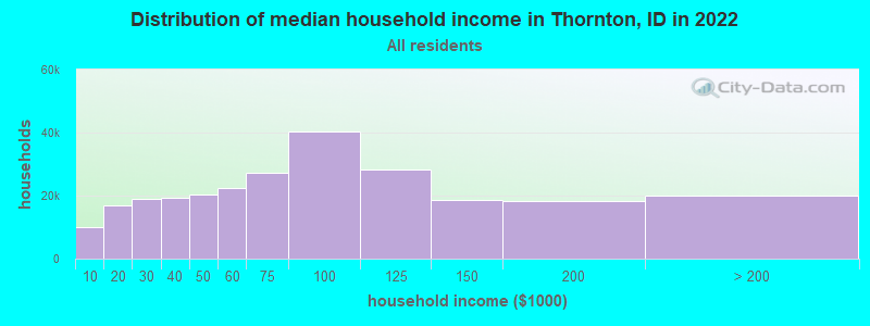
| Thornton: | $46,081 |
| ID: | $72,785 |
Estimated per capita income in 2022: $18,909 (it was $9,398 in 2000)
Thornton CCD income, earnings, and wages data
Estimated median house or condo value in 2022: $401,681 (it was $94,300 in 2000)
| Thornton: | $401,681 |
| ID: | $432,500 |
Mean prices in 2022: all housing units: $411,746; detached houses: $457,859; townhouses or other attached units: $300,526; in 2-unit structures: $261,243; in 3-to-4-unit structures: $254,467; in 5-or-more-unit structures: $145,705; mobile homes: $92,145
Detailed information about poverty and poor residents in Thornton, ID


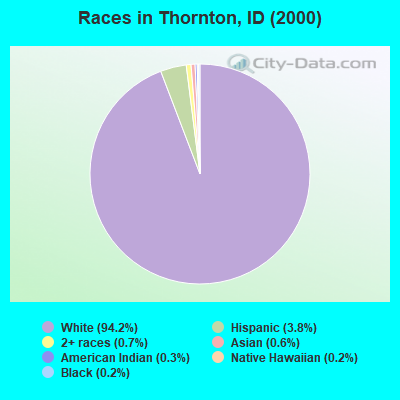
- 16,99394.2%White alone
- 6803.8%Hispanic
- 1270.7%Two or more races
- 1120.6%Asian alone
- 490.3%American Indian alone
- 340.2%Black alone
- 430.2%Native Hawaiian and Other
Pacific Islander alone - 90.05%Other race alone
Races in Thornton detailed stats: ancestries, foreign born residents, place of birth
 Recent articles from our blog. Our writers, many of them Ph.D. graduates or candidates, create easy-to-read articles on a wide variety of topics.
Current Local Time: MST time zone
Elevation: 4860 feet
Land area: 75.4 square miles.
Population density: 324 people per square mile (very low).

| Thornton CCD: | 0.8% ($725) |
| Idaho: | 1.0% ($1,007) |
Nearest city with pop. 50,000+: Idaho Falls, ID  (23.1 miles , pop. 50,730).
Nearest city with pop. 200,000+: West Adams, CO (443.3 miles , pop. 259,628).
Nearest city with pop. 1,000,000+: Phoenix, AZ (709.6 miles , pop. 1,321,045).
Nearest cities:
), ), Latitude: 43.79 N, Longitude: 111.81 W
Area code commonly used in this area: 208

| Here: | 1.9% |
| Idaho: | 3.1% |
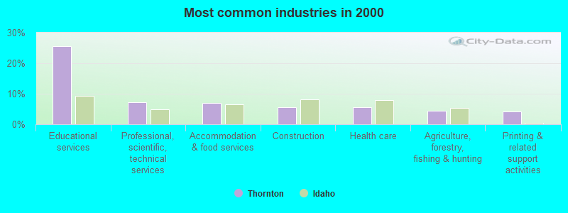
- Educational services (25.6%)
- Professional, scientific, technical services (7.2%)
- Accommodation & food services (7.0%)
- Construction (5.7%)
- Health care (5.5%)
- Agriculture, forestry, fishing & hunting (4.5%)
- Printing & related support activities (4.1%)
- Educational services (21.8%)
- Construction (10.8%)
- Agriculture, forestry, fishing & hunting (7.9%)
- Accommodation & food services (7.2%)
- Professional, scientific, technical services (6.7%)
- Administrative & support & waste management services (3.4%)
- Health care (3.0%)
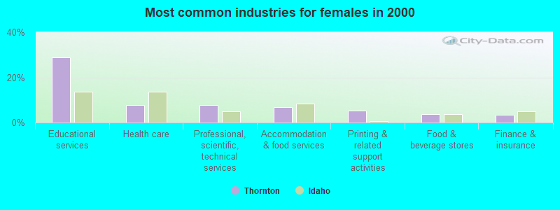
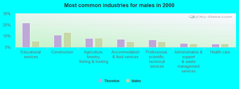
- Educational services (29.0%)
- Health care (7.8%)
- Professional, scientific, technical services (7.6%)
- Accommodation & food services (6.8%)
- Printing & related support activities (5.4%)
- Food & beverage stores (3.6%)
- Finance & insurance (3.4%)
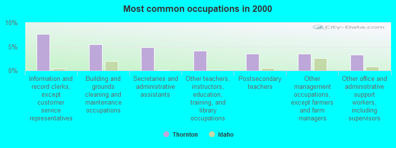
- Information and record clerks, except customer service representatives (7.6%)
- Building and grounds cleaning and maintenance occupations (5.5%)
- Secretaries and administrative assistants (4.9%)
- Other teachers, instructors, education, training, and library occupations (4.1%)
- Postsecondary teachers (3.5%)
- Other management occupations, except farmers and farm managers (3.5%)
- Other office and administrative support workers, including supervisors (3.3%)
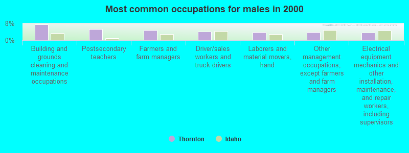
- Building and grounds cleaning and maintenance occupations (7.5%)
- Postsecondary teachers (5.4%)
- Farmers and farm managers (4.9%)
- Driver/sales workers and truck drivers (4.2%)
- Laborers and material movers, hand (3.9%)
- Other management occupations, except farmers and farm managers (3.8%)
- Electrical equipment mechanics and other installation, maintenance, and repair workers, including supervisors (3.8%)
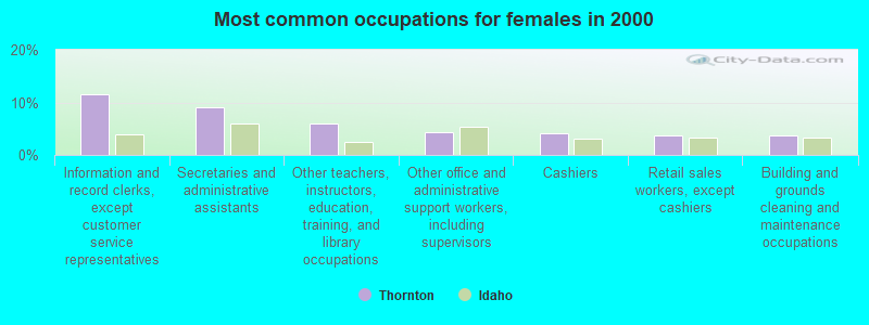
- Information and record clerks, except customer service representatives (11.5%)
- Secretaries and administrative assistants (9.1%)
- Other teachers, instructors, education, training, and library occupations (6.1%)
- Other office and administrative support workers, including supervisors (4.4%)
- Cashiers (4.1%)
- Retail sales workers, except cashiers (3.7%)
- Building and grounds cleaning and maintenance occupations (3.6%)
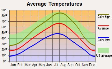
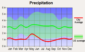
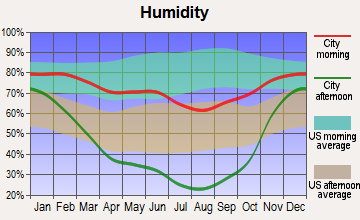
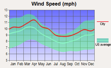
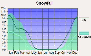
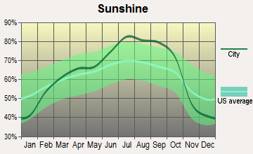
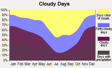
Average climate in Thornton, Idaho
Based on data reported by over 4,000 weather stations
(lower is better)
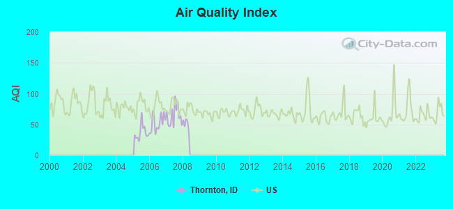
Air Quality Index (AQI) level in 2007 was 64.0. This is about average.
| City: | 64.0 |
| U.S.: | 72.6 |
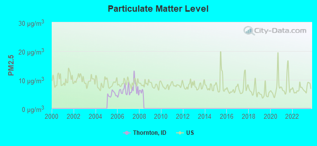
Particulate Matter (PM2.5) [µg/m3] level in 2007 was 7.21. This is about average. Closest monitor was 21.3 miles away from the city center.
| City: | 7.21 |
| U.S.: | 8.11 |
Earthquake activity:
Thornton-area historical earthquake activity is significantly above Idaho state average. It is 1675% greater than the overall U.S. average.On 8/18/1959 at 06:37:13, a magnitude 7.7 (7.7 UK, Class: Major, Intensity: VIII - XII) earthquake occurred 78.8 miles away from the city center, causing $26,000,000 total damage
On 10/28/1983 at 14:06:06, a magnitude 7.3 (6.2 MB, 7.3 MS, 7.0 MW) earthquake occurred 101.2 miles away from Thornton center, causing 2 deaths (2 shaking deaths) and 3 injuries, causing $15,000,000 total damage
On 10/3/1915 at 06:52:48, a magnitude 7.6 (7.6 UK) earthquake occurred 369.7 miles away from the city center
On 3/31/2020 at 23:52:30, a magnitude 6.5 (6.5 MW, Depth: 7.5 mi, Class: Strong, Intensity: VII - IX) earthquake occurred 170.7 miles away from Thornton center
On 6/30/1975 at 18:54:13, a magnitude 6.1 (5.6 MB, 5.9 MS, 6.1 UK, 6.1 ML) earthquake occurred 81.3 miles away from Thornton center
On 3/28/1975 at 02:31:05, a magnitude 6.2 (6.1 MB, 6.0 MS, 6.2 ML) earthquake occurred 127.2 miles away from Thornton center
Magnitude types: body-wave magnitude (MB), local magnitude (ML), surface-wave magnitude (MS), moment magnitude (MW)
Natural disasters:
The number of natural disasters in Madison County (4) is a lot smaller than the US average (15).Major Disasters (Presidential) Declared: 2
Emergencies Declared: 1
Causes of natural disasters: Flood: 1, Hurricane: 1, Other: 2 (Note: some incidents may be assigned to more than one category).
Colleges/universities with over 2000 students nearest to Thornton:
- Brigham Young University-Idaho (about 3 miles; Rexburg, ID; Full-time enrollment: 30,522)
- Idaho State University (about 71 miles; Pocatello, ID; FT enrollment: 10,350)
- Montana State University (about 136 miles; Bozeman, MT; FT enrollment: 12,942)
- Utah State University (about 142 miles; Logan, UT; FT enrollment: 21,131)
- College of Southern Idaho (about 159 miles; Twin Falls, ID; FT enrollment: 5,051)
- Weber State University (about 180 miles; Ogden, UT; FT enrollment: 17,655)
- Western Wyoming Community College (about 201 miles; Rock Springs, WY; FT enrollment: 2,086)
Points of interest:
Notable locations in Thornton: Independence School (A), Rexburg - Madison County Emergency Services Station 2 (B), Rexburg - Madison County Emergency Services Station 1 (C). Display/hide their locations on the map
Church in Thornton: Independence Ward Church (A). Display/hide its location on the map
Cemeteries: Sutton Cemetery (1), Burton Cemetery (2), Beaver Dick Cemetery (3). Display/hide their locations on the map
Streams, rivers, and creeks: Spring Slough (A), Lyons Creek (B). Display/hide their locations on the map
| This place: | 3.7 people |
| Idaho: | 2.7 people |
| This place: | 39.8% |
| Whole state: | 71.9% |
| This place: | 1.2% |
| Whole state: | 4.8% |
Likely homosexual households (counted as self-reported same-sex unmarried-partner households)
- Lesbian couples: 0.1% of all households
- Gay men: 0.1% of all households
| This place: | 41.6% |
| Whole state: | 11.8% |
| This place: | 25.3% |
| Whole state: | 4.6% |
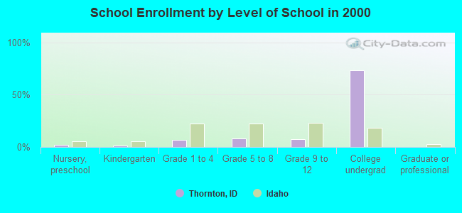
People in group quarters in Thornton in 2000:
- 1,220 people in college dormitories (includes college quarters off campus)
- 76 people in nursing homes
- 59 people in local jails and other confinement facilities (including police lockups)
- 19 people in short-term care, detention or diagnostic centers for delinquent children
- 6 people in other noninstitutional group quarters
For population 15 years and over in Thornton:
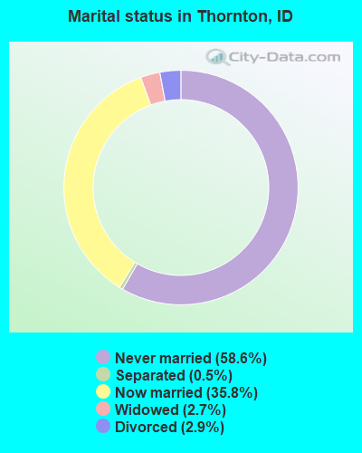
- Never married: 58.6%
- Now married: 35.8%
- Separated: 0.5%
- Widowed: 2.7%
- Divorced: 2.9%
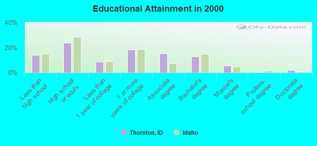
For population 25 years and over in Thornton:
- High school or higher: 86.2%
- Bachelor's degree or higher: 20.6%
- Graduate or professional degree: 7.8%
- Unemployed: 8.8%
- Mean travel time to work (commute): 13.4 minutes
| Here: | 11.4 |
| Idaho average: | 11.1 |
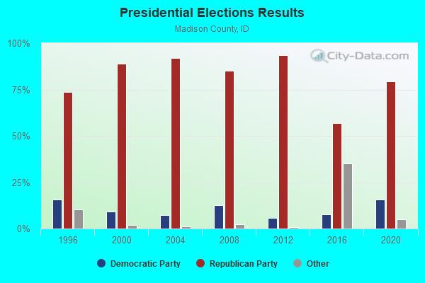
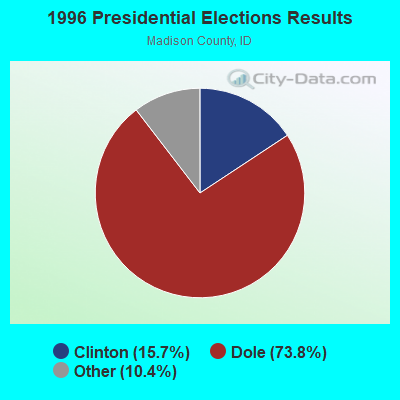
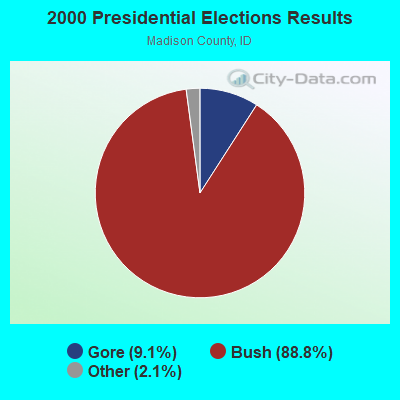
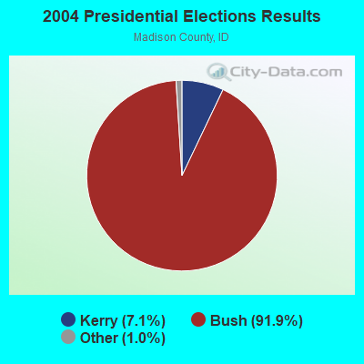
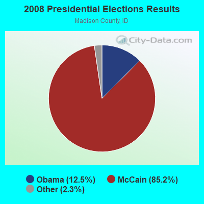
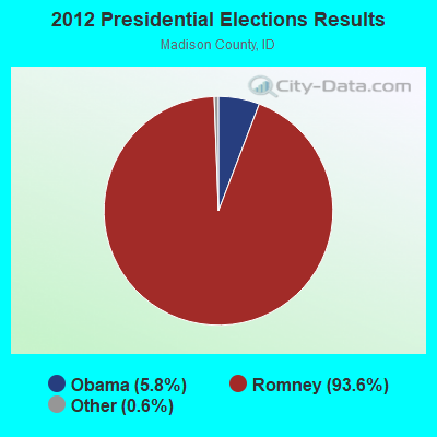
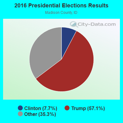
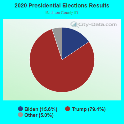
Graphs represent county-level data. Detailed 2008 Election Results
Religion statistics for Thornton, ID (based on Madison County data)
| Religion | Adherents | Congregations |
|---|---|---|
| Other | 37,833 | 157 |
| Catholic | 582 | 1 |
| Evangelical Protestant | 162 | 3 |
| Mainline Protestant | 19 | 1 |
| None | - | - |
Food Environment Statistics:
| Madison County: | 0.81 / 10,000 pop. |
| State: | 1.88 / 10,000 pop. |
| This county: | 2.16 / 10,000 pop. |
| Idaho: | 3.87 / 10,000 pop. |
| Madison County: | 3.79 / 10,000 pop. |
| Idaho: | 7.75 / 10,000 pop. |
| This county: | 5.2% |
| Idaho: | 7.7% |
| Here: | 23.7% |
| Idaho: | 25.7% |
| Here: | 8.2% |
| State: | 11.7% |
Strongest AM radio stations in Thornton:
- KRXK (1230 AM; 1 kW; REXBURG, ID; Owner: PACIFIC EMPIRE COMMUNICATIONS CORP)
- KID (590 AM; 5 kW; IDAHO FALLS, ID; Owner: CITICASTERS LICENSES, L.P.)
- KUPI (980 AM; 5 kW; AMMON, ID; Owner: RAY GROTH OIL COMPANY, INC.)
- KZNI (1260 AM; 5 kW; IDAHO FALLS, ID)
- KZNR (690 AM; 10 kW; BLACKFOOT, ID; Owner: WESTERN COMMUNICATIONS, INC.)
- KBLI (1620 AM; 10 kW; BLACKFOOT, ID; Owner: WESTERN COMMUNICATIONS, INC.)
- KALL (700 AM; 50 kW; NORTH SALT LAKE CITY, UT; Owner: CITICASTERS LICENSES, L.P.)
- KBOI (670 AM; 50 kW; BOISE, ID; Owner: CITADEL BROADCASTING COMPANY)
- KSEI (930 AM; 5 kW; POCATELLO, ID; Owner: PACIFIC EMPIRE COMMUNICATIONS CORP.)
- KIQN (1010 AM; 50 kW; TOOELE, UT)
- KSL (1160 AM; 50 kW; SALT LAKE CITY, UT; Owner: BONNEVILLE HOLDING COMPANY)
- KBRV (790 AM; 5 kW; SODA SPRINGS, ID; Owner: CARIBOU BROADCASTING INC.)
- KERR (750 AM; 50 kW; POLSON, MT; Owner: ANDERSON RADIO BROADCASTING, INC.)
Strongest FM radio stations in Thornton:
- KGTM (98.1 FM; REXBURG, ID; Owner: PACIFIC EMPIRE COMMUNICATIONS CORP)
- KADQ-FM (94.3 FM; REXBURG, ID; Owner: SAND HILL MEDIA CORP.)
- KBYI (100.5 FM; REXBURG, ID; Owner: BRIGHAM YOUNG UNIVERSITY-IDAHO)
- KBJX (107.9 FM; SHELLEY, ID; Owner: PACIFIC EMPIRE COMMUNICATIONS CORP)
- K209BO (89.7 FM; TETONIA, ID; Owner: FAITH COMMUNICATIONS CORPORATION)
- KCHQ (102.1 FM; DRIGGS, ID; Owner: TED W. AUSTIN, JR.)
- KFTZ (103.3 FM; IDAHO FALLS, ID; Owner: WESTERN BROADCASTING, LS, LLC)
- KUPI-FM (99.1 FM; IDAHO FALLS, ID; Owner: RAY GROTH OIL COMPANY, INC.)
- KBYR-FM (91.5 FM; REXBURG, ID; Owner: BRIGHAM YOUNG UNIVERSITY - IDAHO)
- K275AB (102.9 FM; FREEDOM, WY; Owner: LOWER STAR VALLEY TV ASSOCIATION)
- KPLV (105.5 FM; IDAHO FALLS, ID; Owner: WESTERN BROADCASTING, LS, LLC)
- KCVI (101.5 FM; BLACKFOOT, ID; Owner: WESTERN COMMUNICATIONS, INC.)
- KLCE (97.3 FM; BLACKFOOT, ID; Owner: WESTERN COMMUNICATIONS, INC.)
- KID-FM (96.1 FM; IDAHO FALLS, ID; Owner: CITICASTERS LICENSES, L.P.)
- KQEO (107.1 FM; IDAHO FALLS, ID; Owner: SAND HILL MEDIA CORP.)
- K210AT (89.9 FM; ST. ANTHONY, ETC., ID; Owner: FAITH COMMUNICATIONS CORPORATION)
TV broadcast stations around Thornton:
- K13UF (Channel 13; REXBURG, ID; Owner: OREGON TRAIL BROADCASTING COMPANY)
- K59BV (Channel 59; LAVA HOT SPRINGS, ID; Owner: STATE BOARD OF EDUCATION (IEPBS))
- KRXZ-LP (Channel 59; REXBURG, ID; Owner: E-DA-HOE, INC.)
- K12OB (Channel 12; ST. ANTHONY, ID; Owner: OREGON TRAIL BROADCASTING COMPANY)
- K12MA (Channel 12; REXBURG, ETC., ID; Owner: THE POST COMPANY)
- 44.9%Utility gas
- 27.7%Electricity
- 10.2%Bottled, tank, or LP gas
- 8.8%Wood
- 7.1%Fuel oil, kerosene, etc.
- 0.9%Coal or coke
- 0.3%Other fuel
- 63.8%Electricity
- 30.5%Utility gas
- 1.4%Bottled, tank, or LP gas
- 1.3%Fuel oil, kerosene, etc.
- 1.3%Wood
- 1.1%No fuel used
- 0.7%Other fuel
Thornton compared to Idaho state average:
- Median household income below state average.
- Black race population percentage below state average.
- Hispanic race population percentage significantly below state average.
- Median age significantly below state average.
- Foreign-born population percentage significantly below state average.
- Renting percentage significantly below state average.
- Length of stay since moving in significantly above state average.
- Number of rooms per house significantly below state average.
- House age significantly below state average.
- Institutionalized population percentage significantly above state average.
- Number of college students significantly above state average.
Thornton on our top lists:
- #2 on the list of "Top 101 cities with largest percentage of females in industries: printing and related support activities (population 5,000+)"
- #4 on the list of "Top 101 cities with largest percentage of males in occupations: information and record clerks except customer service representatives (population 5,000+)"
- #5 on the list of "Top 101 cities with largest percentage of females in occupations: information and record clerks except customer service representatives (population 5,000+)"
- #11 on the list of "Top 101 cities with largest percentage of males in occupations: postsecondary teachers (population 5,000+)"
- #16 on the list of "Top 101 cities with largest percentage of females in occupations: other teachers and instructors, education, training, and library occupations (population 5,000+)"
- #17 on the list of "Top 101 cities with largest percentage of females in occupations: drafters, engineering, and mapping technicians (population 5,000+)"
- #17 on the list of "Top 101 cities with largest percentage of males in occupations: other teachers and instructors, education, training, and library occupations (population 5,000+)"
- #32 on the list of "Top 101 cities with the most people walking to work (population 5,000+)"
- #41 on the list of "Top 101 cities with largest percentage of males in industries: printing and related support activities (population 5,000+)"
- #53 on the list of "Top 101 cities with the lowest percentage of family households, population 10,000+"
- #58 on the list of "Top 101 cities with largest percentage of females in industries: farm supplies merchant wholesalers (population 5,000+)"
- #60 on the list of "Top 101 cities with largest percentage of females in industries: food (population 5,000+)"
- #72 on the list of "Top 101 cities with largest percentage of females in industries: sporting goods, camera, and hobby and toy stores (population 5,000+)"
- #78 on the list of "Top 101 cities with largest percentage of males in industries: food (population 5,000+)"
- #100 on the list of "Top 101 cities with largest percentage of females in industries: gasoline stations (population 5,000+)"
- #12 (83440) on the list of "Top 101 zip codes with the largest charity contributions deductions as a percentage of AGI in 2012 (pop 5,000+)"
- #50 (83440) on the list of "Top 101 zip codes with the largest percentage of English first ancestries (pop 5,000+)"
- #50 (83440) on the list of "Top 101 zip codes with the largest percentage of Welsh first ancestries (pop 5,000+)"
- #61 (83440) on the list of "Top 101 zip codes with the largest percentage of Danish first ancestries (pop 5,000+)"
- #2 on the list of "Top 101 counties with highest percentage of residents voting for Romney (Republican) in the 2012 Presidential Election"
- #10 on the list of "Top 101 counties with the highest percentage of residents relocating to other counties in 2011"
- #20 on the list of "Top 101 counties with the highest percentage of residents relocating from other counties between 2010 and 2011"
- #28 on the list of "Top 101 counties with the most Other congregations"
- #30 on the list of "Top 101 counties with the lowest number of deaths per 1000 residents 2007-2013"