Estimated median house or condo value in 2022: $550,747 (it was $143,700 in 2000)
Thornton:
$550,747
CA:
$715,900
Mean prices in 2022:all housing units: $555,132; detached houses: $579,147; townhouses or other attached units: $413,977; in 2-unit structures: $846,717; in 3-to-4-unit structures: $323,925; in 5-or-more-unit structures: $223,694; mobile homes: $155,998; occupied boats, rvs, vans, etc.: $9,512March 2022 cost of living index in Thornton: 106.6 (more than average, U.S. average is 100)
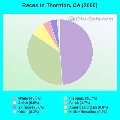
70.2%Native Hawaiian and Other Pacific Islander alone
According to our research of California and other state lists, there was 1 registered sex offender living in Thornton, California as of May 07, 2024. The ratio of all residents to sex offenders in Thornton is 5,446 to 1. The ratio of registered sex offenders to all residents in this city is much lower than the state average.
Recent articles from our blog. Our writers, many of them Ph.D. graduates or candidates, create easy-to-read articles on a wide variety of topics.
Air Quality Index (AQI) level in 2023 was 71.8. This is about average.
City:
71.8
U.S.:
72.6
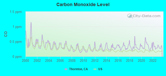
Carbon Monoxide (CO) [ppm] level in 2023 was 0.308. This is worse than average.Closest monitor was 8.3 miles away from the city center.
City:
0.308
U.S.:
0.251
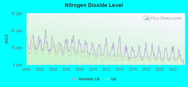
Nitrogen Dioxide (NO2) [ppb] level in 2023 was 3.36. This is significantly better than average.Closest monitor was 11.9 miles away from the city center.
City:
3.36
U.S.:
5.11
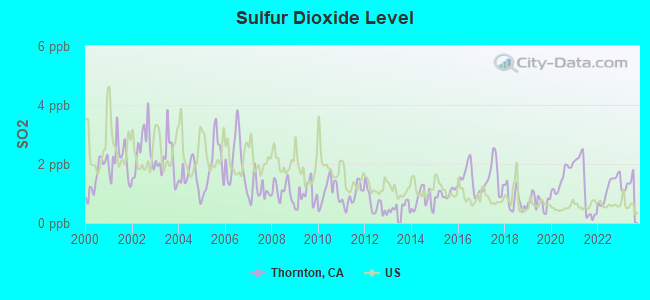
Sulfur Dioxide (SO2) [ppb] level in 2023 was 1.32. This is about average.Closest monitor was 14.1 miles away from the city center.
City:
1.32
U.S.:
1.51
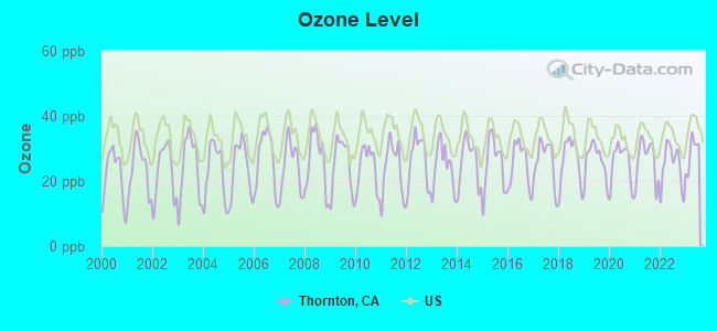
Ozone [ppb] level in 2023 was 28.7. This is about average.Closest monitor was 8.3 miles away from the city center.
City:
28.7
U.S.:
33.3
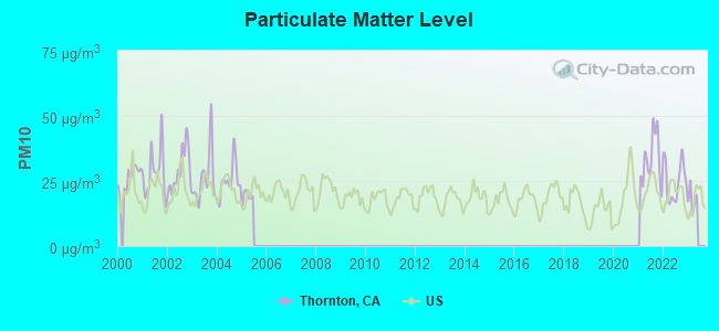
Particulate Matter (PM10) [µg/m3] level in 2022 was 25.0. This is worse than average.Closest monitor was 8.4 miles away from the city center.
City:
25.0
U.S.:
19.2
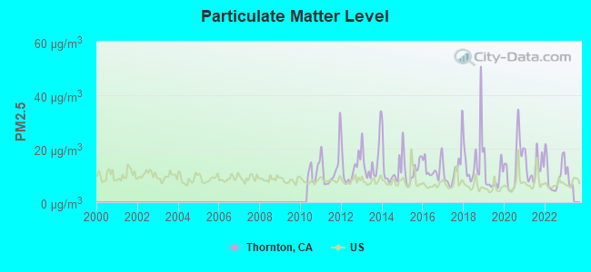
Particulate Matter (PM2.5) [µg/m3] level in 2022 was 10.3. This is worse than average.Closest monitor was 14.5 miles away from the city center.
City:
10.3
U.S.:
8.1
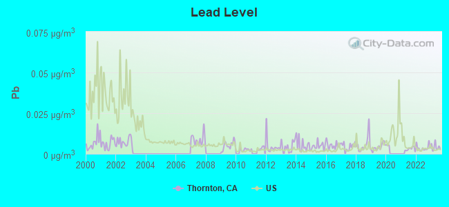
Lead (Pb) [µg/m3] level in 2023 was 0.00414. This is significantly better than average.Closest monitor was 9.4 miles away from the city center.
City:
0.00414
U.S.:
0.00931
Earthquake activity:
Thornton-area historical earthquake activity is significantly above California state average. It is 7881% greater than the overall U.S. average.
On 4/18/1906 at 13:12:21, a magnitude 7.9 (7.9 UK, Class: Major, Intensity: VIII - XII) earthquake occurred 85.5 miles away from Thornton center, causing $524,000,000 total damage On 10/18/1989 at 00:04:15, a magnitude 7.1 (6.5 MB, 7.1 MS, 6.9 MW, 7.0 ML) earthquake occurred 72.9 miles away from the city center, causing 62 deaths (62 shaking deaths) and 3757 injuries, causing $1,305,032,704 total damage On 7/21/1952 at 11:52:14, a magnitude 7.7 (7.7 UK) earthquake occurred 255.4 miles away from the city center, causing $50,000,000 total damage On 11/4/1927 at 13:51:53, a magnitude 7.5 (7.5 UK) earthquake occurred 223.6 miles away from the city center On 10/3/1915 at 06:52:48, a magnitude 7.6 (7.6 UK) earthquake occurred 266.9 miles away from the city center On 12/21/1932 at 06:10:09, a magnitude 7.2 (7.2 UK) earthquake occurred 183.9 miles away from Thornton center Magnitude types: body-wave magnitude (MB), local magnitude (ML), surface-wave magnitude (MS), moment magnitude (MW)
Natural disasters:
The number of natural disasters in San Joaquin County (20) is greater than the US average (15). Major Disasters (Presidential) Declared: 15 Emergencies Declared: 3
Causes of natural disasters: Floods: 13, Storms: 7, Mudslides: 4, Landslides: 3, Winter Storms: 3, Drought: 1, Earthquake: 1, Freeze: 1, Heavy Rain: 1, Hurricane: 1, Tornado: 1, Wind: 1, Other: 2 (Note: some incidents may be assigned to more than one category).
Hospitals and medical centers near Thornton:
LODI MEMORIAL HOSPITAL - WEST (Hospital, about 8 miles away; LODI, CA)
WOODBRIDGE ICF (Hospital, about 8 miles away; WOODBRIDGE, CA)
LODI MEMORIAL HOSPITAL - WEST D/P SNF (Nursing Home, about 8 miles away; LODI, CA)
GAPASIN MANOR ICF DDN #3 (Hospital, about 8 miles away; STOCKTON, CA)
LODI DIALYSIS CENTER (Dialysis Facility, about 8 miles away; LODI, CA)
SHIRLEY'S ICF/DD-H #4 (Hospital, about 9 miles away; STOCKTON, CA)
DUKE FACILITIES, INC #1 (Hospital, about 9 miles away; STOCKTON, CA)
Amtrak stations near Thornton:
15 miles: STOCKTON, CABRAL STATION (STOCKTON, 949 E. CHANNEL ST.) . Services: public payphones.
16 miles: STOCKTON, SAN JOAQUIN ST. (STOCKTON, 735 S. SAN JOAQUIN ST.) . Services: ticket office, fully wheelchair accessible, enclosed waiting area, public restrooms, public payphones, vending machines, free short-term parking, call for car rental service, call for taxi service, public transit connection.
Colleges/universities with over 2000 students nearest to Thornton:
San Joaquin Delta College (about 12 miles; Stockton, CA; Full-time enrollment: 12,167)
University of the Pacific (about 13 miles; Stockton, CA; FT enrollment: 4,999)
Cosumnes River College (about 23 miles; Sacramento, CA; FT enrollment: 9,327)
Los Medanos College (about 25 miles; Pittsburg, CA; FT enrollment: 5,289)
Sacramento City College (about 29 miles; Sacramento, CA; FT enrollment: 15,963)
California State University-Sacramento (about 30 miles; Sacramento, CA; FT enrollment: 22,234)
University of California-Davis (about 33 miles; Davis, CA; FT enrollment: 30,845)
Public elementary/middle school in Thornton:
NEW HOPE ELEMENTARY(Students: 155, Location: 26675 N. SACRAMENTO BLVD., Grades: KG-8)
Notable locations in Thornton: Thornton Rural Fire Protection District (A), Thornton Branch Stockton-San Joaquin County Public Library (B). Display/hide their locations on the map
San Joaquin County has a predicted average indoor radon screening level less than 2 pCi/L (pico curies per liter) - Low Potential
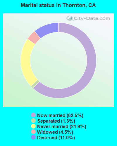
Average household size:
This place:
3.2 people
California:
2.9 people
Percentage of family households:
This place:
77.0%
Whole state:
68.7%
Percentage of households with unmarried partners:
This place:
6.7%
Whole state:
7.2%
Likely homosexual households (counted as self-reported same-sex unmarried-partner households)
Lesbian couples: 0.5% of all households
Gay men: 0.5% of all households
Residents with income below the poverty level in 2009:
This place:
16.4%
Whole state:
14.2%
Residents with income below 50% of the poverty level in 2009:
This place:
3.9%
Whole state:
6.3%
52 people in workers' group living quarters and job corps centers in 2010
7 people in other noninstitutional facilities in 2010
46 people in agriculture workers' dormitories on farms in 2000
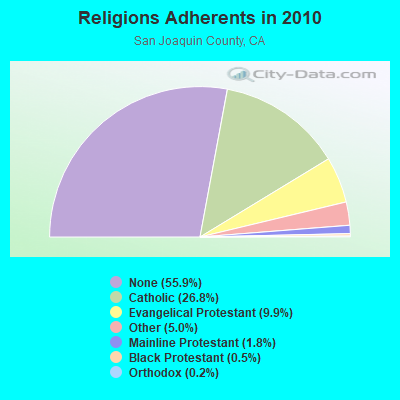
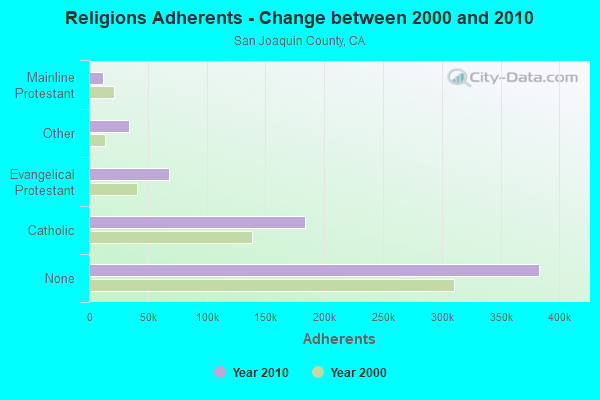
Religion statistics for Thornton, CA (based on San Joaquin County data)
Religion
Adherents
Congregations
Catholic
183,692
18
Evangelical Protestant
67,940
304
Other
33,949
68
Mainline Protestant
12,067
43
Black Protestant
3,251
17
Orthodox
1,368
2
None
383,039
-
Source: Clifford Grammich, Kirk Hadaway, Richard Houseal, Dale E.Jones, Alexei Krindatch, Richie Stanley and Richard H.Taylor. 2012. 2010 U.S.Religion Census: Religious Congregations & Membership Study. Association of Statisticians of American Religious Bodies. Jones, Dale E., et al. 2002. Congregations and Membership in the United States 2000. Nashville, TN: Glenmary Research Center. Graphs represent county-level data
Food Environment Statistics:
Number of grocery stores: 156
Here:
2.34 / 10,000 pop.
California:
2.14 / 10,000 pop.
Number of supercenters and club stores: 3
San Joaquin County:
0.04 / 10,000 pop.
California:
0.04 / 10,000 pop.
Number of convenience stores (no gas): 45
This county:
0.67 / 10,000 pop.
State:
0.62 / 10,000 pop.
Number of convenience stores (with gas): 135
Here:
2.02 / 10,000 pop.
State:
1.49 / 10,000 pop.
Number of full-service restaurants: 349
San Joaquin County:
5.23 / 10,000 pop.
State:
7.42 / 10,000 pop.
Adult diabetes rate:
Here:
7.1%
California:
7.3%
Adult obesity rate:
San Joaquin County:
29.2%
State:
21.3%
Low-income preschool obesity rate:
This county:
16.5%
California:
17.9%
6.18% of this county's 2021 resident taxpayers lived in other counties in 2020 ($75,687 average adjusted gross income)
Here:
6.18%
California average:
5.19%
0.01% of residents moved from foreign countries ($71 average AGI)
San Joaquin County:
0.01%
California average:
0.03%
Top counties from which taxpayers relocated into this county between 2020 and 2021:
Fire House W Main St (Lat: 38.224917 Lon: -121.419944), Call Sign: KMG749, Assigned Frequencies: 154.130 MHz, Grant Date: 02/17/2023, Expiration Date: 05/10/2033, Certifier: Dennis Bitters, Registrant: Ripon Fire Department, 142 S. Stockton Ave., Ripon, CA 95366, Phone: (209) 599-4209, Fax: (209) 599-2847, Email:
Bensons Ferry Telemetry Sta (Lat: 38.255472 Lon: -121.439944), Type: Pole, Structure height: 5 m, Call Sign: KMY44, Assigned Frequencies: 169.575 MHz, Grant Date: 06/27/2003, Expiration Date: 08/31/2013, Cancellation Date: 12/13/2011, Certifier: Glen S Nash, Registrant: State Of California, 601 Sequoia Pacific Blvd, Sacramento, CA 95811-0231, Phone: (916) 657-6153, Fax: (916) 657-9468, Email:
THORNTON, 9899 W Barber Rd (Lat: 38.249056 Lon: -121.438000), Type: Mtower, Structure height: 38.4 m, Overall height: 39 m, Call Sign: WMR934, Assigned Frequencies: 11245.0 MHz, 11245.0 MHz, 11245.0 MHz, 11245.0 MHz, 11405.0 MHz, 11405.0 MHz, 11405.0 MHz, 11405.0 MHz, Grant Date: 02/09/2021, Expiration Date: 02/01/2031, Registrant: Verizon Wireless, 5055 North Point Pkwy, Np2ne Network Engineering, Alpharetta, GA 30022, Phone: (770) 797-1070, Email:
Cpf113 Mp 113.5 170 Ft Of Int Galt & Kile (Lat: 38.219056 Lon: -121.416889), Overall height: 18.3 m, Call Sign: WPNH886, Assigned Frequencies: 941.700 MHz, Grant Date: 09/30/2022, Expiration Date: 10/23/2032, Cancellation Date: 05/05/2023, Registrant: Concentrix, 222 S 15th Street, 505n, Omaha, NE 68102, Phone: (402) 262-4785, Email:
Cpf114 Mp 114.3 945 Ft N Of Int W Oak & Louisa St (Lat: 38.229056 Lon: -121.422444), Overall height: 18.3 m, Call Sign: WPNH887, Assigned Frequencies: 941.700 MHz, Grant Date: 09/30/2022, Expiration Date: 10/23/2032, Cancellation Date: 05/05/2023, Registrant: Concentrix, 222 S 15th Street, 505n, Omaha, NE 68102, Phone: (402) 262-4785, Email:
Cpf123 Mp 122.6 3192 Ft N Of Hein & Point Plesant Rd (Lat: 38.347111 Lon: -121.448833), Overall height: 18.3 m, Call Sign: WPNH889, Assigned Frequencies: 941.700 MHz, Grant Date: 09/30/2022, Expiration Date: 10/23/2032, Cancellation Date: 05/05/2023, Registrant: Concentrix, 222 S 15th Street, 505n, Omaha, NE 68102, Phone: (402) 262-4785, Fax: (402) 233-2025, Email:
Cpf121 Mp 121.3 3767 Ft S Of Hien & Point Pleasant Rd (Lat: 38.328222 Lon: -121.446333), Overall height: 18.3 m, Call Sign: WPNH890, Assigned Frequencies: 941.700 MHz, Grant Date: 09/30/2022, Expiration Date: 10/23/2032, Cancellation Date: 05/05/2023, Registrant: Concentrix, 222 S 15th Street, 505n, Omaha, NE 68102, Phone: (402) 262-4785, Fax: (402) 233-2025, Email:
THORNTON, 4.4 Mi North Of (Lat: 38.283222 Lon: -121.420500), Overall height: 48.8 m, Call Sign: WQP59, Assigned Frequencies: 6197.20 MHz, 6226.90 MHz, 6315.90 MHz, 6345.50 MHz, 6375.20 MHz, 6404.80 MHz, Grant Date: 06/14/1993, Expiration Date: 02/01/2001, Cancellation Date: 03/17/1999, Registrant: Western Union Corporation, One Lake Street, Upper Saddle River, NJ 07458
Call Sign: KA6BTG, Licensee ID: L01110907, Grant Date: 05/22/2017, Expiration Date: 05/22/2027, Certifier: Catherine A Green, Registrant: Catherine A Green, Thornton, CA 95686
Call Sign: W1RAT, Previous Call Sign: KG6UTW, Licensee ID: L00853228, Grant Date: 06/10/2005, Expiration Date: 06/10/2015, Cancellation Date: 04/18/2006, Certifier: Richard L Freeman Jr, Registrant: Richard L Freeman Jr, Thornton, CA 95686
Call Sign: AE6XP, Previous Call Sign: W1RAT, Licensee ID: L00853228, Grant Date: 06/10/2005, Expiration Date: 06/10/2015, Cancellation Date: 05/31/2006, Certifier: Richard L Freeman Jr, Registrant: Richard L Freeman Jr, Thornton, CA 95686
2004 - 2018 National Fire Incident Reporting System (NFIRS) incidents
Based on the data from the years 2004 - 2018 the average number of fire incidents per year is 39. The highest number of reported fire incidents - 88 took place in 2004, and the least - 1 in 2017. The data has a declining trend.
When looking into fire subcategories, the most incidents belonged to: Outside Fires (57.3%), and Mobile Property/Vehicle Fires (28.7%).
Fire incident types reported to NFIRS in Thornton, CA
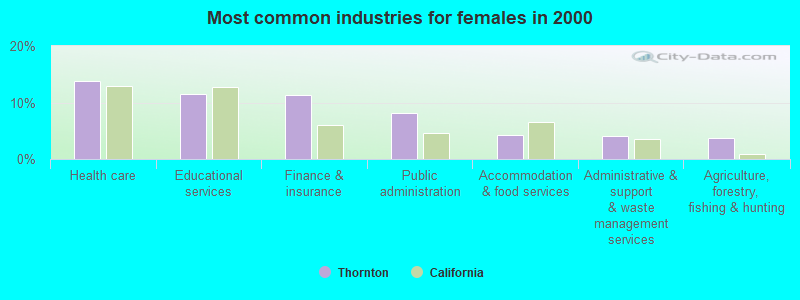
#2 on the list of "Top 101 cities with largest percentage of females in occupations: counselors, social workers, and other community and social service specialists (population 5,000+)"
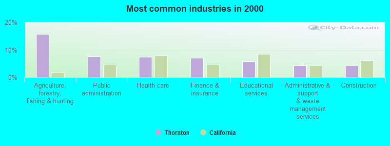
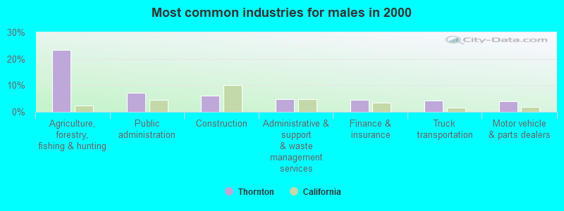
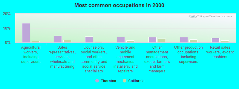
#6 on the list of "Top 101 cities with largest percentage of males in occupations: agricultural workers including supervisors (population 5,000+)"
#6 on the list of "Top 101 cities with largest percentage of females in industries: music stores (population 5,000+)"
#8 on the list of "Top 101 cities with largest percentage of males in occupations: counselors, social workers, and other community and social service specialists (population 5,000+)"
#12 on the list of "Top 101 cities with largest percentage of females in industries: building material and garden equipment and supplies dealers (population 5,000+)"
#15 on the list of "Top 101 cities with largest percentage of females in occupations: other health diagnosing and treating practitioners and technical occupations (population 5,000+)"
#16 on the list of "Top 101 cities with largest percentage of females in industries: sewing, needlework, and piece goods stores (population 5,000+)"
#18 on the list of "Top 101 cities with largest percentage of males in occupations: other transportation workers (population 5,000+)"
#23 on the list of "Top 101 cities with largest percentage of females in occupations: agricultural workers including supervisors (population 5,000+)"
#27 on the list of "Top 101 cities with largest percentage of females in industries: other direct selling establishments (population 5,000+)"
#34 on the list of "Top 101 cities with largest percentage of females in industries: drugs, sundries, and chemical and allied products merchant wholesalers (population 5,000+)"
#55 on the list of "Top 101 cities with largest percentage of females in industries: food (population 5,000+)"
#55 on the list of "Top 101 cities with largest percentage of females in industries: petroleum and petroleum products merchant wholesalers (population 5,000+)"
#61 on the list of "Top 101 cities with largest percentage of males in industries: motor vehicles, parts and supplies merchant wholesalers (population 5,000+)"
#66 on the list of "Top 101 cities with largest percentage of males in industries: agriculture, forestry, fishing and hunting (population 5,000+)"
#76 on the list of "Top 101 cities with largest percentage of males in industries: motor vehicle and parts dealers (population 5,000+)"
#81 on the list of "Top 101 cities with largest percentage of males in industries: beverage and tobacco products (population 5,000+)"
#87 on the list of "Top 101 cities with the largest percentage of people in agriculture workers' dormitories on farms (population 1,000+)"
#89 on the list of "Top 101 cities with largest percentage of males in industries: food (population 5,000+)"
#95 on the list of "Top 101 cities with largest percentage of females in industries: gasoline stations (population 5,000+)"
#12 on the list of "Top 101 counties with the highest lead air pollution readings in 2012 (µg/m3)"
#16 on the list of "Top 101 counties with the lowest lead air pollution readings in 2012 (µg/m3)"
#31 on the list of "Top 101 counties with the highest Particulate Matter (PM2.5) Annual air pollution readings in 2012 (µg/m3)"
#38 on the list of "Top 101 counties with the highest ground withdrawal of fresh water for public supply"
#46 on the list of "Top 101 counties with the lowest Ozone (1-hour) air pollution readings in 2012 (ppm)"


 Recent articles from our blog. Our writers, many of them Ph.D. graduates or candidates, create easy-to-read articles on a wide variety of topics.
 (8.5 miles


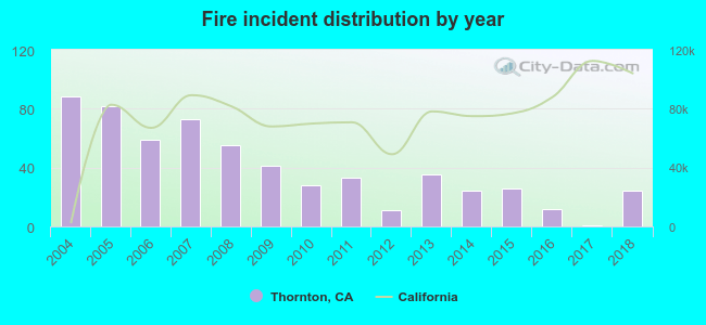 Based on the data from the years 2004 - 2018 the average number of fire incidents per year is 39. The highest number of reported fire incidents - 88 took place in 2004, and the least - 1 in 2017. The data has a declining trend.
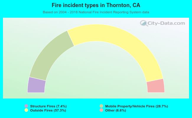 When looking into fire subcategories, the most incidents belonged to: Outside Fires (57.3%), and Mobile Property/Vehicle Fires (28.7%).