Sweetwater, Wyoming
Submit your own pictures of this place and show them to the world
- OSM Map
- General Map
- Google Map
- MSN Map

| Males: 119 | |
| Females: 95 |
| Median resident age: | 45.0 years |
| Wyoming median age: | 36.2 years |
Zip code: 82520
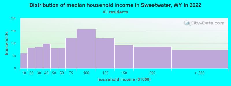
| Sweetwater: | $63,729 |
| WY: | $70,042 |
Estimated per capita income in 2022: $41,462 (it was $23,366 in 2000)
Sweetwater CCD income, earnings, and wages data
Estimated median house or condo value in 2022: $259,631 (it was $86,900 in 2000)
| Sweetwater: | $259,631 |
| WY: | $292,300 |
Compare current foreclosures near your location:
| Photo | Address | Area | Beds / Baths | Price | Details |
|---|---|---|---|---|---|

|
#1
E 21st Ave
Columbus, OH 43211
|
1,061 sq. feet
|
1 baths 3 beds |
$179,900
|
show details |

|
#2
S High St
Columbus, OH 43207
|
1,678 sq. feet
|
2 baths 4 beds |
$31,900
|
show details |

|
#3
Bayberry Cir
Columbus, OH 43207
|
1,564 sq. feet
|
1 baths 3 beds |
$127,500
|
show details |

|
#4
Lehner Rd
Columbus, OH 43224
|
1,628 sq. feet
|
2 baths 4 beds |
show details | |

|
#5
Scottwood Rd
Columbus, OH 43227
|
1,008 sq. feet
|
1 baths 3 beds |
show details | |

|
#6
Grasmere Ave
Columbus, OH 43211
|
720 sq. feet
|
1 baths 2 beds |
show details | |

|
#7
Stoneybrook Blvd # 21a
Hilliard, OH 43026
|
1,231 sq. feet
|
2 baths 3 beds |
show details | |

|
#8
Safford Ave
Columbus, OH 43223
|
784 sq. feet
|
1 baths 2 beds |
show details | |

|
#9
Wrexham Ave
Columbus, OH 43223
|
1,235 sq. feet
|
1 baths 3 beds |
show details | |

|
#10
Meadowbrook Dr
Columbus, OH 43207
|
1,752 sq. feet
|
2 baths 4 beds |
show details |
| Photo | Address | Area | Beds / Baths | Price | Details |
|---|---|---|---|---|---|

|
#11
Hiawatha Park Dr
Columbus, OH 43211
|
1,278 sq. feet
|
1 baths 4 beds |
show details | |

|
#12
Fairfield Ave
Columbus, OH 43203
|
984 sq. feet
|
1 baths 2 beds |
show details | |

|
#13
S Richardson Ave
Columbus, OH 43204
|
1,520 sq. feet
|
2 baths 3 beds |
show details | |

|
#14
Marshrun Dr
Grove City, OH 43123
|
2,036 sq. feet
|
2 baths 4 beds |
show details | |

|
#15
E Howard Rd
Columbus, OH 43207
|
1,056 sq. feet
|
1 baths 3 beds |
show details | |

|
#16
Brookstone Dr
Westerville, OH 43082
|
1,783 sq. feet
|
3 baths 3 beds |
show details | |

|
#17
Midland Ave
Columbus, OH 43223
|
1,518 sq. feet
|
1 baths 2 beds |
show details | |

|
#18
Summertree Ln
Westerville, OH 43081
|
2,496 sq. feet
|
2 baths 3 beds |
show details | |

|
#19
Mink St SW
Pataskala, OH 43062
|
1,442 sq. feet
|
1 baths 3 beds |
show details | |

|
#20
High Free Pike
West Jefferson, OH 43162
|
1,216 sq. feet
|
2 baths 4 beds |
show details |
| Photo | Address | Area | Beds / Baths | Price | Details |
|---|---|---|---|---|---|

|
#21
Fergus Rd
Grove City, OH 43123
|
3,312 sq. feet
|
2 baths 4 beds |
show details | |

|
#22
Armada Rd
Columbus, OH 43232
|
1,028 sq. feet
|
1 baths 4 beds |
show details | |

|
#23
Striebel Ct
Columbus, OH 43227
|
925 sq. feet
|
1 baths 3 beds |
show details | |

|
#24
N 18th St
Columbus, OH 43203
|
1,690 sq. feet
|
1 baths 4 beds |
show details | |

|
#25
Gladys Rd
Columbus, OH 43228
|
832 sq. feet
|
1 baths 3 beds |
show details | |

|
#26
Glenmate Ct
Columbus, OH 43223
|
1,050 sq. feet
|
1 baths 3 beds |
show details | |

|
#27
Sleeping Meadow Dr
New Albany, OH 43054
|
3,211 sq. feet
|
2 baths 4 beds |
show details | |

|
#28
E Welch Ave
Columbus, OH 43207
|
1,864 sq. feet
|
2 baths 4 beds |
show details | |

|
#29
Kingsglen Dr
Grove City, OH 43123
|
1,635 sq. feet
|
2 baths 4 beds |
show details | |

|
#30
Chester Rd
Columbus, OH 43221
|
3,300 sq. feet
|
4 baths 5 beds |
show details |
| Photo | Address | Area | Beds / Baths | Price | Details |
|---|---|---|---|---|---|

|
#31
Bernadette Rd
Columbus, OH 43204
|
1,168 sq. feet
|
1 baths 3 beds |
show details | |

|
#32
S Hague Ave
Columbus, OH 43204
|
979 sq. feet
|
1 baths 2 beds |
show details | |

|
#33
Ashgrove Dr
Grove City, OH 43123
|
1,772 sq. feet
|
2 baths 4 beds |
show details | |

|
#34
Kelton Ave
Columbus, OH 43206
|
1,080 sq. feet
|
1 baths 3 beds |
show details | |

|
#35
London Groveport Rd
Grove City, OH 43123
|
816 sq. feet
|
1 baths 2 beds |
show details | |

|
#36
Chidley St
Galloway, OH 43119
|
1,502 sq. feet
|
1 baths 3 beds |
show details | |

|
#37
Hildreth Ave
Columbus, OH 43203
|
1,798 sq. feet
|
2 baths 4 beds |
show details | |

|
#38
N Roys Ave
Columbus, OH 43204
|
1,248 sq. feet
|
2 baths 3 beds |
show details | |

|
#39
Oreily Dr
Galloway, OH 43119
|
1,533 sq. feet
|
2 baths 3 beds |
show details | |

|
#40
Bostwick Rd
Columbus, OH 43227
|
1,284 sq. feet
|
1 baths 4 beds |
show details |
| Photo | Address | Area | Beds / Baths | Price | Details |
|---|---|---|---|---|---|

|
#41
Berrywood Dr
Columbus, OH 43220
|
1,182 sq. feet
|
1 baths 2 beds |
show details | |

|
#42
Michelle Dr
Grove City, OH 43123
|
1,452 sq. feet
|
2 baths 3 beds |
show details | |

|
#43
Pendent Ln
Columbus, OH 43207
|
1,260 sq. feet
|
2 baths 3 beds |
show details | |

|
#44
Lynn Cir
Grove City, OH 43123
|
936 sq. feet
|
1 baths 3 beds |
show details | |

|
#45
Windy Hill Ln
Galloway, OH 43119
|
1,350 sq. feet
|
2 baths 3 beds |
show details | |

|
#46
Camhurst Ct
Galloway, OH 43119
|
1,969 sq. feet
|
2 baths 3 beds |
show details | |

|
#47
Illinois Ave
Westerville, OH 43081
|
1,120 sq. feet
|
1 baths 3 beds |
show details | |

|
#48
Renford Ct
Powell, OH 43065
|
1,795 sq. feet
|
1 baths 3 beds |
show details | |

|
#49
Royal Farm E
Blacklick, OH 43004
|
2,425 sq. feet
|
2 baths 3 beds |
show details | |

|
Check over 1 million property listings on Foreclosure.com!
|
browse all offers | |||

- 19795.6%White alone
- 62.9%American Indian alone
- 21.0%Hispanic
- 10.5%Two or more races
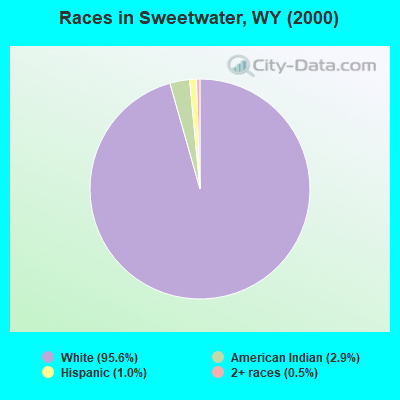
Races in Sweetwater detailed stats: ancestries, foreign born residents, place of birth
 Recent articles from our blog. Our writers, many of them Ph.D. graduates or candidates, create easy-to-read articles on a wide variety of topics.
Current Local Time: MST time zone
Land area: 1960.3 square miles.
Population density: 0.1 people per square mile (very low).
| Sweetwater CCD: | 0.7% ($588) |
| Wyoming: | 0.7% ($627) |
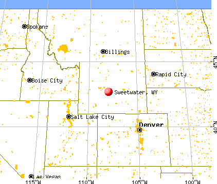
Nearest city with pop. 50,000+: Cheyenne, WY  (193.8 miles , pop. 53,011).
Nearest city with pop. 200,000+: West Adams, CO (247.5 miles , pop. 259,628).
Nearest city with pop. 1,000,000+: Phoenix, AZ (671.0 miles , pop. 1,321,045).
Nearest cities:
), ), Latitude: 42.68 N, Longitude: 107.96 W
Area code commonly used in this area: 307

| Here: | 2.8% |
| Wyoming: | 2.5% |
Average climate in Sweetwater, Wyoming
Based on data reported by over 4,000 weather stations


Earthquake activity:
Sweetwater-area historical earthquake activity is significantly above Wyoming state average. It is 1029% greater than the overall U.S. average.On 8/18/1959 at 06:37:13, a magnitude 7.7 (7.7 UK, Class: Major, Intensity: VIII - XII) earthquake occurred 188.0 miles away from Sweetwater center, causing $26,000,000 total damage
On 10/28/1983 at 14:06:06, a magnitude 7.3 (6.2 MB, 7.3 MS, 7.0 MW) earthquake occurred 309.4 miles away from the city center, causing 2 deaths (2 shaking deaths) and 3 injuries, causing $15,000,000 total damage
On 6/30/1975 at 18:54:13, a magnitude 6.1 (5.6 MB, 5.9 MS, 6.1 UK, 6.1 ML, Class: Strong, Intensity: VII - IX) earthquake occurred 196.0 miles away from Sweetwater center
On 3/28/1975 at 02:31:05, a magnitude 6.2 (6.1 MB, 6.0 MS, 6.2 ML) earthquake occurred 235.5 miles away from Sweetwater center
On 2/3/1994 at 09:05:04, a magnitude 5.8 (5.4 MB, 5.5 MS, 5.8 MW, 5.8 ML, Depth: 4.9 mi, Class: Moderate, Intensity: VI - VII) earthquake occurred 153.0 miles away from the city center
On 10/3/1915 at 06:52:48, a magnitude 7.6 (7.6 UK) earthquake occurred 515.8 miles away from the city center
Magnitude types: body-wave magnitude (MB), local magnitude (ML), surface-wave magnitude (MS), moment magnitude (MW)
Natural disasters:
The number of natural disasters in Fremont County (4) is a lot smaller than the US average (15).Major Disasters (Presidential) Declared: 2
Causes of natural disasters: Floods: 3, Landslide: 1, Storm: 1, Other: 1 (Note: some incidents may be assigned to more than one category).
Colleges/universities with over 2000 students nearest to Sweetwater:
- Casper College (about 84 miles; Casper, WY; Full-time enrollment: 2,770)
- Western Wyoming Community College (about 100 miles; Rock Springs, WY; FT enrollment: 2,086)
- Wyotech-Laramie (about 153 miles; Laramie, WY; FT enrollment: 2,765)
- Sheridan College (about 154 miles; Sheridan, WY; FT enrollment: 2,070)
- University of Wyoming (about 155 miles; Laramie, WY; FT enrollment: 10,810)
- Laramie County Community College (about 197 miles; Cheyenne, WY; FT enrollment: 3,288)
- Colorado State University-Fort Collins (about 208 miles; Fort Collins, CO; FT enrollment: 25,099)
Points of interest:
Notable locations in Sweetwater: Long Creek Ranch (A), Love Ranch (B), Lucky Mac Camp (C), Lucky Mac Uranium Mill (D), McIntosh Ranch (E), McKenzie Windmill (F), Murphy Ranch (G), Myers Ranch (H), Ore Ranch (I), Posey Ranch (J), Puddle Springs Ranch (K), Ramsey Homestead (L), Scarlett Ranch (M), Sherlock Homestead (N), Sherlock Shearing Pens (O), Logan Gulch Oil Well Number 2 (P), Logan Gulch Oil Well Number 1 (Q), Slide Windmill (R), Split Rock Ranch (S), Stratton Ranch (T). Display/hide their locations on the map
Lakes, reservoirs, and swamps: Daley Lake (A), The Dry Lakes (B), Boggy Springs Pond (C), Soda Lakes (D), Carmody Lake (E), Campbell Lake (F), Woods Gulch Pond (G), Auer Reservoir (H). Display/hide their locations on the map
Streams, rivers, and creeks: Magpie Creek (A), Long Creek (B), Antelope Creek (C), Alkali Creek (D), Lankin Creek (E), Jost Creek (F), Indian Grove Creek (G), Ice Slough (H), Horseshoe Creek (I). Display/hide their locations on the map
| This place: | 2.4 people |
| Wyoming: | 2.5 people |
| This place: | 38.8% |
| Whole state: | 67.9% |
| This place: | 5.9% |
| Whole state: | 5.4% |
No gay or lesbian households reported
| This place: | 5.7% |
| Whole state: | 11.4% |
For population 15 years and over in Sweetwater:
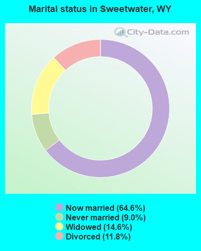
- Never married: 9.0%
- Now married: 64.6%
- Separated: 0.0%
- Widowed: 14.6%
- Divorced: 11.8%
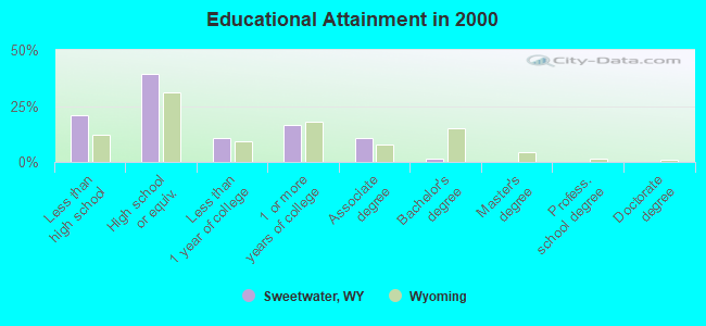
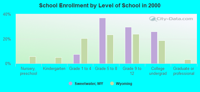
For population 25 years and over in Sweetwater:
- High school or higher: 79.0%
- Bachelor's degree or higher: 1.4%
- Graduate or professional degree: 0.0%
- Mean travel time to work (commute): 16.4 minutes
| Here: | 7.7 |
| Wyoming average: | 10.0 |
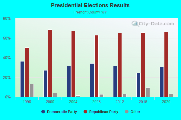
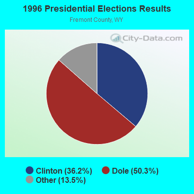
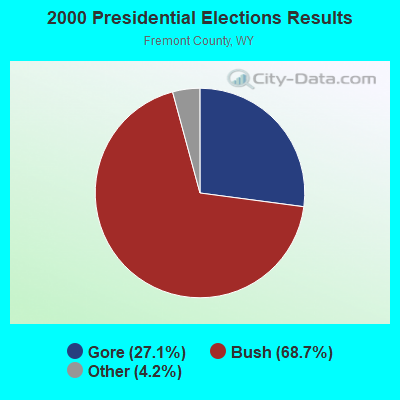


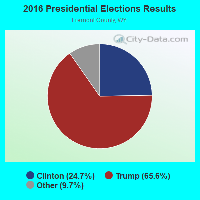

Graphs represent county-level data. Detailed 2008 Election Results
Religion statistics for Sweetwater, WY (based on Fremont County data)
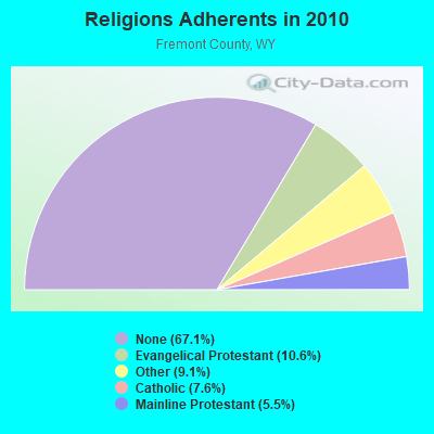
| Religion | Adherents | Congregations |
|---|---|---|
| Evangelical Protestant | 4,269 | 50 |
| Other | 3,658 | 12 |
| Catholic | 3,047 | 10 |
| Mainline Protestant | 2,219 | 16 |
| None | 26,930 | - |
Food Environment Statistics:
| This county: | 2.67 / 10,000 pop. |
| Wyoming: | 2.10 / 10,000 pop. |
| Fremont County: | 0.27 / 10,000 pop. |
| Wyoming: | 0.27 / 10,000 pop. |
| This county: | 1.07 / 10,000 pop. |
| Wyoming: | 0.65 / 10,000 pop. |
| Fremont County: | 3.74 / 10,000 pop. |
| Wyoming: | 5.36 / 10,000 pop. |
| Fremont County: | 9.61 / 10,000 pop. |
| State: | 10.08 / 10,000 pop. |
| Fremont County: | 8.0% |
| Wyoming: | 7.1% |
| Here: | 26.0% |
| State: | 24.4% |
Strongest AM radio stations in Sweetwater:
- KTWO (1030 AM; 50 kW; CASPER, WY; Owner: CITICASTERS LICENSES, L.P.)
- KUYO (830 AM; daytime; 25 kW; EVANSVILLE, WY; Owner: WYOMING CHRISTIAN BROADCASTING COMPANY)
- KOVE (1330 AM; 5 kW; LANDER, WY; Owner: FREMONT BROADCASTING, INC.)
- KALL (700 AM; 50 kW; NORTH SALT LAKE CITY, UT; Owner: CITICASTERS LICENSES, L.P.)
- KLTT (670 AM; 50 kW; COMMERCE CITY, CO; Owner: KLZ RADIO, INC.)
- KKZN (760 AM; 50 kW; THORNTON, CO; Owner: JACOR BROADCASTING OF COLORADO, INC.)
- KIQN (1010 AM; 50 kW; TOOELE, UT)
- KOA (850 AM; 50 kW; DENVER, CO; Owner: JACOR BROADCASTING OF COLORADO, INC.)
- KVOW (1450 AM; 1 kW; RIVERTON, WY; Owner: EDWARDS COMMUNICATIONS, LC)
- KSL (1160 AM; 50 kW; SALT LAKE CITY, UT; Owner: BONNEVILLE HOLDING COMPANY)
- KIMB (1260 AM; 50 kW; KIMBALL, NE; Owner: G & L INVESTMENTS, LLC)
- KNZZ (1100 AM; 50 kW; GRAND JUNCTION, CO; Owner: M B C GRAND BROADCASTING, INC.)
- KMXA (1090 AM; 50 kW; AURORA, CO; Owner: ENTRAVISION HOLDINGS, LLC)
Strongest FM radio stations in Sweetwater:
- KTAK (93.9 FM; RIVERTON, WY; Owner: EDWARDS COMMUNICATIONS, LC)
- KTRZ (93.1 FM; RIVERTON, WY; Owner: JIMMY RAY CARROLL)
- KCWC-FM (88.1 FM; RIVERTON, WY; Owner: CENTRAL WYOMING COLLEGE)
- KWYW (99.1 FM; LOST CABIN, WY; Owner: JIMMY RAY CARROLL)
- K276DV (103.1 FM; EDEN, WY; Owner: WESTERN INSPIRATIONAL BROADCASTERS)
- KDNO (101.7 FM; THERMOPOLIS, WY; Owner: CARJIM, LLC)
- KWRR (89.5 FM; ETHETE, WY; Owner: BUSINESS COUNCIL OF THE NORTHERN ARAPAHO TRIBE)
FCC Registered Microwave Towers:
2- STATION, Exxon Tower 27 Mi Ene Of Kemmerer (Lat: 41.881611 Lon: -110.047917), Overall height: 19.2 m, Call Sign: WNEM321,
Assigned Frequencies: 1935.00 MHz, Grant Date: 10/31/2000, Expiration Date: 01/17/2011, Cancellation Date: 01/27/2003, Phone: (713) 656-1827
- MONUMENT CS, North Of Lincoln Hwy (Lat: 41.760778 Lon: -107.905944), Type: Ltower, Structure height: 21.3 m, Call Sign: WRHX448, Licensee ID: L00007132,
Assigned Frequencies: 10775.0 MHz, 10775.0 MHz, 10775.0 MHz, 10775.0 MHz, Grant Date: 07/07/2020, Expiration Date: 07/07/2030, Certifier: Jerry Henderson, Registrant: Williams Energy Services, One Williams Center, Tulsa, OK 74121, Phone: (918) 573-5731, Fax: (918) 732-7599, Email:
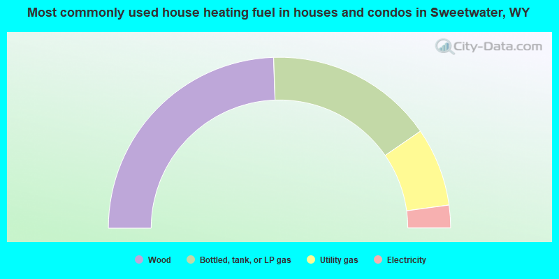
- 48.9%Wood
- 31.9%Bottled, tank, or LP gas
- 14.9%Utility gas
- 4.3%Electricity
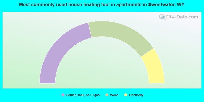
- 42.9%Bottled, tank, or LP gas
- 38.1%Wood
- 19.0%Electricity
Sweetwater compared to Wyoming state average:
- Unemployed percentage significantly below state average.
- Black race population percentage significantly below state average.
- Hispanic race population percentage significantly below state average.
- Foreign-born population percentage significantly below state average.
- Renting percentage significantly below state average.
- Length of stay since moving in significantly above state average.
- Number of rooms per house significantly below state average.
- House age significantly below state average.
- Percentage of population with a bachelor's degree or higher significantly below state average.
Sweetwater on our top lists:
- #52 on the list of "Top 100 cities with largest land areas"
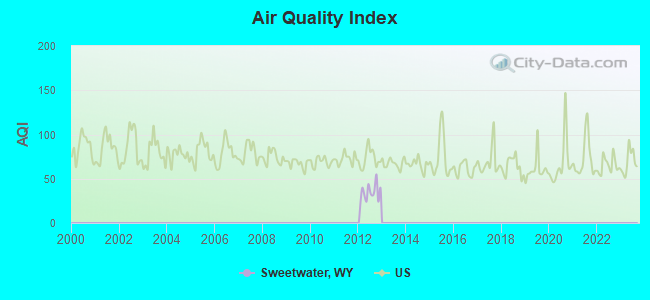
- #9 on the list of "Top 101 counties with the highest Ozone (1-hour) air pollution readings in 2012 (ppm)"
- #13 on the list of "Top 101 counties with the lowest Particulate Matter (PM2.5) Annual air pollution readings in 2012 (µg/m3)"
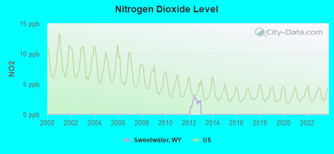
- #16 on the list of "Top 101 counties with the lowest Nitrogen Dioxide air pollution readings in 2012 (ppm)"
- #26 on the list of "Top 101 counties with the lowest Particulate Matter (PM10) Annual air pollution readings in 2012 (µg/m3)"
- #27 on the list of "Top 101 counties with the lowest percentage of residents that visited a dentist within the past year"