Sula-Edwards, Montana
Submit your own pictures of this place and show them to the world
- OSM Map
- Google Map
- MSN Map
| Males: 875 | |
| Females: 682 |
| Median resident age: | 43.7 years |
| Montana median age: | 37.5 years |
Zip code: 59829
| Sula-Edwards: | $67,908 |
| MT: | $67,631 |
Estimated per capita income in 2022: $38,255 (it was $17,567 in 2000)
Sula-Edwards CCD income, earnings, and wages data
Estimated median house or condo value in 2022: $435,690 (it was $129,400 in 2000)
| Sula-Edwards: | $435,690 |
| MT: | $366,400 |
Detailed information about poverty and poor residents in Sula-Edwards, MT
Compare current foreclosures near your location:
| Photo | Address | Area | Beds / Baths | Price | Details |
|---|---|---|---|---|---|

|
#1
Bayberry Cir
Columbus, OH 43207
|
1,564 sq. feet
|
1 baths 3 beds |
$127,500
|
show details |

|
#2
S High St
Columbus, OH 43207
|
1,678 sq. feet
|
2 baths 4 beds |
$31,900
|
show details |

|
#3
E 21st Ave
Columbus, OH 43211
|
1,061 sq. feet
|
1 baths 3 beds |
$179,900
|
show details |

|
#4
Roundelay Rd N
Reynoldsburg, OH 43068
|
1,712 sq. feet
|
2 baths 3 beds |
show details | |

|
#5
E Howard Rd
Columbus, OH 43207
|
1,056 sq. feet
|
1 baths 3 beds |
show details | |

|
#6
London Groveport Rd
Grove City, OH 43123
|
816 sq. feet
|
1 baths 2 beds |
show details | |

|
#7
Chidley St
Galloway, OH 43119
|
1,502 sq. feet
|
1 baths 3 beds |
show details | |

|
#8
Summertree Ln
Westerville, OH 43081
|
2,496 sq. feet
|
2 baths 3 beds |
show details | |

|
#9
E Lincoln Ave
Columbus, OH 43214
|
874 sq. feet
|
1 baths 3 beds |
show details | |

|
#10
Fergus Rd
Grove City, OH 43123
|
3,312 sq. feet
|
2 baths 4 beds |
show details |
| Photo | Address | Area | Beds / Baths | Price | Details |
|---|---|---|---|---|---|

|
#11
Rosewood Ct
Powell, OH 43065
|
2,801 sq. feet
|
3 baths 4 beds |
show details | |

|
#12
Armada Rd
Columbus, OH 43232
|
1,028 sq. feet
|
1 baths 4 beds |
show details | |

|
#13
N Roys Ave
Columbus, OH 43204
|
1,248 sq. feet
|
2 baths 3 beds |
show details | |

|
#14
N Roys Ave
Columbus, OH 43204
|
648 sq. feet
|
2 baths 3 beds |
show details | |

|
#15
S Richardson Ave
Columbus, OH 43204
|
1,520 sq. feet
|
2 baths 3 beds |
show details | |

|
#16
Meadowbrook Dr
Columbus, OH 43207
|
1,752 sq. feet
|
2 baths 4 beds |
show details | |

|
#17
Executive Ct
Westerville, OH 43081
|
1,811 sq. feet
|
2 baths 3 beds |
show details | |

|
#18
High Free Pike
West Jefferson, OH 43162
|
1,216 sq. feet
|
2 baths 4 beds |
show details | |

|
#19
Falls Peak Ln
Delaware, OH 43015
|
1,352 sq. feet
|
2 baths 2 beds |
show details | |

|
#20
Ashgrove Dr
Grove City, OH 43123
|
1,772 sq. feet
|
2 baths 4 beds |
show details |
| Photo | Address | Area | Beds / Baths | Price | Details |
|---|---|---|---|---|---|

|
#21
Lehner Rd
Columbus, OH 43224
|
1,628 sq. feet
|
2 baths 4 beds |
show details | |

|
#22
Grasmere Ave
Columbus, OH 43211
|
720 sq. feet
|
1 baths 2 beds |
show details | |

|
#23
E Welch Ave
Columbus, OH 43207
|
1,864 sq. feet
|
2 baths 4 beds |
show details | |

|
#24
Wrexham Ave
Columbus, OH 43223
|
1,235 sq. feet
|
1 baths 3 beds |
show details | |

|
#25
Kelton Ave
Columbus, OH 43206
|
1,080 sq. feet
|
1 baths 3 beds |
show details | |

|
#26
Hamilton Ave
Columbus, OH 43211
|
1,061 sq. feet
|
1 baths 3 beds |
show details | |

|
#27
Striebel Ct
Columbus, OH 43227
|
925 sq. feet
|
1 baths 3 beds |
show details | |

|
#28
S Champion Ave
Columbus, OH 43207
|
1,157 sq. feet
|
1 baths 2 beds |
show details | |

|
#29
Fairfield Ave
Columbus, OH 43203
|
984 sq. feet
|
1 baths 2 beds |
show details | |

|
#30
N 18th St
Columbus, OH 43203
|
1,690 sq. feet
|
1 baths 4 beds |
show details |
| Photo | Address | Area | Beds / Baths | Price | Details |
|---|---|---|---|---|---|

|
#31
Cannonade Ct
Columbus, OH 43230
|
2,023 sq. feet
|
2 baths 3 beds |
show details | |

|
#32
Glenmate Ct
Columbus, OH 43223
|
1,050 sq. feet
|
1 baths 3 beds |
show details | |

|
#33
Safford Ave
Columbus, OH 43223
|
784 sq. feet
|
1 baths 2 beds |
show details | |

|
#34
Chester Rd
Columbus, OH 43221
|
3,300 sq. feet
|
4 baths 5 beds |
show details | |

|
#35
Upton Rd E
Columbus, OH 43232
|
852 sq. feet
|
1 baths 3 beds |
show details | |

|
#36
Whittman Ct
Plain City, OH 43064
|
3,186 sq. feet
|
3 baths 4 beds |
show details | |

|
#37
Hildreth Ave
Columbus, OH 43203
|
1,798 sq. feet
|
2 baths 4 beds |
show details | |

|
#38
Gladys Rd
Columbus, OH 43228
|
832 sq. feet
|
1 baths 3 beds |
show details | |

|
#39
Mccutcheon Rd
Columbus, OH 43219
|
2,130 sq. feet
|
2 baths 3 beds |
show details | |

|
#40
Hedgerow Rd
Columbus, OH 43220
|
1,102 sq. feet
|
2 baths 2 beds |
show details |
| Photo | Address | Area | Beds / Baths | Price | Details |
|---|---|---|---|---|---|

|
#41
Stephen St
Grove City, OH 43123
|
1,027 sq. feet
|
1 baths 3 beds |
show details | |

|
#42
Messner Dr
Hilliard, OH 43026
|
832 sq. feet
|
1 baths 2 beds |
show details | |

|
#43
Falene Pl
Galloway, OH 43119
|
1,178 sq. feet
|
1 baths 3 beds |
show details | |

|
#44
Autumn Wind Dr
Grove City, OH 43123
|
1,697 sq. feet
|
2 baths 3 beds |
show details | |

|
#45
Wesson Dr
Columbus, OH 43232
|
1,200 sq. feet
|
1 baths 3 beds |
show details | |

|
#46
Stoneybrook B 21a
Hilliard, OH 43026
|
1,031 sq. feet
|
1 baths 3 beds |
show details | |

|
#47
Almont Dr
Columbus, OH 43229
|
1,563 sq. feet
|
2 baths 5 beds |
show details | |

|
#48
Windy Hill Ln
Galloway, OH 43119
|
1,350 sq. feet
|
2 baths 3 beds |
show details | |

|
#49
Conway Dr
Columbus, OH 43227
|
1,225 sq. feet
|
1 baths 3 beds |
show details | |

|
Check over 1 million property listings on Foreclosure.com!
|
browse all offers | |||

- 1,31093.4%White alone
- 433.1%Hispanic
- 332.4%American Indian alone
- 90.6%Two or more races
- 50.4%Asian alone
- 30.2%Black alone
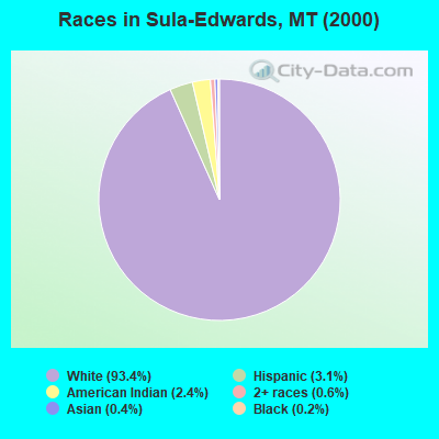
Races in Sula-Edwards detailed stats: ancestries, foreign born residents, place of birth
 Recent articles from our blog. Our writers, many of them Ph.D. graduates or candidates, create easy-to-read articles on a wide variety of topics.
Current Local Time: MST time zone
Land area: 989.1 square miles.
Population density: 1.6 people per square mile (very low).
| Sula-Edwards CCD: | 0.5% ($643) |
| Montana: | 1.3% ($1,212) |
Nearest city with pop. 50,000+: Missoula, MT  (73.8 miles , pop. 57,053).
Nearest city with pop. 200,000+: East Seattle, WA (400.9 miles , pop. 480,100).
Nearest city with pop. 1,000,000+: Los Angeles, CA (840.4 miles , pop. 3,694,820).
Nearest cities:
), )Latitude: 45.80 N, Longitude: 114.14 W
Area code commonly used in this area: 406

| Here: | 3.9% |
| Montana: | 3.8% |
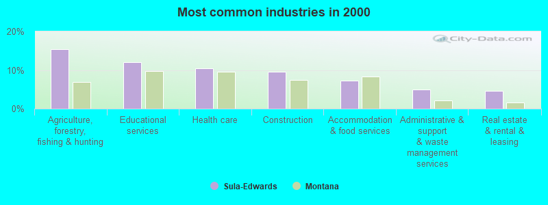
- Agriculture, forestry, fishing & hunting (15.4%)
- Educational services (12.1%)
- Health care (10.4%)
- Construction (9.5%)
- Accommodation & food services (7.3%)
- Administrative & support & waste management services (5.0%)
- Real estate & rental & leasing (4.7%)
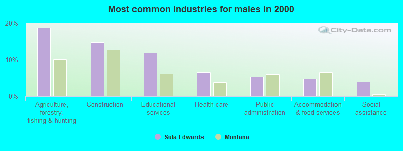
- Agriculture, forestry, fishing & hunting (18.8%)
- Construction (14.8%)
- Educational services (11.8%)
- Health care (6.5%)
- Public administration (5.4%)
- Accommodation & food services (4.8%)
- Social assistance (4.0%)
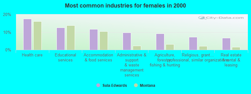
- Health care (17.5%)
- Educational services (12.6%)
- Accommodation & food services (11.7%)
- Administrative & support & waste management services (9.7%)
- Agriculture, forestry, fishing & hunting (9.2%)
- Religious, grantmaking, civic, professional, similar organizations (7.3%)
- Real estate & rental & leasing (6.8%)

- Building and grounds cleaning and maintenance occupations (12.5%)
- Other management occupations, except farmers and farm managers (7.3%)
- Farmers and farm managers (5.5%)
- Other sales and related occupations, including supervisors (4.5%)
- Other office and administrative support workers, including supervisors (3.8%)
- Other construction workers and helpers (3.1%)
- Information and record clerks, except customer service representatives (2.9%)

- Building and grounds cleaning and maintenance occupations (12.1%)
- Farmers and farm managers (7.3%)
- Other management occupations, except farmers and farm managers (4.8%)
- Other construction workers and helpers (4.8%)
- Health technologists and technicians (4.0%)
- Cooks and food preparation workers (3.8%)
- Agricultural workers, including supervisors (3.8%)

- Building and grounds cleaning and maintenance occupations (13.1%)
- Other management occupations, except farmers and farm managers (11.7%)
- Other office and administrative support workers, including supervisors (10.7%)
- Other sales and related occupations, including supervisors (9.2%)
- Information and record clerks, except customer service representatives (6.8%)
- Other teachers, instructors, education, training, and library occupations (6.3%)
- Bookkeeping, accounting, and auditing clerks (6.3%)
Average climate in Sula-Edwards, Montana
Based on data reported by over 4,000 weather stations


Earthquake activity:
Sula-Edwards-area historical earthquake activity is significantly above Montana state average. It is 1063% greater than the overall U.S. average.On 8/18/1959 at 06:37:13, a magnitude 7.7 (7.7 UK, Class: Major, Intensity: VIII - XII) earthquake occurred 189.9 miles away from the city center, causing $26,000,000 total damage
On 10/28/1983 at 14:06:06, a magnitude 7.3 (6.2 MB, 7.3 MS, 7.0 MW) earthquake occurred 120.2 miles away from the city center, causing 2 deaths (2 shaking deaths) and 3 injuries, causing $15,000,000 total damage
On 3/31/2020 at 23:52:30, a magnitude 6.5 (6.5 MW, Depth: 7.5 mi, Class: Strong, Intensity: VII - IX) earthquake occurred 104.0 miles away from the city center
On 10/3/1915 at 06:52:48, a magnitude 7.6 (7.6 UK) earthquake occurred 403.8 miles away from the city center
On 8/22/1984 at 09:46:30, a magnitude 5.8 (5.0 MB, 5.1 MS, 5.8 ML, Class: Moderate, Intensity: VI - VII) earthquake occurred 91.1 miles away from the city center
On 10/29/1983 at 23:29:11, a magnitude 5.8 (5.4 MB, 5.0 MS, 5.8 ML) earthquake occurred 102.5 miles away from Sula-Edwards center
Magnitude types: body-wave magnitude (MB), local magnitude (ML), surface-wave magnitude (MS), moment magnitude (MW)
Natural disasters:
The number of natural disasters in Ravalli County (8) is smaller than the US average (15).Major Disasters (Presidential) Declared: 5
Emergencies Declared: 1
Causes of natural disasters: Floods: 4, Storms: 3, Fires: 2, Hurricane: 1, Snow: 1, Other: 1 (Note: some incidents may be assigned to more than one category).
Colleges/universities with over 2000 students nearest to Sula-Edwards:
- The University of Montana (about 74 miles; Missoula, MT; Full-time enrollment: 13,602)
- Lewis-Clark State College (about 145 miles; Lewiston, ID; FT enrollment: 3,199)
- Montana State University (about 150 miles; Bozeman, MT; FT enrollment: 12,942)
- University of Idaho (about 153 miles; Moscow, ID; FT enrollment: 10,416)
- Washington State University (about 159 miles; Pullman, WA; FT enrollment: 25,055)
- Brigham Young University-Idaho (about 180 miles; Rexburg, ID; FT enrollment: 30,522)
- North Idaho College (about 182 miles; Coeur d'Alene, ID; FT enrollment: 4,684)
Points of interest:
Notable locations in Sula-Edwards: Little Boulder Bay Boat Launch (A), Painted Rocks State Recreation Campground (B), Slate Creek Campground (C), Boulder Creek Campground (D), Sula Clubhouse (E), Low Saddle (F), Lost Trail Hot Springs Resort (G), Martin Creek Campground (H), Nez Perce Camp (I), Rombo Creek Campground (J), Spring Gulch Campground (K), Sula Ranger Station (L), Alta Recreation Site (M), Cooper Place (N), Porcupine Saddle Trailhead (O), Lost Trail Sprots Area (P), Saddle Mountain Fire Area Poin of Interest (Q), East Fork Forest Service Station (R), Crazy Creek Campground (S), Trapper Creek Rural Conservation Center (T). Display/hide their locations on the map
Churches in Sula-Edwards include: Corner Wesleyan Church (A), Conner Church (B). Display/hide their locations on the map
Cemeteries: Sula Cemetery (1), Rombo Cemetery (2). Display/hide their locations on the map
Lakes and reservoirs: Hidden Lake (A), Ripple Lake (B), Carmine Lake (C), Capri Lake (D), Hope Lake (E), Chaffin Lake (F), Burrell Lake (G), Alpine Lakes (H). Display/hide their locations on the map
Streams, rivers, and creeks: Praine Creek (A), Alpine Creek (B), Andrews Creek (C), Angle Creek (D), Applebury Creek (E), Baker Creek (F), Balsam Creek (G), Base Creek (H), Basin Creek (I). Display/hide their locations on the map
Parks in Sula-Edwards include: Painted Rocks State Recreation Area (1), Billie Springer Memorial Park (2), Medicine Tree Historical Marker (3), Ross Hole Historical Marker (4). Display/hide their locations on the map
| This place: | 2.2 people |
| Montana: | 2.5 people |
| This place: | 59.5% |
| Whole state: | 66.6% |
| This place: | 5.2% |
| Whole state: | 5.0% |
No gay or lesbian households reported
| This place: | 32.0% |
| Whole state: | 14.6% |
| This place: | 17.5% |
| Whole state: | 5.8% |
6 people in nursing homes in 2000
For population 15 years and over in Sula-Edwards:

- Never married: 29.0%
- Now married: 56.7%
- Separated: 1.0%
- Widowed: 3.9%
- Divorced: 10.4%
For population 25 years and over in Sula-Edwards:
- High school or higher: 87.1%
- Bachelor's degree or higher: 23.4%
- Graduate or professional degree: 4.2%
- Unemployed: 5.4%
- Mean travel time to work (commute): 20.9 minutes


| Here: | 8.5 |
| Montana average: | 10.4 |
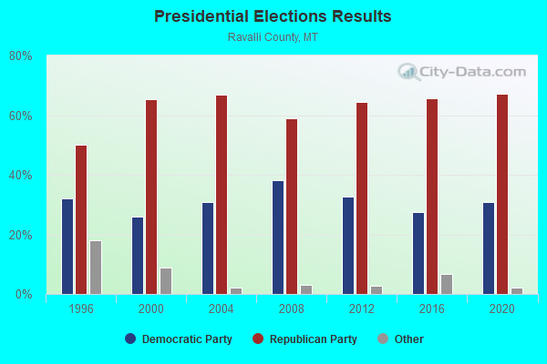
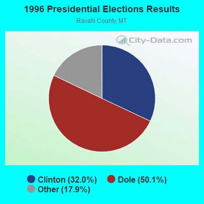
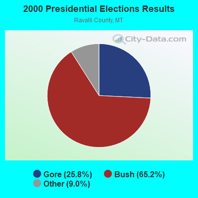

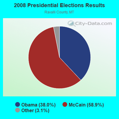
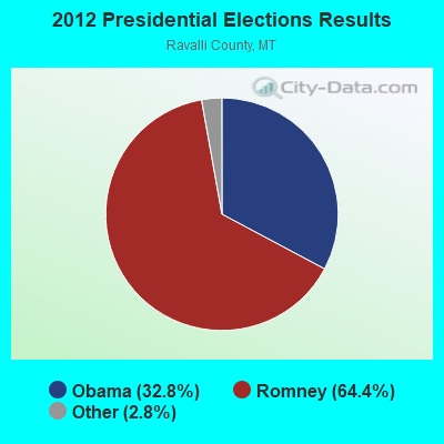
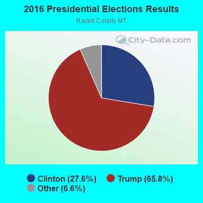
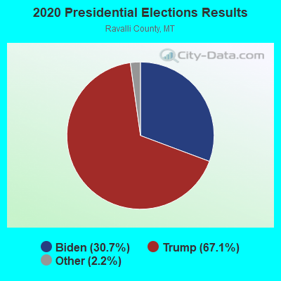
Graphs represent county-level data. Detailed 2008 Election Results
Religion statistics for Sula-Edwards, MT (based on Ravalli County data)
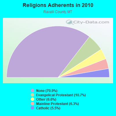
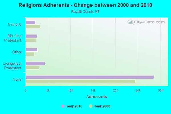
| Religion | Adherents | Congregations |
|---|---|---|
| Evangelical Protestant | 4,318 | 37 |
| Other | 2,644 | 11 |
| Mainline Protestant | 2,522 | 11 |
| Catholic | 2,225 | 4 |
| None | 28,503 | - |
Food Environment Statistics:
| Ravalli County: | 2.73 / 10,000 pop. |
| Montana: | 2.55 / 10,000 pop. |
| Ravalli County: | 0.50 / 10,000 pop. |
| Montana: | 0.48 / 10,000 pop. |
| This county: | 3.72 / 10,000 pop. |
| Montana: | 4.69 / 10,000 pop. |
| Ravalli County: | 10.91 / 10,000 pop. |
| Montana: | 10.38 / 10,000 pop. |
| This county: | 6.3% |
| Montana: | 7.2% |
| Ravalli County: | 18.5% |
| Montana: | 23.1% |
| This county: | 11.0% |
| State: | 10.7% |
Strongest AM radio stations in Sula-Edwards:
- KERR (750 AM; 50 kW; POLSON, MT; Owner: ANDERSON RADIO BROADCASTING, INC.)
- KBOI (670 AM; 50 kW; BOISE, ID; Owner: CITADEL BROADCASTING COMPANY)
- KOFI (1180 AM; 50 kW; KALISPELL, MT; Owner: KOFI, INC.)
- KBOW (550 AM; 5 kW; BUTTE, MT; Owner: BUTTE BROADCASTING INCORPORATED)
- KWEI (1260 AM; 50 kW; WEISER, ID; Owner: TREASURE VALLEY BROADCASTING CO.)
- KLCY (930 AM; 5 kW; EAST MISSOULA, MT; Owner: CAPSTAR TX LIMITED PARTNERSHIP)
- KGA (1510 AM; 50 kW; SPOKANE, WA; Owner: CITADEL BROADCASTING COMPANY)
- KQQQ (1150 AM; 25 kW; PULLMAN, WA; Owner: RADIO PALOUSE, INC.)
- KLYQ (1240 AM; 1 kW; HAMILTON, MT; Owner: CAPSTAR TX LIMITED PARTNERSHIP)
- KTBI (810 AM; daytime; 50 kW; EPHRATA, WA; Owner: TACOMA BROADCASTERS, INCORPORATED)
- KGVO (1290 AM; 5 kW; MISSOULA, MT; Owner: CAPSTAR TX LIMITED PARTNERSHIP)
- KGVW (640 AM; 10 kW; BELGRADE, MT; Owner: GALLATIN VALLEY WITNESS, INC.)
- KXTL (1370 AM; 5 kW; BUTTE, MT; Owner: FISHER RADIO REGIONAL GROUP, INC.)
Strongest FM radio stations in Sula-Edwards:
- KBAZ (96.3 FM; HAMILTON, MT; Owner: CAPSTAR TX LIMITED PARTNERSHIP)
- KUFN (91.9 FM; HAMILTON, MT; Owner: THE UNIVERSITY OF MONTANA)

- 37.8%Wood
- 36.9%Bottled, tank, or LP gas
- 13.7%Electricity
- 6.1%Fuel oil, kerosene, etc.
- 4.3%Other fuel
- 1.1%Utility gas

- 54.8%Bottled, tank, or LP gas
- 27.4%Wood
- 17.8%Electricity
Sula-Edwards compared to Montana state average:
- Unemployed percentage below state average.
- Median age above state average.
- Foreign-born population percentage significantly below state average.
- Renting percentage significantly below state average.
- Length of stay since moving in significantly above state average.
- Number of rooms per house significantly below state average.
- House age significantly below state average.
- Institutionalized population percentage significantly above state average.
- Number of college students below state average.
Sula-Edwards on our top lists:
- #4 on the list of "Top 101 cities with the largest percentage of people in job corps and vocational training facilities (population 1,000+)"
- #3 on the list of "Top 101 counties with the highest Particulate Matter (PM2.5) Annual air pollution readings in 2012 (µg/m3)"