Stonington, Maine

Stonington: Stonington Harbor at dusk

Stonington: Sylvesters Cove - mid afternoon

Stonington: Stonington in the spring

Stonington: Public pier
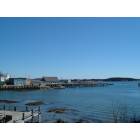
Stonington: Coastline view

Stonington: Stonington Harbor

Stonington: history

Stonington: January 22, 2006 Late afternoon sun-winter lobster boats

Stonington: Boat, Fog, Stonington Harbor

Stonington: Stonington Thorofare

Stonington: Stonington,Maine(from the town pier)
- add
your
Submit your own pictures of this town and show them to the world
- OSM Map
- General Map
- Google Map
- MSN Map
Population change since 2000: -9.5%
 |
| Males: 518 | |
| Females: 525 |
| Median resident age: | 50.7 years |
| Maine median age: | 43.0 years |
Zip codes: 04681.
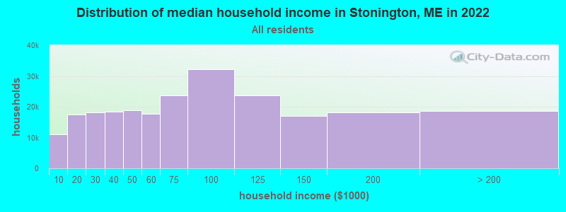
| Stonington: | $52,738 |
| ME: | $69,543 |
Estimated per capita income in 2022: $31,743 (it was $15,634 in 2000)
Stonington town income, earnings, and wages data
Estimated median house or condo value in 2022: $266,052 (it was $92,900 in 2000)
| Stonington: | $266,052 |
| ME: | $290,600 |
Mean prices in 2022: all housing units: $379,336; detached houses: $396,802; townhouses or other attached units: $600,716; in 2-unit structures: $274,479; in 3-to-4-unit structures: $212,346; in 5-or-more-unit structures: $146,369; mobile homes: $158,183; occupied boats, rvs, vans, etc.: $16,454
Detailed information about poverty and poor residents in Stonington, ME


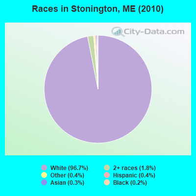
- 1,00996.7%White alone
- 191.8%Two or more races
- 40.4%Other race alone
- 40.4%Hispanic
- 30.3%Asian alone
- 20.2%Black alone
- 10.10%American Indian alone
- 10.10%Native Hawaiian and Other
Pacific Islander alone
Races in Stonington detailed stats: ancestries, foreign born residents, place of birth
According to our research of Maine and other state lists, there was 1 registered sex offender living in Stonington, Maine as of July 03, 2024.
The ratio of all residents to sex offenders in Stonington is 1,043 to 1.
The ratio of registered sex offenders to all residents in this city is lower than the state average.
 Recent articles from our blog. Our writers, many of them Ph.D. graduates or candidates, create easy-to-read articles on a wide variety of topics.

 | What's fun to do in Blue Hill and Ellsworth? (12 replies) |
| Maine Lobster seafood delivery - is it worth it? (19 replies) |
| Seasonal Maine gift box (11 replies) |
| Does Sebec exist? (20 replies) |
| Maine weather thread (3207 replies) |
| How to get to Stonington - Deer Isle from Portland or Bangor....? (6 replies) |
Latest news from Stonington, ME collected exclusively by city-data.com from local newspapers, TV, and radio stations
Stonington, ME City Guides:
Ancestries: English (31.9%), United States (14.1%), Irish (12.2%), French (11.2%), Scottish (6.8%), German (5.8%).
Current Local Time: EST time zone
Incorporated on 02/18/1897
Elevation: 75 feet
Land area: 9.80 square miles.
Population density: 106 people per square mile (very low).
23 residents are foreign born
| This town: | 2.0% |
| Maine: | 2.9% |
| Stonington town: | 1.1% ($1,066) |
| Maine: | 1.5% ($1,417) |
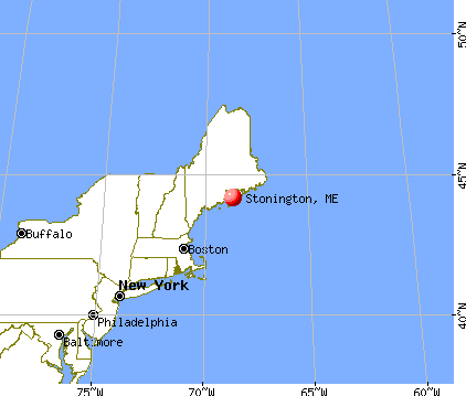
Nearest city with pop. 50,000+: Portland, ME  (87.2 miles , pop. 64,249).
Nearest city with pop. 200,000+: Boston, MA (176.7 miles , pop. 589,141).
Nearest city with pop. 1,000,000+: Bronx, NY (351.1 miles , pop. 1,332,650).
Nearest cities:
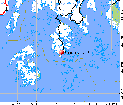
), ), Latitude: 44.17 N, Longitude: 68.66 W
Area code commonly used in this area: 207

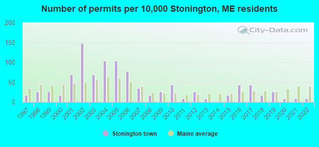
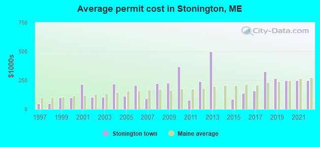
Single-family new house construction building permits:
- 2022: 1 building, cost: $250,000
- 2021: 1 building, cost: $250,000
- 2020: 1 building, cost: $250,000
- 2019: 3 buildings, average cost: $266,700
- 2018: 2 buildings, average cost: $325,000
- 2017: 5 buildings, average cost: $162,000
- 2016: 5 buildings, average cost: $141,200
- 2015: 2 buildings, average cost: $87,500
- 2013: 1 building, cost: $500,000
- 2012: 3 buildings, average cost: $243,300
- 2011: 1 building, cost: $80,000
- 2010: 5 buildings, average cost: $370,000
- 2009: 3 buildings, average cost: $226,700
- 2008: 2 buildings, average cost: $225,000
- 2007: 4 buildings, average cost: $95,000
- 2006: 9 buildings, average cost: $205,600
- 2005: 12 buildings, average cost: $113,800
- 2004: 12 buildings, average cost: $220,600
- 2003: 8 buildings, average cost: $106,900
- 2002: 17 buildings, average cost: $104,700
- 2001: 8 buildings, average cost: $216,000
- 2000: 2 buildings, average cost: $100,000
- 1999: 3 buildings, average cost: $100,000
- 1998: 3 buildings, average cost: $50,000
- 1997: 2 buildings, average cost: $50,000
| Here: | 5.1% |
| Maine: | 3.4% |
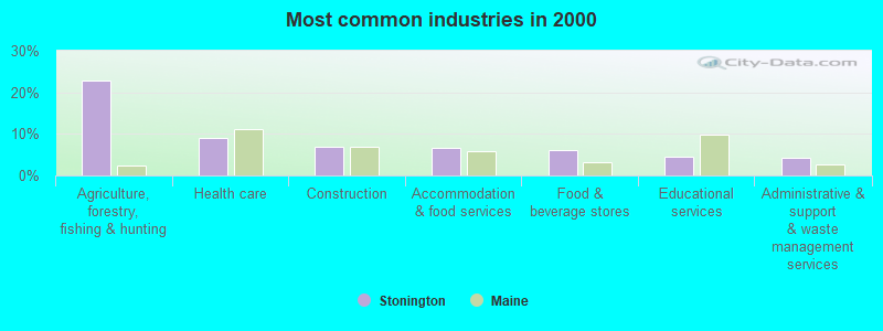
- Agriculture, forestry, fishing & hunting (22.9%)
- Health care (9.0%)
- Construction (6.8%)
- Accommodation & food services (6.6%)
- Food & beverage stores (6.2%)
- Educational services (4.4%)
- Administrative & support & waste management services (4.2%)
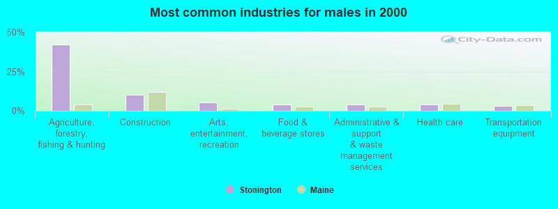
- Agriculture, forestry, fishing & hunting (42.0%)
- Construction (10.1%)
- Arts, entertainment, recreation (5.5%)
- Food & beverage stores (4.2%)
- Administrative & support & waste management services (3.8%)
- Health care (3.8%)
- Transportation equipment (2.9%)
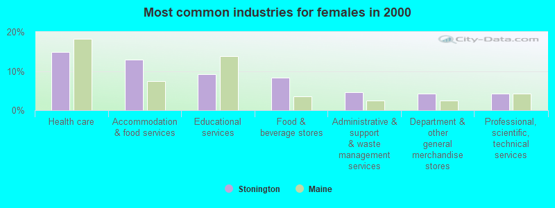
- Health care (14.8%)
- Accommodation & food services (13.0%)
- Educational services (9.3%)
- Food & beverage stores (8.3%)
- Administrative & support & waste management services (4.6%)
- Department & other general merchandise stores (4.2%)
- Professional, scientific, technical services (4.2%)
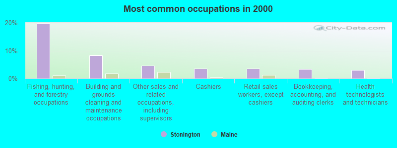
- Fishing, hunting, and forestry occupations (19.8%)
- Building and grounds cleaning and maintenance occupations (8.4%)
- Other sales and related occupations, including supervisors (4.6%)
- Cashiers (3.5%)
- Retail sales workers, except cashiers (3.5%)
- Bookkeeping, accounting, and auditing clerks (3.3%)
- Health technologists and technicians (3.1%)
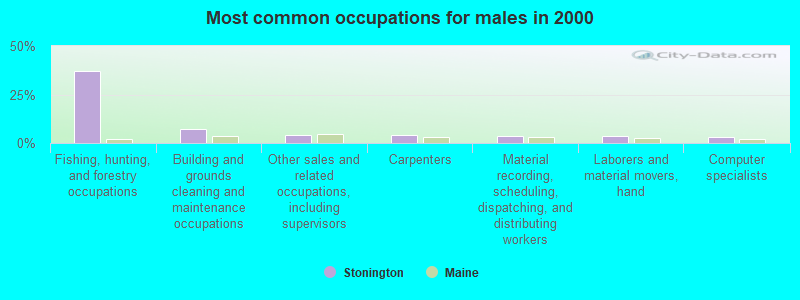
- Fishing, hunting, and forestry occupations (37.0%)
- Building and grounds cleaning and maintenance occupations (7.1%)
- Other sales and related occupations, including supervisors (4.2%)
- Carpenters (4.2%)
- Material recording, scheduling, dispatching, and distributing workers (3.8%)
- Laborers and material movers, hand (3.4%)
- Computer specialists (2.9%)
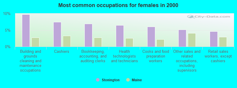
- Building and grounds cleaning and maintenance occupations (9.7%)
- Cashiers (7.4%)
- Bookkeeping, accounting, and auditing clerks (6.9%)
- Health technologists and technicians (6.5%)
- Cooks and food preparation workers (6.0%)
- Other sales and related occupations, including supervisors (5.1%)
- Retail sales workers, except cashiers (4.6%)
Average climate in Stonington, Maine
Based on data reported by over 4,000 weather stations


(lower is better)
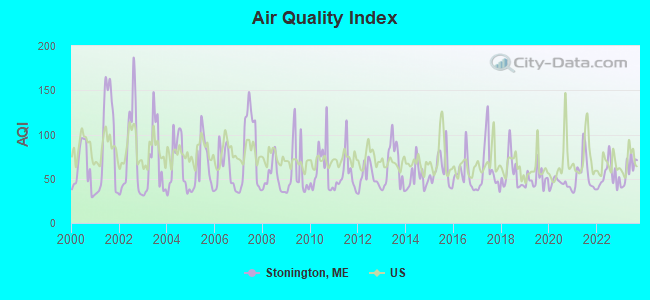
Air Quality Index (AQI) level in 2023 was 59.7. This is better than average.
| City: | 59.7 |
| U.S.: | 72.6 |
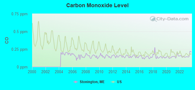
Carbon Monoxide (CO) [ppm] level in 2023 was 0.172. This is significantly better than average. Closest monitor was 24.6 miles away from the city center.
| City: | 0.172 |
| U.S.: | 0.251 |
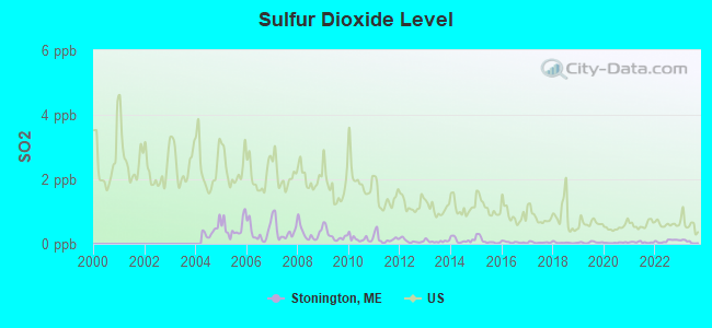
Sulfur Dioxide (SO2) [ppb] level in 2023 was 0.0636. This is significantly better than average. Closest monitor was 18.4 miles away from the city center.
| City: | 0.0636 |
| U.S.: | 1.5147 |
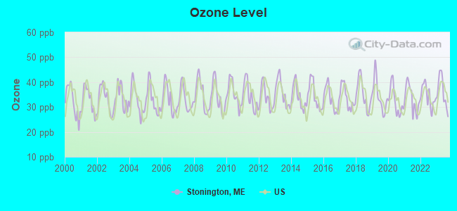
Ozone [ppb] level in 2023 was 36.2. This is about average. Closest monitor was 4.7 miles away from the city center.
| City: | 36.2 |
| U.S.: | 33.3 |
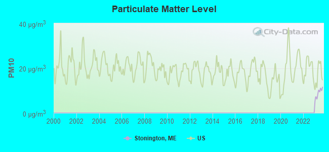
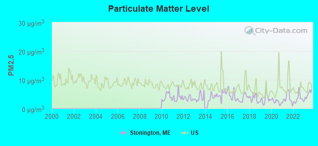
Particulate Matter (PM2.5) [µg/m3] level in 2023 was 4.90. This is significantly better than average. Closest monitor was 24.5 miles away from the city center.
| City: | 4.90 |
| U.S.: | 8.11 |
Earthquake activity:
Stonington-area historical earthquake activity is significantly above Maine state average. It is 79% smaller than the overall U.S. average.On 10/16/2012 at 23:12:25, a magnitude 4.7 (4.7 ML, Depth: 10.0 mi, Class: Light, Intensity: IV - V) earthquake occurred 106.9 miles away from Stonington center
On 4/20/2002 at 10:50:47, a magnitude 5.3 (5.3 ML, Depth: 3.0 mi, Class: Moderate, Intensity: VI - VII) earthquake occurred 250.1 miles away from Stonington center
On 4/20/2002 at 10:50:47, a magnitude 5.2 (5.2 MB, 4.2 MS, 5.2 MW, 5.0 MW) earthquake occurred 251.0 miles away from the city center
On 1/19/1982 at 00:14:42, a magnitude 4.7 (4.5 MB, 4.7 MD, 4.5 LG) earthquake occurred 153.6 miles away from the city center
On 10/7/1983 at 10:18:46, a magnitude 5.3 (5.1 MB, 5.3 LG, 5.1 ML) earthquake occurred 282.6 miles away from the city center
On 2/26/1999 at 03:38:43, a magnitude 3.8 (3.8 LG, Depth: 2.0 mi, Class: Light, Intensity: II - III) earthquake occurred 47.5 miles away from the city center
Magnitude types: regional Lg-wave magnitude (LG), body-wave magnitude (MB), duration magnitude (MD), local magnitude (ML), surface-wave magnitude (MS), moment magnitude (MW)
Natural disasters:
The number of natural disasters in Hancock County (18) is near the US average (15).Major Disasters (Presidential) Declared: 11
Emergencies Declared: 6
Causes of natural disasters: Floods: 9, Storms: 8, Snows: 5, Blizzard: 1, Heavy Rain: 1, Hurricane: 1, Ice Storm: 1, Landslide: 1, Snowfall: 1, Wind: 1, Winter Storm: 1, Other: 2 (Note: some incidents may be assigned to more than one category).

Airports located in Stonington:
- Stonington Municipal Airport (93B) (Runways: 1, Itinerant Ops: 400, Local Ops: 700)
Colleges/universities with over 2000 students nearest to Stonington:
- Husson University (about 47 miles; Bangor, ME; Full-time enrollment: 2,421)
- University of Maine (about 51 miles; Orono, ME; FT enrollment: 8,931)
- University of Maine at Augusta (about 58 miles; Augusta, ME; FT enrollment: 3,204)
- University of Maine at Farmington (about 82 miles; Farmington, ME; FT enrollment: 2,036)
- Southern Maine Community College (about 86 miles; South Portland, ME; FT enrollment: 4,666)
- University of Southern Maine (about 88 miles; Portland, ME; FT enrollment: 6,647)
- Saint Joseph's College of Maine (about 94 miles; Standish, ME; FT enrollment: 2,010)
Points of interest:
Notable location: Stonington Volunteer Fire Department (A). Display/hide its location on the map
Churches in Stonington include: Galilean Gospel Temple (A), Stonington Methodist Church (B). Display/hide their locations on the map
Cemeteries: Greenwood Cemetery (1), Forest Cemetery (2). Display/hide their locations on the map
Lakes: Ames Pond (A), Burntland Pond (B), Georges Pond (C). Display/hide their locations on the map
Park in Stonington: Crockett Cove Woods Preserve (1). Display/hide its location on the map
Drinking water stations with addresses in Stonington and their reported violations in the past:
STONINGTON WATER COMPANY (Population served: 733, Groundwater):Past health violations:ISLAND MEDICAL CENTER INCORPORATED (Population served: 150, Groundwater):Past monitoring violations:
- MCL, Average - Between OCT-2012 and DEC-2012, Contaminant: TTHM. Follow-up actions: St Public Notif requested (DEC-21-2012), St Formal NOV issued (DEC-21-2012), St Public Notif received (JAN-22-2013), St Compliance achieved (JUN-04-2013)
- MCL, Average - Between JUL-2012 and SEP-2012, Contaminant: TTHM. Follow-up actions: St Public Notif requested (SEP-13-2012), St Formal NOV issued (SEP-13-2012), St Public Notif received (OCT-16-2012), St Compliance achieved (JUN-04-2013)
- MCL, Average - Between OCT-2008 and DEC-2008, Contaminant: Combined Uranium. Follow-up actions: St Formal NOV issued (FEB-12-2009), St Compliance achieved (2 times from DEC-04-2009 to JAN-07-2010)
- MCL, Average - Between JUL-2008 and SEP-2008, Contaminant: Combined Uranium. Follow-up actions: St Public Notif requested (AUG-06-2008), St Formal NOV issued (AUG-06-2008), St Public Notif received (SEP-03-2008), St Compliance achieved (2 times from DEC-04-2009 to JAN-07-2010)
- MCL, Average - Between APR-2008 and JUN-2008, Contaminant: Combined Uranium. Follow-up actions: St Public Notif requested (AUG-06-2008), St Formal NOV issued (AUG-06-2008), St Public Notif received (SEP-03-2008), St Compliance achieved (2 times from DEC-04-2009 to JAN-07-2010)
- MCL, Average - Between JAN-2008 and MAR-2008, Contaminant: Combined Uranium. Follow-up actions: St Public Notif requested (JAN-30-2008), St Formal NOV issued (JAN-30-2008), St Public Notif received (MAR-04-2008), St Compliance achieved (2 times from DEC-04-2009 to JAN-07-2010)
- MCL, Average - Between OCT-2007 and DEC-2007, Contaminant: Combined Uranium. Follow-up actions: St Public Notif requested (JAN-30-2008), St Formal NOV issued (JAN-30-2008), St Public Notif received (MAR-04-2008), St Compliance achieved (2 times from DEC-04-2009 to JAN-07-2010)
- 6 regular monitoring violations
Past health violations:GREENLAW MOBILE/RV PARK (Population served: 88, Groundwater):Past monitoring violations:
- MCL, Monthly (TCR) - In NOV-2005, Contaminant: Coliform. Follow-up actions: St Public Notif requested (DEC-08-2005), St Violation/Reminder Notice (DEC-08-2005), St Compliance achieved (MAR-12-2007), St Intentional no-action (AUG-24-2011)
- MCL, Monthly (TCR) - In OCT-2005, Contaminant: Coliform. Follow-up actions: St Public Notif requested (OCT-28-2005), St Violation/Reminder Notice (OCT-28-2005), St Public Notif received (2 times from NOV-16-2005 to NOV-16-2005), St Compliance achieved (MAR-12-2007)
- MCL, Monthly (TCR) - In SEP-2005, Contaminant: Coliform. Follow-up actions: St Public Notif requested (OCT-26-2005), St Violation/Reminder Notice (OCT-26-2005), St Compliance achieved (MAR-12-2007), St Intentional no-action (AUG-24-2011)
- MCL, Monthly (TCR) - In JUL-2005, Contaminant: Coliform. Follow-up actions: St Public Notif requested (JUL-11-2005), St Violation/Reminder Notice (JUL-11-2005), St Public Notif received (2 times from JUL-22-2005 to JUL-22-2005), St Compliance achieved (MAR-12-2007)
- 6 routine major monitoring violations
Past health violations:COCKATOO PORTUGUESE RESTAURANT (Population served: 82, Groundwater):Past monitoring violations:
- MCL, Monthly (TCR) - In JUL-2011, Contaminant: Coliform. Follow-up actions: St Compliance achieved (AUG-25-2011), St Public Notif requested (NOV-02-2011), St Formal NOV issued (NOV-02-2011), St Public Notif received (JUN-11-2012)
- 7 routine major monitoring violations
Past health violations:STONINGTON MANOR (Population served: 33, Groundwater):Past monitoring violations:
- MCL, Monthly (TCR) - In JUN-2012, Contaminant: Coliform. Follow-up actions: St Public Notif requested (JUL-06-2012), St Formal NOV issued (JUL-06-2012), St Public Notif received (JUL-25-2012), St Compliance achieved (JUL-31-2012)
- 2 routine major monitoring violations
- 2 regular monitoring violations
Past monitoring violations:BLUE HILL TERRACE (Population served: 32, Groundwater):
- 3 routine major monitoring violations
Past health violations:OLD QUARRY CAMPGROUND (Population served: 25, Groundwater):Past monitoring violations:
- MCL, Monthly (TCR) - In SEP-2009, Contaminant: Coliform. Follow-up actions: St Public Notif requested (OCT-05-2009), St Formal NOV issued (OCT-05-2009), St Public Notif received (NOV-03-2009), St Compliance achieved (JUN-21-2010)
- MCL, Monthly (TCR) - In AUG-2009, Contaminant: Coliform. Follow-up actions: St Public Notif requested (AUG-27-2009), St Formal NOV issued (AUG-27-2009), St Public Notif received (SEP-29-2009), St Compliance achieved (JUN-21-2010)
- MCL, Monthly (TCR) - In JUL-2009, Contaminant: Coliform. Follow-up actions: St Public Notif requested (JUL-31-2009), St Formal NOV issued (JUL-31-2009), St Public Notif received (AUG-28-2009), St Compliance achieved (JUN-21-2010)
- One regular monitoring violation
Past health violations:Past monitoring violations:
- MCL, Monthly (TCR) - In AUG-2010, Contaminant: Coliform. Follow-up actions: St Public Notif requested (AUG-17-2010), St Formal NOV issued (AUG-17-2010), St Compliance achieved (SEP-21-2010)
- MCL, Monthly (TCR) - In AUG-2009, Contaminant: Coliform. Follow-up actions: St Public Notif requested (AUG-27-2009), St Formal NOV issued (AUG-27-2009), St Public Notif received (SEP-09-2009), St Intentional no-action (SEP-09-2011), St Compliance achieved (SEP-09-2011)
- MCL, Monthly (TCR) - In JUL-2009, Contaminant: Coliform. Follow-up actions: St Public Notif requested (AUG-10-2009), St Formal NOV issued (AUG-10-2009), St Public Notif received (AUG-19-2010), St Compliance achieved (SEP-07-2011), St Intentional no-action (SEP-09-2011)
- Monitoring, Repeat Major (TCR) - In SEP-2009, Contaminant: Coliform (TCR). Follow-up actions: St Public Notif requested (JUL-06-2010), St Formal NOV issued (JUL-06-2010), St Public Notif received (AUG-19-2010), St Compliance achieved (AUG-17-2011)
- 2 routine major monitoring violations
| This town: | 2.0 people |
| Maine: | 2.3 people |
| This town: | 59.2% |
| Whole state: | 62.9% |
| This town: | 8.3% |
| Whole state: | 9.4% |
Likely homosexual households (counted as self-reported same-sex unmarried-partner households)
- Lesbian couples: 0.4% of all households
- Gay men: 0.6% of all households
| This town: | 12.7% |
| Whole state: | 10.9% |
| This town: | 5.5% |
| Whole state: | 4.1% |
Banks with branches in Stonington (2011 data):
- The Camden National Bank: Stonington Branch at 3 Atlantic Avenue, branch established on 1922/05/15. Info updated 2008/02/27: Bank assets: $2,266.8 mil, Deposits: $1,604.6 mil, headquarters in Camden, ME, positive income, Commercial Lending Specialization, 39 total offices, Holding Company: Camden National Corporation
For population 15 years and over in Stonington:
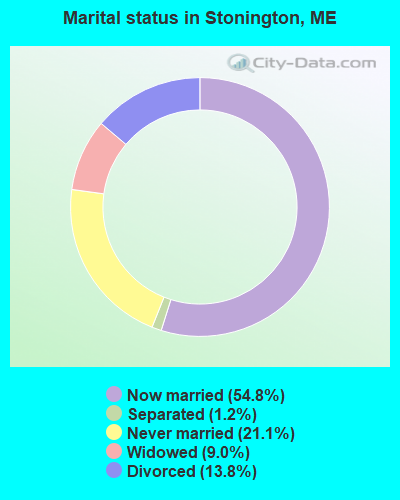
- Never married: 21.1%
- Now married: 54.8%
- Separated: 1.2%
- Widowed: 9.0%
- Divorced: 13.8%
For population 25 years and over in Stonington:
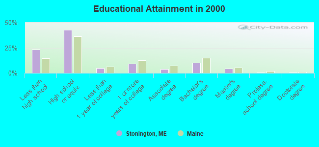
- High school or higher: 76.7%
- Bachelor's degree or higher: 15.6%
- Graduate or professional degree: 5.3%
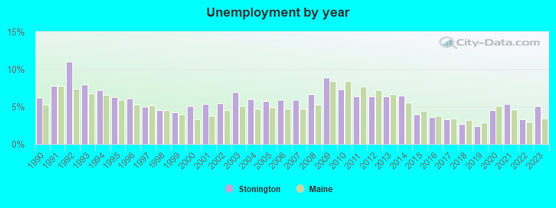
- Unemployed: 6.6%
- Mean travel time to work (commute): 14.5 minutes
| Here: | 11.5 |
| Maine average: | 11.2 |


Graphs represent county-level data. Detailed 2008 Election Results
Religion statistics for Stonington, ME (based on Hancock County data)


| Religion | Adherents | Congregations |
|---|---|---|
| Mainline Protestant | 4,691 | 58 |
| Catholic | 2,523 | 9 |
| Evangelical Protestant | 1,288 | 23 |
| Other | 820 | 11 |
| None | 45,096 | - |
Food Environment Statistics:
| This county: | 6.01 / 10,000 pop. |
| State: | 2.80 / 10,000 pop. |
| This county: | 1.69 / 10,000 pop. |
| Maine: | 2.20 / 10,000 pop. |
| Hancock County: | 4.89 / 10,000 pop. |
| State: | 5.75 / 10,000 pop. |
| This county: | 21.61 / 10,000 pop. |
| Maine: | 11.02 / 10,000 pop. |
| Hancock County: | 7.4% |
| Maine: | 8.2% |
| Here: | 25.4% |
| Maine: | 25.0% |
Businesses in Stonington, ME
- Ace Hardware: 1
Strongest AM radio stations in Stonington:
- WDEA (1370 AM; 5 kW; ELLSWORTH, ME; Owner: CUMULUS LICENSING CORP.)
- WZON (620 AM; 5 kW; BANGOR, ME; Owner: THE ZONE CORPORATION)
- WABI (910 AM; 5 kW; BANGOR, ME; Owner: CLEAR CHANNEL BROADCASTING LICENSES, INC.)
- WRKO (680 AM; 50 kW; BOSTON, MA; Owner: ENTERCOM BOSTON LICENSE, LLC)
- WSKW (1160 AM; 10 kW; SKOWHEGAN, ME; Owner: MOUNTAIN WIRELESS, INCORPORATED)
- WEEI (850 AM; 50 kW; BOSTON, MA; Owner: ENTERCOM BOSTON LICENSE, LLC)
- WBZ (1030 AM; 50 kW; BOSTON, MA; Owner: INFINITY BROADCASTING OPERATIONS, INC.)
- WTME (780 AM; 10 kW; RUMFORD, ME; Owner: MOUNTAIN VALLEY BROADCASTING, INC.)
- WCRN (830 AM; 50 kW; WORCESTER, MA; Owner: CARTER BROADCASTING CORPORATION)
- WRKD (1450 AM; 1 kW; ROCKLAND, ME; Owner: CLEAR CHANNEL BROADCASTING LICENSES, INC.)
- WFAU (1280 AM; 5 kW; GARDINER, ME; Owner: CAPSTAR TX LIMITED PARTNERSHIP)
- WNNZ (640 AM; 50 kW; WESTFIELD, MA; Owner: CLEAR CHANNEL BROADCASTING LICENSES, INC.)
- WMTW (870 AM; 10 kW; GORHAM, ME; Owner: RADIO PARTNERS OF MAINE, L.P.)
Strongest FM radio stations in Stonington:
- WERU-FM (89.9 FM; BLUE HILL, ME; Owner: SALT POND COMMUNITY B/C COMPANY)
- WMEP (90.5 FM; CAMDEN, ME; Owner: MAINE PUBLIC BROADCASTING CORP.)
- WFZX (101.7 FM; SEARSPORT, ME; Owner: CLEAR CHANNEL BROADCASTING LICENSES, INC.)
- WQSS (102.5 FM; CAMDEN, ME; Owner: CLEAR CHANNEL BROADCASTING LICENSES, INC.)
- WBFB (104.7 FM; BELFAST, ME; Owner: CLEAR CHANNEL BROADCASTING LICENSES, INC.)
- WMCM (103.3 FM; ROCKLAND, ME; Owner: CLEAR CHANNEL BROADCASTING LICENSES, INC.)
- WWMJ (95.7 FM; ELLSWORTH, ME; Owner: CUMULUS LICENSING CORP.)
- WBQX (106.9 FM; THOMASTON, ME; Owner: MARINER BROADCASTING LIMITED PARTNER)
- WWBX (97.1 FM; BANGOR, ME; Owner: CLEAR CHANNEL BROADCASTING LICENSES, INC.)
- WKIT-FM (100.3 FM; BREWER, ME; Owner: THE ZONE CORPORATION)
- WNSX (97.7 FM; WINTER HARBOR, ME; Owner: CLEAR CHANNEL BROADCASTING LICENSES, INC.)
- WBYA (105.5 FM; ISLESBORO, ME; Owner: MARINER BROADCASTING LIMTED PARTNERSHIP)
- WMEH (90.9 FM; BANGOR, ME; Owner: MAINE PUBLIC BROADCASTING CORPORATION)
- WLKE (99.1 FM; BAR HARBOR, ME; Owner: CLEAR CHANNEL BROADCASTING LICENSES, INC.)
Stonington fatal accident list:
Nov 1, 1999 10:00 PM, Ocean St, Vehicles: 1, Persons: 1, Fatalities: 1
Dec 23, 1999 09:10 PM, Airport Rd, Vehicles: 1, Persons: 5, Fatalities: 1
Jun 4, 1991 07:35 PM, 15a, Vehicles: 1, Persons: 2, Fatalities: 2, Drunk persons involved: 1
Feb 22, 1979 06:40 PM, Vehicles: 1, Persons: 2, Fatalities: 1
- National Bridge Inventory (NBI) Statistics
- 2Number of bridges
- 10ft / 2.6mTotal length
- 3,691Total average daily traffic
- 184Total average daily truck traffic
- 5,273Total future (year 2036) average daily traffic
FCC Registered Antenna Towers:
11 (See the full list of FCC Registered Antenna Towers in Stonington)FCC Registered Broadcast Land Mobile Towers:
2- Cemetary Rd (Lat: 44.162806 Lon: -68.665750), Type: Ltower, Structure height: 54.9 m, Overall height: 57.9 m, Call Sign: KNHD598,
Assigned Frequencies: 155.820 MHz, Grant Date: 02/15/2024, Expiration Date: 04/27/2034, Certifier: Adelbert F Gross, Registrant: Browns Communications, Inc, 162 Bangor Rd, Suite B, Ellsworth, ME 04605, Phone: (207) 667-2254, Email:
- 10 Bayview St (Lat: 44.155639 Lon: -68.657528), Call Sign: KNCS660, Licensee ID: L00057686,
Assigned Frequencies: 151.775 MHz, Grant Date: 11/22/1996, Expiration Date: 01/21/2002, Cancellation Date: 05/05/2002, Registrant: Village Electronics, Clark Point Rd, Southwest Harbor, ME 04675, Phone: (207) 244-7227
FCC Registered Microwave Towers:
1- STONINGTON, St Hwy 15, .5 Mi. N Of (Lat: 44.158556 Lon: -68.659889), Type: Ltower, Structure height: 45.7 m, Overall height: 46 m, Call Sign: WLU547,
Assigned Frequencies: 11405.0 MHz, 11405.0 MHz, 11405.0 MHz, 11405.0 MHz, 11645.0 MHz, 11645.0 MHz, 11645.0 MHz, 11645.0 MHz, 6078.62 MHz, 6078.62 MHz... (+62 more), Grant Date: 02/02/2021, Expiration Date: 02/01/2031, Registrant: Intelpath, Hinsdale, IL 60522, Phone: (312) 841-9188, Email:
FCC Registered Maritime Coast & Aviation Ground Towers:
6- Moose Island Rd (Lat: 44.141750 Lon: -68.699472), Type: Building, Overall height: 15 m, Call Sign: KSK308,
Assigned Frequencies: 156.450 MHz, 156.500 MHz, 156.800 MHz, Grant Date: 11/02/2023, Expiration Date: 11/04/2033, Registrant: Billings Diesel & Marine Service, 72 Moose Island Causeway, Stonington, ME 04681, Phone: (207) 367-2328, Fax: (207) 367-5925, Email:
- Highland Ave (Lat: 44.155639 Lon: -68.670306), Type: Building, Overall height: 4 m, Call Sign: KTR845, Licensee ID: L00563615,
Assigned Frequencies: 156.450 MHz, 156.800 MHz, Grant Date: 11/26/2002, Expiration Date: 10/23/2012, Cancellation Date: 12/29/2012, Registrant: Lawrence Bray Jr, Highland Ave, Stonington, ME 04681
- W Main St Stonington Harbor Front (Lat: 44.149250 Lon: -68.672528), Type: Building, Overall height: 11 m, Call Sign: WHW362,
Assigned Frequencies: 156.425 MHz, 156.450 MHz, 156.800 MHz, Grant Date: 06/22/1994, Expiration Date: 06/22/1999, Cancellation Date: 05/06/2001, Registrant: Andrew U Gore, W Main St, Stonington, ME 04681
- Stanleyfield Rd S Deer Isle (Lat: 44.192306 Lon: -68.663361), Type: Building, Overall height: 4 m, Call Sign: WHW474,
Assigned Frequencies: 156.425 MHz, 156.450 MHz, 156.800 MHz, Grant Date: 06/22/1994, Expiration Date: 06/22/1999, Cancellation Date: 05/06/2001, Registrant: Laura E Hutchinson, Stanleyfield Rd, Stonington, ME 04681
- W Main St (Lat: 44.150083 Lon: -68.699472), Type: Building, Overall height: 9 m, Call Sign: WRD576,
Assigned Frequencies: 156.425 MHz, 156.500 MHz, 156.450 MHz, 156.800 MHz, Grant Date: 01/20/2021, Expiration Date: 03/27/2031, Registrant: Island Fishing Gear, Inc, 8 West Main St, Stonington, ME 04681, Phone: (207) 367-5959
- 1 Granite St (Lat: 44.155361 Lon: -68.659472), Type: Building, Overall height: 5 m, Call Sign: WXZ480,
Assigned Frequencies: 156.450 MHz, 156.500 MHz, 156.800 MHz, 156.925 MHz, Grant Date: 02/16/1999, Expiration Date: 04/05/2004, Cancellation Date: 06/06/2004, Registrant: Blaine Blackmore, 1 Granite St, Stonington, ME 04681
FCC Registered Amateur Radio Licenses:
7- Call Sign: KA1PXT, Grant Date: 04/18/1989, Expiration Date: 04/18/1999, Cancellation Date: 04/19/2001, Registrant: Lowell A Kent, 103 Thurlows Hill, Stonington, ME 04681
- Call Sign: KA1YMT, Grant Date: 04/02/1991, Expiration Date: 04/02/2001, Cancellation Date: 04/03/2003, Registrant: Jeremy M Rissi, Rfd 1 Box 1779, Stonington, ME 04681
- Call Sign: N1XVH, Grant Date: 09/12/1996, Expiration Date: 09/12/2006, Cancellation Date: 09/13/2008, Registrant: Erlene E Davis, Rfd 1 Box 1810, Stonington, ME 04681
- Call Sign: NA1K, Licensee ID: L00983708, Grant Date: 04/21/2015, Expiration Date: 05/04/2025, Certifier: John E Clifford, Registrant: John E Clifford, Stonington, ME 04681-0267
- Call Sign: W1HSO, Previous Call Sign: N1GJW, Grant Date: 06/04/1996, Expiration Date: 06/04/2006, Cancellation Date: 06/05/2008, Registrant: Wendell D Davis, Rfd 1 Box 1810, Stonington, ME 04681
- Call Sign: KB1HBG, Licensee ID: L00381966, Grant Date: 06/10/2011, Expiration Date: 07/24/2021, Cancellation Date: 10/03/2015, Certifier: Joseph W Sullivan, Registrant: Joseph W Sullivan, Stonington, ME 04681
- Call Sign: KB1VHU, Licensee ID: L01623368, Grant Date: 03/09/2011, Expiration Date: 03/09/2021, Cancellation Date: 03/10/2023, Certifier: Erik A Walter, Registrant: Erik A Walter, Stonington, ME 04681
FAA Registered Aircraft:
2- Aircraft: GOSSARD PHILIP G VANS RV-4 (Category: Land, Seats: 2, Weight: Up to 12,499 Pounds), Engine: LYCOMING O&VO-360 SER (180 HP) (Reciprocating)
N-Number: 47RG, N47RG, N-47RG, Serial Number: 3290, Year manufactured: 1994, Airworthiness Date: 08/03/1994, Certificate Issue Date: 11/16/1993
Registrant (Individual): Philip G Gossard, 741 Oceanville Rd, Stonington, ME 04681 - Aircraft: CESSNA 150F (Category: Land, Seats: 2, Weight: Up to 12,499 Pounds, Speed: 90 mph), Engine: CONT MOTOR 0-200 SERIES (100 HP) (Reciprocating)
N-Number: 6580F, N6580F, N-6580F, Serial Number: 15063180, Year manufactured: 1966, Airworthiness Date: 02/25/1966, Certificate Issue Date: 09/21/2018
Registrant (Individual): Herbert E Jones, 206 Indian Point Rd, Stonington, ME 04681
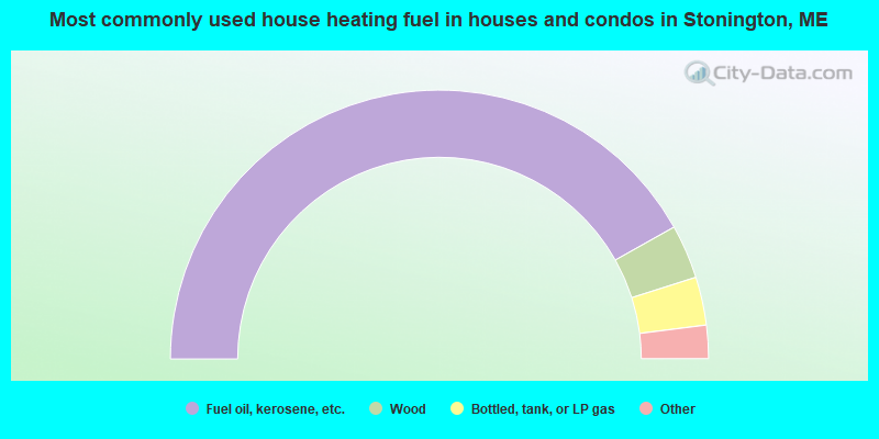
- 83.7%Fuel oil, kerosene, etc.
- 6.5%Wood
- 5.8%Bottled, tank, or LP gas
- 3.0%Electricity
- 1.0%Other fuel
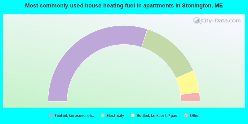
- 60.0%Fuel oil, kerosene, etc.
- 26.7%Electricity
- 9.5%Bottled, tank, or LP gas
- 1.9%Wood
- 1.9%No fuel used
Stonington compared to Maine state average:
- Unemployed percentage below state average.
- Black race population percentage significantly below state average.
- Hispanic race population percentage significantly below state average.
- Median age above state average.
- Foreign-born population percentage below state average.
- Length of stay since moving in significantly above state average.
- Number of rooms per house significantly below state average.
- House age significantly below state average.
- Number of college students below state average.
- Percentage of population with a bachelor's degree or higher below state average.

|
Total of 1 patent application in 2008-2024.