Stockbridge, New York

Stockbridge: Alive
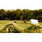
Stockbridge: Typical Stockbridge Sight!
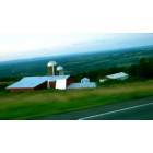
Stockbridge: Peterborough Road Drive..
- add
your
Submit your own pictures of this town and show them to the world
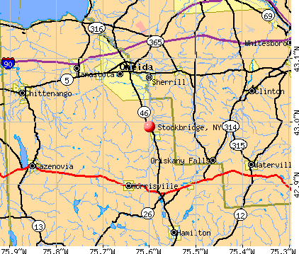
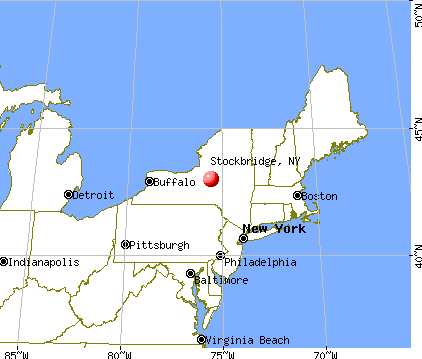
- OSM Map
- General Map
- Google Map
- MSN Map
Population change since 2000: +1.1%
 |
| Males: 1,066 | |
| Females: 1,037 |
| Median resident age: | 38.3 years |
| New York median age: | 40.7 years |
Zip codes: 13409.
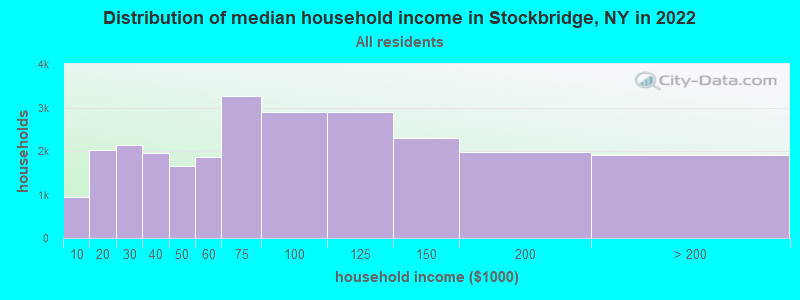
| Stockbridge: | $65,660 |
| NY: | $79,557 |
Estimated per capita income in 2022: $30,475 (it was $15,856 in 2000)
Stockbridge town income, earnings, and wages data
Estimated median house or condo value in 2022: $141,408 (it was $67,900 in 2000)
| Stockbridge: | $141,408 |
| NY: | $400,400 |
Mean prices in 2022: all housing units: $228,996; detached houses: $251,711; townhouses or other attached units: $223,213; in 2-unit structures: $190,364; in 3-to-4-unit structures: $208,959; in 5-or-more-unit structures: $313,705; mobile homes: $82,599
Detailed information about poverty and poor residents in Stockbridge, NY


- 2,01495.8%White alone
- 381.8%American Indian alone
- 241.1%Two or more races
- 160.8%Hispanic
- 60.3%Asian alone
- 40.2%Black alone
- 10.05%Other race alone

Races in Stockbridge detailed stats: ancestries, foreign born residents, place of birth
 Recent articles from our blog. Our writers, many of them Ph.D. graduates or candidates, create easy-to-read articles on a wide variety of topics.


Latest news from Stockbridge, NY collected exclusively by city-data.com from local newspapers, TV, and radio stations
Ancestries: German (23.3%), Irish (18.5%), English (18.1%), French (10.0%), United States (6.5%), Italian (6.4%).
Current Local Time: EST time zone
Land area: 31.7 square miles.
Population density: 66 people per square mile (very low).
30 residents are foreign born
| This town: | 1.4% |
| New York: | 20.4% |
| Stockbridge town: | 1.9% ($1,313) |
| New York: | 1.9% ($2,847) |
Nearest city with pop. 50,000+: Utica, NY  (19.7 miles , pop. 60,651).
Nearest city with pop. 200,000+: Rochester, NY (103.0 miles , pop. 219,773).
Nearest city with pop. 1,000,000+: Bronx, NY (172.0 miles , pop. 1,332,650).
Nearest cities:
), ), ), )Latitude: 42.98 N, Longitude: 75.59 W
Area code commonly used in this area: 315

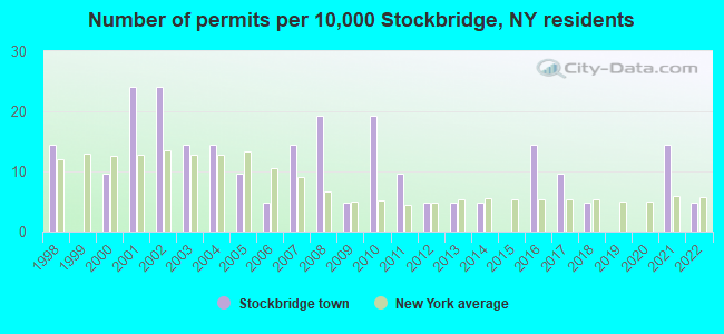
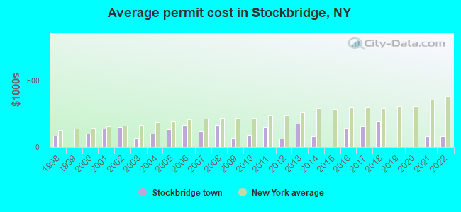
Single-family new house construction building permits:
- 2022: 1 building, cost: $80,000
- 2021: 3 buildings, average cost: $80,000
- 2018: 1 building, cost: $200,000
- 2017: 2 buildings, average cost: $156,000
- 2016: 3 buildings, average cost: $141,700
- 2014: 1 building, cost: $80,000
- 2013: 1 building, cost: $175,000
- 2012: 1 building, cost: $63,400
- 2011: 2 buildings, average cost: $150,000
- 2010: 4 buildings, average cost: $90,500
- 2009: 1 building, cost: $70,000
- 2008: 4 buildings, average cost: $162,500
- 2007: 3 buildings, average cost: $118,300
- 2006: 1 building, cost: $163,600
- 2005: 2 buildings, average cost: $131,500
- 2004: 3 buildings, average cost: $101,700
- 2003: 3 buildings, average cost: $71,300
- 2002: 5 buildings, average cost: $147,500
- 2001: 5 buildings, average cost: $139,700
- 2000: 2 buildings, average cost: $100,000
- 1998: 3 buildings, average cost: $83,300
| Here: | 4.4% |
| New York: | 4.4% |
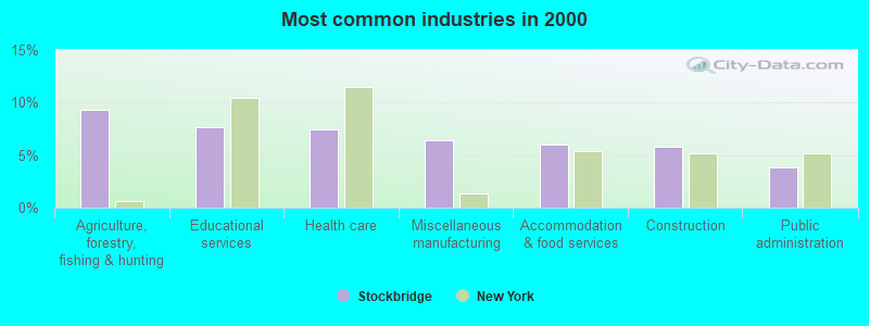
- Agriculture, forestry, fishing & hunting (9.3%)
- Educational services (7.7%)
- Health care (7.5%)
- Miscellaneous manufacturing (6.5%)
- Accommodation & food services (6.1%)
- Construction (5.7%)
- Public administration (3.8%)
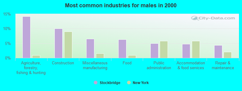
- Agriculture, forestry, fishing & hunting (14.2%)
- Construction (10.1%)
- Miscellaneous manufacturing (6.5%)
- Food (6.3%)
- Public administration (4.9%)
- Accommodation & food services (4.7%)
- Repair & maintenance (4.3%)
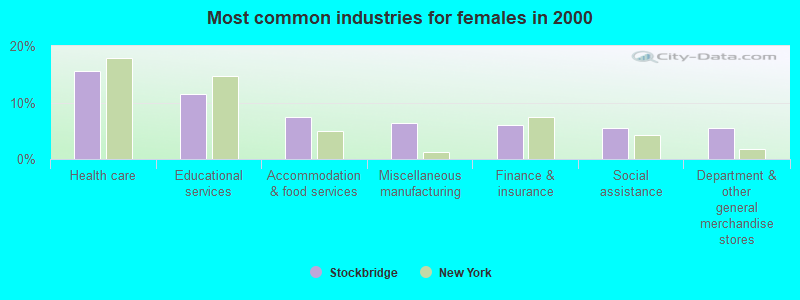
- Health care (15.6%)
- Educational services (11.5%)
- Accommodation & food services (7.5%)
- Miscellaneous manufacturing (6.4%)
- Finance & insurance (6.0%)
- Social assistance (5.6%)
- Department & other general merchandise stores (5.6%)
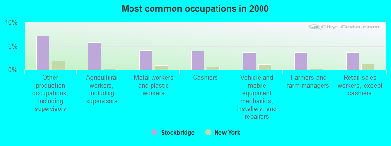
- Other production occupations, including supervisors (7.2%)
- Agricultural workers, including supervisors (5.7%)
- Metal workers and plastic workers (4.1%)
- Cashiers (4.0%)
- Vehicle and mobile equipment mechanics, installers, and repairers (3.7%)
- Farmers and farm managers (3.7%)
- Retail sales workers, except cashiers (3.7%)
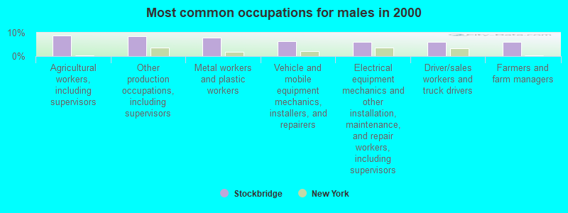
- Agricultural workers, including supervisors (8.9%)
- Other production occupations, including supervisors (8.5%)
- Metal workers and plastic workers (7.9%)
- Vehicle and mobile equipment mechanics, installers, and repairers (6.3%)
- Electrical equipment mechanics and other installation, maintenance, and repair workers, including supervisors (6.1%)
- Driver/sales workers and truck drivers (6.1%)
- Farmers and farm managers (5.9%)
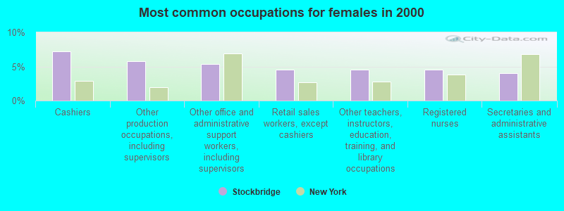
- Cashiers (7.3%)
- Other production occupations, including supervisors (5.8%)
- Other office and administrative support workers, including supervisors (5.3%)
- Retail sales workers, except cashiers (4.5%)
- Other teachers, instructors, education, training, and library occupations (4.5%)
- Registered nurses (4.5%)
- Secretaries and administrative assistants (4.1%)
Average climate in Stockbridge, New York
Based on data reported by over 4,000 weather stations


(lower is better)
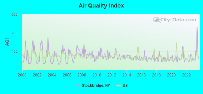
Air Quality Index (AQI) level in 2023 was 94.7. This is worse than average.
| City: | 94.7 |
| U.S.: | 72.6 |
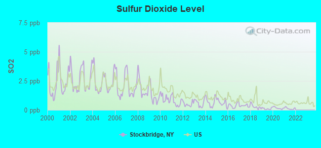
Sulfur Dioxide (SO2) [ppb] level in 2021 was 0.128. This is significantly better than average. Closest monitor was 17.3 miles away from the city center.
| City: | 0.128 |
| U.S.: | 1.515 |
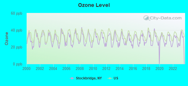
Ozone [ppb] level in 2023 was 30.9. This is about average. Closest monitor was 20.0 miles away from the city center.
| City: | 30.9 |
| U.S.: | 33.3 |
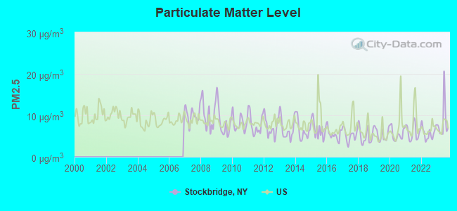
Particulate Matter (PM2.5) [µg/m3] level in 2023 was 8.50. This is about average. Closest monitor was 20.1 miles away from the city center.
| City: | 8.50 |
| U.S.: | 8.11 |
Tornado activity:
Stockbridge-area historical tornado activity is below New York state average. It is 74% smaller than the overall U.S. average.
On 5/2/1983, a category F3 (max. wind speeds 158-206 mph) tornado 33.1 miles away from the Stockbridge town center killed one person and caused between $500,000 and $5,000,000 in damages.
On 5/2/1983, a category F3 tornado 36.2 miles away from the town center caused between $5,000,000 and $50,000,000 in damages.
Earthquake activity:
Stockbridge-area historical earthquake activity is significantly above New York state average. It is 68% smaller than the overall U.S. average.On 10/7/1983 at 10:18:46, a magnitude 5.3 (5.1 MB, 5.3 LG, 5.1 ML, Class: Moderate, Intensity: VI - VII) earthquake occurred 91.8 miles away from the city center
On 4/20/2002 at 10:50:47, a magnitude 5.3 (5.3 ML, Depth: 3.0 mi) earthquake occurred 141.9 miles away from the city center
On 4/20/2002 at 10:50:47, a magnitude 5.2 (5.2 MB, 4.2 MS, 5.2 MW, 5.0 MW) earthquake occurred 140.0 miles away from Stockbridge center
On 8/23/2011 at 17:51:04, a magnitude 5.8 (5.8 MW, Depth: 3.7 mi) earthquake occurred 371.9 miles away from the city center
On 9/25/1998 at 19:52:52, a magnitude 5.2 (4.8 MB, 4.3 MS, 5.2 LG, 4.5 MW, Depth: 3.1 mi) earthquake occurred 266.9 miles away from the city center
On 6/17/1991 at 08:53:16, a magnitude 4.1 (4.0 MB, 4.0 LG, Depth: 3.1 mi, Class: Light, Intensity: IV - V) earthquake occurred 52.2 miles away from Stockbridge center
Magnitude types: regional Lg-wave magnitude (LG), body-wave magnitude (MB), local magnitude (ML), surface-wave magnitude (MS), moment magnitude (MW)
Natural disasters:
The number of natural disasters in Madison County (21) is greater than the US average (15).Major Disasters (Presidential) Declared: 13
Emergencies Declared: 6
Causes of natural disasters: Storms: 11, Floods: 9, Hurricanes: 2, Snowstorms: 2, Tornadoes: 2, Winds: 2, Blizzard: 1, Heavy Rain: 1, Ice Storm: 1, Landslide: 1, Power Outage: 1, Tropical Storm: 1, Winter Storm: 1, Other: 2 (Note: some incidents may be assigned to more than one category).
Hospitals and medical centers near Stockbridge:
- CROUSE COMMUNITY CENTER INC (Nursing Home, about 7 miles away; MORRISVILLE, NY)
- ONEIDA HEALTHCARE CENTER Acute Care Hospitals (about 8 miles away; ONEIDA, NY)
- FAXTON ST. LUKE'S HEALTHCARE - ONEIDA (Dialysis Facility, about 9 miles away; ONEIDA, NY)
- FAXTON ST LUKE'S HEALTHCARE - HAMILTON (Dialysis Facility, about 11 miles away; HAMILTON, NY)
- HARDING NURSING HOME (Nursing Home, about 11 miles away; WATERVILLE, NY)
- COMMUNITY MEMORIAL HOSPITAL, INC Acute Care Hospitals (about 12 miles away; HAMILTON, NY)
- KATHERINE LUTHER RESIDENTIAL HLTH CARE AND REHAB (Nursing Home, about 13 miles away; CLINTON, NY)
Colleges/universities with over 2000 students nearest to Stockbridge:
- Morrisville State College (about 7 miles; Morrisville, NY; Full-time enrollment: 2,823)
- Colgate University (about 12 miles; Hamilton, NY; FT enrollment: 3,094)
- Utica College (about 18 miles; Utica, NY; FT enrollment: 2,952)
- Mohawk Valley Community College (about 20 miles; Utica, NY; FT enrollment: 5,693)
- Le Moyne College (about 26 miles; Syracuse, NY; FT enrollment: 3,041)
- Syracuse University (about 29 miles; Syracuse, NY; FT enrollment: 20,717)
- SUNY College of Environmental Science and Forestry (about 29 miles; Syracuse, NY; FT enrollment: 2,044)
Points of interest:
Notable locations in Stockbridge: The Oxbow (A), Bridges Corners (B). Display/hide their locations on the map
Church in Stockbridge: Saint Theresa Catholic Church (A). Display/hide its location on the map
Cemeteries: West Hill Cemetery (1), Munnsville Village Cemetery (2), Bridge Cemetery (3), Stock Bridge Cemetery (4), Stockbridge Cemetery (5), Cummings Cemetery (6). Display/hide their locations on the map
Creek: Blue Creek (A). Display/hide its location on the map
Birthplace of: Philip Danforth Armour - Businessman.
| This town: | 2.6 people |
| New York: | 2.6 people |
| This town: | 71.8% |
| Whole state: | 63.5% |
| This town: | 10.7% |
| Whole state: | 6.8% |
Likely homosexual households (counted as self-reported same-sex unmarried-partner households)
- Lesbian couples: 0.2% of all households
- Gay men: 0.1% of all households
| This town: | 12.9% |
| Whole state: | 14.6% |
| This town: | 4.7% |
| Whole state: | 7.4% |
For population 15 years and over in Stockbridge:
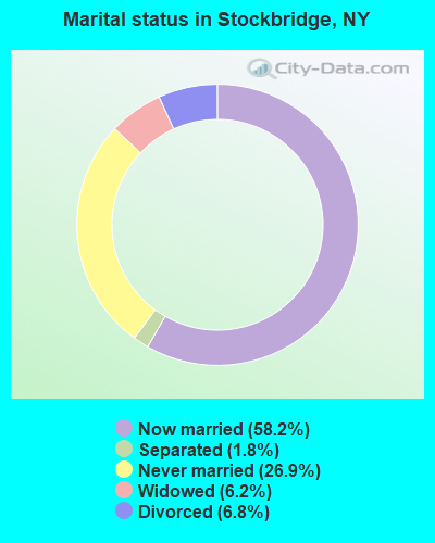
- Never married: 26.9%
- Now married: 58.2%
- Separated: 1.8%
- Widowed: 6.2%
- Divorced: 6.8%
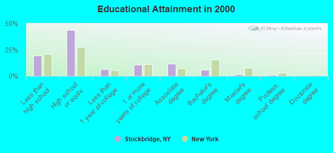
For population 25 years and over in Stockbridge:
- High school or higher: 80.5%
- Bachelor's degree or higher: 8.4%
- Graduate or professional degree: 2.7%
- Unemployed: 5.5%
- Mean travel time to work (commute): 23.9 minutes
| Here: | 9.3 |
| New York average: | 14.2 |
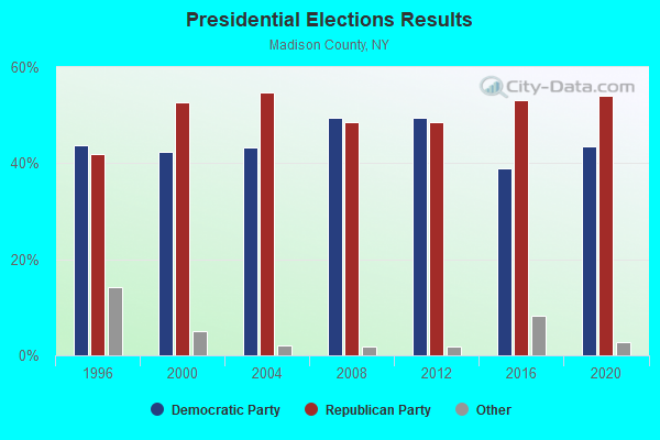
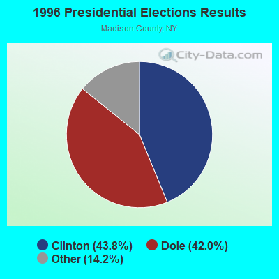
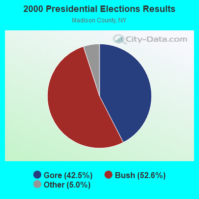
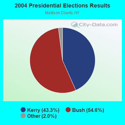
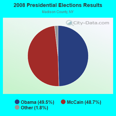
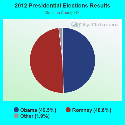
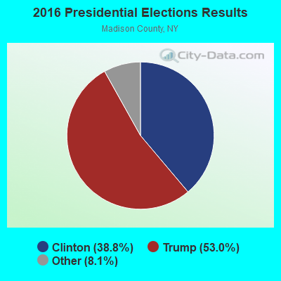
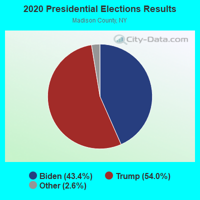
Graphs represent county-level data. Detailed 2008 Election Results
Religion statistics for Stockbridge, NY (based on Madison County data)
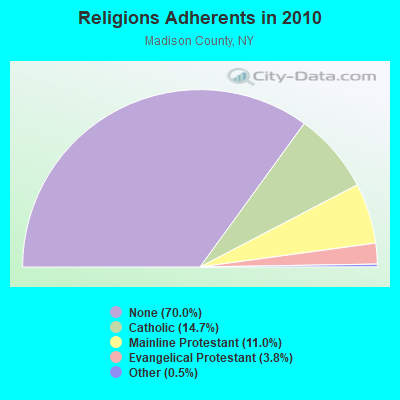
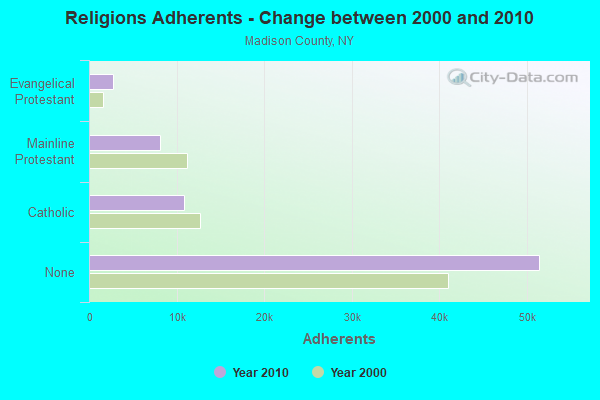
| Religion | Adherents | Congregations |
|---|---|---|
| Catholic | 10,810 | 9 |
| Mainline Protestant | 8,060 | 45 |
| Evangelical Protestant | 2,780 | 28 |
| Other | 358 | 6 |
| None | 51,434 | - |
Food Environment Statistics:
| Here: | 2.15 / 10,000 pop. |
| State: | 4.13 / 10,000 pop. |
| Madison County: | 0.14 / 10,000 pop. |
| New York: | 0.06 / 10,000 pop. |
| Madison County: | 0.57 / 10,000 pop. |
| New York: | 0.92 / 10,000 pop. |
| Here: | 2.72 / 10,000 pop. |
| State: | 1.68 / 10,000 pop. |
| Madison County: | 8.30 / 10,000 pop. |
| New York: | 8.82 / 10,000 pop. |
| Madison County: | 7.4% |
| New York: | 8.2% |
| Madison County: | 26.6% |
| New York: | 23.8% |
| This county: | 15.9% |
| State: | 15.6% |
Strongest AM radio stations in Stockbridge:
- WIBX (950 AM; 5 kW; UTICA, NY; Owner: REGENT LICENSEE OF UTICA/ROME, INC.)
- WTLB (1310 AM; 5 kW; UTICA, NY; Owner: GALAXY COMMUNICATIONS, L.P.)
- WRUN (1150 AM; 5 kW; UTICA, NY)
- WSYR (570 AM; 5 kW; SYRACUSE, NY; Owner: CLEAR CHANNEL BROADCASTING LICENSES, INC.)
- WGY (810 AM; 50 kW; SCHENECTADY, NY; Owner: CLEAR CHANNEL BROADCASTING LICENSES, INC.)
- WMCR (1600 AM; 1 kW; ONEIDA, NY; Owner: WARREN BROADCASTING COMPANY, INC.)
- WHEN (620 AM; 5 kW; SYRACUSE, NY; Owner: CLEAR CHANNEL BROADCASTING LICENSES, INC.)
- WNSS (1260 AM; 5 kW; SYRACUSE, NY; Owner: CITADEL BROADCASTING COMPANY)
- WPTR (1540 AM; 50 kW; ALBANY, NY; Owner: KIMTRON, INC.)
- WHAM (1180 AM; 50 kW; ROCHESTER, NY; Owner: CITICASTERS LICENSES, L.P.)
- WADR (1480 AM; 5 kW; REMSEN, NY; Owner: CLEAR CHANNEL BROADCASTING LICENSES, INC.)
- WDCW (1390 AM; 5 kW; SYRACUSE, NY; Owner: KIMTRON, INC.)
- WNNZ (640 AM; 50 kW; WESTFIELD, MA; Owner: CLEAR CHANNEL BROADCASTING LICENSES, INC.)
Strongest FM radio stations in Stockbridge:
- WMCR-FM (106.3 FM; ONEIDA, NY; Owner: WARREN BROADCASTING CO. INC.)
- WSKS (97.9 FM; WHITESBORO, NY; Owner: CLEAR CHANNEL BROADCASTING LICENSES, INC.)
- WRBY (102.5 FM; ROME, NY; Owner: CLEAR CHANNEL BROADCASTING LICENSES, INC.)
- WWDG (105.1 FM; DERUYTER, NY; Owner: CLEAR CHANNEL BROADCASTING LICENSES, INC.)
- WFRG-FM (104.3 FM; UTICA, NY; Owner: REGENT LICENSEE OF UTICA/ROME, INC.)
- WXXE (90.5 FM; FENNER, NY; Owner: SYRACUSE COMMUNITY RADIO, INC.)
- WODZ-FM (96.1 FM; ROME, NY; Owner: REGENT LICENSEE OF UTICA/ROME, INC.)
- WKVU (100.7 FM; UTICA, NY; Owner: EDUCATIONAL MEDIA FOUNDATION)
- WCNY-FM (91.3 FM; SYRACUSE, NY; Owner: THE PUB. B/C COUNC. OF CEN. NY, INC.)
- WOUR (96.9 FM; UTICA, NY; Owner: CLEAR CHANNEL BROADCASTING LICENSES, INC.)
- WUNY (89.5 FM; UTICA, NY; Owner: PUBLIC BC COUNCIL OF CENTRAL NY, INC)
- WNTQ (93.1 FM; SYRACUSE, NY; Owner: CITADEL BROADCASTING COMPANY)
- WLZW (98.7 FM; UTICA, NY; Owner: REGENT LICENSEE OF UTICA/ROME, INC.)
- WKLL (94.9 FM; FRANKFORT, NY; Owner: GALAXY COMMUNICATIONS, L.P.)
- WMHR (102.9 FM; SYRACUSE, NY; Owner: MARS HILL BROADCASTING CO., INC.)
- WYYY (94.5 FM; SYRACUSE, NY; Owner: CLEAR CHANNEL BROADCASTING LICENSES, INC.)
- WUCL (93.5 FM; REMSEN, NY; Owner: CLEAR CHANNEL BROADCASTING LICENSES, INC.)
- WRCK (107.3 FM; UTICA, NY; Owner: GALAXY COMMUNICATIONS, L.P.)
- WBGK (99.7 FM; NEWPORT VILLAGE, NY; Owner: ROSER COMMUNICATIONS NETWORK, INC.)
- W257BE (99.3 FM; HAMILTON, NY; Owner: BANJO COMMUNICATIONS GROUP, INC)
TV broadcast stations around Stockbridge:
- WFXV (Channel 33; UTICA, NY; Owner: QUORUM OF UTICA LICENSE, LLC)
- WIXT-TV (Channel 9; SYRACUSE, NY; Owner: CENTRAL NY NEWS, INC.)
- WCNY-TV (Channel 24; SYRACUSE, NY; Owner: PUBLIC BROADCASTING COUNCIL OF CENTRAL NEW YORK)
- WSTM-TV (Channel 3; SYRACUSE, NY; Owner: WSTM LICENSE SUBSIDIARY, INC.)
- WNYS-TV (Channel 43; SYRACUSE, NY; Owner: RKM MEDIA, INC.)
- W15BR (Channel 15; ONEIDA, NY; Owner: RENARD COMMUNICATIONS CORP.)
- WKTV (Channel 2; UTICA, NY; Owner: SMITH TELEVISION OF NEW YORK LICENSE HOLDINGS, INC.)
- WSPX-TV (Channel 56; SYRACUSE, NY; Owner: PAXSON SYRACUSE LICENSE, INC.)
- W13BR (Channel 13; ONEIDA, NY; Owner: KEVIN O'KANE)
- WSYT (Channel 68; SYRACUSE, NY; Owner: WSYT LICENSEE L.P.)
- WTVH (Channel 5; SYRACUSE, NY; Owner: WTVH LICENSE, INC.)
- W59AU (Channel 59; UTICA, NY; Owner: PUBLIC B/CING.COUNCIL,CENTRAL N. Y.)
- W12BZ (Channel 12; ROME, NY; Owner: KEVIN O'KANE)
- WUTR (Channel 20; UTICA, NY; Owner: CENTRAL NY NEWS, INC.)
- WPNY-LP (Channel 11; UTICA, ETC., NY; Owner: QUORUM OF UTICA LICENSE, LLC)
- W51BA (Channel 51; SYRACUSE, NY; Owner: RENARD COMMUNICATIONS CORP.)
- WNDR-LP (Channel 18; SYRACUSE, NY; Owner: METRO TV, INC.)
- W53AM (Channel 53; UTICA, NY; Owner: QUORUM OF UTICA LICENSE, LLC)
- National Bridge Inventory (NBI) Statistics
- 4Number of bridges
- 20ft / 5.8mTotal length
- $1,454,000Total costs
- 1,729Total average daily traffic
- 145Total average daily truck traffic
- 2,421Total future (year 2036) average daily traffic
FCC Registered Microwave Towers:
1- UP30832A, Smith Rd (Lat: 42.996972 Lon: -75.613306), Type: Ltower, Structure height: 57.9 m, Call Sign: WRXM630,
Assigned Frequencies: 10755.0 MHz, 10755.0 MHz, 10755.0 MHz, 10755.0 MHz, 10755.0 MHz, 10755.0 MHz, 10755.0 MHz, 10755.0 MHz, 10755.0 MHz, 10755.0 MHz... (+12 more), Grant Date: 05/31/2023, Expiration Date: 05/31/2033, Certifier: Jenny Knopf, Registrant: T-Mobile Usa, Inc., 12920 Se 38th Street, Bellevue, WA 98006, Phone: (425) 383-8401, Fax: (425) 383-4040, Email:
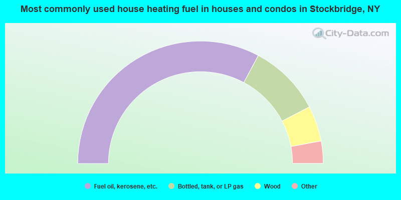
- 65.7%Fuel oil, kerosene, etc.
- 19.1%Bottled, tank, or LP gas
- 9.4%Wood
- 2.4%Utility gas
- 1.6%Other fuel
- 1.4%Electricity
- 0.5%Coal or coke
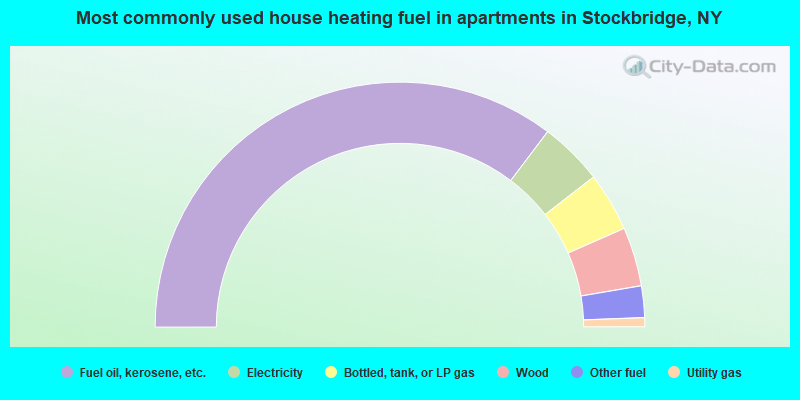
- 70.7%Fuel oil, kerosene, etc.
- 8.4%Electricity
- 7.8%Bottled, tank, or LP gas
- 7.8%Wood
- 4.2%Other fuel
- 1.2%Utility gas
Stockbridge compared to New York state average:
- Median house value significantly below state average.
- Unemployed percentage below state average.
- Black race population percentage significantly below state average.
- Hispanic race population percentage significantly below state average.
- Foreign-born population percentage significantly below state average.
- Renting percentage significantly below state average.
- Length of stay since moving in significantly above state average.
- Number of rooms per house significantly below state average.
- House age significantly below state average.
- Number of college students below state average.
- Percentage of population with a bachelor's degree or higher significantly below state average.