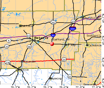
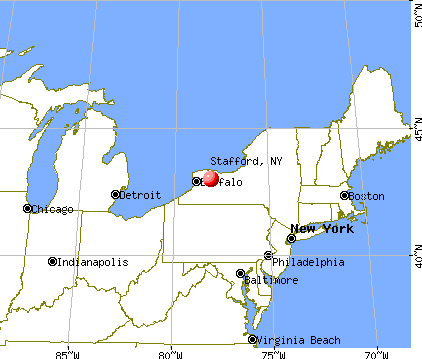
Stafford, New York
Submit your own pictures of this town and show them to the world
- OSM Map
- General Map
- Google Map
- MSN Map
Population change since 2000: +2.1%
 |
| Males: 1,240 | |
| Females: 1,219 |
| Median resident age: | 45.4 years |
| New York median age: | 40.7 years |
Zip codes: 14143.
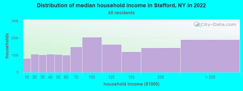
| Stafford: | $81,398 |
| NY: | $79,557 |
Estimated per capita income in 2022: $37,670 (it was $19,775 in 2000)
Stafford town income, earnings, and wages data
Estimated median house or condo value in 2022: $164,084 (it was $87,600 in 2000)
| Stafford: | $164,084 |
| NY: | $400,400 |
Mean prices in 2022: all housing units: $185,048; detached houses: $198,060; townhouses or other attached units: $337,040; in 2-unit structures: $169,572; in 3-to-4-unit structures: $91,733; in 5-or-more-unit structures: $222,028; mobile homes: $56,245; occupied boats, rvs, vans, etc.: $155,195
Detailed information about poverty and poor residents in Stafford, NY
Compare current foreclosures near Stafford, NY:
| Photo | Address | Area | Beds / Baths | Price | Details |
|---|---|---|---|---|---|

|
#1
Vernon Ave
Batavia, NY 14020
|
1,470 sq. feet
|
1 baths 3 beds |
$209,900
|
show details |

|
#2
North Street Rd
Le Roy, NY 14482
|
1,910 sq. feet
|
1 baths 3 beds |
show details | |

|
#3
Sierk Rd
Attica, NY 14011
|
- sq. feet
|
- baths - beds |
$43,900
|
show details |

|
#4
Hilltop Dr
Le Roy, NY 14482
|
960 sq. feet
|
2 baths 4 beds |
show details | |

|
#5
E Albion St
Holley, NY 14470
|
1,200 sq. feet
|
1 baths 3 beds |
show details | |

|
#6
Grandview Ter
Batavia, NY 14020
|
1,048 sq. feet
|
1 baths 3 beds |
show details | |

|
#7
Fordham Dr
Batavia, NY 14020
|
3,914 sq. feet
|
2 baths 4 beds |
show details | |

|
#8
Greenway Blvd
Churchville, NY 14428
|
924 sq. feet
|
1 baths 2 beds |
show details | |

|
#9
Cleveland Rd
Corfu, NY 14036
|
1,008 sq. feet
|
1 baths 3 beds |
show details | |

|
#10
Eagle Harbor Rd
Albion, NY 14411
|
2,106 sq. feet
|
1 baths 4 beds |
show details |
| Photo | Address | Area | Beds / Baths | Price | Details |
|---|---|---|---|---|---|

|
#11
Holley Byron Rd
Holley, NY 14470
|
1,234 sq. feet
|
1 baths 3 beds |
show details | |

|
#12
Colby Rd
Darien Center, NY 14040
|
1,056 sq. feet
|
1 baths 2 beds |
show details | |

|
#13
Bowen Rd
Churchville, NY 14428
|
2,134 sq. feet
|
2 baths 3 beds |
show details | |

|
#14
Genesee St
Corfu, NY 14036
|
936 sq. feet
|
1 baths 3 beds |
show details | |

|
#15
Fisher Rd
Oakfield, NY 14125
|
1,560 sq. feet
|
1 baths 3 beds |
show details | |

|
#16
Sweden Hill Rd
Brockport, NY 14420
|
2,052 sq. feet
|
2 baths 3 beds |
show details | |

|
#17
Brookview Rd
Rochester, NY 14624
|
1,116 sq. feet
|
1 baths 3 beds |
show details | |

|
#18
Cailyn Way
Brockport, NY 14420
|
1,880 sq. feet
|
2 baths 4 beds |
show details | |

|
#19
Lewiston Rd
Basom, NY 14013
|
728 sq. feet
|
1 baths 2 beds |
show details | |

|
#20
Meadowview Dr
Brockport, NY 14420
|
1,380 sq. feet
|
1 baths 4 beds |
show details |
| Photo | Address | Area | Beds / Baths | Price | Details |
|---|---|---|---|---|---|

|
#21
Briarwood Ln
Scottsville, NY 14546
|
1,408 sq. feet
|
2 baths 3 beds |
show details | |

|
#22
Macumber Rd
Oakfield, NY 14125
|
1,467 sq. feet
|
2 baths 3 beds |
show details | |

|
#23
School St
Wyoming, NY 14591
|
1,435 sq. feet
|
1 baths 3 beds |
show details | |

|
#24
Kaymar Dr
Bergen, NY 14416
|
1,570 sq. feet
|
1 baths 3 beds |
show details | |

|
#25
Randall Rd
Le Roy, NY 14482
|
1,716 sq. feet
|
1 baths 3 beds |
show details | |

|
#26
Norris Ave
Batavia, NY 14020
|
1,460 sq. feet
|
1 baths 3 beds |
show details | |

|
#27
W Main Street Rd
Batavia, NY 14020
|
1,674 sq. feet
|
1 baths 3 beds |
show details | |

|
#28
Swamp Rd
Byron, NY 14422
|
1,568 sq. feet
|
1 baths 3 beds |
show details | |

|
#29
Black Street Rd
Le Roy, NY 14482
|
1,516 sq. feet
|
1 baths 3 beds |
show details | |

|
#30
Williams St
Batavia, NY 14020
|
1,796 sq. feet
|
2 baths 4 beds |
show details |
| Photo | Address | Area | Beds / Baths | Price | Details |
|---|---|---|---|---|---|

|
#31
E Main St
Batavia, NY 14020
|
6,552 sq. feet
|
7 baths 9 beds |
show details | |

|
#32
Dodgeson Rd
Alexander, NY 14005
|
2,366 sq. feet
|
1 baths 3 beds |
show details | |

|
#33
Erie St
Le Roy, NY 14482
|
1,768 sq. feet
|
1 baths 3 beds |
show details | |

|
#34
Woodstock Gdns
Batavia, NY 14020
|
- sq. feet
|
- baths - beds |
show details | |

|
#35
E Main St
Corfu, NY 14036
|
- sq. feet
|
- baths - beds |
show details | |

|
#36
Lifetime Way, Apt 906
Brockport, NY 14420
|
- sq. feet
|
- baths - beds |
show details | |

|
#37
Gilbert St Apt 15-8
Le Roy, NY 14482
|
- sq. feet
|
- baths - beds |
show details | |

|
#38
Meadow Farm
North Chili, NY 14514
|
- sq. feet
|
- baths - beds |
show details | |

|
#39
Union Square Blvd, Apt 605
North Chili, NY 14514
|
- sq. feet
|
- baths - beds |
show details | |

|
#40
Wyvil Ave # B
Scottsville, NY 14546
|
- sq. feet
|
- baths - beds |
show details |
| Photo | Address | Area | Beds / Baths | Price | Details |
|---|---|---|---|---|---|

|
#41
Bowerman Rd
Scottsville, NY 14546
|
- sq. feet
|
- baths - beds |
show details | |

|
#42
Lake St
Le Roy, NY 14482
|
- sq. feet
|
- baths - beds |
show details | |

|
#43
Strawflower Ln, Apt C
North Chili, NY 14514
|
- sq. feet
|
- baths - beds |
show details | |

|
#44
Holland Ave
Batavia, NY 14020
|
- sq. feet
|
- baths - beds |
show details | |

|
#45
Ellis Dr
Brockport, NY 14420
|
- sq. feet
|
- baths - beds |
show details | |

|
#46
Big Tree Rd
Pavilion, NY 14525
|
- sq. feet
|
- baths - beds |
show details | |

|
#47
Stenwick Dr Apt G
Churchville, NY 14428
|
- sq. feet
|
- baths - beds |
show details | |

|
#48
Genesee St Apt 11d
Le Roy, NY 14482
|
- sq. feet
|
- baths - beds |
show details | |

|
#49
Pearl St
Batavia, NY 14020
|
- sq. feet
|
- baths - beds |
show details | |

|
Check over 1 million property listings on Foreclosure.com!
|
browse all offers | |||

- 2,38396.9%White alone
- 271.1%Hispanic
- 160.7%Black alone
- 170.7%Two or more races
- 100.4%Asian alone
- 50.2%American Indian alone
- 10.04%Other race alone
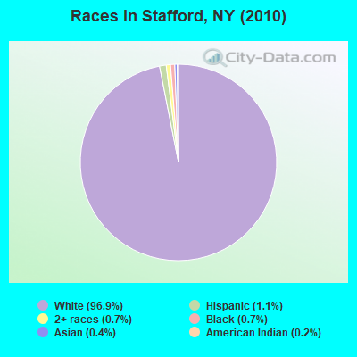
Races in Stafford detailed stats: ancestries, foreign born residents, place of birth
According to our research of New York and other state lists, there was 1 registered sex offender living in Stafford, New York as of May 10, 2024.
The ratio of all residents to sex offenders in Stafford is 2,459 to 1.
The ratio of registered sex offenders to all residents in this city is much lower than the state average.
 Recent articles from our blog. Our writers, many of them Ph.D. graduates or candidates, create easy-to-read articles on a wide variety of topics.

 | NY Pro Sports: Why so bad lately? (375 replies) |
| Functional vs. Beautiful City Design (138 replies) |
| What is Batavia like? (218 replies) |
| Any upstate NY cities with safe downtown neighborhoods? lots of activities? (27 replies) |
| Top Syracuse, NY area Tourist Attractions (10 replies) |
| buying a house in Saratoga county(Clifton park, Halfmoon, Ballston) -crumbling foundation issue? (2 replies) |
Latest news from Stafford, NY collected exclusively by city-data.com from local newspapers, TV, and radio stations
Ancestries: English (27.1%), German (26.8%), Irish (20.0%), Italian (16.4%), Polish (7.8%), French (4.6%).
Current Local Time: EST time zone
Elevation: 996 feet
Land area: 31.1 square miles.
Population density: 79 people per square mile (very low).
13 residents are foreign born
| This town: | 0.5% |
| New York: | 20.4% |
| Stafford town: | 2.3% ($1,987) |
| New York: | 1.9% ($2,847) |
Nearest city with pop. 50,000+: Rochester, NY  (26.7 miles , pop. 219,773).
Nearest city with pop. 1,000,000+: Philadelphia, PA (257.4 miles , pop. 1,517,550).
Nearest cities:
), ), ), Latitude: 43.00 N, Longitude: 78.09 W
Area code commonly used in this area: 585
Single-family new house construction building permits:
- 2022: 1 building, cost: $156,000
- 2021: 1 building, cost: $156,000
- 2020: 2 buildings, average cost: $248,200
- 2019: 2 buildings, average cost: $262,500
- 2018: 2 buildings, average cost: $262,500
- 2017: 3 buildings, average cost: $200,000
- 2016: 5 buildings, average cost: $196,000
- 2015: 2 buildings, average cost: $170,500
- 2013: 1 building, cost: $135,000
- 2012: 1 building, cost: $182,000
- 2009: 3 buildings, average cost: $215,000
- 2008: 2 buildings, average cost: $147,500
- 2007: 4 buildings, average cost: $147,500
- 2006: 6 buildings, average cost: $147,500
- 2005: 7 buildings, average cost: $147,500
- 2004: 8 buildings, average cost: $147,500
- 2003: 7 buildings, average cost: $147,500
- 2002: 6 buildings, average cost: $147,500
- 2001: 5 buildings, average cost: $126,000
- 2000: 5 buildings, average cost: $126,000
- 1999: 6 buildings, average cost: $146,700
- 1998: 4 buildings, average cost: $107,500
- 1997: 4 buildings, average cost: $107,500
| Here: | 3.9% |
| New York: | 4.4% |
- Educational services (13.7%)
- Construction (6.6%)
- Health care (6.5%)
- Accommodation & food services (5.4%)
- Public administration (4.3%)
- Agriculture, forestry, fishing & hunting (4.2%)
- Machinery (4.0%)
- Construction (11.3%)
- Agriculture, forestry, fishing & hunting (7.3%)
- Educational services (5.8%)
- Machinery (5.5%)
- Public administration (5.5%)
- Metal & metal products (5.5%)
- Truck transportation (4.0%)
- Educational services (23.4%)
- Health care (13.1%)
- Accommodation & food services (8.2%)
- Administrative & support & waste management services (6.6%)
- Personal & laundry services (5.3%)
- Miscellaneous manufacturing (3.8%)
- Professional, scientific, technical services (3.8%)
- Secretaries and administrative assistants (5.2%)
- Preschool, kindergarten, elementary, and middle school teachers (5.2%)
- Other production occupations, including supervisors (4.6%)
- Metal workers and plastic workers (3.8%)
- Sales representatives, services, wholesale and manufacturing (3.7%)
- Material recording, scheduling, dispatching, and distributing workers (3.4%)
- Other management occupations, except farmers and farm managers (3.3%)
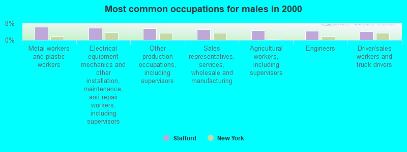
- Metal workers and plastic workers (6.2%)
- Electrical equipment mechanics and other installation, maintenance, and repair workers, including supervisors (5.8%)
- Other production occupations, including supervisors (5.6%)
- Sales representatives, services, wholesale and manufacturing (5.0%)
- Agricultural workers, including supervisors (4.6%)
- Engineers (4.4%)
- Driver/sales workers and truck drivers (4.1%)
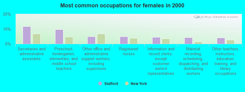
- Secretaries and administrative assistants (11.7%)
- Preschool, kindergarten, elementary, and middle school teachers (9.7%)
- Other office and administrative support workers, including supervisors (4.9%)
- Registered nurses (4.9%)
- Information and record clerks, except customer service representatives (4.6%)
- Material recording, scheduling, dispatching, and distributing workers (4.4%)
- Other teachers, instructors, education, training, and library occupations (4.2%)
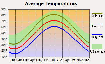
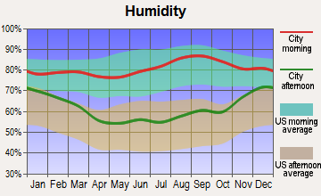
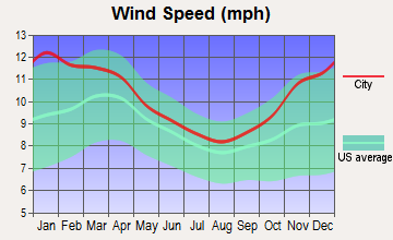
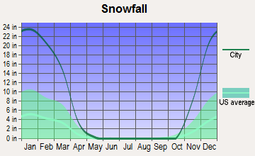
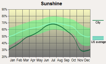
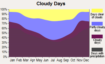
Average climate in Stafford, New York
Based on data reported by over 4,000 weather stations
Tornado activity:
Stafford-area historical tornado activity is below New York state average. It is 78% smaller than the overall U.S. average.
On 8/19/1970, a category F3 (max. wind speeds 158-206 mph) tornado 43.5 miles away from the Stafford town center injured 3 people and caused between $50,000 and $500,000 in damages.
On 5/2/1972, a category F2 (max. wind speeds 113-157 mph) tornado 17.9 miles away from the town center caused between $50,000 and $500,000 in damages.
Earthquake activity:
Stafford-area historical earthquake activity is significantly above New York state average. It is 68% smaller than the overall U.S. average.On 9/25/1998 at 19:52:52, a magnitude 5.2 (4.8 MB, 4.3 MS, 5.2 LG, 4.5 MW, Depth: 3.1 mi, Class: Moderate, Intensity: VI - VII) earthquake occurred 157.5 miles away from Stafford center
On 10/7/1983 at 10:18:46, a magnitude 5.3 (5.1 MB, 5.3 LG, 5.1 ML) earthquake occurred 199.3 miles away from Stafford center
On 4/20/2002 at 10:50:47, a magnitude 5.3 (5.3 ML, Depth: 3.0 mi) earthquake occurred 243.1 miles away from the city center
On 1/31/1986 at 16:46:43, a magnitude 5.0 (5.0 MB) earthquake occurred 184.4 miles away from the city center
On 8/23/2011 at 17:51:04, a magnitude 5.8 (5.8 MW, Depth: 3.7 mi) earthquake occurred 351.9 miles away from Stafford center
On 4/20/2002 at 10:50:47, a magnitude 5.2 (5.2 MB, 4.2 MS, 5.2 MW, 5.0 MW) earthquake occurred 241.4 miles away from Stafford center
Magnitude types: regional Lg-wave magnitude (LG), body-wave magnitude (MB), local magnitude (ML), surface-wave magnitude (MS), moment magnitude (MW)
Natural disasters:
The number of natural disasters in Genesee County (18) is near the US average (15).Major Disasters (Presidential) Declared: 9
Emergencies Declared: 9
Causes of natural disasters: Floods: 5, Snowstorms: 5, Storms: 4, Winter Storms: 4, Hurricanes: 2, Blizzard: 1, Ice Storm: 1, Power Outage: 1, Wind: 1, Other: 2 (Note: some incidents may be assigned to more than one category).
Hospitals and medical centers near Stafford:
- LAKE PLAINS DIALYSIS AT BATAVIA (Dialysis Facility, about 4 miles away; BATAVIA, NY)
- GENESEE CO DBA HOSPICE FAMILY (Hospital, about 5 miles away; BATAVIA, NY)
- GENESEE COUNTY NURSING HOME (Nursing Home, about 5 miles away; BATAVIA, NY)
- UNITED MEMORIAL MEDICAL CENTER Acute Care Hospitals (about 5 miles away; BATAVIA, NY)
- ST LUKE MANOR OF BATAVIA (Nursing Home, about 5 miles away; BATAVIA, NY)
- ST JEROME HOSPITAL (Hospital, about 5 miles away; BATAVIA, NY)
- BATAVIA NURSING HOME L L C (Nursing Home, about 5 miles away; BATAVIA, NY)
Airports located in Stafford:
- Stafford Airport (20NY) (Runways: 1)
Colleges/universities with over 2000 students nearest to Stafford:
- Genesee Community College (about 3 miles; Batavia, NY; Full-time enrollment: 4,290)
- SUNY College at Brockport (about 17 miles; Brockport, NY; FT enrollment: 7,398)
- SUNY College at Geneseo (about 20 miles; Geneseo, NY; FT enrollment: 5,520)
- Rochester Institute of Technology (about 22 miles; Rochester, NY; FT enrollment: 14,177)
- University of Rochester (about 25 miles; Rochester, NY; FT enrollment: 10,201)
- Monroe Community College (about 26 miles; Rochester, NY; FT enrollment: 14,295)
- Nazareth College (about 30 miles; Rochester, NY; FT enrollment: 2,632)
Points of interest:
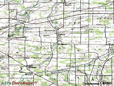
Notable locations in Stafford: Bel-Air Ranch Health Camp (A), Stafford Station (B), Schafer Potato Farms (C), Sweetland Pines Golf Course (D), Stafford Country Club (E), Roanoke Apple Farms (F). Display/hide their locations on the map
Churches in Stafford include: Saint Pauls Episcopal Church (A), Morganville United Church of Christ (B). Display/hide their locations on the map
Cemeteries: Fargo Road Pioneer Cemetery (1), Randall Cemetery (2), Stafford Cemetery (3), Morganville Cemetery (4), Walkers Cemetery (5). Display/hide their locations on the map
Lakes and reservoirs: Seven Springs Pond (A), Chapin Pond (B), Godfrey Pond (C), Horseshoe Lake (D). Display/hide their locations on the map
Creek: White Creek (A). Display/hide its location on the map
Park in Stafford: Stafford Village Four Corners Historic District (1). Display/hide its location on the map
Birthplace of: Archie D. Sanders - Politician, Jason DiSalvo - Grand Prix motorcycle racer.
| This town: | 2.4 people |
| New York: | 2.6 people |
| This town: | 71.0% |
| Whole state: | 63.5% |
| This town: | 7.8% |
| Whole state: | 6.8% |
Likely homosexual households (counted as self-reported same-sex unmarried-partner households)
- Lesbian couples: 0.7% of all households
- Gay men: 0.4% of all households
| This town: | 3.7% |
| Whole state: | 14.6% |
| This town: | 0.9% |
| Whole state: | 7.4% |
For population 15 years and over in Stafford:
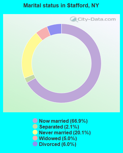
- Never married: 20.1%
- Now married: 66.9%
- Separated: 2.1%
- Widowed: 5.0%
- Divorced: 6.0%
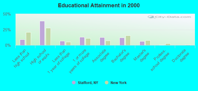
For population 25 years and over in Stafford:
- High school or higher: 90.9%
- Bachelor's degree or higher: 19.3%
- Graduate or professional degree: 7.3%
- Unemployed: 2.5%
- Mean travel time to work (commute): 21.2 minutes
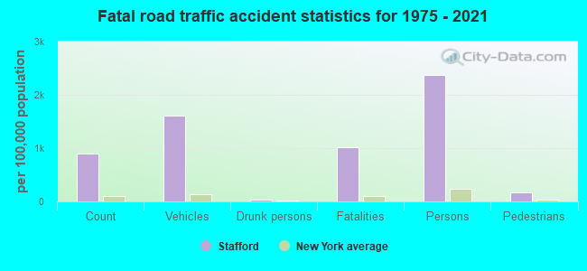
| Here: | 8.8 |
| New York average: | 14.2 |
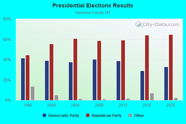
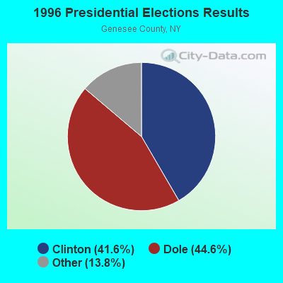
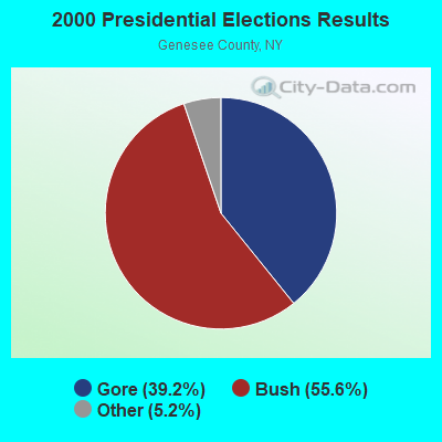
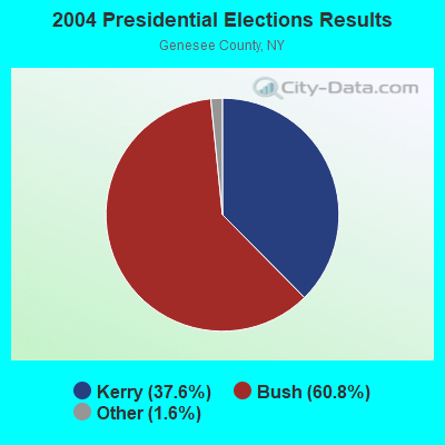
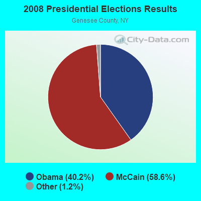
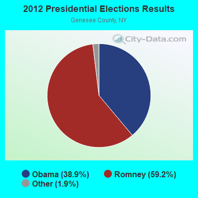
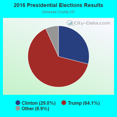
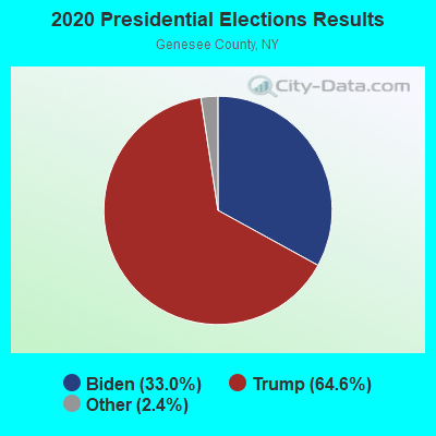
Graphs represent county-level data. Detailed 2008 Election Results
Religion statistics for Stafford, NY (based on Genesee County data)
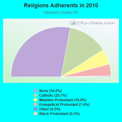
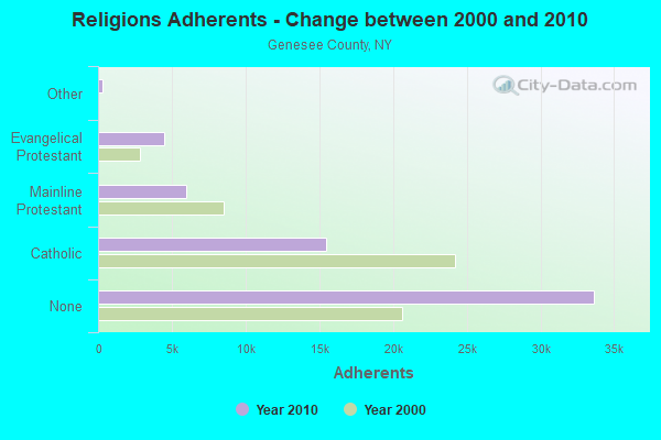
| Religion | Adherents | Congregations |
|---|---|---|
| Catholic | 15,455 | 9 |
| Mainline Protestant | 6,000 | 37 |
| Evangelical Protestant | 4,468 | 27 |
| Other | 321 | 3 |
| Black Protestant | 179 | 1 |
| None | 33,656 | - |
Food Environment Statistics:
| This county: | 1.72 / 10,000 pop. |
| State: | 4.13 / 10,000 pop. |
| This county: | 0.17 / 10,000 pop. |
| State: | 0.06 / 10,000 pop. |
| Genesee County: | 0.52 / 10,000 pop. |
| New York: | 0.92 / 10,000 pop. |
| This county: | 4.64 / 10,000 pop. |
| New York: | 1.68 / 10,000 pop. |
| Here: | 8.26 / 10,000 pop. |
| New York: | 8.82 / 10,000 pop. |
| Genesee County: | 8.6% |
| New York: | 8.2% |
| Here: | 27.3% |
| New York: | 23.8% |
| Genesee County: | 16.2% |
| New York: | 15.6% |
Strongest AM radio stations in Stafford:
- WHAM (1180 AM; 50 kW; ROCHESTER, NY; Owner: CITICASTERS LICENSES, L.P.)
- WBTA (1490 AM; 1 kW; BATAVIA, NY; Owner: BRO-BEN COMMUNICATIONS, INC.)
- WWKB (1520 AM; 50 kW; BUFFALO, NY; Owner: ENTERCOM BUFFALO LICENSE, LLC)
- WLGZ (990 AM; 5 kW; ROCHESTER, NY; Owner: KIMTRON, INC.)
- WCJW (1140 AM; daytime; 2 kW; WARSAW, NY; Owner: LLOYD LANE, INCORPORATED)
- WHTK (1280 AM; 5 kW; ROCHESTER, NY)
- WTOR (770 AM; daytime; 9 kW; YOUNGSTOWN, NY; Owner: BIRACH BROADCASTING CORPORATION)
- WYSL (1040 AM; 2 kW; AVON, NY; Owner: RADIO LIVINGSTON, LTD)
- WXXI (1370 AM; 5 kW; ROCHESTER, NY; Owner: WXXI PUBLIC BROADCASTING COUNCIL)
- WGR (550 AM; 5 kW; BUFFALO, NY; Owner: ENTERCOM BUFFALO LICENSE, LLC)
- WXRL (1300 AM; 5 kW; LANCASTER, NY; Owner: DOME BROADCASTING, INC.)
- WHIC (1460 AM; 5 kW; ROCHESTER, NY; Owner: HOLY FAMILY COMMUNICATIONS)
- WBEN (930 AM; 5 kW; BUFFALO, NY; Owner: ENTERCOM BUFFALO LICENSE, LLC)
Strongest FM radio stations in Stafford:
- WGCC-FM (90.7 FM; BATAVIA, NY; Owner: GENESEE COMMUNITY COLLEGE)
- DW208AM (89.5 FM; BATAVIA, NY; Owner: AMERICAN FAMILY ASSOCIATION)
- WCOU (88.3 FM; WARSAW, NY; Owner: FAMILY LIFE MINISTRIES, INC.)
- WMJQ (105.5 FM; BROCKPORT, NY; Owner: CANANDAIGUA BROADCASTING, INC.)
- WTSS (102.5 FM; BUFFALO, NY; Owner: ENTERCOM BUFFALO LICENSE, LLC)
- WLOF (101.7 FM; ATTICA, NY; Owner: HOLY FAMILY COMMUNICATIONS, INC.)
- WNSA (107.7 FM; WETHERSFIELD TWNSHP, NY; Owner: ADELPHIA COMMUNICATIONS CORPORATION, DEBTOR-IN-POSSESSION)
- WRMM-FM (101.3 FM; ROCHESTER, NY; Owner: INFINITY RADIO OPERATIONS INC.)
- WCIY (88.9 FM; CANANDAIGUA, NY; Owner: FAMILY LIFE MINISTRIES, INC.)
- WBZA (98.9 FM; ROCHESTER, NY; Owner: ENTERCOM ROCHESTER LICENSE, LLC.)
- WFXF (107.3 FM; SOUTH BRISTOL TOWNSH, NY; Owner: CITICASTERS LICENSES, L.P.)
- WNVE (95.1 FM; HONEOYE FALLS, NY; Owner: CITICASTERS LICENSES, L.P.)
- WDKX (103.9 FM; ROCHESTER, NY; Owner: MONROE COUNTY BROADCASTING CO., LTD.)
- WJCA (102.1 FM; ALBION, NY; Owner: CSN INTERNATIONAL)
- WDCZ-FM (102.7 FM; WEBSTER, NY; Owner: KIMTRON, INC.)
- WGRF (96.9 FM; BUFFALO, NY; Owner: CITADEL BROADCASTING COMPANY)
- WISY (102.3 FM; CANANDAIGUA, NY; Owner: CITICASTERS LICENSES, L.P.)
- WCMF-FM (96.5 FM; ROCHESTER, NY; Owner: INFINITY RADIO OPERATIONS INC.)
- WXXI-FM (91.5 FM; ROCHESTER, NY; Owner: WXXI PUBLIC BROADCASTING COUNCIL)
- W238AB (95.5 FM; ROCHESTER, NY; Owner: CITICASTERS LICENSES, L.P.)
TV broadcast stations around Stafford:
- WPXJ-TV (Channel 51; BATAVIA, NY; Owner: PAXSON BUFFALO LICENSE, INC.)
- WNYO-TV (Channel 49; BUFFALO, NY; Owner: NEW YORK TELEVISION, INC.)
- WGRZ-TV (Channel 2; BUFFALO, NY; Owner: MULTIMEDIA ENTERTAINMENT, INC.)
- WKBW-TV (Channel 7; BUFFALO, NY; Owner: WKBW-TV LICENSE, INC.)
- WIVB-TV (Channel 4; BUFFALO, NY; Owner: WIVB BROADCASTING, LLC)
- WNED-TV (Channel 17; BUFFALO, NY; Owner: WESTERN NY PUBLIC BROADCASTING ASSOC.)
- WUTV (Channel 29; BUFFALO, NY; Owner: WUTV LICENSEE, LLC)
- WNLO (Channel 23; BUFFALO, NY; Owner: WIVB BROADCASTING, LLC)
- WBXO-LP (Channel 15; ROCHESTER, NY; Owner: METRO TV, INC.)
- National Bridge Inventory (NBI) Statistics
- 23Number of bridges
- 128ft / 39.1mTotal length
- $24,127,000Total costs
- 180,480Total average daily traffic
- 18,666Total average daily truck traffic
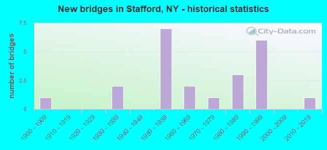
- New bridges - historical statistics
- 11900-1909
- 21930-1939
- 71950-1959
- 21960-1969
- 11970-1979
- 31980-1989
- 61990-1999
- 12010-2019
FCC Registered Cell Phone Towers:
1 (See the full list of FCC Registered Cell Phone Towers in Stafford)FCC Registered Antenna Towers:
33 (See the full list of FCC Registered Antenna Towers)FCC Registered Broadcast Land Mobile Towers:
4- Rt 5 1/2 Mi W (Lat: 42.982556 Lon: -78.093361), Call Sign: KXK484,
Assigned Frequencies: 31.0400 MHz, Grant Date: 06/23/2001, Expiration Date: 08/18/2011, Cancellation Date: 04/08/2002, Registrant: Blooston, Mordkofsky, Dickens, Duffy & Prendergast, 2120 L Street, N.W., Suite 300, Washington, DC 20037, Phone: (202) 659-0830
- 5908 Horseshoe Lake Rd (Lat: 43.006444 Lon: -78.091139), Call Sign: KNBJ698, Licensee ID: L00102260,
Assigned Frequencies: 154.490 MHz, Grant Date: 04/10/1996, Expiration Date: 04/11/2001, Cancellation Date: 06/17/2001, Registrant: Hy Hope Farms Inc, 5908 Horseshoe Lake Rd, Stafford, NY 14143, Phone: (716) 343-7973
- Lat: 42.987139 Lon: -78.071111, Call Sign: WQSB512,
Assigned Frequencies: 457.525 MHz, 457.550 MHz, 457.575 MHz, 457.600 MHz, Grant Date: 08/27/2013, Expiration Date: 08/27/2023, Cancellation Date: 10/28/2023, Certifier: Peter Cavanaugh, Registrant: Cara Enterprises Inc, Las Vegas, NV 89140-0124, Phone: (702) 838-9728, Fax: (702) 363-4607, Email:
- Lat: 42.987139 Lon: -78.071111, Call Sign: WSAG490,
Assigned Frequencies: 457.525 MHz, 457.550 MHz, 457.575 MHz, 457.600 MHz, Grant Date: 01/17/2024, Expiration Date: 01/17/2034, Certifier: Mike Armstrong, Registrant: Stafford Country Club, 8873 Morganville Rd, Stafford, NY 14143, Phone: (585) 343-9282, Email:
FCC Registered Microwave Towers:
2- Stafford (BU04102), Transit Rd (Lat: 42.957611 Lon: -78.069250), Type: Tower, Structure height: 67.1 m, Overall height: 70.4 m, Call Sign: WPSI891, Licensee ID: L00152704,
Assigned Frequencies: 10675.4 MHz, Grant Date: 04/26/2011, Expiration Date: 05/14/2021, Cancellation Date: 07/17/2021, Certifier: Cheri S O'Kane, Registrant: Sprint Spectrum L.P.
- Leroy, 8940 Buckley Road (Lat: 42.984000 Lon: -78.047444), Type: Tower, Structure height: 56.4 m, Overall height: 60.7 m, Call Sign: WQFL670,
Assigned Frequencies: 6226.89 MHz, 6197.24 MHz, 6256.54 MHz, 6286.19 MHz, Grant Date: 08/11/2006, Expiration Date: 08/11/2016, Cancellation Date: 02/25/2014, Certifier: Richard A Craig, Registrant: Verizon Wireless, 1120 Sanctuary Pkwy, #150 Gasa5reg, Alpharetta, GA 30009-7630, Phone: (770) 797-1070, Fax: (770) 797-1036, Email:
FCC Registered Amateur Radio Licenses:
12 (See the full list of FCC Registered Amateur Radio Licenses in Stafford)2002 - 2018 National Fire Incident Reporting System (NFIRS) incidents
- Fire incident types reported to NFIRS in Stafford, NY
- 6137.4%Structure Fires
- 5533.7%Outside Fires
- 2716.6%Other
- 2012.3%Mobile Property/Vehicle Fires
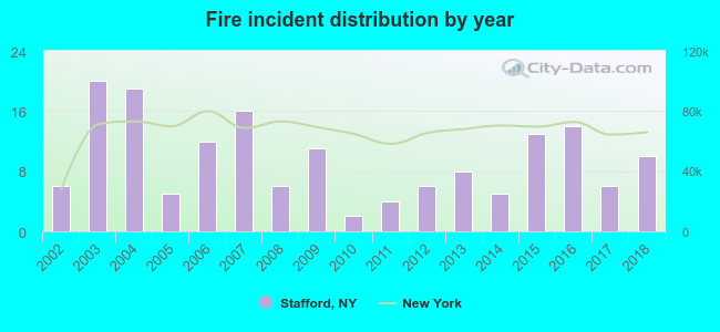 Based on the data from the years 2002 - 2018 the average number of fire incidents per year is 10. The highest number of reported fires - 20 took place in 2003, and the least - 2 in 2010. The data has a rising trend.
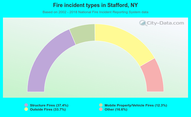 When looking into fire subcategories, the most reports belonged to: Structure Fires (37.4%), and Outside Fires (33.7%).
| Most common first names in Stafford, NY among deceased individuals | ||
| Name | Count | Lived (average) |
|---|---|---|
| John | 13 | 66.7 years |
| Richard | 9 | 63.0 years |
| William | 8 | 76.2 years |
| Edward | 8 | 75.9 years |
| Robert | 7 | 70.7 years |
| Mary | 7 | 75.1 years |
| George | 6 | 80.5 years |
| Charles | 6 | 66.2 years |
| Ruth | 6 | 83.5 years |
| Doris | 5 | 76.2 years |
| Most common last names in Stafford, NY among deceased individuals | ||
| Last name | Count | Lived (average) |
|---|---|---|
| Call | 9 | 81.1 years |
| Smith | 8 | 83.6 years |
| Cone | 7 | 63.3 years |
| Kalicki | 6 | 80.3 years |
| Woeller | 6 | 84.2 years |
| Legg | 5 | 78.2 years |
| Gillard | 4 | 78.9 years |
| Heywood | 4 | 83.0 years |
| Didget | 4 | 75.3 years |
| Rumsey | 4 | 82.5 years |
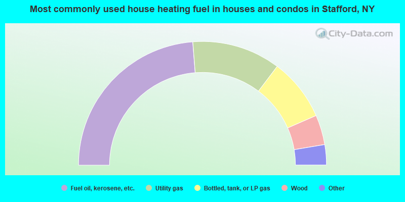
- 47.5%Fuel oil, kerosene, etc.
- 23.1%Utility gas
- 16.3%Bottled, tank, or LP gas
- 7.8%Wood
- 3.4%Electricity
- 1.5%Other fuel
- 0.4%Coal or coke
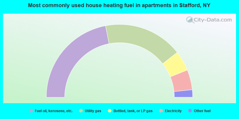
- 43.9%Fuel oil, kerosene, etc.
- 35.0%Utility gas
- 8.9%Bottled, tank, or LP gas
- 8.9%Electricity
- 3.3%Other fuel
Stafford compared to New York state average:
- Median house value significantly below state average.
- Unemployed percentage significantly below state average.
- Black race population percentage significantly below state average.
- Hispanic race population percentage significantly below state average.
- Median age above state average.
- Foreign-born population percentage significantly below state average.
- Renting percentage significantly below state average.
- Length of stay since moving in significantly above state average.
- Number of rooms per house significantly below state average.
- House age significantly below state average.

|
|
Total of 13 patent applications in 2008-2024.