St. Francis, Maine

St. Francis: Sunset looking West toward the St.John River from porch at St.Francis Maine home

St. Francis: Sunset looking West toward the St.John River from porch at St.Francis home
- add
your
Submit your own pictures of this town and show them to the world
- OSM Map
- General Map
- Google Map
- MSN Map
Population change since 2000: -15.9%
 |
| Males: 243 | |
| Females: 242 |
| Median resident age: | 51.3 years |
| Maine median age: | 43.0 years |
Zip codes: 04774.
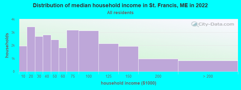
| St. Francis: | $44,779 |
| ME: | $69,543 |
Estimated per capita income in 2022: $27,853 (it was $13,496 in 2000)
St. Francis town income, earnings, and wages data
Estimated median house or condo value in 2022: $106,292 (it was $43,900 in 2000)
| St. Francis: | $106,292 |
| ME: | $290,600 |
Mean prices in 2022: all housing units: $179,108; detached houses: $185,023; townhouses or other attached units: $218,327; in 2-unit structures: $262,505; in 3-to-4-unit structures: $121,406; in 5-or-more-unit structures: $185,084; mobile homes: $117,009; occupied boats, rvs, vans, etc.: $12,682
Detailed information about poverty and poor residents in St. Francis, ME
Compare current foreclosures near your location:
| Photo | Address | Area | Beds / Baths | Price | Details |
|---|---|---|---|---|---|

|
#1
E 21st Ave
Columbus, OH 43211
|
1,061 sq. feet
|
1 baths 3 beds |
$179,900
|
show details |

|
#2
S High St
Columbus, OH 43207
|
1,678 sq. feet
|
2 baths 4 beds |
$31,900
|
show details |

|
#3
Bayberry Cir
Columbus, OH 43207
|
1,564 sq. feet
|
1 baths 3 beds |
$127,500
|
show details |

|
#4
Armada Rd
Columbus, OH 43232
|
1,028 sq. feet
|
1 baths 4 beds |
show details | |

|
#5
Grasmere Ave
Columbus, OH 43211
|
720 sq. feet
|
1 baths 2 beds |
show details | |

|
#6
Safford Ave
Columbus, OH 43223
|
784 sq. feet
|
1 baths 2 beds |
show details | |

|
#7
Scottwood Rd
Columbus, OH 43227
|
1,008 sq. feet
|
1 baths 3 beds |
show details | |

|
#8
Summertree Ln
Westerville, OH 43081
|
2,496 sq. feet
|
2 baths 3 beds |
show details | |

|
#9
Derrer Rd -872
Columbus, OH 43204
|
1,667 sq. feet
|
2 baths 5 beds |
show details | |

|
#10
Wrexham Ave
Columbus, OH 43223
|
1,235 sq. feet
|
1 baths 3 beds |
show details |
| Photo | Address | Area | Beds / Baths | Price | Details |
|---|---|---|---|---|---|

|
#11
Lehner Rd
Columbus, OH 43224
|
1,628 sq. feet
|
2 baths 4 beds |
show details | |

|
#12
Fahlander Dr N
Columbus, OH 43229
|
1,338 sq. feet
|
2 baths 3 beds |
show details | |

|
#13
High Free Pike
West Jefferson, OH 43162
|
1,216 sq. feet
|
2 baths 4 beds |
show details | |

|
#14
S Richardson Ave
Columbus, OH 43204
|
1,520 sq. feet
|
2 baths 3 beds |
show details | |

|
#15
Brookstone Dr
Westerville, OH 43082
|
1,783 sq. feet
|
3 baths 3 beds |
show details | |

|
#16
E Howard Rd
Columbus, OH 43207
|
1,056 sq. feet
|
1 baths 3 beds |
show details | |

|
#17
Midland Ave
Columbus, OH 43223
|
1,518 sq. feet
|
1 baths 2 beds |
show details | |

|
#18
Marshrun Dr
Grove City, OH 43123
|
2,036 sq. feet
|
2 baths 4 beds |
show details | |

|
#19
N Roys Ave
Columbus, OH 43204
|
1,248 sq. feet
|
2 baths 3 beds |
show details | |

|
#20
Meadowbrook Dr
Columbus, OH 43207
|
1,752 sq. feet
|
2 baths 4 beds |
show details |
| Photo | Address | Area | Beds / Baths | Price | Details |
|---|---|---|---|---|---|

|
#21
Stoneybrook Blvd # 21a
Hilliard, OH 43026
|
1,231 sq. feet
|
2 baths 3 beds |
show details | |

|
#22
Mink St SW
Pataskala, OH 43062
|
1,442 sq. feet
|
1 baths 3 beds |
show details | |

|
#23
London Groveport Rd
Grove City, OH 43123
|
816 sq. feet
|
1 baths 2 beds |
show details | |

|
#24
Glenmate Ct
Columbus, OH 43223
|
1,050 sq. feet
|
1 baths 3 beds |
show details | |

|
#25
Gladys Rd
Columbus, OH 43228
|
832 sq. feet
|
1 baths 3 beds |
show details | |

|
#26
Striebel Ct
Columbus, OH 43227
|
925 sq. feet
|
1 baths 3 beds |
show details | |

|
#27
N 18th St
Columbus, OH 43203
|
1,690 sq. feet
|
1 baths 4 beds |
show details | |

|
#28
Fergus Rd
Grove City, OH 43123
|
3,312 sq. feet
|
2 baths 4 beds |
show details | |

|
#29
Chester Rd
Columbus, OH 43221
|
3,300 sq. feet
|
4 baths 5 beds |
show details | |

|
#30
Sleeping Meadow Dr
New Albany, OH 43054
|
3,211 sq. feet
|
2 baths 4 beds |
show details |
| Photo | Address | Area | Beds / Baths | Price | Details |
|---|---|---|---|---|---|

|
#31
E Welch Ave
Columbus, OH 43207
|
1,864 sq. feet
|
2 baths 4 beds |
show details | |

|
#32
Kingsglen Dr
Grove City, OH 43123
|
1,635 sq. feet
|
2 baths 4 beds |
show details | |

|
#33
S Hague Ave
Columbus, OH 43204
|
979 sq. feet
|
1 baths 2 beds |
show details | |

|
#34
Ashgrove Dr
Grove City, OH 43123
|
1,772 sq. feet
|
2 baths 4 beds |
show details | |

|
#35
Chidley St
Galloway, OH 43119
|
1,502 sq. feet
|
1 baths 3 beds |
show details | |

|
#36
Hildreth Ave
Columbus, OH 43203
|
1,798 sq. feet
|
2 baths 4 beds |
show details | |

|
#37
Fairfield Ave
Columbus, OH 43203
|
984 sq. feet
|
1 baths 2 beds |
show details | |

|
#38
Ratify Blvd
Columbus, OH 43207
|
1,356 sq. feet
|
2 baths 3 beds |
show details | |

|
#39
Andrus Ave
Columbus, OH 43227
|
1,264 sq. feet
|
1 baths 3 beds |
show details | |

|
#40
Berrywood Dr
Columbus, OH 43220
|
1,182 sq. feet
|
1 baths 2 beds |
show details |
| Photo | Address | Area | Beds / Baths | Price | Details |
|---|---|---|---|---|---|

|
#41
Simpson Dr
Columbus, OH 43227
|
1,104 sq. feet
|
1 baths 3 beds |
show details | |

|
#42
Nantucket Ave
Columbus, OH 43235
|
1,864 sq. feet
|
2 baths 3 beds |
show details | |

|
#43
Bostwick Rd
Columbus, OH 43227
|
1,284 sq. feet
|
1 baths 4 beds |
show details | |

|
#44
Messner Dr
Hilliard, OH 43026
|
832 sq. feet
|
1 baths 2 beds |
show details | |

|
#45
Camhurst Ct
Galloway, OH 43119
|
1,969 sq. feet
|
2 baths 3 beds |
show details | |

|
#46
Illinois Ave
Westerville, OH 43081
|
1,120 sq. feet
|
1 baths 3 beds |
show details | |

|
#47
Renford Ct
Powell, OH 43065
|
1,795 sq. feet
|
1 baths 3 beds |
show details | |

|
#48
Casa Blvd
Grove City, OH 43123
|
1,002 sq. feet
|
1 baths 2 beds |
show details | |

|
#49
Mango Ln
Hilliard, OH 43026
|
1,024 sq. feet
|
1 baths 2 beds |
show details | |

|
Check over 1 million property listings on Foreclosure.com!
|
browse all offers | |||

- 46796.3%White alone
- 91.9%American Indian alone
- 61.2%Two or more races
- 30.6%Hispanic
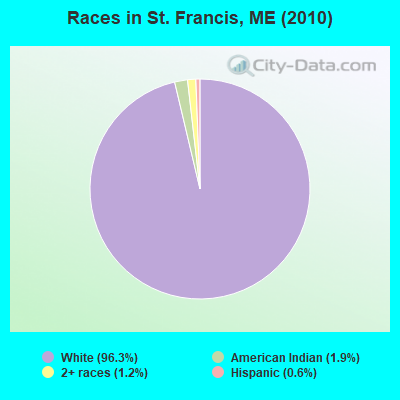
Races in St. Francis detailed stats: ancestries, foreign born residents, place of birth
According to our research of Maine and other state lists, there was 1 registered sex offender living in St. Francis, Maine as of May 09, 2024.
The ratio of all residents to sex offenders in St. Francis is 485 to 1.
The ratio of registered sex offenders to all residents in this city is near the state average.
 Recent articles from our blog. Our writers, many of them Ph.D. graduates or candidates, create easy-to-read articles on a wide variety of topics.

 | Maine Covid 19 Thread (376 replies) |
| Maine Demographics (36 replies) |
| Maine weather thread (3207 replies) |
| Francais dans le Maine (3 replies) |
| Looking for Fort Kent and surrounding area info (24 replies) |
| WAGM Morning News (10 replies) |
Latest news from St. Francis, ME collected exclusively by city-data.com from local newspapers, TV, and radio stations
Ancestries: United States (46.3%), French (33.4%), Irish (11.4%), French Canadian (6.4%), English (4.3%), Italian (1.0%).
Current Local Time: EST time zone
Incorporated on 03/01/1967
Elevation: 597 feet
Land area: 29.8 square miles.
Population density: 16 people per square mile (very low).
14 residents are foreign born (2.4% North America).
| This town: | 2.4% |
| Maine: | 2.9% |
| St. Francis town: | 0.8% ($368) |
| Maine: | 1.5% ($1,417) |
Nearest city with pop. 50,000+: Portland, ME  (251.3 miles , pop. 64,249).
Nearest city with pop. 200,000+: Boston, MA (352.1 miles , pop. 589,141).
Nearest city with pop. 1,000,000+: Bronx, NY (502.5 miles , pop. 1,332,650).
Nearest cities:
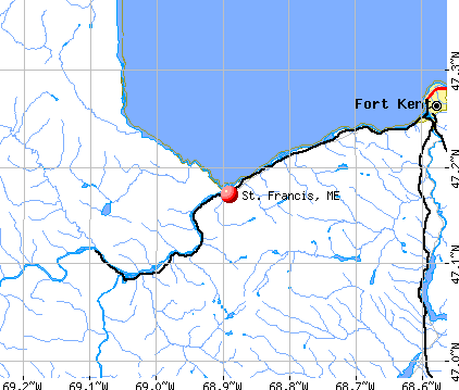
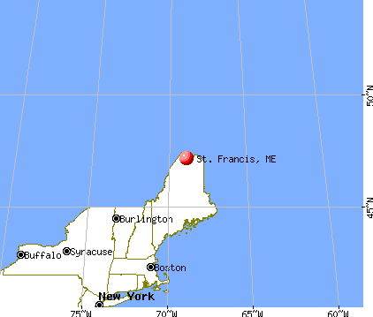
), ), ), ), Latitude: 47.16 N, Longitude: 68.87 W
Area code commonly used in this area: 207
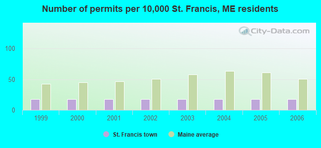
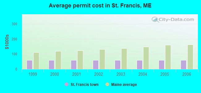
Single-family new house construction building permits:
- 2006: 1 building, cost: $60,000
- 2005: 1 building, cost: $60,000
- 2004: 1 building, cost: $60,000
- 2003: 1 building, cost: $60,000
- 2002: 1 building, cost: $60,000
- 2001: 1 building, cost: $60,000
- 2000: 1 building, cost: $60,000
- 1999: 1 building, cost: $60,000
| Here: | 7.2% |
| Maine: | 3.4% |

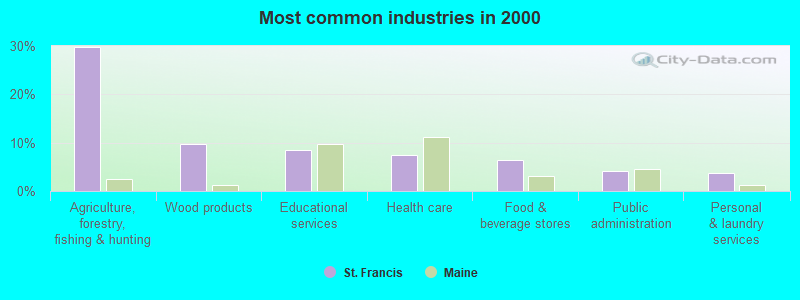
- Agriculture, forestry, fishing & hunting (29.9%)
- Wood products (9.7%)
- Educational services (8.6%)
- Health care (7.5%)
- Food & beverage stores (6.3%)
- Public administration (4.1%)
- Personal & laundry services (3.7%)
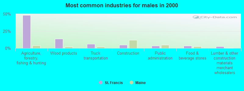
- Agriculture, forestry, fishing & hunting (48.3%)
- Wood products (13.6%)
- Truck transportation (6.1%)
- Construction (4.8%)
- Public administration (3.4%)
- Food & beverage stores (3.4%)
- Lumber & other construction materials merchant wholesalers (2.7%)
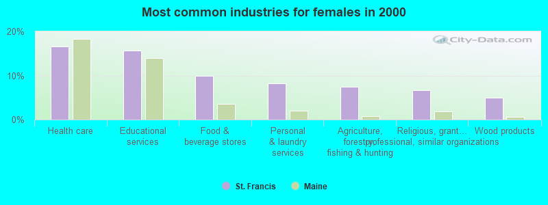
- Health care (16.5%)
- Educational services (15.7%)
- Food & beverage stores (9.9%)
- Personal & laundry services (8.3%)
- Agriculture, forestry, fishing & hunting (7.4%)
- Religious, grantmaking, civic, professional, similar organizations (6.6%)
- Wood products (5.0%)

- Laborers and material movers, hand (9.0%)
- Fishing, hunting, and forestry occupations (8.6%)
- Agricultural workers, including supervisors (5.6%)
- Nursing, psychiatric, and home health aides (4.5%)
- Secretaries and administrative assistants (4.1%)
- Bookkeeping, accounting, and auditing clerks (4.1%)
- Other production occupations, including supervisors (4.1%)

- Fishing, hunting, and forestry occupations (15.6%)
- Agricultural workers, including supervisors (10.2%)
- Laborers and material movers, hand (10.2%)
- Other production occupations, including supervisors (7.5%)
- Driver/sales workers and truck drivers (6.1%)
- Woodworkers (4.1%)
- Carpenters (4.1%)

- Nursing, psychiatric, and home health aides (9.9%)
- Secretaries and administrative assistants (9.1%)
- Personal appearance workers (8.3%)
- Cooks and food preparation workers (8.3%)
- Bookkeeping, accounting, and auditing clerks (7.4%)
- Laborers and material movers, hand (7.4%)
- Cashiers (6.6%)
Average climate in St. Francis, Maine
Based on data reported by over 4,000 weather stations


Earthquake activity:
St. Francis-area historical earthquake activity is above Maine state average. It is 87% smaller than the overall U.S. average.On 4/20/2002 at 10:50:47, a magnitude 5.3 (5.3 ML, Depth: 3.0 mi, Class: Moderate, Intensity: VI - VII) earthquake occurred 296.0 miles away from the city center
On 7/14/2006 at 09:34:48, a magnitude 3.9 (3.9 MD, Depth: 8.6 mi, Class: Light, Intensity: II - III) earthquake occurred 21.8 miles away from the city center
On 4/20/2002 at 10:50:47, a magnitude 5.2 (5.2 MB, 4.2 MS, 5.2 MW, 5.0 MW) earthquake occurred 297.9 miles away from the city center
On 10/7/1983 at 10:18:46, a magnitude 5.3 (5.1 MB, 5.3 LG, 5.1 ML) earthquake occurred 345.5 miles away from the city center
On 10/16/2012 at 23:12:25, a magnitude 4.7 (4.7 ML, Depth: 10.0 mi, Class: Light, Intensity: IV - V) earthquake occurred 261.4 miles away from the city center
On 1/19/1982 at 00:14:42, a magnitude 4.7 (4.5 MB, 4.7 MD, 4.5 LG) earthquake occurred 286.0 miles away from St. Francis center
Magnitude types: regional Lg-wave magnitude (LG), body-wave magnitude (MB), duration magnitude (MD), local magnitude (ML), surface-wave magnitude (MS), moment magnitude (MW)
Natural disasters:
The number of natural disasters in Aroostook County (22) is greater than the US average (15).Major Disasters (Presidential) Declared: 13
Emergencies Declared: 9
Causes of natural disasters: Floods: 10, Storms: 8, Snows: 7, Heavy Rains: 2, Blizzard: 1, Hurricane: 1, Ice Storm: 1, Snowfall: 1, Snowstorm: 1, Wind: 1, Winter Storm: 1, Other: 2 (Note: some incidents may be assigned to more than one category).

Colleges/universities with over 2000 students nearest to St. Francis:
- University of Maine (about 158 miles; Orono, ME; Full-time enrollment: 8,931)
- Husson University (about 162 miles; Bangor, ME; FT enrollment: 2,421)
- University of Maine at Farmington (about 184 miles; Farmington, ME; FT enrollment: 2,036)
- University of Maine at Augusta (about 201 miles; Augusta, ME; FT enrollment: 3,204)
- Saint Joseph's College of Maine (about 244 miles; Standish, ME; FT enrollment: 2,010)
- University of Southern Maine (about 252 miles; Portland, ME; FT enrollment: 6,647)
- Southern Maine Community College (about 252 miles; South Portland, ME; FT enrollment: 4,666)
Public elementary/middle school in St. Francis:
- ST FRANCIS ELEMENTARY SCHOOL (Location: 857 MAIN ST 99, Grades: PK-5)
Points of interest:
Notable location: Saint Frances Fire Department (A). Display/hide its location on the map
Church in St. Francis: Saint Francis Catholic Church (A). Display/hide its location on the map
Cemeteries: Old Saint Charles Cemetery (1), Saint Charles Cemetery (2), Saint Pauls Congregational Cemetery (3). Display/hide their locations on the map
Lakes: Bran Lake (A), McLean Lake (B). Display/hide their locations on the map
Streams, rivers, and creeks: Thibideau Brook (A), McLean Brook (B), Wiggins Brook (C), Petite Brook (D). Display/hide their locations on the map
| This town: | 2.1 people |
| Maine: | 2.3 people |
| This town: | 61.1% |
| Whole state: | 62.9% |
| This town: | 5.6% |
| Whole state: | 9.4% |
No gay or lesbian households reported
| This town: | 7.7% |
| Whole state: | 10.9% |
| This town: | 3.3% |
| Whole state: | 4.1% |
For population 15 years and over in St. Francis:
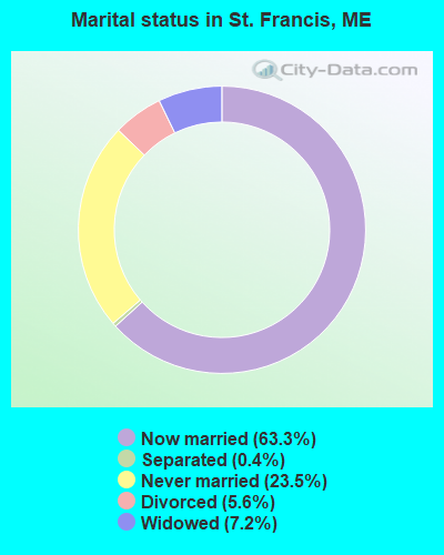
- Never married: 23.5%
- Now married: 63.3%
- Separated: 0.4%
- Widowed: 7.2%
- Divorced: 5.6%
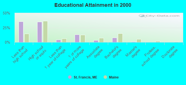
For population 25 years and over in St. Francis:
- High school or higher: 64.7%
- Bachelor's degree or higher: 9.1%
- Graduate or professional degree: 1.2%
- Unemployed: 10.4%
- Mean travel time to work (commute): 39.1 minutes
| Here: | 14.9 |
| Maine average: | 11.2 |


Graphs represent county-level data. Detailed 2008 Election Results
Religion statistics for St. Francis, ME (based on Aroostook County data)


| Religion | Adherents | Congregations |
|---|---|---|
| Catholic | 22,200 | 27 |
| Mainline Protestant | 5,845 | 40 |
| Evangelical Protestant | 4,411 | 51 |
| Other | 957 | 7 |
| Orthodox | 10 | 1 |
| None | 38,447 | - |
Food Environment Statistics:
| This county: | 4.03 / 10,000 pop. |
| Maine: | 2.80 / 10,000 pop. |
| Aroostook County: | 0.14 / 10,000 pop. |
| Maine: | 0.14 / 10,000 pop. |
| Aroostook County: | 2.22 / 10,000 pop. |
| Maine: | 2.20 / 10,000 pop. |
| Aroostook County: | 7.78 / 10,000 pop. |
| Maine: | 5.75 / 10,000 pop. |
| Aroostook County: | 9.17 / 10,000 pop. |
| State: | 11.02 / 10,000 pop. |
| This county: | 11.7% |
| Maine: | 8.2% |
| This county: | 27.6% |
| Maine: | 25.0% |
Strongest AM radio stations in St. Francis:
- WFST (600 AM; 5 kW; CARIBOU, ME; Owner: NORTHERN BROADCAST MINISTRIES, INC.)
- WEGP (1390 AM; 5 kW; PRESQUE ISLE, ME; Owner: DECELLES/SMITH MEDIA, INC.)
- WREM (710 AM; daytime; 5 kW; MONTICELLO, ME; Owner: ALLAN H WEINER)
- WCHP (760 AM; 35 kW; CHAMPLAIN, NY; Owner: CHAMPLAIN RADIO, INC.)
- WRKO (680 AM; 50 kW; BOSTON, MA; Owner: ENTERCOM BOSTON LICENSE, LLC)
- WNNZ (640 AM; 50 kW; WESTFIELD, MA; Owner: CLEAR CHANNEL BROADCASTING LICENSES, INC.)
- WEEI (850 AM; 50 kW; BOSTON, MA; Owner: ENTERCOM BOSTON LICENSE, LLC)
- WCRN (830 AM; 50 kW; WORCESTER, MA; Owner: CARTER BROADCASTING CORPORATION)
- WBZ (1030 AM; 50 kW; BOSTON, MA; Owner: INFINITY BROADCASTING OPERATIONS, INC.)
- WGY (810 AM; 50 kW; SCHENECTADY, NY; Owner: CLEAR CHANNEL BROADCASTING LICENSES, INC.)
- WICY (1490 AM; 50 kW; MALONE, NY; Owner: CARTIER COMMUNICATIONS INC.)
- WALE (990 AM; 50 kW; GREENVILLE, RI; Owner: NORTH AMERICAN BROADCASTING CO., INC.)
- WKOX (1200 AM; 50 kW; FRAMINGHAM, MA; Owner: CAPSTAR TX LIMITED PARTNERSHIP)
Strongest FM radio stations in St. Francis:
- WBPW (96.9 FM; PRESQUE ISLE, ME; Owner: CITADEL BROADCASTING COMPANY)
- WMEF (106.5 FM; FORT KENT, ME; Owner: MAINE PUBLIC BROADCASTING CORP)
- WCXX (102.3 FM; MADAWASKA, ME; Owner: THE CANXUS BROADCASTING CORPORATION)
TV broadcast stations around St. Francis:
- W02AU (Channel 2; ST. FRANCIS, ME; Owner: ST. FRANCIS CHAMBER OF COMMERCE)
- W04AY (Channel 4; ST. FRANCIS, ME; Owner: MAINE PUBLIC BROADCASTING CORP.)
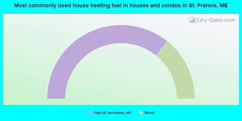
- 71.8%Fuel oil, kerosene, etc.
- 28.2%Wood
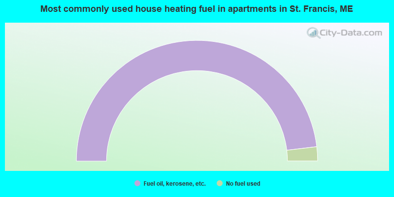
- 96.2%Fuel oil, kerosene, etc.
- 3.8%No fuel used
St. Francis compared to Maine state average:
- Median household income below state average.
- Median house value significantly below state average.
- Black race population percentage significantly below state average.
- Hispanic race population percentage significantly below state average.
- Median age significantly above state average.
- Foreign-born population percentage below state average.
- Length of stay since moving in significantly above state average.
- Number of rooms per house significantly below state average.
- House age significantly below state average.
- Percentage of population with a bachelor's degree or higher significantly below state average.