Spring Prairie, Wisconsin
Submit your own pictures of this town and show them to the world
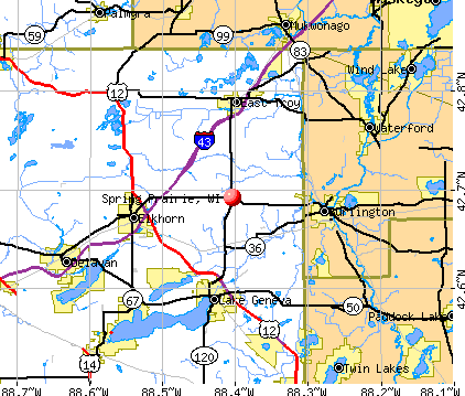
- OSM Map
- General Map
- Google Map
- MSN Map
Population change since 2000: +4.4%
 |
| Males: 1,125 | |
| Females: 1,056 |
| Median resident age: | 44.5 years |
| Wisconsin median age: | 42.6 years |
Zip codes: 53105.
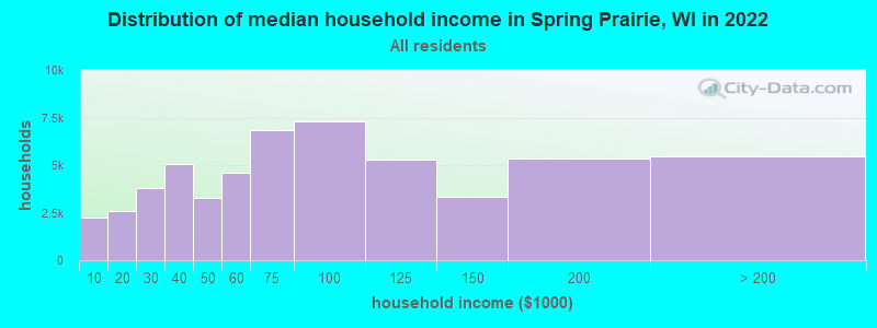
| Spring Prairie: | $93,626 |
| WI: | $70,996 |
Estimated per capita income in 2022: $44,913 (it was $22,471 in 2000)
Spring Prairie town income, earnings, and wages data
Estimated median house or condo value in 2022: $344,986 (it was $152,800 in 2000)
| Spring Prairie: | $344,986 |
| WI: | $252,800 |
Mean prices in 2022: all housing units: $370,020; detached houses: $392,613; townhouses or other attached units: $227,011; in 2-unit structures: $217,528; in 3-to-4-unit structures: $189,298; in 5-or-more-unit structures: $213,200; mobile homes: $55,686
Spring Prairie, WI residents, houses, and apartments details
Detailed information about poverty and poor residents in Spring Prairie, WI
Compare current foreclosures near Spring Prairie, WI:
| Photo | Address | Area | Beds / Baths | Price | Details |
|---|---|---|---|---|---|

|
#1
359th Ave
Twin Lakes, WI 53181
|
1,053 sq. feet
|
1 baths 2 beds |
$212,000
|
show details |

|
#2
County Road O S
Delavan, WI 53115
|
2,080 sq. feet
|
2 baths 3 beds |
$379,900
|
show details |

|
#3
Romin Rd
Lake Geneva, WI 53147
|
1,450 sq. feet
|
1 baths 3 beds |
show details | |

|
#4
Bayberry Dr
Waukesha, WI 53189
|
2,155 sq. feet
|
2 baths 3 beds |
show details | |

|
#5
Lily Lake Rd
Burlington, WI 53105
|
1,640 sq. feet
|
2 baths 3 beds |
show details | |

|
#6
E State St
Burlington, WI 53105
|
- sq. feet
|
1 baths 3 beds |
show details | |

|
#7
334th Ave
Burlington, WI 53105
|
871 sq. feet
|
2 baths 2 beds |
show details | |

|
#8
67th St
Salem, WI 53168
|
1,453 sq. feet
|
1 baths 2 beds |
show details | |

|
#9
389th Ave
Burlington, WI 53105
|
1,328 sq. feet
|
1 baths 3 beds |
show details | |

|
#10
Toms Ave
Twin Lakes, WI 53181
|
1,651 sq. feet
|
1 baths 3 beds |
show details |
| Photo | Address | Area | Beds / Baths | Price | Details |
|---|---|---|---|---|---|

|
#11
280th Ave
Salem, WI 53168
|
2,149 sq. feet
|
2 baths 3 beds |
show details | |

|
#12
N School St
Silver Lake, WI 53170
|
2,218 sq. feet
|
2 baths 4 beds |
show details | |

|
#13
236th Ave
Salem, WI 53168
|
1,056 sq. feet
|
1 baths 3 beds |
show details | |

|
#14
328th Ave
Burlington, WI 53105
|
1,792 sq. feet
|
1 baths 3 beds |
show details | |

|
#15
76th St
Burlington, WI 53105
|
1,661 sq. feet
|
1 baths 3 beds |
show details | |

|
#16
Gatewood Dr
Twin Lakes, WI 53181
|
1,532 sq. feet
|
1 baths 4 beds |
show details | |

|
#17
68th St
Salem, WI 53168
|
1,450 sq. feet
|
1 baths 4 beds |
show details | |

|
#18
First St
Delavan, WI 53115
|
- sq. feet
|
- baths - beds |
show details | |

|
#19
State Road 50
Delavan, WI 53115
|
- sq. feet
|
- baths - beds |
show details | |

|
#20
N Shore Dr
Muskego, WI 53150
|
- sq. feet
|
- baths - beds |
show details |
| Photo | Address | Area | Beds / Baths | Price | Details |
|---|---|---|---|---|---|

|
#21
Jennifer Ct
Muskego, WI 53150
|
- sq. feet
|
- baths - beds |
show details | |

|
#22
Hillview Dr
Mukwonago, WI 53149
|
- sq. feet
|
- baths - beds |
show details | |

|
#23
Tombeau Blvd
Genoa City, WI 53128
|
- sq. feet
|
- baths - beds |
show details | |

|
#24
State Road 59
Eagle, WI 53119
|
- sq. feet
|
- baths - beds |
show details | |

|
#25
Putnam St
Big Bend, WI 53103
|
- sq. feet
|
- baths - beds |
show details | |

|
#26
N Lakeshore Dr
Elkhorn, WI 53121
|
- sq. feet
|
- baths - beds |
show details | |

|
#27
Milwaukee Ave
Big Bend, WI 53103
|
- sq. feet
|
- baths - beds |
show details | |

|
#28
Westgate Dr
Mukwonago, WI 53149
|
- sq. feet
|
- baths - beds |
show details | |

|
#29
Bassett Road
Bassett, WI 53101
|
- sq. feet
|
- baths - beds |
show details | |

|
#30
Wisconsin Rd
Genoa City, WI 53128
|
- sq. feet
|
- baths - beds |
show details |
| Photo | Address | Area | Beds / Baths | Price | Details |
|---|---|---|---|---|---|

|
#31
312th Ave
Salem, WI 53168
|
- sq. feet
|
- baths - beds |
show details | |

|
#32
Lakecrest Dr
Mukwonago, WI 53149
|
- sq. feet
|
- baths - beds |
show details | |

|
#33
Chestnut Dr
Mukwonago, WI 53149
|
- sq. feet
|
- baths - beds |
show details | |

|
#34
River Park Cir W
Mukwonago, WI 53149
|
- sq. feet
|
- baths - beds |
show details | |

|
#35
Babcock Rd
Elkhorn, WI 53121
|
- sq. feet
|
- baths - beds |
show details | |

|
#36
45th St Lot 25
Burlington, WI 53105
|
- sq. feet
|
- baths - beds |
show details | |

|
#37
National Ave, Apt 7
Mukwonago, WI 53149
|
- sq. feet
|
- baths - beds |
show details | |

|
#38
Casper Dr
Mukwonago, WI 53149
|
- sq. feet
|
- baths - beds |
show details | |

|
#39
Lakeside Dr
Mukwonago, WI 53149
|
- sq. feet
|
- baths - beds |
show details | |

|
#40
Van Buren St
Kansasville, WI 53139
|
- sq. feet
|
- baths - beds |
show details |
| Photo | Address | Area | Beds / Baths | Price | Details |
|---|---|---|---|---|---|

|
#41
Honey Creek Rd # 1338
East Troy, WI 53120
|
- sq. feet
|
- baths - beds |
show details | |

|
#42
368th Ave
Burlington, WI 53105
|
- sq. feet
|
- baths - beds |
show details | |

|
#43
County Rd E
Mukwonago, WI 53149
|
- sq. feet
|
- baths - beds |
show details | |

|
#44
Daisy Dr
Genoa City, WI 53128
|
- sq. feet
|
- baths - beds |
show details | |

|
#45
Florence Rd
Genoa City, WI 53128
|
- sq. feet
|
- baths - beds |
show details | |

|
#46
State Road 50, Lot 22
Lake Geneva, WI 53147
|
- sq. feet
|
- baths - beds |
show details | |

|
#47
Violet Rd
Genoa City, WI 53128
|
- sq. feet
|
- baths - beds |
show details | |

|
#48
Violet Rd
Genoa City, WI 53128
|
- sq. feet
|
- baths - beds |
show details | |

|
#49
County Rd N
Eagle, WI 53119
|
- sq. feet
|
- baths - beds |
show details | |

|
Check over 1 million property listings on Foreclosure.com!
|
browse all offers | |||

- 2,08095.4%White alone
- 612.8%Hispanic
- 190.9%Two or more races
- 90.4%Black alone
- 50.2%Asian alone
- 40.2%Other race alone
- 30.1%American Indian alone
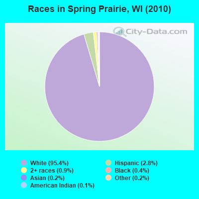
Races in Spring Prairie detailed stats: ancestries, foreign born residents, place of birth
 Recent articles from our blog. Our writers, many of them Ph.D. graduates or candidates, create easy-to-read articles on a wide variety of topics.

Latest news from Spring Prairie, WI collected exclusively by city-data.com from local newspapers, TV, and radio stations
Ancestries: German (47.7%), Irish (14.3%), Polish (11.6%), English (10.0%), United States (5.4%), Norwegian (5.1%).
Current Local Time: CST time zone
Elevation: 1018 feet
Land area: 35.7 square miles.
Population density: 61 people per square mile (very low).
17 residents are foreign born
| This town: | 0.8% |
| Wisconsin: | 3.6% |
| Spring Prairie town: | 1.6% ($2,417) |
| Wisconsin: | 2.0% ($2,245) |
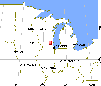
Nearest city with pop. 50,000+: Waukesha, WI  (21.2 miles , pop. 64,825).
Nearest city with pop. 200,000+: Milwaukee, WI (30.9 miles , pop. 596,974).
Nearest city with pop. 1,000,000+: Chicago, IL (69.9 miles , pop. 2,896,016).
Nearest cities:
), ), ), Latitude: 42.72 N, Longitude: 88.36 W
Area code commonly used in this area: 262

| Here: | 2.5% |
| Wisconsin: | 2.7% |
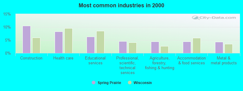
- Construction (10.4%)
- Health care (8.3%)
- Educational services (6.3%)
- Professional, scientific, technical services (4.5%)
- Agriculture, forestry, fishing & hunting (4.4%)
- Accommodation & food services (4.4%)
- Metal & metal products (4.4%)
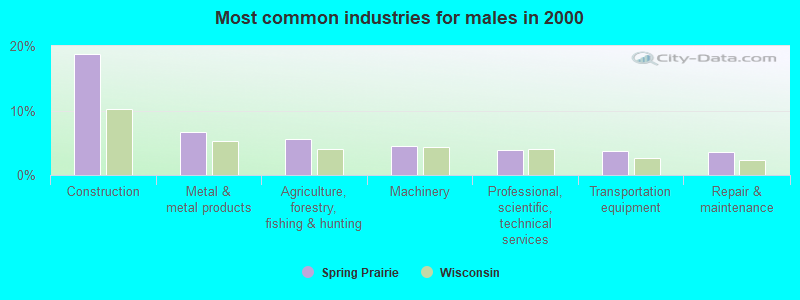
- Construction (18.7%)
- Metal & metal products (6.6%)
- Agriculture, forestry, fishing & hunting (5.7%)
- Machinery (4.5%)
- Professional, scientific, technical services (3.9%)
- Transportation equipment (3.7%)
- Repair & maintenance (3.6%)
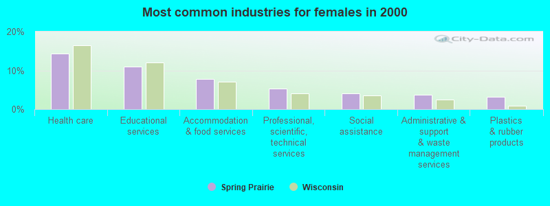
- Health care (14.3%)
- Educational services (10.9%)
- Accommodation & food services (7.7%)
- Professional, scientific, technical services (5.3%)
- Social assistance (4.2%)
- Administrative & support & waste management services (3.8%)
- Plastics & rubber products (3.2%)
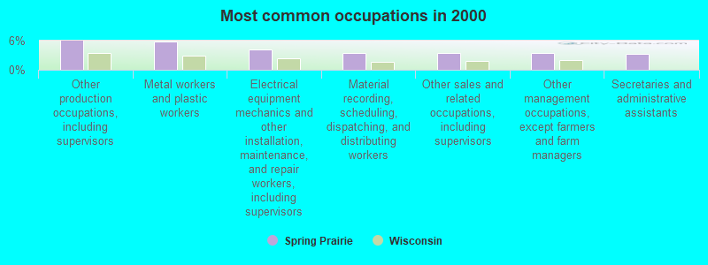
- Other production occupations, including supervisors (5.9%)
- Metal workers and plastic workers (5.8%)
- Electrical equipment mechanics and other installation, maintenance, and repair workers, including supervisors (4.1%)
- Material recording, scheduling, dispatching, and distributing workers (3.5%)
- Other sales and related occupations, including supervisors (3.4%)
- Other management occupations, except farmers and farm managers (3.4%)
- Secretaries and administrative assistants (3.2%)
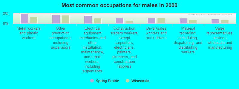
- Metal workers and plastic workers (7.9%)
- Other production occupations, including supervisors (7.1%)
- Electrical equipment mechanics and other installation, maintenance, and repair workers, including supervisors (6.6%)
- Construction traders workers except carpenters, electricians, painters, plumbers, and construction laborers (4.7%)
- Driver/sales workers and truck drivers (4.5%)
- Material recording, scheduling, dispatching, and distributing workers (4.4%)
- Sales representatives, services, wholesale and manufacturing (3.7%)

- Secretaries and administrative assistants (7.0%)
- Other production occupations, including supervisors (4.5%)
- Other management occupations, except farmers and farm managers (4.3%)
- Retail sales workers, except cashiers (4.0%)
- Preschool, kindergarten, elementary, and middle school teachers (4.0%)
- Other sales and related occupations, including supervisors (3.8%)
- Metal workers and plastic workers (3.4%)
Average climate in Spring Prairie, Wisconsin
Based on data reported by over 4,000 weather stations


(lower is better)
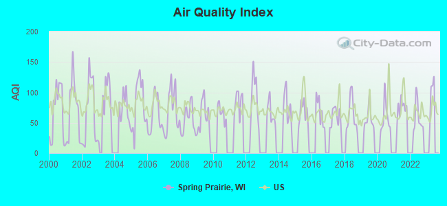
Air Quality Index (AQI) level in 2022 was 58.3. This is better than average.
| City: | 58.3 |
| U.S.: | 72.6 |
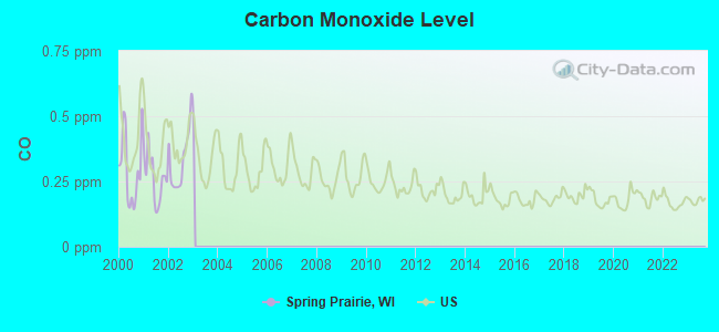
Carbon Monoxide (CO) [ppm] level in 2002 was 0.333. This is worse than average. Closest monitor was 20.9 miles away from the city center.
| City: | 0.333 |
| U.S.: | 0.251 |
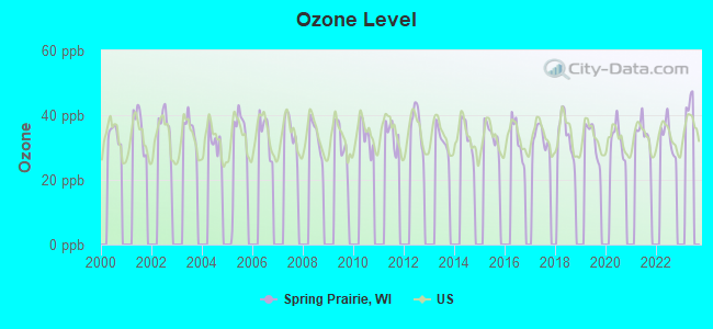
Ozone [ppb] level in 2022 was 33.4. This is about average. Closest monitor was 7.5 miles away from the city center.
| City: | 33.4 |
| U.S.: | 33.3 |
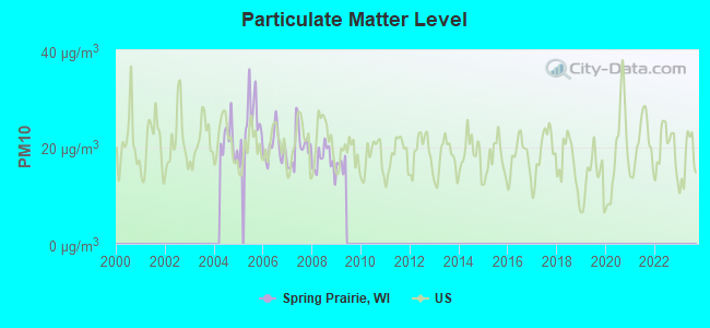
Particulate Matter (PM10) [µg/m3] level in 2008 was 17.3. This is about average. Closest monitor was 22.1 miles away from the city center.
| City: | 17.3 |
| U.S.: | 19.2 |
Tornado activity:
Spring Prairie-area historical tornado activity is slightly above Wisconsin state average. It is 40% greater than the overall U.S. average.
On 4/27/1984, a category F4 (max. wind speeds 207-260 mph) tornado 18.2 miles away from the Spring Prairie town center killed one person and injured 14 people and caused between $500,000 and $5,000,000 in damages.
On 4/21/1967, a category F4 tornado 25.6 miles away from the town center killed 24 people and injured 450 people and caused between $50,000 and $500,000 in damages.
Earthquake activity:
Spring Prairie-area historical earthquake activity is significantly above Wisconsin state average. It is 26% greater than the overall U.S. average.On 4/18/2008 at 09:36:59, a magnitude 5.4 (5.1 MB, 4.8 MS, 5.4 MW, 5.2 MW, Class: Moderate, Intensity: VI - VII) earthquake occurred 296.0 miles away from Spring Prairie center
On 6/28/2004 at 06:10:52, a magnitude 4.2 (4.2 MW, Depth: 6.2 mi, Class: Light, Intensity: IV - V) earthquake occurred 91.3 miles away from Spring Prairie center
On 6/10/1987 at 23:48:54, a magnitude 5.1 (4.9 MB, 4.4 MS, 4.6 MS, 5.1 LG) earthquake occurred 270.6 miles away from the city center
On 4/18/2008 at 09:36:59, a magnitude 5.2 (5.2 MW, Depth: 8.9 mi) earthquake occurred 296.1 miles away from Spring Prairie center
On 2/10/2010 at 09:59:35, a magnitude 3.8 (3.8 MW, Depth: 6.2 mi, Class: Light, Intensity: II - III) earthquake occurred 52.2 miles away from Spring Prairie center
On 5/2/2015 at 16:23:07, a magnitude 4.2 (4.2 MW, Depth: 2.8 mi) earthquake occurred 153.2 miles away from the city center
Magnitude types: regional Lg-wave magnitude (LG), body-wave magnitude (MB), surface-wave magnitude (MS), moment magnitude (MW)
Natural disasters:
The number of natural disasters in Walworth County (12) is smaller than the US average (15).Major Disasters (Presidential) Declared: 8
Emergencies Declared: 4
Causes of natural disasters: Floods: 6, Storms: 6, Tornadoes: 3, Winter Storms: 2, Drought: 1, Hurricane: 1, Snow: 1, Snowstorm: 1, Wind: 1, Other: 1 (Note: some incidents may be assigned to more than one category).

Hospitals and medical centers near Spring Prairie:
- AURORA MEMORIAL HSPTL BURLINGTON Acute Care Hospitals (about 5 miles away; BURLINGTON, WI)
- KINDRED NURSING AND REHAB-BURLINGTON (Nursing Home, about 6 miles away; BURLINGTON, WI)
- MOUNT CARMEL CARE CENTER (Nursing Home, about 6 miles away; BURLINGTON, WI)
- DAVITA - LAKE GENEVA DIALYSIS (Dialysis Facility, about 9 miles away; LAKE GENEVA, WI)
- PURITY DIALYSIS - MUKWONAGO (Dialysis Facility, about 10 miles away; MUKWONAGO, WI)
- GENEVA LAKE MANOR (Nursing Home, about 10 miles away; LAKE GENEVA, WI)
- HOLTON MANOR (Nursing Home, about 10 miles away; ELKHORN, WI)
Airports located in Spring Prairie:
- Fletcher Airport (9WI8) (Runways: 1)
Colleges/universities with over 2000 students nearest to Spring Prairie:
- Carroll University (about 21 miles; Waukesha, WI; Full-time enrollment: 3,313)
- University of Wisconsin-Whitewater (about 22 miles; Whitewater, WI; FT enrollment: 11,124)
- Waukesha County Technical College (about 25 miles; Pewaukee, WI; FT enrollment: 4,415)
- University of Wisconsin-Parkside (about 27 miles; Kenosha, WI; FT enrollment: 3,843)
- Gateway Technical College (about 28 miles; Kenosha, WI; FT enrollment: 5,089)
- Carthage College (about 29 miles; Kenosha, WI; FT enrollment: 3,130)
- College of Lake County (about 31 miles; Grayslake, IL; FT enrollment: 11,041)
Points of interest:
Church in Spring Prairie: German Settlement Church (A). Display/hide its location on the map
Cemeteries: Hickory Grove Cemetery (1), German Settlement Cemetery (2), Vienna Cemetery (3). Display/hide their locations on the map
Reservoir: Honey Lake (A). Display/hide its location on the map
Birthplace of: Rollin D. Salisbury - Science writer.
| This town: | 2.7 people |
| Wisconsin: | 2.4 people |
| This town: | 80.4% |
| Whole state: | 64.4% |
| This town: | 4.6% |
| Whole state: | 7.3% |
Likely homosexual households (counted as self-reported same-sex unmarried-partner households)
- Lesbian couples: 0.0% of all households
- Gay men: 0.4% of all households
| This town: | 3.1% |
| Whole state: | 8.7% |
| This town: | 1.1% |
| Whole state: | 3.7% |
For population 15 years and over in Spring Prairie:
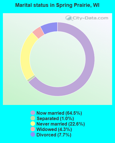
- Never married: 22.6%
- Now married: 64.5%
- Separated: 1.0%
- Widowed: 4.3%
- Divorced: 7.7%
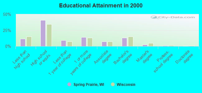
For population 25 years and over in Spring Prairie:
- High school or higher: 88.1%
- Bachelor's degree or higher: 17.2%
- Graduate or professional degree: 4.0%
- Unemployed: 4.4%
- Mean travel time to work (commute): 27.5 minutes
| Here: | 8.3 |
| Wisconsin average: | 11.0 |
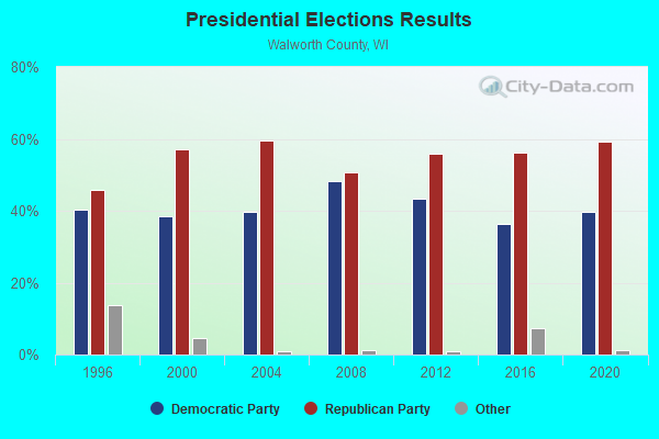
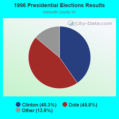
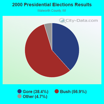

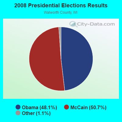
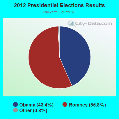

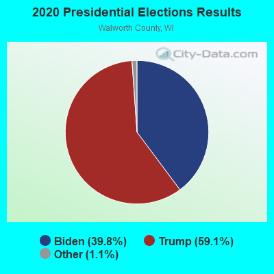
Graphs represent county-level data. Detailed 2008 Election Results
Religion statistics for Spring Prairie, WI (based on Walworth County data)
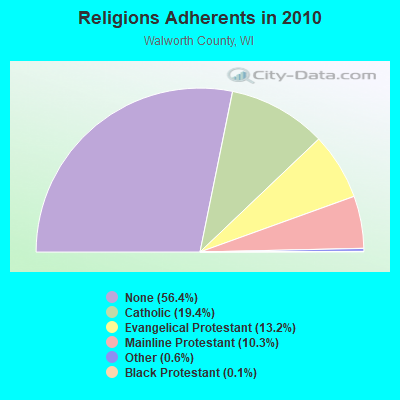
| Religion | Adherents | Congregations |
|---|---|---|
| Catholic | 19,868 | 8 |
| Evangelical Protestant | 13,451 | 51 |
| Mainline Protestant | 10,563 | 40 |
| Other | 584 | 5 |
| Black Protestant | 122 | 1 |
| None | 57,640 | - |
Food Environment Statistics:
| Walworth County: | 2.09 / 10,000 pop. |
| Wisconsin: | 1.86 / 10,000 pop. |
| Walworth County: | 0.10 / 10,000 pop. |
| State: | 0.11 / 10,000 pop. |
| This county: | 0.60 / 10,000 pop. |
| Wisconsin: | 0.38 / 10,000 pop. |
| Walworth County: | 4.59 / 10,000 pop. |
| Wisconsin: | 4.12 / 10,000 pop. |
| Walworth County: | 10.97 / 10,000 pop. |
| Wisconsin: | 8.64 / 10,000 pop. |
| This county: | 6.8% |
| Wisconsin: | 7.6% |
| Here: | 25.1% |
| Wisconsin: | 27.5% |
| Here: | 15.0% |
| Wisconsin: | 13.0% |
Strongest AM radio stations in Spring Prairie:
- WTMJ (620 AM; 50 kW; MILWAUKEE, WI; Owner: JOURNAL BROADCAST CORPORATION)
- WISN (1130 AM; 50 kW; MILWAUKEE, WI; Owner: CAPSTAR TX LIMITED PARTNERSHIP)
- WGN (720 AM; 50 kW; CHICAGO, IL; Owner: WGN CONTINENTAL BROADCASTING CO.)
- WSCR (670 AM; 50 kW; CHICAGO, IL; Owner: INFINITY BROADCASTING OPERATIONS, INC.)
- WBBM (780 AM; 50 kW; CHICAGO, IL; Owner: INFINITY BROADCASTING OPERATIONS, INC.)
- WAUK (1510 AM; daytime; 10 kW; WAUKESHA, WI; Owner: WALT-WEST WISCONSIN, INC.)
- WMVP (1000 AM; 50 kW; CHICAGO, IL; Owner: ABC, INC.)
- WOKY (920 AM; 5 kW; MILWAUKEE, WI; Owner: CLEAR CHANNEL BROADCASTING LICENSES, INC.)
- WKSH (1640 AM; 10 kW; SUSSEX, WI; Owner: ABC, INC.)
- WZRK (1550 AM; 1 kW; LAKE GENEVA, WI)
- WEMP (1250 AM; 5 kW; MILWAUKEE, WI; Owner: ENTERCOM MILWAUKEE LICENSE, LLC)
- WLS (890 AM; 50 kW; CHICAGO, IL; Owner: WLS, INC.)
- WMCS (1290 AM; 5 kW; GREENFIELD, WI; Owner: MILWAUKEE RADIO ALLIANCE, LLC)
Strongest FM radio stations in Spring Prairie:
- WLKG (96.1 FM; LAKE GENEVA, WI; Owner: CTJ COMMUNICATIONS, LTD.)
- WFZH (105.3 FM; MUKWONAGO, WI; Owner: CARON BROADCASTING, INC.)
- WHAD (90.7 FM; DELAFIELD, WI; Owner: STATE OF WISCONSIN - EDUCATIONAL COMMUNICATIONS BOARD)
- WKKV-FM (100.7 FM; RACINE, WI; Owner: CLEAR CHANNEL BROADCASTING LICENSES, INC.)
- WBSD (89.1 FM; BURLINGTON, WI; Owner: BURLINGTON AREA SCHOOL DISTRICT)
- WJZI (93.3 FM; MILWAUKEE, WI; Owner: MILWAUKEE RADIO ALLIANCE, LLC)
- WVCY-FM (107.7 FM; MILWAUKEE, WI; Owner: VCY AMERICA, INC.)
- WMIL-FM (106.1 FM; WAUKESHA, WI; Owner: CLEAR CHANNEL BROADCASTING LICENSES, INC.)
- WKTI-FM (94.5 FM; MILWAUKEE, WI; Owner: JOURNAL BROADCAST CORPORATION)
- WLTQ (97.3 FM; MILWAUKEE, WI; Owner: CAPSTAR TX LIMITED PARTNERSHIP)
- WUWM (89.7 FM; MILWAUKEE, WI; Owner: BOARD OF REGENTS, UNIVERSITY OF WISCONSIN SYSTEM)
- WXSS (103.7 FM; WAUWATOSA, WI; Owner: ENTERCOM MILWAUKEE LICENSE, LLC)
- WMYX-FM (99.1 FM; MILWAUKEE, WI; Owner: ENTERCOM MILWAUKEE LICENSE, LLC)
- WKLH (96.5 FM; MILWAUKEE, WI; Owner: LAKEFRONT COMMUNICATIONS, LLC)
- WMWK (88.1 FM; MILWAUKEE, WI; Owner: FAMILY STATIONS, INC.)
- WLUM-FM (102.1 FM; MILWAUKEE, WI; Owner: MILWAUKEE RADIO ALLIANCE, LLC)
- WSLD (104.5 FM; WHITEWATER, WI; Owner: WPW BROADCASTING, INC.)
- WEZY (92.1 FM; RACINE, WI; Owner: RACINE BROADCASTING, L.L.C.)
- WWDV (96.9 FM; ZION, IL; Owner: BONNEVILLE HOLDING COMPANY)
- WSJY (107.3 FM; FORT ATKINSON, WI; Owner: NEWRADIO GROUP, LLC)
TV broadcast stations around Spring Prairie:
- W64CQ (Channel 64; ARLINGTON HEIGHTS, IL; Owner: TRINITY BROADCASTING NETWORK)
- WJJA (Channel 49; RACINE, WI; Owner: TV-49, INC.)
- WPXE (Channel 55; KENOSHA, WI; Owner: PAXSON MILWAUKEE LICENSE, INC.)
- WDJT-TV (Channel 58; MILWAUKEE, WI; Owner: WDJT-TV LIMITED PARTNERSHIP)
- WISN-TV (Channel 12; MILWAUKEE, WI; Owner: WISN HEARST-ARGYLE TV, INC. (CA CORP.))
- WMVS (Channel 10; MILWAUKEE, WI; Owner: MILWAUKEE AREA TECHNICAL COLLEGE DISTRICT BOARD)
- WMVT (Channel 36; MILWAUKEE, WI; Owner: MILWAUKEE AREA TECHNICAL COLLEGE DISTRICT BOARD)
- WCGV-TV (Channel 24; MILWAUKEE, WI; Owner: WCGV LICENSEE, LLC)
- WMLW-CA (Channel 46; MILWAUKEE, WI; Owner: CHANNEL 41 AND 63 LIMITED PARTNERSHIP)
- W63CU (Channel 63; MILWAUKEE, WI; Owner: CHANNEL 41 AND 63 LIMITED PARTNERSHIP)
- W34CK (Channel 34; ARLINGTON HEIGHTS, IL; Owner: FIRST UNITED, INC.)
- WVTV (Channel 18; MILWAUKEE, WI; Owner: WVTV LICENSEE, INC.)
- WTMJ-TV (Channel 4; MILWAUKEE, WI; Owner: JOURNAL BROADCAST CORPORATION)
- WVCY-TV (Channel 30; MILWAUKEE, WI; Owner: VCY AMERICA, INC.)
- WTAS-LP (Channel 43; WAUKESHA, WI; Owner: WAUKESHA TOWER ASSOCIATES)
- WITI (Channel 6; MILWAUKEE, WI; Owner: WITI LICENSE,INC.)
- WMKE-CA (Channel 7; MILWAUKEE, WI; Owner: KM LPTV OF MILWAUKEE, L.L.C.)
- National Bridge Inventory (NBI) Statistics
- 5Number of bridges
- 23ft / 7.0mTotal length
- 6,598Total average daily traffic
- 312Total average daily truck traffic
- 8,427Total future (year 2037) average daily traffic
FCC Registered Broadcast Land Mobile Towers:
1- 1/16 Mi N (Lat: 42.693917 Lon: -88.403694), Type: Tower, Structure height: 79 m, Overall height: 81 m, Call Sign: KLJ361,
Assigned Frequencies: 48.9000 MHz, Grant Date: 05/12/2015, Expiration Date: 05/21/2025, Cancellation Date: 01/12/2021, Certifier: Steven R Martz, Registrant: Anr Pipeline Company, 5250 Corporate Drive, Troy, MI 48098, Phone: (248) 205-4520, Fax: (248) 205-4620, Email:
FCC Registered Microwave Towers:
1- STATION, 1/16 Mi N Of (Lat: 42.693889 Lon: -88.403694), Overall height: 80.8 m, Call Sign: KSD94,
Assigned Frequencies: 6765.00 MHz, 6745.00 MHz, Grant Date: 04/01/2011, Expiration Date: 05/22/2021, Cancellation Date: 04/21/2021, Registrant: Transcanada, 5250 Corporate Drive, Troy, MI 48098, Phone: (248) 205-7464, Fax: (248) 205-4464, Email:
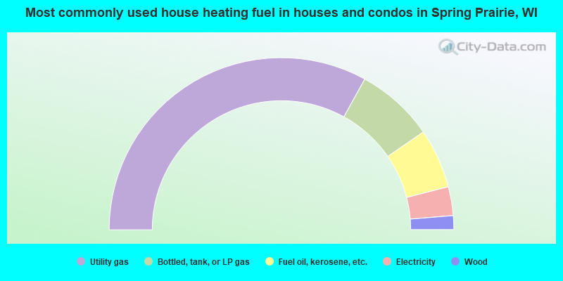
- 66.0%Utility gas
- 14.7%Bottled, tank, or LP gas
- 11.2%Fuel oil, kerosene, etc.
- 5.4%Electricity
- 2.6%Wood
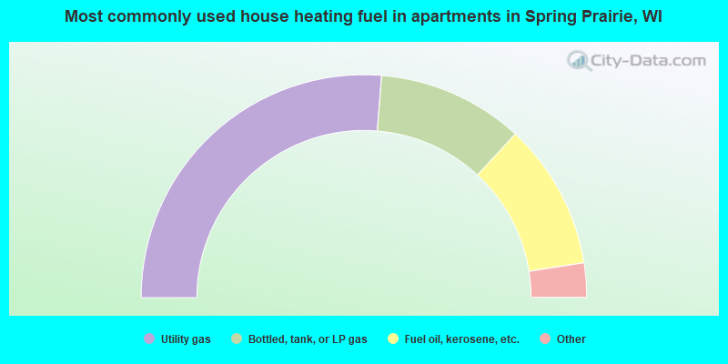
- 52.5%Utility gas
- 21.2%Bottled, tank, or LP gas
- 21.2%Fuel oil, kerosene, etc.
- 2.5%Electricity
- 2.5%Other fuel
Spring Prairie compared to Wisconsin state average:
- Unemployed percentage significantly below state average.
- Black race population percentage significantly below state average.
- Hispanic race population percentage below state average.
- Foreign-born population percentage significantly below state average.
- Renting percentage significantly below state average.
- Length of stay since moving in significantly above state average.
- Number of rooms per house significantly below state average.
- House age significantly below state average.