Estimated median house or condo value in 2022: $345,095 (it was $120,500 in 2000)
Southwest Harbor:
$345,095
ME:
$290,600
Mean prices in 2022:all housing units: $379,336; detached houses: $396,802; townhouses or other attached units: $600,716; in 2-unit structures: $274,479; in 3-to-4-unit structures: $212,346; in 5-or-more-unit structures: $146,369; mobile homes: $158,183; occupied boats, rvs, vans, etc.: $16,454March 2022 cost of living index in Southwest Harbor: 94.6 (less than average, U.S. average is 100)
According to our research of Maine and other state lists, there was 1 registered sex offender living in Southwest Harbor, Maine as of May 08, 2024. The ratio of all residents to sex offenders in Southwest Harbor is 1,764 to 1. The ratio of registered sex offenders to all residents in this city is much lower than the state average.
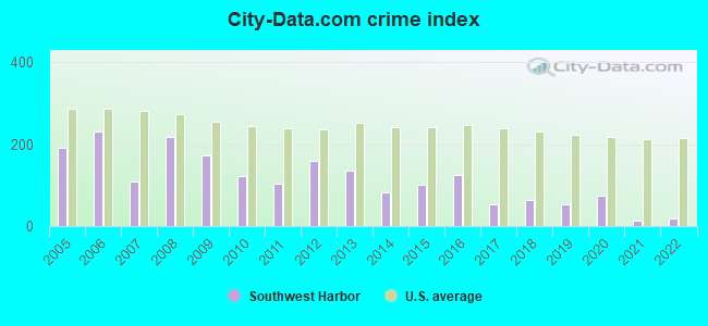
Crime rates in Southwest Harbor by year
Type
2009
2010
2011
2012
2013
2014
2015
2016
2017
2018
2019
2020
2021
2022
Murders (per 100,000)
0 (0.0)
0 (0.0)
0 (0.0)
0 (0.0)
0 (0.0)
0 (0.0)
0 (0.0)
0 (0.0)
0 (0.0)
0 (0.0)
0 (0.0)
0 (0.0)
0 (0.0)
0 (0.0)
Rapes (per 100,000)
0 (0.0)
0 (0.0)
0 (0.0)
0 (0.0)
0 (0.0)
0 (0.0)
0 (0.0)
0 (0.0)
0 (0.0)
0 (0.0)
0 (0.0)
0 (0.0)
0 (0.0)
0 (0.0)
Robberies (per 100,000)
0 (0.0)
0 (0.0)
0 (0.0)
0 (0.0)
0 (0.0)
0 (0.0)
0 (0.0)
1 (56.4)
0 (0.0)
0 (0.0)
0 (0.0)
0 (0.0)
0 (0.0)
0 (0.0)
Assaults (per 100,000)
0 (0.0)
1 (56.7)
1 (56.7)
0 (0.0)
0 (0.0)
0 (0.0)
0 (0.0)
1 (56.4)
0 (0.0)
0 (0.0)
1 (55.7)
0 (0.0)
0 (0.0)
0 (0.0)
Burglaries (per 100,000)
13 (670.4)
6 (340.1)
4 (226.8)
11 (621.1)
13 (736.5)
4 (224.7)
3 (169.2)
2 (112.7)
3 (168.5)
4 (224.8)
0 (0.0)
2 (111.4)
1 (55.7)
2 (108.9)
Thefts (per 100,000)
59 (3,043)
36 (2,041)
34 (1,927)
51 (2,880)
37 (2,096)
30 (1,685)
35 (1,974)
40 (2,255)
19 (1,067)
21 (1,180)
17 (947.1)
28 (1,560)
4 (222.7)
5 (272.3)
Auto thefts (per 100,000)
1 (51.6)
1 (56.7)
0 (0.0)
0 (0.0)
0 (0.0)
0 (0.0)
2 (112.8)
0 (0.0)
0 (0.0)
0 (0.0)
1 (55.7)
1 (55.7)
0 (0.0)
0 (0.0)
Arson (per 100,000)
0 (0.0)
0 (0.0)
0 (0.0)
0 (0.0)
0 (0.0)
0 (0.0)
0 (0.0)
0 (0.0)
0 (0.0)
0 (0.0)
1 (55.7)
0 (0.0)
0 (0.0)
0 (0.0)
City-Data.com crime index
172.8
121.3
104.3
158.7
135.4
83.1
99.8
126.3
54.5
63.0
53.5
74.7
12.8
18.5
The City-Data.com crime index weighs serious crimes and violent crimes more heavily. Higher means more crime, U.S. average is 246.1. It adjusts for the number of visitors and daily workers commuting into cities.
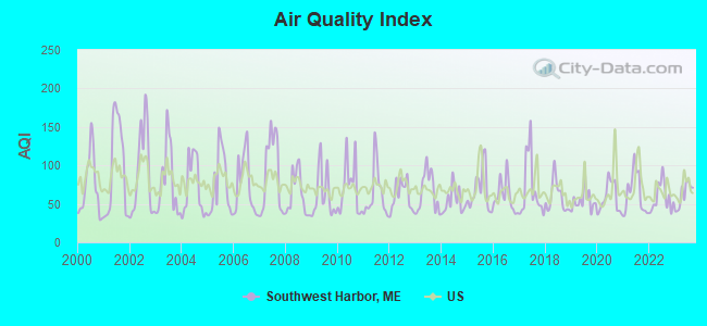
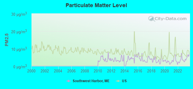
Air Quality Index (AQI) level in 2023 was 61.9. This is about average.
City:
61.9
U.S.:
72.6
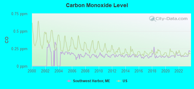
Carbon Monoxide (CO) [ppm] level in 2023 was 0.172. This is significantly better than average.Closest monitor was 6.9 miles away from the city center.
City:
0.172
U.S.:
0.251
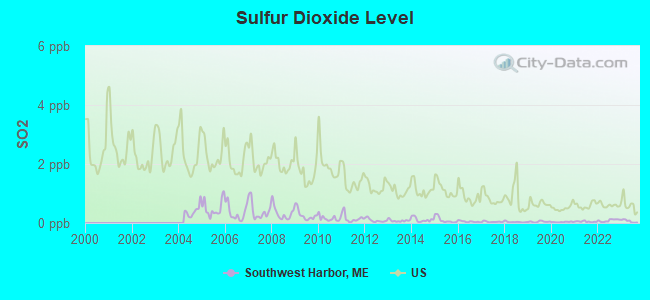
Sulfur Dioxide (SO2) [ppb] level in 2023 was 0.0636. This is significantly better than average.Closest monitor was 2.8 miles away from the city center.
City:
0.0636
U.S.:
1.5147
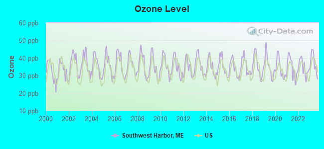
Ozone [ppb] level in 2023 was 37.0. This is about average.Closest monitor was 0.6 miles away from the city center.
City:
37.0
U.S.:
33.3
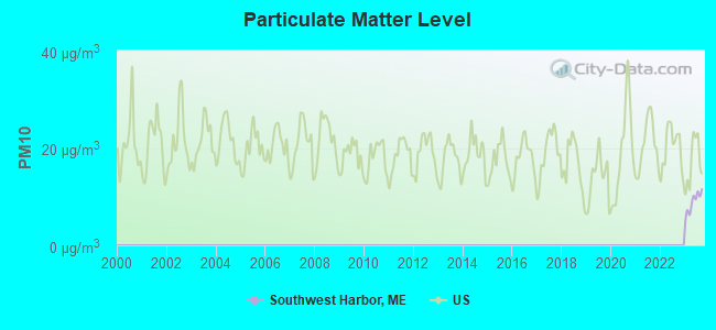
Particulate Matter (PM2.5) [µg/m3] level in 2023 was 4.90. This is significantly better than average.Closest monitor was 7.5 miles away from the city center.
City:
4.90
U.S.:
8.11
Earthquake activity:
Southwest Harbor-area historical earthquake activity is significantly above Maine state average. It is 80% smaller than the overall U.S. average.
On 10/16/2012 at 23:12:25, a magnitude 4.7 (4.7 ML, Depth: 10.0 mi, Class: Light, Intensity: IV - V) earthquake occurred 125.4 miles away from the city center On 4/20/2002 at 10:50:47, a magnitude 5.3 (5.3 ML, Depth: 3.0 mi, Class: Moderate, Intensity: VI - VII) earthquake occurred 266.1 miles away from the city center On 4/20/2002 at 10:50:47, a magnitude 5.2 (5.2 MB, 4.2 MS, 5.2 MW, 5.0 MW) earthquake occurred 267.1 miles away from the city center On 1/19/1982 at 00:14:42, a magnitude 4.7 (4.5 MB, 4.7 MD, 4.5 LG) earthquake occurred 172.0 miles away from Southwest Harbor center On 10/7/1983 at 10:18:46, a magnitude 5.3 (5.1 MB, 5.3 LG, 5.1 ML) earthquake occurred 299.7 miles away from Southwest Harbor center On 10/3/2006 at 00:07:38, a magnitude 3.7 (3.7 MD, Depth: 6.2 mi, Class: Light, Intensity: II - III) earthquake occurred 10.6 miles away from Southwest Harbor center Magnitude types: regional Lg-wave magnitude (LG), body-wave magnitude (MB), duration magnitude (MD), local magnitude (ML), surface-wave magnitude (MS), moment magnitude (MW)
Natural disasters:
The number of natural disasters in Hancock County (18) is near the US average (15). Major Disasters (Presidential) Declared: 11 Emergencies Declared: 6
Causes of natural disasters: Floods: 9, Storms: 8, Snows: 5, Blizzard: 1, Heavy Rain: 1, Hurricane: 1, Ice Storm: 1, Landslide: 1, Snowfall: 1, Wind: 1, Winter Storm: 1, Other: 2 (Note: some incidents may be assigned to more than one category).
Hospitals and medical centers near Southwest Harbor:
MOUNT DESERT ISLAND HOSPITAL Critical Access Hospitals (about 10 miles away; BAR HARBOR, ME)
SONOGEE ESTATES (Nursing Home, about 10 miles away; BAR HARBOR, ME)
SONOGEE REHABILITATION AND LIVING CENTER (Nursing Home, about 10 miles away; BAR HARBOR, ME)
Colleges/universities with over 2000 students nearest to Southwest Harbor:
Husson University (about 45 miles; Bangor, ME; Full-time enrollment: 2,421)
University of Maine (about 47 miles; Orono, ME; FT enrollment: 8,931)
University of Maine at Augusta (about 74 miles; Augusta, ME; FT enrollment: 3,204)
University of Maine at Farmington (about 95 miles; Farmington, ME; FT enrollment: 2,036)
Southern Maine Community College (about 105 miles; South Portland, ME; FT enrollment: 4,666)
University of Southern Maine (about 107 miles; Portland, ME; FT enrollment: 6,647)
Saint Joseph's College of Maine (about 112 miles; Standish, ME; FT enrollment: 2,010)
Public elementary/middle school in Southwest Harbor:
Notable locations in Southwest Harbor: Mount Desert Oceanarium (A), Southwest Harbor / Tremont Ambulance Association (B), Southwest Harbor Public Library (C), Southwest Harbor Volunteer Fire Department (D). Display/hide their locations on the map
Tourist attractions: Oceanarium (Museums; 172 Clark Point Road), Wendell Gilley Museum (Main & Herrick Road).
Hotels: Mansell House & Boat Rental (Shore Road), Moorings Inn (133 Shore Road), Harbor View Motel & Cottages (11 Ocean Way), Lindenwood Inn (118 Clark Point Rd).
Hancock County has a predicted average indoor radon screening level greater than 4 pCi/L (pico curies per liter) - Highest Potential
Drinking water stations with addresses in Southwest Harbor and their reported violations in the past:
SOUTHWEST HARBOR WATER DEPT (Population served: 2,460, Surface water):
Past health violations:
MCL, Average - Between APR-2011 and JUN-2011, Contaminant: TTHM. Follow-up actions: St Public Notif requested (JUN-13-2011), St Formal NOV issued (JUN-13-2011), St Public Notif received (AUG-11-2011), St AO (w/o penalty) issued (APR-06-2012), St BCA signed (APR-18-2012), St Compliance achieved (JUN-27-2012)
MCL, Average - Between JAN-2011 and MAR-2011, Contaminant: TTHM. Follow-up actions: St Public Notif requested (JUN-13-2011), St Formal NOV issued (JUN-13-2011), St Public Notif received (AUG-11-2011), St AO (w/o penalty) issued (APR-06-2012), St BCA signed (APR-18-2012), St Compliance achieved (JUN-27-2012)
MCL, Average - Between OCT-2010 and DEC-2010, Contaminant: TTHM. Follow-up actions: St BCA signed (NOV-03-2008), St Public Notif received (FEB-01-2011), St Public Notif requested (FEB-03-2011), St Formal NOV issued (FEB-03-2011), St AO (w/o penalty) issued (APR-06-2012), St BCA signed (APR-18-2012), St Compliance achieved (JUN-27-2012)
MCL, Average - Between JUL-2010 and SEP-2010, Contaminant: TTHM. Follow-up actions: St BCA signed (NOV-03-2008), St Public Notif requested (SEP-14-2010), St Formal NOV issued (SEP-14-2010), St Public Notif received (OCT-21-2010), St AO (w/o penalty) issued (APR-06-2012), St BCA signed (APR-18-2012), St Compliance achieved (JUN-27-2012)
MCL, Average - Between APR-2010 and JUN-2010, Contaminant: TTHM. Follow-up actions: St BCA signed (NOV-03-2008), St Public Notif requested (SEP-14-2010), St Formal NOV issued (SEP-14-2010), St Public Notif received (OCT-21-2010), St AO (w/o penalty) issued (APR-06-2012), St BCA signed (APR-18-2012), St Compliance achieved (JUN-27-2012)
MCL, Average - Between JAN-2010 and MAR-2010, Contaminant: TTHM. Follow-up actions: St BCA signed (NOV-03-2008), St Public Notif requested (MAY-21-2010), St Formal NOV issued (MAY-21-2010), St Public Notif received (JUN-07-2010), St AO (w/o penalty) issued (APR-06-2012), St BCA signed (APR-18-2012), St Compliance achieved (JUN-27-2012)
24 other older health violations
Past monitoring violations:
Monitoring and Reporting (DBP) - Between JUL-2012 and SEP-2012, Contaminant: Total Haloacetic Acids (HAA5). Follow-up actions: St Compliance achieved (OCT-24-2012), St Public Notif requested (NOV-14-2012), St Formal NOV issued (NOV-14-2012), St Public Notif received (JUN-11-2013)
Monitoring and Reporting (DBP) - Between JUL-2012 and SEP-2012, Contaminant: TTHM. Follow-up actions: St Compliance achieved (OCT-24-2012), St Public Notif requested (NOV-14-2012), St Formal NOV issued (NOV-14-2012), St Public Notif received (JUN-11-2013)
DEMUROS TOP OF THE HILL REST (Population served: 180, Groundwater):
Past monitoring violations:
2 routine major monitoring violations
One regular monitoring violation
WILD ACADIA FUN PARK (Population served: 60, Groundwater):
Past monitoring violations:
One routine major monitoring violation
MOUNT DESERT OCEANARIUM (Population served: 36, Groundwater):
Past health violations:
MCL, Monthly (TCR) - In MAY-2013, Contaminant: Coliform. Follow-up actions: St Formal NOV issued (JUN-03-2013), St Public Notif requested (JUN-03-2013)
MCL, Monthly (TCR) - In JUN-2005, Contaminant: Coliform. Follow-up actions: St Public Notif requested (JUL-08-2005), St Violation/Reminder Notice (JUL-08-2005), St Compliance achieved (JUL-20-2005), St Public Notif received (AUG-03-2005)
Past monitoring violations:
Monitoring, Repeat Major (TCR) - Between OCT-2012 and DEC-2012, Contaminant: Coliform (TCR). Follow-up actions: St Public Notif requested (JAN-25-2013), St Formal NOV issued (JAN-25-2013), St Compliance achieved (MAY-29-2013)
Monitoring, Repeat Major (TCR) - In JUL-2005, Contaminant: Coliform (TCR). Follow-up actions: St Public Notif requested (AUG-10-2005), St Violation/Reminder Notice (AUG-10-2005), St Compliance achieved (OCT-31-2005), St Intentional no-action (AUG-17-2011)
One routine major monitoring violation
Drinking water stations with addresses in Southwest Harbor that have no violations reported:
SMUGGLERS DEN (Address: 20 MAIN STREET , Population served: 250,Primary Water Source Type: Groundwater)
Average household size:
This town:
2.1 people
Maine:
2.3 people
Percentage of family households:
This town:
57.8%
Whole state:
62.9%
Percentage of households with unmarried partners:
This town:
8.5%
Whole state:
9.4%
Likely homosexual households (counted as self-reported same-sex unmarried-partner households)
Lesbian couples: 0.6% of all households
Gay men: 0.4% of all households
Residents with income below the poverty level in 2009:
This town:
12.0%
Whole state:
10.9%
Residents with income below 50% of the poverty level in 2009:
This town:
7.4%
Whole state:
4.1%
8 people in military barracks and dormitories (nondisciplinary) in 2010
33 people in military barracks, etc. in 2000
Banks with branches in Southwest Harbor (2011 data):
The First, N.A.: Southwest Harbor Branch at 350 Main Street, branch established on 1951/08/27. Info updated 2010/06/01: Bank assets: $1,338.8 mil, Deposits: $942.2 mil, headquarters in Damariscotta, ME, positive income, Commercial Lending Specialization, 14 total offices, Holding Company: First Bancorp, Inc., The
Bar Harbor Bank & Trust: Southwest Harbor Branch at 314 Main Street, branch established on 1951/08/27. Info updated 2007/04/24: Bank assets: $1,166.8 mil, Deposits: $723.6 mil, headquarters in Bar Harbor, ME, positive income, Commercial Lending Specialization, 12 total offices, Holding Company: Bar Harbor Bankshares
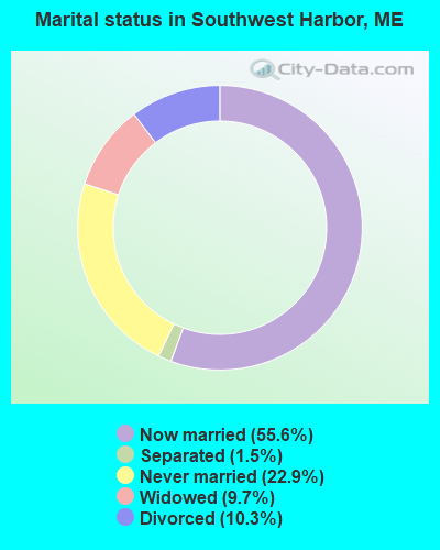
For population 15 years and over in Southwest Harbor:
Never married: 22.9%
Now married: 55.6%
Separated: 1.5%
Widowed: 9.7%
Divorced: 10.3%
For population 25 years and over in Southwest Harbor:
Religion statistics for Southwest Harbor, ME (based on Hancock County data)
Religion
Adherents
Congregations
Mainline Protestant
4,691
58
Catholic
2,523
9
Evangelical Protestant
1,288
23
Other
820
11
None
45,096
-
Source: Clifford Grammich, Kirk Hadaway, Richard Houseal, Dale E.Jones, Alexei Krindatch, Richie Stanley and Richard H.Taylor. 2012. 2010 U.S.Religion Census: Religious Congregations & Membership Study. Association of Statisticians of American Religious Bodies. Jones, Dale E., et al. 2002. Congregations and Membership in the United States 2000. Nashville, TN: Glenmary Research Center. Graphs represent county-level data
Shore Rd (Lat: 44.270083 Lon: -68.307806), Type: Building, Overall height: 6 m, Call Sign: KQU535, Licensee ID: L00006489, Assigned Frequencies: 156.500 MHz, 156.450 MHz, 156.800 MHz, Grant Date: 02/18/1997, Expiration Date: 04/10/2002, Cancellation Date: 07/14/2002, Registrant: Henry R Hinckley & Co, Shore Rd, Southwest Harbor, ME 04679
Coastal Cable Tower (Lat: 44.278417 Lon: -68.332806), Type: Tower, Overall height: 24 m, Call Sign: KWD32, Assigned Frequencies: 72.2800 MHz, Grant Date: 08/04/1995, Expiration Date: 10/05/2000, Cancellation Date: 05/06/2001, Registrant: Sea Jay Corp, Rockport, ME 04856
Clark Point Rd (Lat: 44.275917 Lon: -68.313639), Type: Tower, Call Sign: KYV736, Licensee ID: L00057686, Assigned Frequencies: 156.425 MHz, 156.450 MHz, 156.800 MHz, Grant Date: 08/23/1999, Expiration Date: 11/03/2004, Cancellation Date: 01/08/2005, Registrant: Village Industries Inc, Southwest Harbor, ME 04679
Clark Point Rd (Lat: 44.279250 Lon: -68.321972), Type: Building, Overall height: 10 m, Call Sign: WHD698, Licensee ID: L00006696, Assigned Frequencies: 156.450 MHz, 156.575 MHz, 156.800 MHz, Grant Date: 08/08/1994, Expiration Date: 08/08/1999, Cancellation Date: 05/06/2001, Registrant: Morris Yachts Inc, Clark Point Rd, Southwest Harbor, ME 04679-0058
11 Apple Lane (Lat: 44.274528 Lon: -68.322250), Type: Building, Overall height: 7 m, Call Sign: WHD763, Licensee ID: L00540980, Assigned Frequencies: 156.575 MHz, 156.425 MHz, 156.450 MHz, 156.800 MHz, Grant Date: 06/03/2003, Expiration Date: 06/09/2013, Cancellation Date: 08/10/2013, Registrant: Hinckley Yacht Charters, Southwest Harbor, ME 04679
1000' E Of Rt 102 At The End Of Apple Ln (Lat: 44.280639 Lon: -68.330028), Type: Building, Overall height: 5 m, Call Sign: WHF772, Assigned Frequencies: 156.425 MHz, 156.450 MHz, 156.800 MHz, Grant Date: 12/20/2022, Expiration Date: 01/15/2033, Registrant: Business Radio Licensing, 30251 Golden Lantern, Suite E # 501, Laguna Niguel, CA 92677, Phone: (949) 348-8510, Fax: (949) 348-8514, Email:
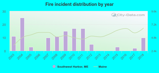
2003 - 2018 National Fire Incident Reporting System (NFIRS) incidents
Based on the data from the years 2003 - 2018 the average number of fire incidents per year is 8. The highest number of fires - 25 took place in 2004, and the least - 0 in 2006. The data has a dropping trend.
When looking into fire subcategories, the most incidents belonged to: Structure Fires (57.4%), and Outside Fires (28.7%).
Fire incident types reported to NFIRS in Southwest Harbor, ME


 Recent articles from our blog. Our writers, many of them Ph.D. graduates or candidates, create easy-to-read articles on a wide variety of topics.

 (105.8 miles


 Based on the data from the years 2003 - 2018 the average number of fire incidents per year is 8. The highest number of fires - 25 took place in 2004, and the least - 0 in 2006. The data has a dropping trend.
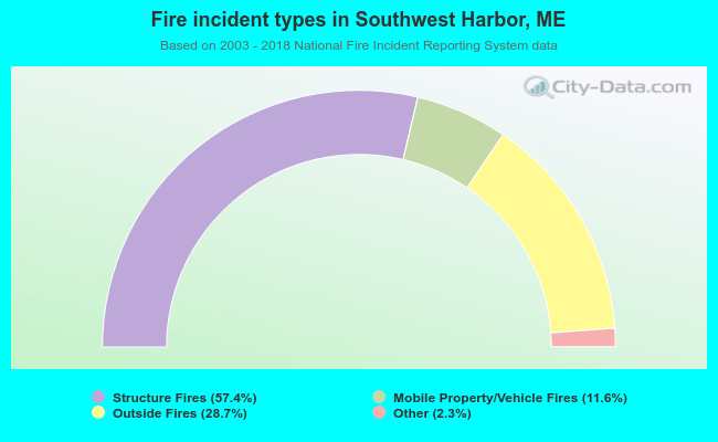 When looking into fire subcategories, the most incidents belonged to: Structure Fires (57.4%), and Outside Fires (28.7%).