Southeast Pontotoc, Oklahoma
Submit your own pictures of this place and show them to the world
- OSM Map
- General Map
- Google Map
- MSN Map

| Males: 1,158 | |
| Females: 1,240 |
| Median resident age: | 37.9 years |
| Oklahoma median age: | 35.5 years |
Zip code: 74871
| Southeast Pontotoc: | $56,441 |
| OK: | $59,673 |
Estimated per capita income in 2022: $29,139 (it was $14,180 in 2000)
Southeast Pontotoc CCD income, earnings, and wages data
Estimated median house or condo value in 2022: $124,410 (it was $42,800 in 2000)
| Southeast Pontotoc: | $124,410 |
| OK: | $191,700 |
Mean prices in 2022: all housing units: $207,584; detached houses: $218,520; townhouses or other attached units: $155,914; mobile homes: $86,598; occupied boats, rvs, vans, etc.: $5,420
Southeast Pontotoc, OK residents, houses, and apartments details
Detailed information about poverty and poor residents in Southeast Pontotoc, OK
Compare current foreclosures near Southeast Pontotoc, OK:
| Photo | Address | Area | Beds / Baths | Price | Details |
|---|---|---|---|---|---|

|
#1
Governor Harris Dr
Ada, OK 74820
|
1,592 sq. feet
|
1 baths 3 beds |
$44,900
|
show details |

|
#2
Webb Ave
Ada, OK 74820
|
1,509 sq. feet
|
1 baths 3 beds |
show details | |

|
#3
County Road 3552
Ada, OK 74820
|
1,486 sq. feet
|
1 baths 3 beds |
show details | |

|
#4
W 20th St
Ada, OK 74820
|
1,456 sq. feet
|
1 baths 3 beds |
show details | |

|
#5
S Cherry St
Ada, OK 74820
|
1,080 sq. feet
|
1 baths 2 beds |
show details | |

|
#6
S Cherry St
Ada, OK 74820
|
1,179 sq. feet
|
1 baths 2 beds |
show details | |

|
#7
County Road 1528
Ada, OK 74820
|
1,860 sq. feet
|
2 baths 3 beds |
show details | |

|
#8
Whispering Hills St
Ada, OK 74820
|
1,919 sq. feet
|
2 baths 3 beds |
show details | |

|
#9
County Road 3588
Ada, OK 74820
|
1,350 sq. feet
|
1 baths 3 beds |
show details | |

|
#10
Augusta Dr
Ada, OK 74820
|
2,449 sq. feet
|
3 baths 5 beds |
show details |
| Photo | Address | Area | Beds / Baths | Price | Details |
|---|---|---|---|---|---|

|
#11
Winchester Ave
Ada, OK 74820
|
1,850 sq. feet
|
2 baths 3 beds |
show details | |

|
#12
W 22nd St
Ada, OK 74820
|
1,910 sq. feet
|
1 baths 3 beds |
show details | |

|
#13
County Road 1575
Ada, OK 74820
|
1,233 sq. feet
|
1 baths - beds |
show details | |

|
#14
County Road 3490
Ada, OK 74820
|
- sq. feet
|
- baths - beds |
show details | |

|
#15
N Cherry St
Ada, OK 74820
|
- sq. feet
|
- baths - beds |
show details | |

|
#16
N Us Hwy 377
Connerville, OK 74836
|
- sq. feet
|
- baths - beds |
show details | |

|
#17
County Road 3490
Ada, OK 74820
|
- sq. feet
|
- baths - beds |
show details | |

|
#18
SW Powell 10119 Ct, Cr 3552
Ada, OK 74820
|
- sq. feet
|
- baths - beds |
show details | |

|
#19
S Broadway
Stonewall, OK 74871
|
- sq. feet
|
- baths - beds |
show details | |

|
#20
Stonebridge
Ada, OK 74820
|
- sq. feet
|
- baths - beds |
show details |
| Photo | Address | Area | Beds / Baths | Price | Details |
|---|---|---|---|---|---|

|
#21
County Road 1560
Ada, OK 74820
|
- sq. feet
|
- baths - beds |
show details | |

|
#22
County Road 3540
Ada, OK 74820
|
- sq. feet
|
- baths - beds |
show details | |

|
#23
Williams St
Ada, OK 74820
|
- sq. feet
|
- baths - beds |
show details | |

|
#24
County Road 1600
Stonewall, OK 74871
|
- sq. feet
|
- baths - beds |
show details | |

|
#25
County Road 1566
Ada, OK 74820
|
- sq. feet
|
- baths - beds |
show details | |

|
#26
Wolfe Ln
Ada, OK 74820
|
- sq. feet
|
- baths - beds |
show details | |

|
#27
County Road 3613
Ada, OK 74820
|
- sq. feet
|
- baths - beds |
show details | |

|
#28
W Division
Roff, OK 74865
|
- sq. feet
|
- baths - beds |
show details | |

|
Check over 1 million property listings on Foreclosure.com!
|
browse all offers | |||

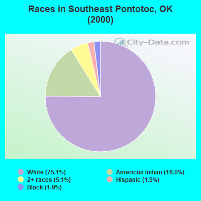
- 1,74075.1%White alone
- 37016.0%American Indian alone
- 1175.1%Two or more races
- 431.9%Black alone
- 441.9%Hispanic
- 20.09%Other race alone
Races in Southeast Pontotoc detailed stats: ancestries, foreign born residents, place of birth
 Recent articles from our blog. Our writers, many of them Ph.D. graduates or candidates, create easy-to-read articles on a wide variety of topics.
Current Local Time: CST time zone
Land area: 131.0 square miles.
Population density: 18 people per square mile (very low).

| Southeast Pontotoc CCD: | 0.5% ($199) |
| Oklahoma: | 0.8% ($523) |
Nearest city with pop. 50,000+: Norman, OK  (62.3 miles , pop. 95,694).
Nearest city with pop. 200,000+: Oklahoma City, OK (79.3 miles , pop. 506,132).
Nearest city with pop. 1,000,000+: Dallas, TX (129.5 miles , pop. 1,188,580).
Nearest cities:
), ), ), ), )Latitude: 34.66 N, Longitude: 96.56 W
Area code commonly used in this area: 580

| Here: | 3.0% |
| Oklahoma: | 3.2% |
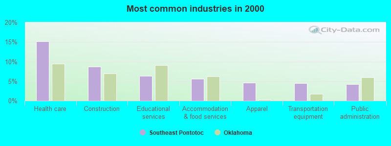
- Health care (15.1%)
- Construction (8.7%)
- Educational services (6.4%)
- Accommodation & food services (5.6%)
- Apparel (4.6%)
- Transportation equipment (4.4%)
- Public administration (4.2%)
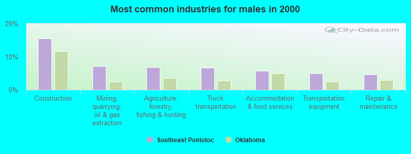
- Construction (15.5%)
- Mining, quarrying, oil & gas extraction (7.2%)
- Agriculture, forestry, fishing & hunting (6.8%)
- Truck transportation (6.6%)
- Accommodation & food services (5.7%)
- Transportation equipment (4.9%)
- Repair & maintenance (4.7%)
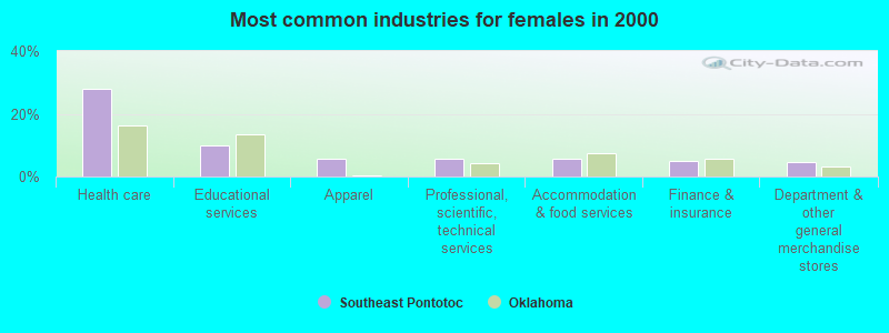
- Health care (28.1%)
- Educational services (9.8%)
- Apparel (5.7%)
- Professional, scientific, technical services (5.7%)
- Accommodation & food services (5.5%)
- Finance & insurance (4.9%)
- Department & other general merchandise stores (4.7%)

- Driver/sales workers and truck drivers (5.1%)
- Textile, apparel, and furnishings workers (5.0%)
- Other office and administrative support workers, including supervisors (3.8%)
- Building and grounds cleaning and maintenance occupations (3.8%)
- Health technologists and technicians (3.6%)
- Other management occupations, except farmers and farm managers (3.3%)
- Secretaries and administrative assistants (3.2%)
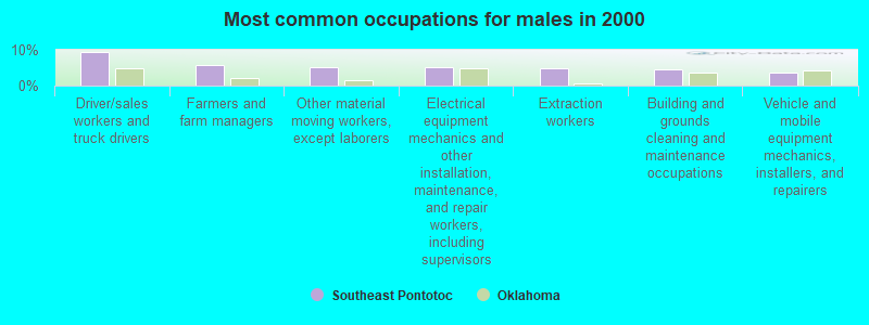
- Driver/sales workers and truck drivers (9.3%)
- Farmers and farm managers (5.7%)
- Other material moving workers, except laborers (5.3%)
- Electrical equipment mechanics and other installation, maintenance, and repair workers, including supervisors (5.1%)
- Extraction workers (4.7%)
- Building and grounds cleaning and maintenance occupations (4.5%)
- Vehicle and mobile equipment mechanics, installers, and repairers (3.8%)

- Other office and administrative support workers, including supervisors (8.0%)
- Health technologists and technicians (7.0%)
- Secretaries and administrative assistants (6.8%)
- Textile, apparel, and furnishings workers (6.6%)
- Preschool, kindergarten, elementary, and middle school teachers (5.1%)
- Cashiers (4.3%)
- Counselors, social workers, and other community and social service specialists (4.1%)
Average climate in Southeast Pontotoc, Oklahoma
Based on data reported by over 4,000 weather stations


Tornado activity:
Southeast Pontotoc-area historical tornado activity is near Oklahoma state average. It is 175% greater than the overall U.S. average.
On 5/9/1959, a category F4 (max. wind speeds 207-260 mph) tornado 2.4 miles away from the Southeast Pontotoc place center killed 7 people and injured 12 people and caused between $50,000 and $500,000 in damages.
On 4/27/1966, a category F4 tornado 23.7 miles away from the place center injured 2 people and caused between $50,000 and $500,000 in damages.
Earthquake activity:
Southeast Pontotoc-area historical earthquake activity is significantly above Oklahoma state average. It is 703% greater than the overall U.S. average.On 11/6/2011 at 03:53:10, a magnitude 5.7 (5.7 MW, Depth: 3.2 mi, Class: Moderate, Intensity: VI - VII) earthquake occurred 61.3 miles away from the city center
On 9/3/2016 at 12:02:44, a magnitude 5.8 (5.8 MW, Depth: 3.5 mi) earthquake occurred 123.7 miles away from Southeast Pontotoc center
On 11/7/2016 at 01:44:24, a magnitude 5.0 (5.0 MW, Depth: 2.8 mi) earthquake occurred 92.9 miles away from Southeast Pontotoc center
On 11/8/2011 at 02:46:57, a magnitude 4.8 (4.8 MW, Depth: 3.1 mi, Class: Light, Intensity: IV - V) earthquake occurred 61.5 miles away from the city center
On 11/5/2011 at 07:12:45, a magnitude 4.8 (4.8 MW, Depth: 1.9 mi) earthquake occurred 62.5 miles away from the city center
On 9/6/1997 at 23:38:00, a magnitude 4.5 (4.5 LG, 4.2 LG, Depth: 3.1 mi) earthquake occurred 6.9 miles away from Southeast Pontotoc center
Magnitude types: regional Lg-wave magnitude (LG), moment magnitude (MW)
Natural disasters:
The number of natural disasters in Pontotoc County (20) is greater than the US average (15).Major Disasters (Presidential) Declared: 12
Emergencies Declared: 6
Causes of natural disasters: Floods: 8, Storms: 8, Tornadoes: 8, Winter Storms: 8, Winds: 2, Fire: 1, Heavy Rain: 1, Hurricane: 1, Snow: 1, Other: 1 (Note: some incidents may be assigned to more than one category).
Hospitals and medical centers near Southeast Pontotoc:
- STONEGATE NURSING CENTER (Nursing Home, about 2 miles away; STONEWALL, OK)
- ROLLING HILLS HOSPITAL (Hospital, about 10 miles away; ADA, OK)
- JAN FRANCES CARE CENTER (Nursing Home, about 10 miles away; ADA, OK)
- ADA CARE CENTER (Nursing Home, about 10 miles away; ADA, OK)
- MAYS HOUSECALL HOME HEALTH, INC (Home Health Center, about 11 miles away; ADA, OK)
- MCCORTNEY FAMILY HOSPICE, INC (Hospital, about 11 miles away; ADA, OK)
- ADA HOME HEALTH CARE, INC (Home Health Center, about 11 miles away; ADA, OK)
Colleges/universities with over 2000 students nearest to Southeast Pontotoc:
- East Central University (about 10 miles; Ada, OK; Full-time enrollment: 4,030)
- Southeastern Oklahoma State University (about 47 miles; Durant, OK; FT enrollment: 3,365)
- University of Oklahoma-Norman Campus (about 63 miles; Norman, OK; FT enrollment: 22,496)
- Grayson College (about 67 miles; Denison, TX; FT enrollment: 2,496)
- Rose State College (about 73 miles; Midwest City, OK; FT enrollment: 4,896)
- Mid-America Christian University (about 75 miles; Oklahoma City, OK; FT enrollment: 2,869)
- Oklahoma State University Institute of Technology (about 76 miles; Okmulgee, OK; FT enrollment: 3,243)
Points of interest:
Notable locations in Southeast Pontotoc: Union Valley Volunteer Fire Department (A), Pontotoc Ridge Preserve Fire Protection (B), Stonewall Fire Department (C), Lula Volunteer Fire Department (D). Display/hide their locations on the map
Churches in Southeast Pontotoc include: Hall Hill Church (A), First Baptist Church (B), Owl Creek Church (C). Display/hide their locations on the map
Cemeteries: Jesse Cemetery (1), Frisco Cemetery (2), Highland Cemetery (3), Lula Cemetery (4), Malville Cemetery (5), Cockran Cemetery (6). Display/hide their locations on the map
Reservoirs: Miller Lake (A), Stonewall Lake (B), Leader Middle Clear Boggy Creek 17 Reservoir (C), Leader Middle Clear Boggy Creek 18 Reservoir (D), Leader Middle Clear Boggy Creek 19 Reservoir (E), Leader Middle Clear Boggy Creek 20 Reservoir (F), Leader Middle Clear Boggy Creek 21 Reservoir (G), Leader Middle Clear Boggy Creek 23 Reservoir (H). Display/hide their locations on the map
Creeks: Bully Creek (A), West Buck Creek (B), Bois d'Arc Creek (C), Jack Fork Creek (D), Sheep Creek (E), Salt Creek (F), Rhoda Creek (G), Owl Creek (H), Mill Creek (I). Display/hide their locations on the map
| This place: | 2.5 people |
| Oklahoma: | 2.5 people |
| This place: | 70.9% |
| Whole state: | 66.8% |
| This place: | 4.7% |
| Whole state: | 5.9% |
Likely homosexual households (counted as self-reported same-sex unmarried-partner households)
- Lesbian couples: 0.5% of all households
- Gay men: 0.3% of all households
| This place: | 16.5% |
| Whole state: | 14.7% |
| This place: | 5.3% |
| Whole state: | 6.1% |
For population 15 years and over in Southeast Pontotoc:
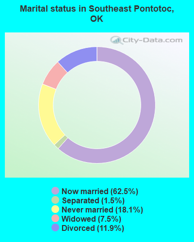
- Never married: 18.1%
- Now married: 62.5%
- Separated: 1.5%
- Widowed: 7.5%
- Divorced: 11.9%
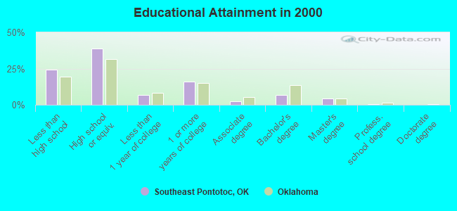
For population 25 years and over in Southeast Pontotoc:
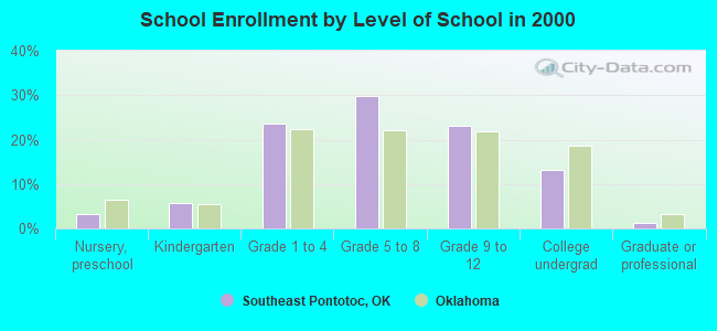
- High school or higher: 75.9%
- Bachelor's degree or higher: 12.1%
- Graduate or professional degree: 5.2%
- Unemployed: 4.8%
- Mean travel time to work (commute): 23.4 minutes
| Here: | 10.6 |
| Oklahoma average: | 11.7 |
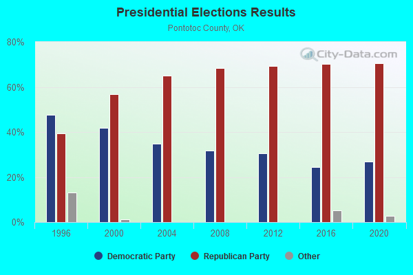
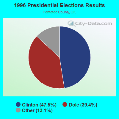
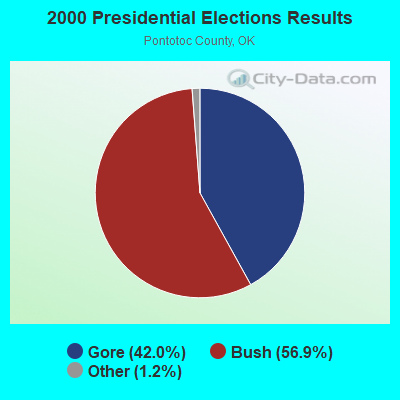


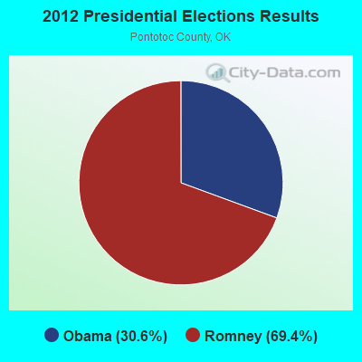
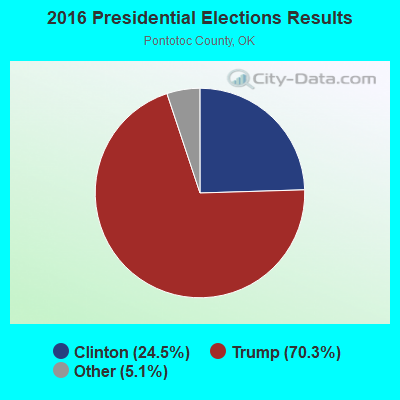

Graphs represent county-level data. Detailed 2008 Election Results
Religion statistics for Southeast Pontotoc, OK (based on Pontotoc County data)
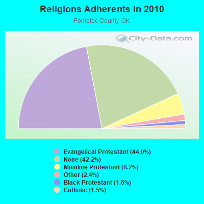
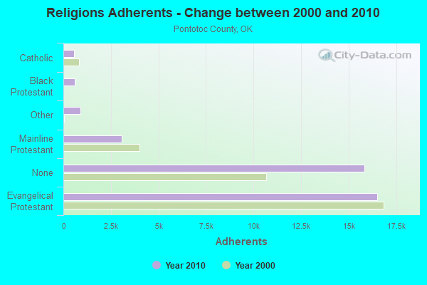
| Religion | Adherents | Congregations |
|---|---|---|
| Evangelical Protestant | 16,504 | 85 |
| Mainline Protestant | 3,076 | 11 |
| Other | 890 | 4 |
| Black Protestant | 613 | 2 |
| Catholic | 574 | 1 |
| None | 15,835 | - |
Food Environment Statistics:
| Here: | 1.10 / 10,000 pop. |
| Oklahoma: | 1.97 / 10,000 pop. |
| Here: | 0.27 / 10,000 pop. |
| Oklahoma: | 0.20 / 10,000 pop. |
| This county: | 0.55 / 10,000 pop. |
| Oklahoma: | 0.76 / 10,000 pop. |
| Here: | 4.93 / 10,000 pop. |
| State: | 4.35 / 10,000 pop. |
| This county: | 7.12 / 10,000 pop. |
| Oklahoma: | 6.89 / 10,000 pop. |
| Here: | 10.2% |
| Oklahoma: | 10.3% |
| Pontotoc County: | 31.2% |
| State: | 29.2% |
Strongest AM radio stations in Southeast Pontotoc:
- KADA (1230 AM; 1 kW; ADA, OK; Owner: THE CHICKASAW NATION)
- KOMA (1520 AM; 50 kW; OKLAHOMA CITY, OK; Owner: RENDA BROADCASTING CORP. OF NEVADA)
- KRMG (740 AM; 50 kW; TULSA, OK; Owner: CXR HOLDINGS, INC.)
- KEOR (1110 AM; daytime; 5 kW; ATOKA, OK; Owner: DALLAS AM RADIO PARTNERS, L.P.)
- KFAQ (1170 AM; 50 kW; TULSA, OK; Owner: JOURNAL BROADCAST CORPORATION)
- KRLD (1080 AM; 50 kW; DALLAS, TX; Owner: TEXAS INFINITY BROADCASTING L.P.)
- KFXR (1190 AM; 50 kW; DALLAS, TX; Owner: CLEAR CHANNEL BROADCASTING LICENSES, INC.)
- WBAP (820 AM; 50 kW; FORT WORTH, TX; Owner: WBAP-KSCS OPERATING, LTD.)
- KYNG (950 AM; 10 kW; DENISON-SHERMAN, TX; Owner: KRBE LICO, INC.)
- KESS (1270 AM; 50 kW; FORT WORTH, TX; Owner: KESS-AM LICENSE CORP.)
- KZMP (1540 AM; 50 kW; UNIVERSITY PARK, TX; Owner: ENTRAVISION HOLDINGS, LLC)
- KAHZ (1360 AM; 50 kW; HURST, TX)
- KSKY (660 AM; 20 kW; BALCH SPRINGS, TX; Owner: BISON MEDIA, INC.)
Strongest FM radio stations in Southeast Pontotoc:
- K209AZ (89.7 FM; ADA, OK; Owner: CREATIVE EDUCATIONAL MEDIA CORP. INC)
- KAZC (88.3 FM; TISHOMINGO, OK; Owner: SOUTH CENTRAL OKLAHOMA CHRISTIAN BROADCASTING, INC.)
- KADA-FM (99.3 FM; ADA, OK; Owner: THE CHICKASAW NATION)
- KQCV-FM (95.1 FM; SHAWNEE, OK; Owner: COMMUNITY BROADCASTING, INC)
- K204BX (88.7 FM; ADA, OK; Owner: AMERICAN FAMILY ASSOCIATION)
- KYKC (100.1 FM; BYNG, OK; Owner: CENTRAL OKLAHOMA COMMUNICATIONS CO.)
- KTGS (89.9 FM; ADA, OK; Owner: S CENTRAL OK CHRISTIAN BROADC/G INC)
- KIXO (106.1 FM; SULPHUR, OK; Owner: DFWU, INC.)
- KHKC-FM (102.1 FM; ATOKA, OK; Owner: KEYSTONE BROADCASTING CORPORATION)
- KSLE (104.7 FM; WEWOKA, OK; Owner: ONE TEN BROADCASTING GROUP, INC.)
TV broadcast stations around Southeast Pontotoc:
- KTEN (Channel 10; ADA, OK; Owner: CHANNEL 49 ACQUISITION CORPORATION)
- K35CU (Channel 35; ADA, OK; Owner: LOCKE SUPPLY CO.)
- KXII (Channel 12; SHERMAN, TX; Owner: KXII LICENSEE CORP.)
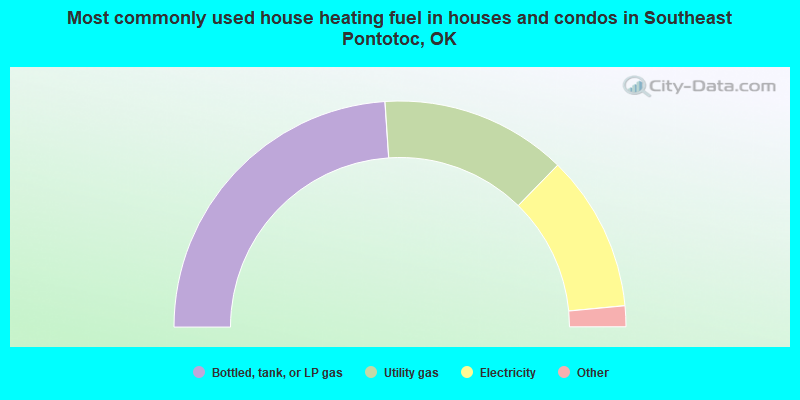
- 47.9%Bottled, tank, or LP gas
- 26.7%Utility gas
- 22.4%Electricity
- 2.7%Wood
- 0.3%Other fuel
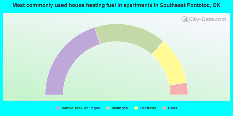
- 40.1%Bottled, tank, or LP gas
- 32.7%Utility gas
- 21.6%Electricity
- 3.1%Wood
- 2.5%Other fuel
Southeast Pontotoc compared to Oklahoma state average:
- Median house value below state average.
- Unemployed percentage significantly below state average.
- Black race population percentage significantly below state average.
- Hispanic race population percentage significantly below state average.
- Foreign-born population percentage significantly below state average.
- Renting percentage below state average.
- Length of stay since moving in significantly above state average.
- Number of rooms per house significantly below state average.
- House age significantly below state average.
- Percentage of population with a bachelor's degree or higher below state average.