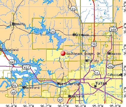
Southeast Osage, Oklahoma
Submit your own pictures of this place and show them to the world
- OSM Map
- General Map
- Google Map
- MSN Map
| Males: 10,245 | |
| Females: 10,605 |
| Median resident age: | 37.0 years |
| Oklahoma median age: | 35.5 years |
Zip code: 74073
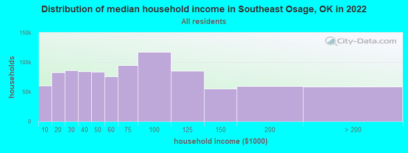
| Southeast Osage: | $67,887 |
| OK: | $59,673 |
Estimated per capita income in 2022: $32,178 (it was $18,696 in 2000)
Southeast Osage CCD income, earnings, and wages data
Estimated median house or condo value in 2022: $221,698 (it was $77,500 in 2000)
| Southeast Osage: | $221,698 |
| OK: | $191,700 |
Mean prices in 2022: all housing units: $218,021; detached houses: $234,628; townhouses or other attached units: $326,732; mobile homes: $109,203; occupied boats, rvs, vans, etc.: $26,836
Southeast Osage, OK residents, houses, and apartments details
Detailed information about poverty and poor residents in Southeast Osage, OK
Compare current foreclosures near Southeast Osage, OK:
| Photo | Address | Area | Beds / Baths | Price | Details |
|---|---|---|---|---|---|

|
#1
N 100th West Ave
Skiatook, OK 74070
|
1,680 sq. feet
|
2 baths 3 beds |
show details | |

|
#2
S Seminole St
Skiatook, OK 74070
|
1,694 sq. feet
|
2 baths 4 beds |
show details | |

|
#3
E Newton St
Tulsa, OK 74115
|
1,308 sq. feet
|
1 baths 3 beds |
show details | |

|
#4
Howard St
Sand Springs, OK 74063
|
1,774 sq. feet
|
2 baths 3 beds |
show details | |

|
#5
N Evanston Ave
Tulsa, OK 74110
|
- sq. feet
|
- baths - beds |
$29,900
|
show details |

|
#6
S 27th West Ave
Tulsa, OK 74107
|
1,202 sq. feet
|
1 baths 3 beds |
show details | |

|
#7
E 24th Pl
Tulsa, OK 74114
|
1,036 sq. feet
|
1 baths 2 beds |
show details | |

|
#8
W Easton St
Tulsa, OK 74127
|
1,395 sq. feet
|
2 baths 4 beds |
show details | |

|
#9
E 78th St N
Owasso, OK 74055
|
1,340 sq. feet
|
2 baths 3 beds |
show details | |

|
#10
S 45th West Ave
Tulsa, OK 74127
|
1,176 sq. feet
|
1 baths 3 beds |
show details |
| Photo | Address | Area | Beds / Baths | Price | Details |
|---|---|---|---|---|---|

|
#11
S Louisville Ave
Tulsa, OK 74135
|
939 sq. feet
|
1 baths 2 beds |
show details | |

|
#12
W Independence Pl
Tulsa, OK 74127
|
2,020 sq. feet
|
2 baths 3 beds |
show details | |

|
#13
E Zion St
Tulsa, OK 74106
|
1,247 sq. feet
|
1 baths 4 beds |
show details | |

|
#14
S 107th East Ave
Tulsa, OK 74128
|
1,022 sq. feet
|
1 baths 2 beds |
show details | |

|
#15
E Archer St
Tulsa, OK 74115
|
- sq. feet
|
- baths - beds |
$26,900
|
show details |

|
#16
99th East Ave
Tulsa, OK 74129
|
2,358 sq. feet
|
2 baths 4 beds |
show details | |

|
#17
N Frankfort Pl
Tulsa, OK 74126
|
1,348 sq. feet
|
1 baths 2 beds |
show details | |

|
#18
W Evergreen St
Skiatook, OK 74070
|
1,914 sq. feet
|
2 baths 3 beds |
show details | |

|
#19
W Oklahoma Pl
Tulsa, OK 74127
|
1,595 sq. feet
|
2 baths 3 beds |
show details | |

|
#20
N Union Pl
Tulsa, OK 74127
|
1,477 sq. feet
|
2 baths 3 beds |
show details |
| Photo | Address | Area | Beds / Baths | Price | Details |
|---|---|---|---|---|---|

|
#21
W Haskell Pl
Tulsa, OK 74127
|
1,791 sq. feet
|
2 baths 3 beds |
show details | |

|
#22
Meadow Ln
Mannford, OK 74044
|
1,536 sq. feet
|
3 baths 3 beds |
show details | |

|
#23
N 194th West Ave
Sand Springs, OK 74063
|
1,680 sq. feet
|
2 baths 3 beds |
show details | |

|
#24
Goldenrod Ln
Sand Springs, OK 74063
|
1,557 sq. feet
|
2 baths 3 beds |
show details | |

|
#25
E 26th Pl N
Tulsa, OK 74110
|
952 sq. feet
|
1 baths - beds |
show details | |

|
#26
W Xyler St
Tulsa, OK 74127
|
1,947 sq. feet
|
2 baths 4 beds |
show details | |

|
#27
Osage Pass
Sand Springs, OK 74063
|
1,216 sq. feet
|
2 baths 4 beds |
show details | |

|
#28
W 4000 Rd
Skiatook, OK 74070
|
2,242 sq. feet
|
1 baths 3 beds |
show details | |

|
#29
N 152nd East Ave
Collinsville, OK 74021
|
1,480 sq. feet
|
2 baths 3 beds |
show details | |

|
#30
N 50th West Ave
Sperry, OK 74073
|
1,820 sq. feet
|
3 baths 6 beds |
show details |
| Photo | Address | Area | Beds / Baths | Price | Details |
|---|---|---|---|---|---|

|
#31
W 12th St
Sand Springs, OK 74063
|
2,083 sq. feet
|
2 baths - beds |
show details | |

|
#32
W Virgin St
Tulsa, OK 74127
|
2,190 sq. feet
|
2 baths 4 beds |
show details | |

|
#33
W Haskell Pl
Tulsa, OK 74127
|
1,368 sq. feet
|
1 baths 2 beds |
show details | |

|
#34
S Javine Ct
Skiatook, OK 74070
|
1,570 sq. feet
|
2 baths 3 beds |
show details | |

|
#35
N Woodview Dr
Skiatook, OK 74070
|
1,786 sq. feet
|
1 baths 3 beds |
show details | |

|
#36
W Elm St
Skiatook, OK 74070
|
1,456 sq. feet
|
3 baths 3 beds |
show details | |

|
#37
W 49th Pl
Tulsa, OK 74107
|
1,032 sq. feet
|
1 baths - beds |
show details | |

|
#38
S 94th East Ave
Tulsa, OK 74129
|
1,713 sq. feet
|
2 baths - beds |
show details | |

|
#39
S Canton Ave
Tulsa, OK 74112
|
1,230 sq. feet
|
1 baths - beds |
show details | |

|
#40
S Yorktown Ave
Tulsa, OK 74136
|
1,280 sq. feet
|
2 baths - beds |
show details |
| Photo | Address | Area | Beds / Baths | Price | Details |
|---|---|---|---|---|---|

|
#41
E 56th Pl
Tulsa, OK 74105
|
3,697 sq. feet
|
3 baths - beds |
show details | |

|
#42
N 144th East Ave
Owasso, OK 74055
|
1,358 sq. feet
|
2 baths - beds |
show details | |

|
#43
S Darlington Ave
Tulsa, OK 74112
|
920 sq. feet
|
1 baths - beds |
show details | |

|
#44
S Waco Ave
Tulsa, OK 74107
|
1,666 sq. feet
|
1 baths - beds |
show details | |

|
#45
E 112th Pl N
Owasso, OK 74055
|
1,312 sq. feet
|
1 baths - beds |
show details | |

|
#46
S 81st West Ave
Tulsa, OK 74107
|
1,022 sq. feet
|
1 baths - beds |
show details | |

|
#47
S Nogales Ave
Tulsa, OK 74107
|
1,066 sq. feet
|
1 baths - beds |
show details | |

|
#48
W 10th St
Owasso, OK 74055
|
1,378 sq. feet
|
2 baths - beds |
show details | |

|
#49
S 263rd West Ave
Sand Springs, OK 74063
|
2,076 sq. feet
|
2 baths - beds |
show details | |

|
Check over 1 million property listings on Foreclosure.com!
|
browse all offers | |||

- 12,60761.4%White alone
- 4,14820.2%Black alone
- 2,0029.8%American Indian alone
- 1,2746.2%Two or more races
- 4362.1%Hispanic
- 350.2%Asian alone
- 100.05%Other race alone
- 90.04%Native Hawaiian and Other
Pacific Islander alone
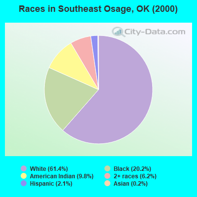
Races in Southeast Osage detailed stats: ancestries, foreign born residents, place of birth
 Recent articles from our blog. Our writers, many of them Ph.D. graduates or candidates, create easy-to-read articles on a wide variety of topics.
Current Local Time: CST time zone
Land area: 239.0 square miles.
Population density: 87 people per square mile (very low).

| Southeast Osage CCD: | 0.7% ($545) |
| Oklahoma: | 0.8% ($523) |
Nearest city with pop. 50,000+: Tulsa, OK  (13.9 miles , pop. 393,049).
Nearest city with pop. 1,000,000+: Dallas, TX (243.9 miles , pop. 1,188,580).
Nearest cities:
), ), Latitude: 36.28 N, Longitude: 96.10 W
Area code commonly used in this area: 918

| Here: | 3.9% |
| Oklahoma: | 3.2% |
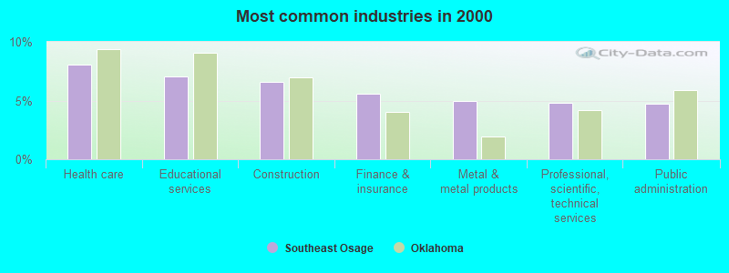
- Health care (8.1%)
- Educational services (7.0%)
- Construction (6.6%)
- Finance & insurance (5.5%)
- Metal & metal products (5.0%)
- Professional, scientific, technical services (4.8%)
- Public administration (4.7%)
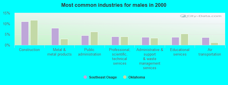
- Construction (11.0%)
- Metal & metal products (8.0%)
- Public administration (4.5%)
- Professional, scientific, technical services (4.0%)
- Administrative & support & waste management services (3.7%)
- Educational services (3.7%)
- Air transportation (3.6%)
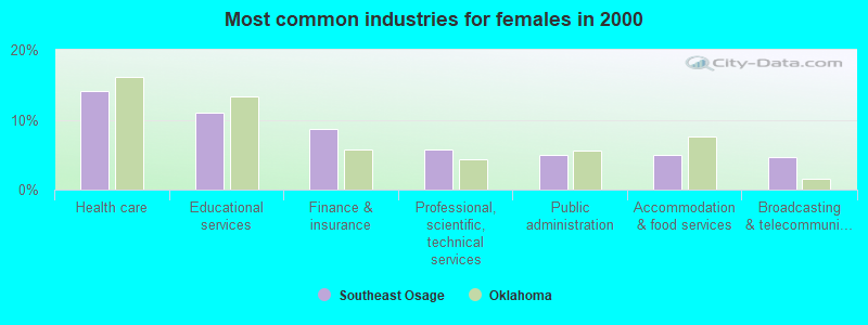
- Health care (14.1%)
- Educational services (11.0%)
- Finance & insurance (8.6%)
- Professional, scientific, technical services (5.7%)
- Public administration (5.0%)
- Accommodation & food services (5.0%)
- Broadcasting & telecommunications (4.7%)
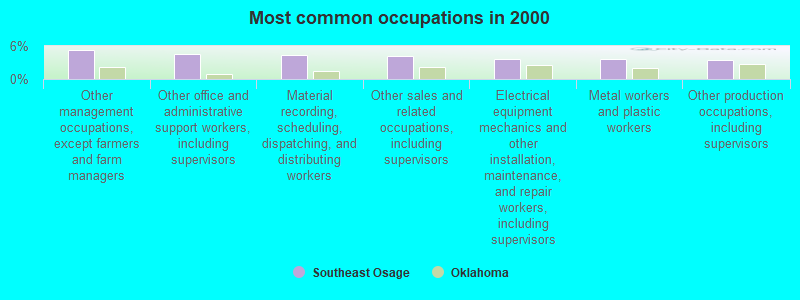
- Other management occupations, except farmers and farm managers (5.3%)
- Other office and administrative support workers, including supervisors (4.5%)
- Material recording, scheduling, dispatching, and distributing workers (4.4%)
- Other sales and related occupations, including supervisors (4.3%)
- Electrical equipment mechanics and other installation, maintenance, and repair workers, including supervisors (3.7%)
- Metal workers and plastic workers (3.6%)
- Other production occupations, including supervisors (3.4%)
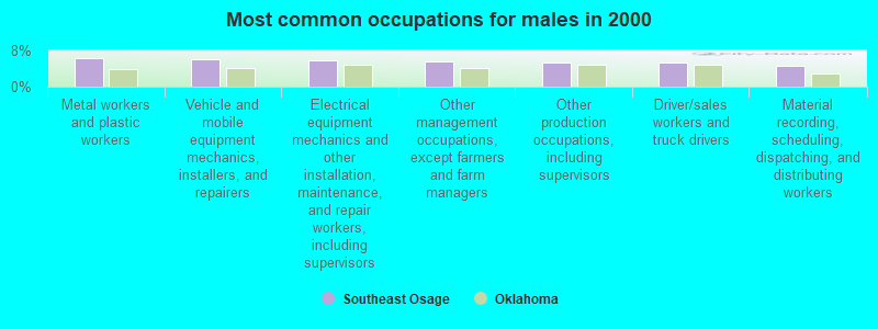
- Metal workers and plastic workers (6.4%)
- Vehicle and mobile equipment mechanics, installers, and repairers (6.0%)
- Electrical equipment mechanics and other installation, maintenance, and repair workers, including supervisors (5.9%)
- Other management occupations, except farmers and farm managers (5.5%)
- Other production occupations, including supervisors (5.4%)
- Driver/sales workers and truck drivers (5.4%)
- Material recording, scheduling, dispatching, and distributing workers (4.7%)

- Other office and administrative support workers, including supervisors (7.7%)
- Secretaries and administrative assistants (6.2%)
- Other sales and related occupations, including supervisors (5.7%)
- Other management occupations, except farmers and farm managers (5.1%)
- Information and record clerks, except customer service representatives (4.9%)
- Material recording, scheduling, dispatching, and distributing workers (4.1%)
- Preschool, kindergarten, elementary, and middle school teachers (3.9%)
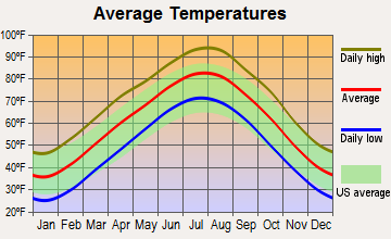
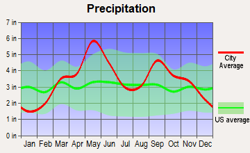
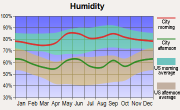
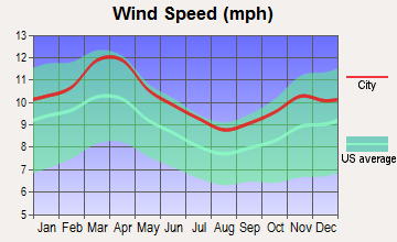
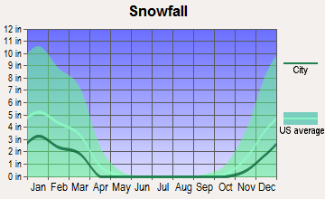
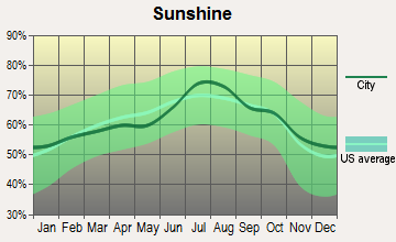
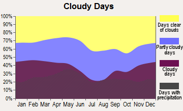
Average climate in Southeast Osage, Oklahoma
Based on data reported by over 4,000 weather stations
(lower is better)
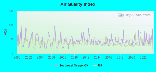
Air Quality Index (AQI) level in 2023 was 110. This is significantly worse than average.
| City: | 110 |
| U.S.: | 73 |
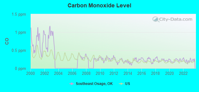
Carbon Monoxide (CO) [ppm] level in 2023 was 0.231. This is about average. Closest monitor was 8.8 miles away from the city center.
| City: | 0.231 |
| U.S.: | 0.251 |
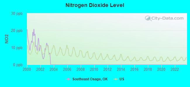
Nitrogen Dioxide (NO2) [ppb] level in 2002 was 7.79. This is significantly worse than average. Closest monitor was 5.4 miles away from the city center.
| City: | 7.79 |
| U.S.: | 5.11 |
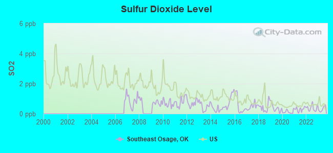
Sulfur Dioxide (SO2) [ppb] level in 2023 was 0.320. This is significantly better than average. Closest monitor was 7.8 miles away from the city center.
| City: | 0.320 |
| U.S.: | 1.515 |
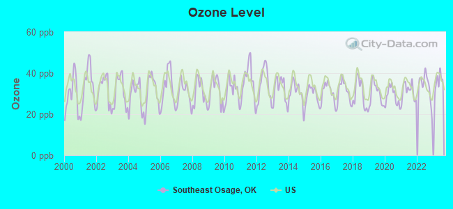
Ozone [ppb] level in 2023 was 35.7. This is about average. Closest monitor was 5.4 miles away from the city center.
| City: | 35.7 |
| U.S.: | 33.3 |
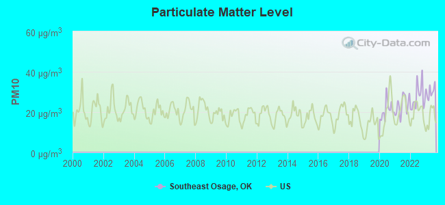
Particulate Matter (PM10) [µg/m3] level in 2023 was 30.2. This is significantly worse than average. Closest monitor was 8.8 miles away from the city center.
| City: | 30.2 |
| U.S.: | 19.2 |
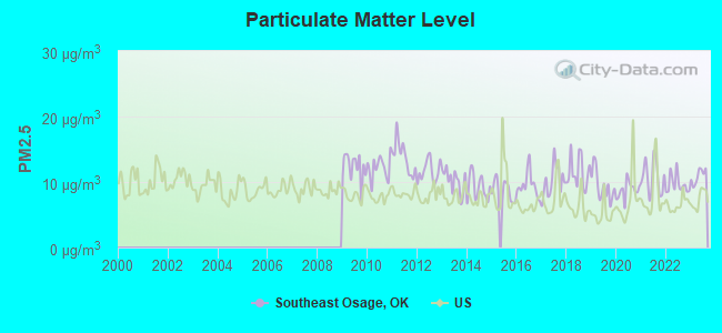
Particulate Matter (PM2.5) [µg/m3] level in 2023 was 10.9. This is worse than average. Closest monitor was 8.8 miles away from the city center.
| City: | 10.9 |
| U.S.: | 8.1 |
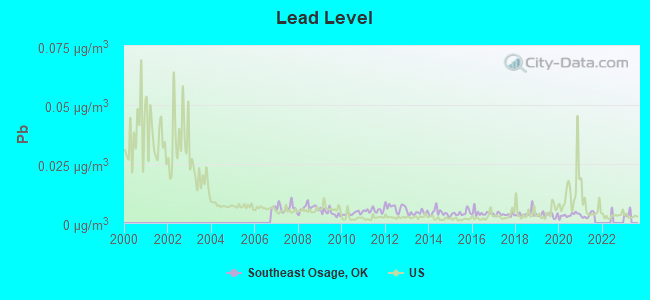
Lead (Pb) [µg/m3] level in 2021 was 0.00329. This is significantly better than average. Closest monitor was 8.4 miles away from the city center.
| City: | 0.00329 |
| U.S.: | 0.00931 |
Tornado activity:
Southeast Osage-area historical tornado activity is near Oklahoma state average. It is 172% greater than the overall U.S. average.
On 5/5/1960, a category F5 (max. wind speeds 261-318 mph) tornado 16.1 miles away from the Southeast Osage place center killed 5 people and injured 81 people and caused between $500,000 and $5,000,000 in damages.
On 4/29/1984, a category F4 (max. wind speeds 207-260 mph) tornado 5.5 miles away from the place center killed one person and injured 60 people and caused between $5,000,000 and $50,000,000 in damages.
Earthquake activity:
Southeast Osage-area historical earthquake activity is significantly above Oklahoma state average. It is 822% greater than the overall U.S. average.On 9/3/2016 at 12:02:44, a magnitude 5.8 (5.8 MW, Depth: 3.5 mi, Class: Moderate, Intensity: VI - VII) earthquake occurred 47.1 miles away from Southeast Osage center
On 11/6/2011 at 03:53:10, a magnitude 5.7 (5.7 MW, Depth: 3.2 mi) earthquake occurred 63.7 miles away from the city center
On 11/7/2016 at 01:44:24, a magnitude 5.0 (5.0 MW, Depth: 2.8 mi) earthquake occurred 44.0 miles away from the city center
On 11/5/2011 at 07:12:45, a magnitude 4.8 (4.8 MW, Depth: 1.9 mi, Class: Light, Intensity: IV - V) earthquake occurred 62.7 miles away from the city center
On 11/8/2011 at 02:46:57, a magnitude 4.8 (4.8 MW, Depth: 3.1 mi) earthquake occurred 64.5 miles away from the city center
On 2/13/2016 at 17:07:06, a magnitude 5.1 (5.1 MW, Depth: 5.2 mi) earthquake occurred 145.8 miles away from the city center
Magnitude types: moment magnitude (MW)
Natural disasters:
The number of natural disasters in Osage County (35) is a lot greater than the US average (15).Major Disasters (Presidential) Declared: 25
Emergencies Declared: 5
Causes of natural disasters: Floods: 16, Storms: 16, Tornadoes: 11, Winter Storms: 10, Winds: 4, Fires: 3, Heavy Rains: 2, Ice Storms: 2, Hurricane: 1, Snowstorm: 1, Other: 1 (Note: some incidents may be assigned to more than one category).
Hospitals and medical centers near Southeast Osage:
- SKIATOOK NURSING HOME,LLC (Nursing Home, about 8 miles away; SKIATOOK, OK)
- SAND SPRINGS NURSING AND REHAB CENTER (Nursing Home, about 10 miles away; SAND SPRINGS, OK)
- REST HAVEN NURSING CENTER (Nursing Home, about 10 miles away; TULSA, OK)
- FMCNA - NORTH TULSA (Dialysis Facility, about 10 miles away; TULSA, OK)
- SENIOR WORLD HOSPICE (Hospital, about 10 miles away; TULSA, OK)
- COUNTRY MANOR (Nursing Home, about 10 miles away; TULSA, OK)
- INNOVATIVE SENIOR CARE HOME HEALTH (Home Health Center, about 10 miles away; SAND SPRINGS, OK)
Colleges/universities with over 2000 students nearest to Southeast Osage:
- University of Tulsa (about 13 miles; Tulsa, OK; Full-time enrollment: 3,702)
- Tulsa Community College (about 17 miles; Tulsa, OK; FT enrollment: 12,480)
- Oral Roberts University (about 18 miles; Tulsa, OK; FT enrollment: 3,216)
- Rogers State University (about 27 miles; Claremore, OK; FT enrollment: 3,482)
- Oklahoma State University Institute of Technology (about 47 miles; Okmulgee, OK; FT enrollment: 3,243)
- Oklahoma State University-Main Campus (about 56 miles; Stillwater, OK; FT enrollment: 21,700)
- Northeastern State University (about 69 miles; Tahlequah, OK; FT enrollment: 6,895)
Points of interest:
Notable locations in Southeast Osage: Dripping Spring (A), Osage School (B), Arrowhead Ranch (C), Triple M Ranch (D), Osage Hills Country Club (E), Tulsa Country Club (F), Green Country Fire and Rescue (G), Country Corner Fire District (H), Tulsa Fire Department Station 2 (I), Osage Hills Volunteer Fire Department (J), Rock Fire Department Station 2 (K), Skiatook Fire Department Station 2 (L), Black Dog Fire Association (M), Morgans Corner Volunteer Fire Department (N), Rock Fire Department (O), Zink Fire Department (P), Prue Volunteer Fire Department (Q). Display/hide their locations on the map
Shopping Center: Osage Hills Shopping Center (1). Display/hide its location on the map
Churches in Southeast Osage include: Delaware Church (A), Immaculate Conception Church (B), Lawnwood Free Will Baptist Church (C), Osage Hills Christian Church (D), Valley View Church (E), Copernaum Missionary Baptist Church (F), Calvary Temple Assembly of God (G), Calvary Heights Temple Church (H), Skiatook First Assembly of God (I). Display/hide their locations on the map
Cemeteries: Hellard Cemetery (1), Captain Cemetery (2), Osage Gardens Cemetery (3), Prairie View Cemetery (4), Sperry Rest Haven Cemetery (5). Display/hide their locations on the map
Reservoirs: Oknoname 113001 Reservoir (A), Skiatook Lake (B), Theisen Lake (C), Oknoname 113070 Reservoir (D), Oknoname 113069 Reservoir (E), Oknoname 113068 Reservoir (F), Oknoname 113067 Reservoir (G), Oknoname 113004 Reservoir (H). Display/hide their locations on the map
Creeks: Bull Creek (A), Dad Creek (B), Boggy Creek (C), Walnut Creek (D), Battle Creek (E), Tall Chief Creek (F), Cedar Creek (G), Quapaw Creek (H), Mud Creek (I). Display/hide their locations on the map
| This place: | 2.6 people |
| Oklahoma: | 2.5 people |
| This place: | 73.3% |
| Whole state: | 66.8% |
| This place: | 5.3% |
| Whole state: | 5.9% |
Likely homosexual households (counted as self-reported same-sex unmarried-partner households)
- Lesbian couples: 0.5% of all households
- Gay men: 0.5% of all households
| This place: | 10.1% |
| Whole state: | 14.7% |
| This place: | 4.5% |
| Whole state: | 6.1% |
People in group quarters in Southeast Osage in 2010:
- 43 people in nursing facilities/skilled-nursing facilities
- 29 people in emergency and transitional shelters (with sleeping facilities) for people experiencing homelessness
- 3 people in other noninstitutional facilities
21 people in residential treatment centers for emotionally disturbed children in 2000
For population 15 years and over in Southeast Osage:
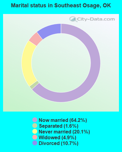
- Never married: 20.1%
- Now married: 64.2%
- Separated: 1.6%
- Widowed: 4.9%
- Divorced: 10.7%
For population 25 years and over in Southeast Osage:
- High school or higher: 84.1%
- Bachelor's degree or higher: 18.1%
- Graduate or professional degree: 5.8%
- Unemployed: 5.3%
- Mean travel time to work (commute): 24.9 minutes
| Here: | 10.7 |
| Oklahoma average: | 11.7 |
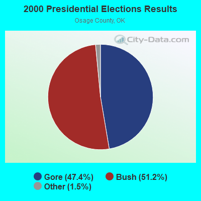
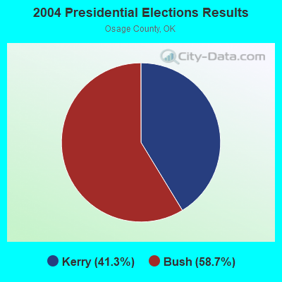
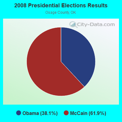
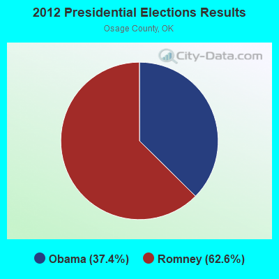
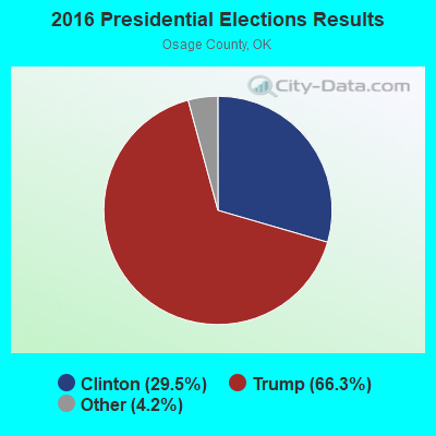
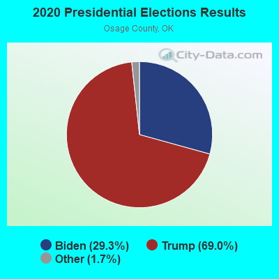
Graphs represent county-level data. Detailed 2008 Election Results
Religion statistics for Southeast Osage, OK (based on Osage County data)
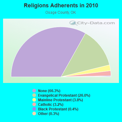
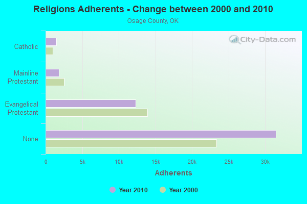
| Religion | Adherents | Congregations |
|---|---|---|
| Evangelical Protestant | 12,337 | 54 |
| Mainline Protestant | 1,783 | 15 |
| Catholic | 1,500 | 7 |
| Black Protestant | 209 | 2 |
| Other | 150 | 2 |
| None | 31,493 | - |
Food Environment Statistics:
| Osage County: | 0.66 / 10,000 pop. |
| Oklahoma: | 1.97 / 10,000 pop. |
| This county: | 0.88 / 10,000 pop. |
| Oklahoma: | 0.76 / 10,000 pop. |
| Osage County: | 4.40 / 10,000 pop. |
| State: | 4.35 / 10,000 pop. |
| Osage County: | 4.62 / 10,000 pop. |
| Oklahoma: | 6.89 / 10,000 pop. |
| Here: | 11.2% |
| Oklahoma: | 10.3% |
| Here: | 31.3% |
| Oklahoma: | 29.2% |
Strongest AM radio stations in Southeast Osage:
- KMUS (1380 AM; 20 kW; MUSKOGEE, OK; Owner: ABC, INC.)
- KRMG (740 AM; 50 kW; TULSA, OK; Owner: CXR HOLDINGS, INC.)
- KTBZ (1430 AM; 25 kW; TULSA, OK; Owner: CLEAR CHANNEL BROADCASTING LICENSES, INC.)
- KFAQ (1170 AM; 50 kW; TULSA, OK; Owner: JOURNAL BROADCAST CORPORATION)
- KCFO (970 AM; 2 kW; TULSA, OK; Owner: FRIENDSHIP BROADCASTING, L. P.)
- KGTO (1050 AM; 1 kW; TULSA, OK; Owner: KJMM, INC.)
- KAKC (1300 AM; 5 kW; TULSA, OK; Owner: CLEAR CHANNEL BROADCASTING LICENSES, INC.)
- KTFX (1340 AM; 1 kW; SAND SPRINGS, OK; Owner: K95.5, INC.)
- KYAL (1550 AM; 2 kW; SAPULPA, OK; Owner: KXOJ, INC.)
- KOMA (1520 AM; 50 kW; OKLAHOMA CITY, OK; Owner: RENDA BROADCASTING CORP. OF NEVADA)
- KGGF (690 AM; 10 kW; COFFEYVILLE, KS; Owner: KGGF-KUSN, INC.)
- KXTD (1530 AM; daytime; 5 kW; WAGONER, OK; Owner: GAYTAN-GALVAN LIMITED LIABILITY COMP)
- WHB (810 AM; 50 kW; KANSAS CITY, MO; Owner: UNION BROADCASTING, INC.)
Strongest FM radio stations in Southeast Osage:
- KMOD-FM (97.5 FM; TULSA, OK; Owner: CLEAR CHANNEL BROADCASTING LICENSES, INC.)
- KRAV-FM (96.5 FM; TULSA, OK; Owner: CXR HOLDINGS, INC.)
- KWEN (95.5 FM; TULSA, OK; Owner: CXR HOLDINGS, INC.)
- KBEZ (92.9 FM; TULSA, OK; Owner: RENDA BROADCASTING CORP. OF NEVADA)
- KVOO-FM (98.5 FM; TULSA, OK; Owner: JOURNAL BROADCAST CORPORATION)
- KRTQ (102.3 FM; SAND SPRINGS, OK; Owner: CXR HOLDINGS, INC.)
- KIZS (92.1 FM; BROKEN ARROW, OK; Owner: CLEAR CHANNEL BROADCASTING LICENSES, INC.)
- KNYD (90.5 FM; BROKEN ARROW, OK; Owner: CREATIVE EDUCATIONAL MEDIA CORP. INC)
- KQLL-FM (106.1 FM; OWASSO, OK; Owner: CLEAR CHANNEL BROADCASTING LICENSES, INC.)
- KTBT (101.5 FM; COLLINSVILLE, OK; Owner: CLEAR CHANNEL BROADCASTING LICENSES, INC.)
- KJMM (105.3 FM; BIXBY, OK; Owner: KJMM, INC.)
- KJSR (103.3 FM; TULSA, OK; Owner: CXR HOLDINGS, INC.)
- KMYZ-FM (104.5 FM; PRYOR, OK; Owner: SHAMROCK COMMUNICATIONS, INC.)
- KWGS (89.5 FM; TULSA, OK; Owner: THE UNIVERSITY OF TULSA)
- KXBL (99.5 FM; HENRYETTA, OK; Owner: JOURNAL BROADCAST CORPORATION)
- KXOJ-FM (100.9 FM; SAPULPA, OK; Owner: KXOJ, INC.)
- KHTT (106.9 FM; MUSKOGEE, OK; Owner: RENDA BROADCASTING CORP. OF NEVADA)
- KTSO (94.1 FM; OKMULGEE, OK; Owner: SHAMROCK COMMUNICATIONS, INC)
- KYFM (100.1 FM; BARTLESVILLE, OK; Owner: KCD ENTERPRISES, INC.)
- KRSC-FM (91.3 FM; CLAREMORE, OK; Owner: BOARD OF REGENTS OF OKLAHOMA COLLEGES)
TV broadcast stations around Southeast Osage:
- KLOT-LP (Channel 25; TULSA, OK; Owner: EQUITY BROADCASTING CORPORATION)
- K39CW (Channel 39; TULSA, OK; Owner: VENTANA TELEVISION, INC.)
- KTZT-LP (Channel 29; TULSA, OK; Owner: ARACELIS ORTIZ, EXECUTRIX OF THE ESTATE OF CARLOS ORTIZ)
- KOPE-LP (Channel 51; TULSA, OK; Owner: COPELAND BROADCASTING CORPORATION)
- KJRH (Channel 2; TULSA, OK; Owner: SCRIPPS HOWARD BROADCASTING COMPANY)
- KOED-TV (Channel 11; TULSA, OK; Owner: OKLAHOMA EDUCATIONAL TELEVISION AUTHORITY)
- KOTV (Channel 6; TULSA, OK; Owner: GRIFFIN LICENSING, L.L.C.)
- K33EK (Channel 33; TULSA, OK; Owner: LOCKE SUPPLY CO.)
- KTUL (Channel 8; TULSA, OK; Owner: KTUL, LLC)
- KWHB (Channel 47; TULSA, OK; Owner: LESEA BROADCASTING CORPORATION)
- KDOR (Channel 17; BARTLESVILLE, OK; Owner: TRINITY BROADCASTING NETWORK)
- KTFO (Channel 41; TULSA, OK; Owner: CLEAR CHANNEL BROADCASTING LICENSES, INC.)
- KGEB (Channel 53; TULSA, OK; Owner: UNIVERSITY BROADCASTING, INC.)
- KOKI-TV (Channel 23; TULSA, OK; Owner: CLEAR CHANNEL BROADCASTING LICENSES, INC.)
- KTPX (Channel 44; OKMULGEE, OK; Owner: PAXSON TULSA LICENSE, INC.)
- KRSC-TV (Channel 35; CLAREMORE, OK; Owner: BOARD OF REGENTS OF OKLAHOMA COLLEGES)
- K69GO (Channel 69; TULSA, OK; Owner: THREE ANGELS BROADCASTING NETWORK)
- K04NZ (Channel 4; TULSA, OK; Owner: GERALD BROTHERS)
- K15DA (Channel 15; TULSA, OK; Owner: LOCKE SUPPLY CO.)
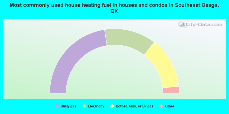
- 45.1%Utility gas
- 25.9%Electricity
- 25.7%Bottled, tank, or LP gas
- 2.7%Wood
- 0.6%Other fuel
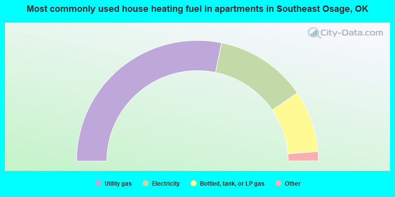
- 56.4%Utility gas
- 24.5%Electricity
- 16.6%Bottled, tank, or LP gas
- 1.7%Wood
- 0.7%No fuel used
- 0.2%Other fuel
Southeast Osage compared to Oklahoma state average:
- Unemployed percentage below state average.
- Black race population percentage significantly above state average.
- Hispanic race population percentage significantly below state average.
- Foreign-born population percentage significantly below state average.
- Renting percentage below state average.
- Length of stay since moving in significantly above state average.
- Number of rooms per house significantly below state average.
- House age significantly below state average.
Southeast Osage on our top lists:
- #7 on the list of "Top 101 cities with the smallest racial income disparities between White and Black householders (with at least 2,000 householders)"
- #9 on the list of "Top 101 cities with largest percentage of females in industries: broadcasting and telecommunications (population 5,000+)"
- #10 on the list of "Top 101 cities with largest percentage of males in industries: broadcasting, internet publishing, and telecommunications services (population 5,000+)"
- #10 on the list of "Top 101 cities with largest percentage of females in industries: broadcasting, internet publishing, and telecommunications services (population 5,000+)"
- #10 on the list of "Top 101 cities with largest percentage of males in industries: wholesale electronic markets and agents and brokers (population 5,000+)"
- #10 on the list of "Top 101 cities with largest percentage of females in industries: wholesale electronic markets and agents and brokers (population 5,000+)"
- #17 on the list of "Top 101 cities with largest percentage of males in industries: air transportation (population 5,000+)"
- #23 on the list of "Top 101 cities with largest percentage of females in occupations: accountants and auditors (population 5,000+)"
- #34 on the list of "Top 101 cities with largest percentage of females in occupations: rail and water transportation workers (population 5,000+)"
- #44 on the list of "Top 101 cities with largest percentage of females in industries: petroleum and coal products (population 5,000+)"
- #45 on the list of "Top 101 cities with largest percentage of males in industries: metal and metal products (population 5,000+)"
- #56 on the list of "Top 101 cities with the smallest racial income disparities between White and Black householders (with at least 200 householders)"
- #64 on the list of "Top 101 cities with largest percentage of females in industries: other direct selling establishments (population 5,000+)"
- #68 on the list of "Top 101 cities with largest percentage of females in industries: machinery, equipment, and supplies merchant wholesalers (population 5,000+)"
- #73 on the list of "Top 101 cities with largest percentage of females in occupations: supervisors of construction and extraction workers (population 5,000+)"
- #74 on the list of "Top 101 cities with largest percentage of females in industries: air transportation (population 5,000+)"
- #79 on the list of "Top 101 cities with largest percentage of females in industries: other transportation, and support activities, and couriers (population 5,000+)"
- #83 on the list of "Top 101 cities with largest percentage of males in occupations: vehicle and mobile equipment mechanics, installers, and repairers (population 5,000+)"
- #84 on the list of "Top 101 cities with largest percentage of females in occupations: material recording, scheduling, dispatching, and distributing workers (population 5,000+)"
- #87 on the list of "Top 101 cities with largest percentage of females in industries: rail transportation (population 5,000+)"