Southeast McCurtain, Oklahoma
Submit your own pictures of this place and show them to the world
- OSM Map
- General Map
- Google Map
- MSN Map

| Males: 1,414 | |
| Females: 1,488 |
| Median resident age: | 36.4 years |
| Oklahoma median age: | 35.5 years |
Zip code: 74740
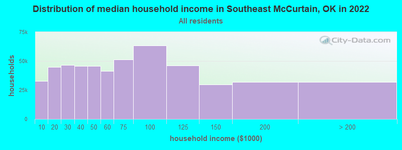
| Southeast McCurtain: | $41,112 |
| OK: | $59,673 |
Estimated per capita income in 2022: $26,555 (it was $15,074 in 2000)
Southeast McCurtain CCD income, earnings, and wages data
Estimated median house or condo value in 2022: $99,926 (it was $36,300 in 2000)
| Southeast McCurtain: | $99,926 |
| OK: | $191,700 |
Mean prices in 2022: all housing units: $164,293; detached houses: $180,472; townhouses or other attached units: $117,597; mobile homes: $56,718; occupied boats, rvs, vans, etc.: $8,076
Southeast McCurtain, OK residents, houses, and apartments details
Detailed information about poverty and poor residents in Southeast McCurtain, OK
Compare current foreclosures near Southeast McCurtain, OK:
| Photo | Address | Area | Beds / Baths | Price | Details |
|---|---|---|---|---|---|

|
#1
E 3rd Ave
Foreman, AR 71836
|
2,508 sq. feet
|
3 baths - beds |
$17,900
|
show details |

|
#2
Garfield St
Idabel, OK 74745
|
1,819 sq. feet
|
1 baths 4 beds |
show details | |

|
#3
NW 11th St
Idabel, OK 74745
|
1,128 sq. feet
|
1 baths 2 beds |
show details | |

|
#4
Stephens St
Foreman, AR 71836
|
1,944 sq. feet
|
2 baths - beds |
show details | |

|
#5
Cassie St
Haworth, OK 74740
|
- sq. feet
|
- baths - beds |
show details | |

|
#6
Peridot Rd
Haworth, OK 74740
|
- sq. feet
|
- baths - beds |
show details | |

|
#7
Little River 65
Foreman, AR 71836
|
- sq. feet
|
- baths - beds |
show details | |

|
#8
County Road 3301
De Kalb, TX 75559
|
1,560 sq. feet
|
- baths - beds |
show details | |

|
#9
NE Ave C
Idabel, OK 74745
|
- sq. feet
|
- baths - beds |
show details | |

|
#10
S 4th St
Foreman, AR 71836
|
- sq. feet
|
- baths - beds |
show details |
| Photo | Address | Area | Beds / Baths | Price | Details |
|---|---|---|---|---|---|

|
#11
Spring St
Foreman, AR 71836
|
- sq. feet
|
- baths - beds |
show details | |

|
#12
County Road 3209
De Kalb, TX 75559
|
- sq. feet
|
- baths - beds |
show details | |

|
Check over 1 million property listings on Foreclosure.com!
|
browse all offers | |||

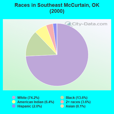
- 2,21374.2%White alone
- 40513.6%Black alone
- 1926.4%American Indian alone
- 1083.6%Two or more races
- 602.0%Hispanic
- 40.1%Asian alone
Races in Southeast McCurtain detailed stats: ancestries, foreign born residents, place of birth
 Recent articles from our blog. Our writers, many of them Ph.D. graduates or candidates, create easy-to-read articles on a wide variety of topics.
Current Local Time: CST time zone
Land area: 282.0 square miles.
Population density: 10 people per square mile (very low).

| Southeast McCurtain CCD: | 0.5% ($199) |
| Oklahoma: | 0.8% ($523) |
Nearest city with pop. 50,000+: Longview, TX  (89.0 miles , pop. 73,344).
Nearest city with pop. 200,000+: Shreveport, LA (104.0 miles , pop. 200,145).
Nearest city with pop. 1,000,000+: Dallas, TX (142.7 miles , pop. 1,188,580).
Nearest cities:
), ), ), ), Latitude: 33.79 N, Longitude: 94.62 W

| Here: | 4.5% |
| Oklahoma: | 3.2% |
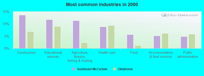
- Construction (13.7%)
- Educational services (11.8%)
- Agriculture, forestry, fishing & hunting (11.3%)
- Health care (8.9%)
- Food (5.7%)
- Accommodation & food services (5.2%)
- Public administration (4.8%)
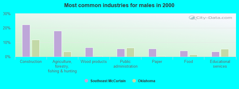
- Construction (22.4%)
- Agriculture, forestry, fishing & hunting (17.9%)
- Wood products (6.4%)
- Public administration (5.6%)
- Paper (5.6%)
- Food (4.1%)
- Educational services (3.6%)
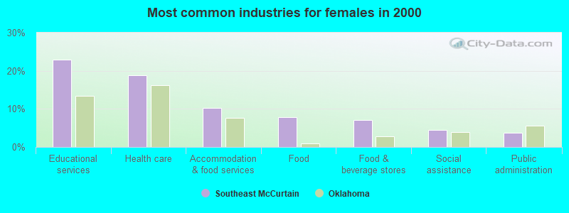
- Educational services (22.8%)
- Health care (18.8%)
- Accommodation & food services (10.2%)
- Food (7.8%)
- Food & beverage stores (7.1%)
- Social assistance (4.4%)
- Public administration (3.8%)
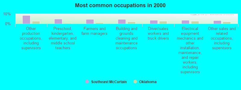
- Other production occupations, including supervisors (8.4%)
- Preschool, kindergarten, elementary, and middle school teachers (4.8%)
- Farmers and farm managers (4.5%)
- Building and grounds cleaning and maintenance occupations (4.5%)
- Driver/sales workers and truck drivers (3.8%)
- Electrical equipment mechanics and other installation, maintenance, and repair workers, including supervisors (3.7%)
- Other sales and related occupations, including supervisors (3.4%)
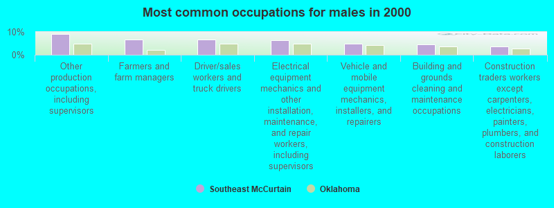
- Other production occupations, including supervisors (9.2%)
- Farmers and farm managers (6.7%)
- Driver/sales workers and truck drivers (6.6%)
- Electrical equipment mechanics and other installation, maintenance, and repair workers, including supervisors (6.4%)
- Vehicle and mobile equipment mechanics, installers, and repairers (4.8%)
- Building and grounds cleaning and maintenance occupations (4.6%)
- Construction traders workers except carpenters, electricians, painters, plumbers, and construction laborers (3.8%)
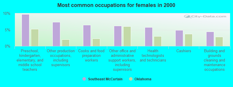
- Preschool, kindergarten, elementary, and middle school teachers (9.8%)
- Other production occupations, including supervisors (7.3%)
- Cooks and food preparation workers (6.4%)
- Other office and administrative support workers, including supervisors (6.2%)
- Health technologists and technicians (5.8%)
- Cashiers (4.9%)
- Building and grounds cleaning and maintenance occupations (4.4%)
Average climate in Southeast McCurtain, Oklahoma
Based on data reported by over 4,000 weather stations


Tornado activity:
Southeast McCurtain-area historical tornado activity is below Oklahoma state average. It is 74% greater than the overall U.S. average.
On 4/2/1982, a category F5 (max. wind speeds 261-318 mph) tornado 14.8 miles away from the Southeast McCurtain place center injured 29 people and caused between $500,000 and $5,000,000 in damages.
On 4/2/1982, a category F4 (max. wind speeds 207-260 mph) tornado 21.9 miles away from the place center killed 3 people and injured 23 people and caused between $500,000 and $5,000,000 in damages.
Earthquake activity:
Southeast McCurtain-area historical earthquake activity is significantly above Oklahoma state average. It is 512% greater than the overall U.S. average.On 11/6/2011 at 03:53:10, a magnitude 5.7 (5.7 MW, Depth: 3.2 mi, Class: Moderate, Intensity: VI - VII) earthquake occurred 171.3 miles away from the city center
On 9/3/2016 at 12:02:44, a magnitude 5.8 (5.8 MW, Depth: 3.5 mi) earthquake occurred 224.1 miles away from Southeast McCurtain center
On 5/17/2012 at 08:12:00, a magnitude 4.8 (4.8 MW, Depth: 3.1 mi, Class: Light, Intensity: IV - V) earthquake occurred 129.8 miles away from the city center
On 11/7/2016 at 01:44:24, a magnitude 5.0 (5.0 MW, Depth: 2.8 mi) earthquake occurred 196.1 miles away from the city center
On 11/5/2011 at 07:12:45, a magnitude 4.8 (4.8 MW, Depth: 1.9 mi) earthquake occurred 172.1 miles away from Southeast McCurtain center
On 11/8/2011 at 02:46:57, a magnitude 4.8 (4.8 MW, Depth: 3.1 mi) earthquake occurred 172.2 miles away from Southeast McCurtain center
Magnitude types: moment magnitude (MW)
Natural disasters:
The number of natural disasters in McCurtain County (16) is near the US average (15).Major Disasters (Presidential) Declared: 10
Emergencies Declared: 5
Causes of natural disasters: Floods: 7, Storms: 7, Winter Storms: 7, Tornadoes: 4, Hurricane: 1, Snow: 1, Wind: 1, Other: 1 (Note: some incidents may be assigned to more than one category).
Hospitals and medical centers near Southeast McCurtain:
- MCCURTAIN MEMORIAL HOSPITAL Acute Care Hospitals (about 12 miles away; IDABEL, OK)
- HOSPICE CENTER OF SOUTHEASTERN OKLAHOMA, INC (Hospital, about 12 miles away; IDABEL, OK)
- MCCURTAIN MEMORIAL HOME HEALTH (Home Health Center, about 13 miles away; IDABEL, OK)
- MEMORIAL HEIGHTS NURSING CENTER (Nursing Home, about 14 miles away; IDABEL, OK)
- HEALTHBACK OF IDABEL (Home Health Center, about 14 miles away; IDABEL, OK)
- TRI-COUNTY HOSPICE, INC (Hospital, about 14 miles away; IDABEL, OK)
- NURSES TO GO, INC (Home Health Center, about 15 miles away; IDABEL, OK)
Colleges/universities with over 2000 students nearest to Southeast McCurtain:
- Texarkana College (about 40 miles; Texarkana, TX; Full-time enrollment: 2,629)
- Northeast Texas Community College (about 50 miles; Mount Pleasant, TX; FT enrollment: 2,320)
- Paris Junior College (about 54 miles; Paris, TX; FT enrollment: 3,875)
- Texas A & M University-Commerce (about 84 miles; Commerce, TX; FT enrollment: 8,890)
- Carl Albert State College (about 87 miles; Poteau, OK; FT enrollment: 2,041)
- Southern Arkansas University Main Campus (about 88 miles; Magnolia, AR; FT enrollment: 3,005)
- LeTourneau University (about 92 miles; Longview, TX; FT enrollment: 2,357)
Points of interest:
Notable locations in Southeast McCurtain: Jadie Lookout (A), Bakhoma Recreation Area (B), Welch Store (C), Tiak Work Center (D), Tom Lookout (E), Haworth Volunteer Fire Department Station 1 (F), Tom Volunteer Fire Department (G), Haworth Volunteer Fire Department Station 2 (H), Haworth Volunteer Fire Department Station 3 (I), Shinewell Fire Department Goodwater Substation (J), Shinewell Volunteer Fire Department (K). Display/hide their locations on the map
Churches in Southeast McCurtain include: Antioch Church (A), Bethel Church (B), Bright Star Church (C), Choctaw Church (D), Galilee Church (E), Thomas Chapel (F). Display/hide their locations on the map
Cemeteries: Bokhoma Cemetery (1), Byrms Cemetery (2), Eastport Cemetery (3), Harris Cemetery (4), Haworth Cemetery (5), Manning Cemetery (6), Pine Ridge Cemetery (7). Display/hide their locations on the map
Lakes, reservoirs, and swamps: Grassy Lake (A), Churchhouse Lake (B), Nineteen hundred and Eight Cut-off Lake (C), New Lake (D), Breedlove Lake (E), Long Log Lake (F), Snag Lake (G), Clear Lake (H). Display/hide their locations on the map
Streams, rivers, and creeks: Holly Branch (A), Goodwater Creek (B), Dry Branch (C), Middle Caney Creek (D), Black Creek (E), Mud Creek (F), Norwood Creek (G), Parker Creek (H), Pine Creek (I). Display/hide their locations on the map
| This place: | 2.5 people |
| Oklahoma: | 2.5 people |
| This place: | 70.5% |
| Whole state: | 66.8% |
| This place: | 5.1% |
| Whole state: | 5.9% |
Likely homosexual households (counted as self-reported same-sex unmarried-partner households)
- Lesbian couples: 0.5% of all households
- Gay men: 0.1% of all households
| This place: | 24.5% |
| Whole state: | 14.7% |
| This place: | 9.5% |
| Whole state: | 6.1% |
For population 15 years and over in Southeast McCurtain:
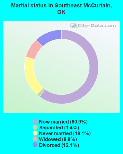
- Never married: 18.1%
- Now married: 60.9%
- Separated: 1.4%
- Widowed: 8.8%
- Divorced: 12.1%
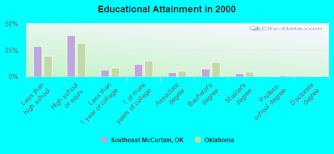
For population 25 years and over in Southeast McCurtain:
- High school or higher: 71.1%
- Bachelor's degree or higher: 10.5%
- Graduate or professional degree: 3.2%
- Unemployed: 9.5%
- Mean travel time to work (commute): 27.2 minutes
| Here: | 13.3 |
| Oklahoma average: | 11.7 |
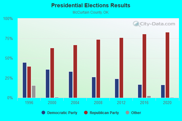
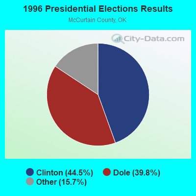
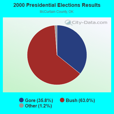
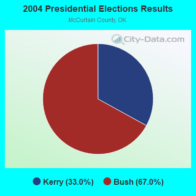

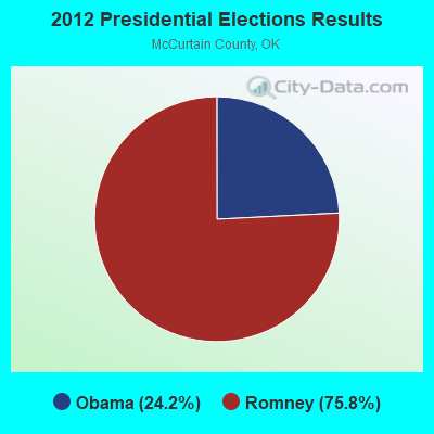
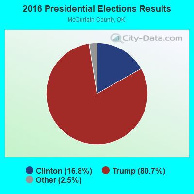
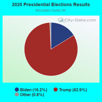
Graphs represent county-level data. Detailed 2008 Election Results
Religion statistics for Southeast McCurtain, OK (based on McCurtain County data)
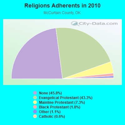
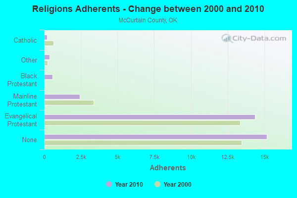
| Religion | Adherents | Congregations |
|---|---|---|
| Evangelical Protestant | 14,352 | 94 |
| Mainline Protestant | 2,422 | 31 |
| Black Protestant | 589 | 4 |
| Other | 381 | 5 |
| Catholic | 215 | 1 |
| None | 15,192 | - |
Food Environment Statistics:
| Here: | 3.29 / 10,000 pop. |
| Oklahoma: | 1.97 / 10,000 pop. |
| This county: | 0.30 / 10,000 pop. |
| State: | 0.76 / 10,000 pop. |
| This county: | 7.78 / 10,000 pop. |
| Oklahoma: | 4.35 / 10,000 pop. |
| McCurtain County: | 3.59 / 10,000 pop. |
| Oklahoma: | 6.89 / 10,000 pop. |
| McCurtain County: | 10.5% |
| Oklahoma: | 10.3% |
| McCurtain County: | 31.0% |
| Oklahoma: | 29.2% |
Strongest AM radio stations in Southeast McCurtain:
- KEEL (710 AM; 50 kW; SHREVEPORT, LA; Owner: CITICASTERS LICENSES, L.P.)
- KWKH (1130 AM; 50 kW; SHREVEPORT, LA; Owner: CITICASTERS LICENSES, L.P.)
- KBEL (1240 AM; 1 kW; IDABEL, OK; Owner: HAROLD E. COCHRAN)
- KPYN (900 AM; 10 kW; ATLANTA, TX; Owner: FAMILY WORSHIP CENTER CHURCH, INC.)
- KFXR (1190 AM; 50 kW; DALLAS, TX; Owner: CLEAR CHANNEL BROADCASTING LICENSES, INC.)
- KNBO (1530 AM; daytime; 2 kW; NEW BOSTON, TX; Owner: BOWIE COUNTY BROADCASTING CO., INC.)
- KRLD (1080 AM; 50 kW; DALLAS, TX; Owner: TEXAS INFINITY BROADCASTING L.P.)
- KGHT (880 AM; 50 kW; SHERIDAN, AR; Owner: METROPOLITAN RADIO GROUP, INC.)
- WBAP (820 AM; 50 kW; FORT WORTH, TX; Owner: WBAP-KSCS OPERATING, LTD.)
- KAAY (1090 AM; 50 kW; LITTLE ROCK, AR; Owner: CITADEL BROADCASTING COMPANY)
- KRMG (740 AM; 50 kW; TULSA, OK; Owner: CXR HOLDINGS, INC.)
- KSKY (660 AM; 20 kW; BALCH SPRINGS, TX; Owner: BISON MEDIA, INC.)
- KTFS (940 AM; 2 kW; TEXARKANA, TX; Owner: ARKLATEX, LLC)
Strongest FM radio stations in Southeast McCurtain:
- KBEL-FM (96.7 FM; IDABEL, OK; Owner: HAROLD E. COCHRAN)
- KQIB (102.9 FM; IDABEL, OK; Owner: JDC RADIO, INC.)
- KPLT-FM (107.7 FM; PARIS, TX; Owner: EAST TEXAS BROADCASTING, INC.)
- KKBI (106.1 FM; BROKEN BOW, OK; Owner: J.D.C. RADIO, INC.)
- KEWL-FM (95.1 FM; NEW BOSTON, TX; Owner: PETRACOM OF TEXARKANA, L.L.C.)
- KZRB (103.5 FM; NEW BOSTON, TX; Owner: B & H BROADCASTING SYSTEMS, INC.)
- KXRT (90.9 FM; IDABEL, OK; Owner: AMERICAN FAMILY ASSOCIATION)
- KMJI (93.3 FM; ASHDOWN, AR; Owner: CLEAR CHANNEL BROADCASTING LICENSES, INC.)
TV broadcast stations around Southeast McCurtain:
- K28DJ (Channel 28; BROKEN BOW, OK; Owner: TRUSTEES OF J.B.CALLAHAM R.T.)
- K63BA (Channel 63; IDABEL, OK; Owner: OKLAHOMA EDUCATIONAL TELEVISION AUTHORITY)
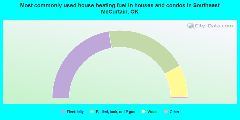
- 44.7%Electricity
- 39.5%Bottled, tank, or LP gas
- 15.0%Wood
- 0.4%Utility gas
- 0.2%Fuel oil, kerosene, etc.
- 0.2%Other fuel
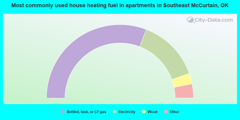
- 61.7%Bottled, tank, or LP gas
- 27.5%Electricity
- 4.7%Wood
- 3.6%Utility gas
- 1.6%Other fuel
- 1.0%No fuel used
Southeast McCurtain compared to Oklahoma state average:
- Median house value below state average.
- Black race population percentage above state average.
- Hispanic race population percentage significantly below state average.
- Foreign-born population percentage significantly below state average.
- Renting percentage below state average.
- Length of stay since moving in significantly above state average.
- Number of rooms per house significantly below state average.
- House age significantly below state average.
- Number of college students below state average.
- Percentage of population with a bachelor's degree or higher below state average.