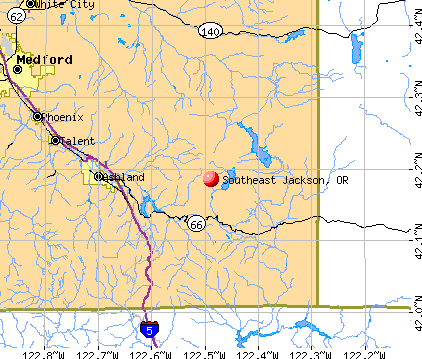
Southeast Jackson, Oregon
Submit your own pictures of this place and show them to the world
- OSM Map
- General Map
- Google Map
- MSN Map
| Males: 1,033 | |
| Females: 991 |
| Median resident age: | 45.6 years |
| Oregon median age: | 36.3 years |
Zip code: 97520
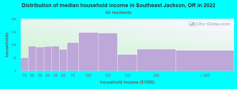
| Southeast Jackson: | $85,165 |
| OR: | $75,657 |
Estimated per capita income in 2022: $47,436 (it was $24,495 in 2000)
Southeast Jackson CCD income, earnings, and wages data
Estimated median house or condo value in 2022: $856,234 (it was $265,700 in 2000)
| Southeast Jackson: | $856,234 |
| OR: | $475,600 |
Mean prices in 2022: all housing units: $446,489; detached houses: $485,243; townhouses or other attached units: $329,387; in 2-unit structures: $488,232; in 3-to-4-unit structures: $564,510; in 5-or-more-unit structures: $375,230; mobile homes: $198,710; occupied boats, rvs, vans, etc.: $46,373
Southeast Jackson, OR residents, houses, and apartments details
Detailed information about poverty and poor residents in Southeast Jackson, OR


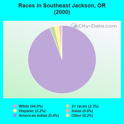
- 1,74494.0%White alone
- 432.3%Two or more races
- 412.2%Hispanic
- 150.8%Asian alone
- 80.4%American Indian alone
- 30.2%Other race alone
- 10.05%Black alone
- 10.05%Native Hawaiian and Other
Pacific Islander alone
Races in Southeast Jackson detailed stats: ancestries, foreign born residents, place of birth
 Recent articles from our blog. Our writers, many of them Ph.D. graduates or candidates, create easy-to-read articles on a wide variety of topics.

Current Local Time: PST time zone
Land area: 545.5 square miles.
Population density: 3.7 people per square mile (very low).

| Southeast Jackson CCD: | 0.9% ($2,385) |
| Oregon: | 1.2% ($1,687) |
Nearest city with pop. 50,000+: Medford, OR  (21.6 miles , pop. 63,154).
Nearest city with pop. 200,000+: Northwest Clackamas, OR (222.2 miles , pop. 224,220).
Nearest city with pop. 1,000,000+: Los Angeles, CA (603.0 miles , pop. 3,694,820).
Nearest cities:
), ), )Latitude: 42.19 N, Longitude: 122.49 W
Area code commonly used in this area: 541

| Here: | 4.3% |
| Oregon: | 3.9% |
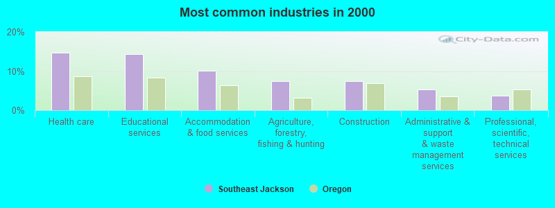
- Health care (14.7%)
- Educational services (14.3%)
- Accommodation & food services (10.1%)
- Agriculture, forestry, fishing & hunting (7.5%)
- Construction (7.4%)
- Administrative & support & waste management services (5.3%)
- Professional, scientific, technical services (3.8%)
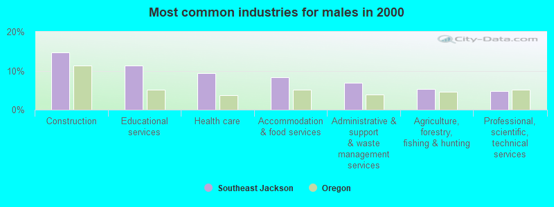
- Construction (14.6%)
- Educational services (11.3%)
- Health care (9.4%)
- Accommodation & food services (8.4%)
- Administrative & support & waste management services (7.0%)
- Agriculture, forestry, fishing & hunting (5.3%)
- Professional, scientific, technical services (4.8%)
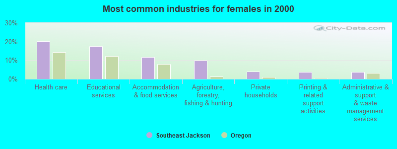
- Health care (20.1%)
- Educational services (17.4%)
- Accommodation & food services (11.8%)
- Agriculture, forestry, fishing & hunting (9.8%)
- Private households (3.9%)
- Printing & related support activities (3.7%)
- Administrative & support & waste management services (3.7%)
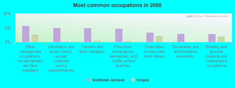
- Other management occupations, except farmers and farm managers (5.8%)
- Information and record clerks, except customer service representatives (5.1%)
- Farmers and farm managers (5.0%)
- Preschool, kindergarten, elementary, and middle school teachers (4.7%)
- Driver/sales workers and truck drivers (3.4%)
- Secretaries and administrative assistants (3.0%)
- Building and grounds cleaning and maintenance occupations (2.9%)
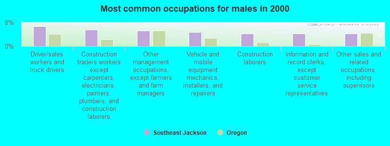
- Driver/sales workers and truck drivers (6.7%)
- Construction traders workers except carpenters, electricians, painters, plumbers, and construction laborers (5.5%)
- Other management occupations, except farmers and farm managers (5.3%)
- Vehicle and mobile equipment mechanics, installers, and repairers (4.8%)
- Construction laborers (4.3%)
- Information and record clerks, except customer service representatives (4.3%)
- Other sales and related occupations, including supervisors (4.3%)
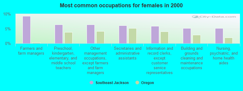
- Farmers and farm managers (9.3%)
- Preschool, kindergarten, elementary, and middle school teachers (6.4%)
- Other management occupations, except farmers and farm managers (6.4%)
- Secretaries and administrative assistants (6.1%)
- Information and record clerks, except customer service representatives (5.9%)
- Building and grounds cleaning and maintenance occupations (5.1%)
- Nursing, psychiatric, and home health aides (5.1%)
Average climate in Southeast Jackson, Oregon
Based on data reported by over 4,000 weather stations


(lower is better)
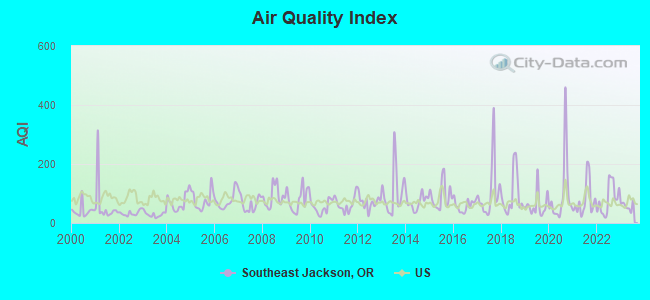
Air Quality Index (AQI) level in 2023 was 57.7. This is better than average.
| City: | 57.7 |
| U.S.: | 72.6 |
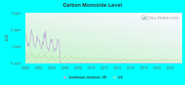
Carbon Monoxide (CO) [ppm] level in 2004 was 1.04. This is significantly worse than average. Closest monitor was 21.9 miles away from the city center.
| City: | 1.04 |
| U.S.: | 0.25 |
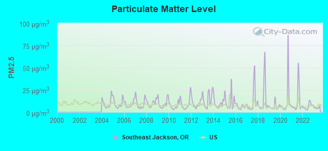
Particulate Matter (PM2.5) [µg/m3] level in 2023 was 5.00. This is significantly better than average. Closest monitor was 21.9 miles away from the city center.
| City: | 5.00 |
| U.S.: | 8.11 |
Earthquake activity:
Southeast Jackson-area historical earthquake activity is significantly above Oregon state average. It is 3551% greater than the overall U.S. average.On 1/31/1922 at 13:17:28, a magnitude 7.6 (7.6 UK, Class: Major, Intensity: VIII - XII) earthquake occurred 189.2 miles away from Southeast Jackson center
On 11/8/1980 at 10:27:34, a magnitude 7.2 (6.2 MB, 7.2 MS, 7.2 MW, 7.0 ML) earthquake occurred 119.6 miles away from the city center
On 4/18/1906 at 13:12:21, a magnitude 7.9 (7.9 UK) earthquake occurred 290.8 miles away from the city center, causing $524,000,000 total damage
On 4/25/1992 at 18:06:04, a magnitude 7.2 (6.3 MB, 7.1 MS, 7.2 MW, 7.1 MW, Depth: 9.4 mi) earthquake occurred 151.2 miles away from the city center, causing $75,000,000 total damage
On 8/17/1991 at 22:17:14, a magnitude 7.1 (6.2 MB, 7.1 MS, 7.1 MW, 6.8 ML, Depth: 8.4 mi) earthquake occurred 162.1 miles away from Southeast Jackson center
On 1/22/1923 at 09:04:18, a magnitude 7.2 (7.2 UK) earthquake occurred 188.4 miles away from Southeast Jackson center
Magnitude types: body-wave magnitude (MB), local magnitude (ML), surface-wave magnitude (MS), moment magnitude (MW)
Natural disasters:
The number of natural disasters in Jackson County (12) is smaller than the US average (15).Major Disasters (Presidential) Declared: 5
Emergencies Declared: 2
Causes of natural disasters: Fires: 5, Floods: 4, Storms: 2, Drought: 1, Heavy Rain: 1, Hurricane: 1, Landslide: 1, Mudslide: 1, Snow: 1, Wind: 1, Winter Storm: 1, Other: 1 (Note: some incidents may be assigned to more than one category).
Hospitals and medical centers near Southeast Jackson:
- ASHLAND HOME HEALTH AGENCY (Home Health Center, about 10 miles away; ASHLAND, OR)
- LINDA VISTA CARE CENTER (Nursing Home, about 13 miles away; ASHLAND, OR)
- LINDA VISTA NURSING AND REHAB CENTER (Nursing Home, about 13 miles away; ASHLAND, OR)
- ASHLAND COMMUNITY HOSPITAL Acute Care Hospitals (about 13 miles away; ASHLAND, OR)
Colleges/universities with over 2000 students nearest to Southeast Jackson:
- Southern Oregon University (about 11 miles; Ashland, OR; Full-time enrollment: 4,650)
- Oregon Institute of Technology (about 37 miles; Klamath Falls, OR; FT enrollment: 2,900)
- Rogue Community College (about 49 miles; Grants Pass, OR; FT enrollment: 3,600)
- Shasta College (about 109 miles; Redding, CA; FT enrollment: 5,645)
- Humboldt State University (about 123 miles; Arcata, CA; FT enrollment: 7,353)
- Lane Community College (about 130 miles; Eugene, OR; FT enrollment: 6,373)
- University of Oregon (about 132 miles; Eugene, OR; FT enrollment: 23,329)
Points of interest:
Notable locations in Southeast Jackson: Gawa Church Camp (A), Owens Ranch (B), Elder Ranch (C), Hyatt Lake Campground (D), Fish Lake Resort (E), Fish Lake Recreation Site (F), North Fork Recreation Site (G), Deadwood Junction (H), Box O Ranch (I), Taylor Ranch (J), Leonard Ranch (K), Fall Creek Ranch (L), Deadwood (M), Beaver Dam Recreation Site (N), Daley Creek Recreation Site (O), Cabin Sixty-nine (P), Burnt Creek Ranch (Q), Box D Ranch (R), Summit Ranch (S), Klum Landing Jackson County Boat Ramp (T). Display/hide their locations on the map
Cemeteries: Pinehurst Cemetery (1), Lake Creek Cemetery (2). Display/hide their locations on the map
Lakes and reservoirs: Hobart Lake (A), Lost Lake (B), Chapman Lake (C), Parsnip Lakes (D), Big Lake (E), Ice House Lake (F), Rosebud Helipond (G), Hyatt Reservoir (H). Display/hide their locations on the map
Creeks: Johnson Creek (A), Hoxie Creek (B), Randle Creek (C), Mud Creek (D), Bluejay Creek (E), Swamp Creek (F), Barron Creek (G), Green Creek (H), Ellick Creek (I). Display/hide their locations on the map
Parks in Southeast Jackson include: Tub Springs State Park (1), Willow Point County Campground (2), Sugar Pine County Group Campground (3), Howard Prairie County Recreation Area (4), Asperkaha County Campground (5), Hooper Springs County Wayside (6), Howard Prairie County Resort (7), Lilly Glen County Campground (8), Grizzly County Campground (9). Display/hide their locations on the map
| This place: | 2.3 people |
| Oregon: | 2.5 people |
| This place: | 69.2% |
| Whole state: | 63.4% |
| This place: | 8.1% |
| Whole state: | 8.0% |
Likely homosexual households (counted as self-reported same-sex unmarried-partner households)
- Lesbian couples: 1.1% of all households
- Gay men: 0.6% of all households
| This place: | 9.0% |
| Whole state: | 11.6% |
| This place: | 4.1% |
| Whole state: | 5.0% |
For population 15 years and over in Southeast Jackson:
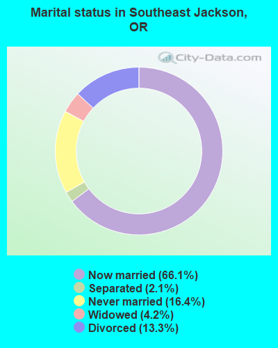
- Never married: 16.4%
- Now married: 66.1%
- Separated: 2.1%
- Widowed: 4.2%
- Divorced: 13.3%
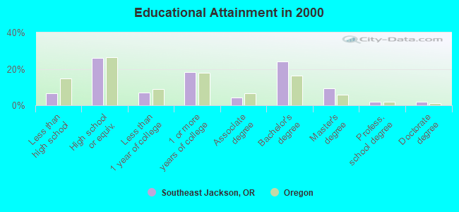
For population 25 years and over in Southeast Jackson:
- High school or higher: 93.4%
- Bachelor's degree or higher: 37.5%
- Graduate or professional degree: 13.3%
- Unemployed: 6.0%
- Mean travel time to work (commute): 22.6 minutes
| Here: | 10.0 |
| Oregon average: | 11.5 |
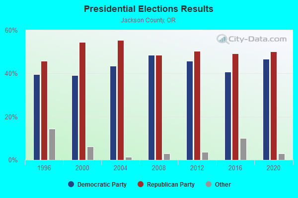
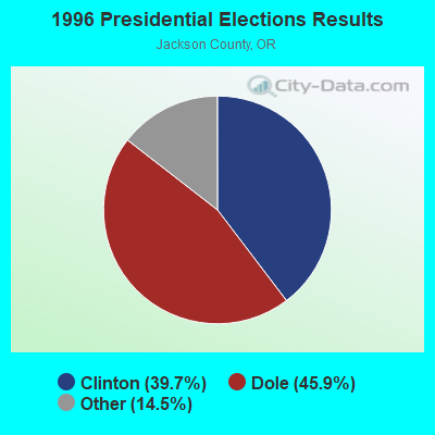
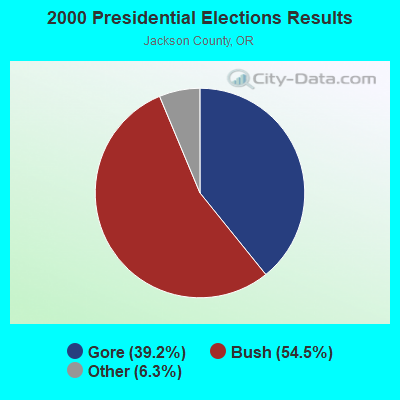
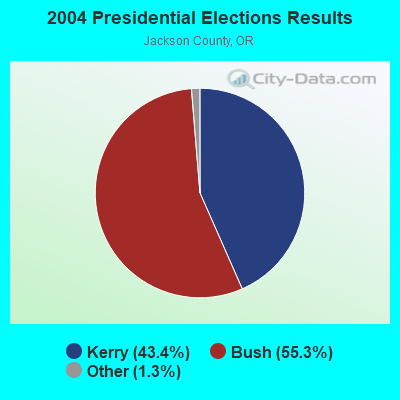
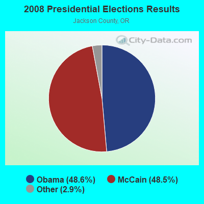
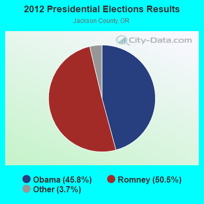
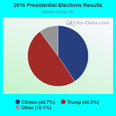
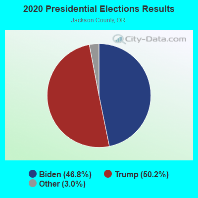
Graphs represent county-level data. Detailed 2008 Election Results
Religion statistics for Southeast Jackson, OR (based on Jackson County data)
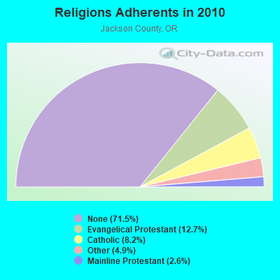
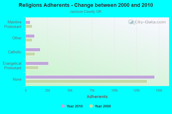
| Religion | Adherents | Congregations |
|---|---|---|
| Evangelical Protestant | 25,890 | 122 |
| Catholic | 16,565 | 6 |
| Other | 10,057 | 44 |
| Mainline Protestant | 5,252 | 23 |
| Orthodox | 100 | 2 |
| None | 145,342 | - |
Food Environment Statistics:
| Here: | 1.66 / 10,000 pop. |
| State: | 2.03 / 10,000 pop. |
| Jackson County: | 0.30 / 10,000 pop. |
| Oregon: | 0.33 / 10,000 pop. |
| Jackson County: | 2.26 / 10,000 pop. |
| Oregon: | 2.01 / 10,000 pop. |
| This county: | 1.66 / 10,000 pop. |
| State: | 1.69 / 10,000 pop. |
| This county: | 10.00 / 10,000 pop. |
| State: | 9.93 / 10,000 pop. |
| This county: | 7.9% |
| Oregon: | 7.4% |
| This county: | 23.2% |
| Oregon: | 25.6% |
| Jackson County: | 11.1% |
| Oregon: | 14.2% |
Strongest AM radio stations in Southeast Jackson:
- KTMT (580 AM; 10 kW; ASHLAND, OR; Owner: MAPLETON COMMUNICATIONS, LLC)
- KAPL (1300 AM; 20 kW; PHOENIX, OR; Owner: APPLEGATE MEDIA, INC.)
- KRTA (610 AM; 5 kW; MEDFORD, OR; Owner: OPUS BROADCASTING SYSTEMS, INC.)
- KMED (1440 AM; 5 kW; MEDFORD, OR; Owner: CITICASTERS LICENSES, L.P.)
- KGRV (700 AM; 25 kW; WINSTON, OR; Owner: PACIFIC CASCADE COMMUNICATIONS CORP.)
- KSJK (1230 AM; 1 kW; TALENT, OR; Owner: ST. OF OR. ACT & ST. BD. OF HGR ED.)
- KLVB (730 AM; 1 kW; MEDFORD, OR)
- KAJO (1270 AM; 10 kW; GRANTS PASS, OR; Owner: GRANTS PASS BROADCASTING CORPORATION)
- KAGO (1150 AM; 5 kW; KLAMATH FALLS, OR; Owner: NEW NORTHWEST BROADCASTERS, LLC)
- KCMX (880 AM; 1 kW; PHOENIX, OR; Owner: MAPLETON COMMUNICATIONS, LLC)
- KPNW (1120 AM; 50 kW; EUGENE, OR; Owner: CAPSTAR TX LIMITED PARTNERSHIP)
- KKJX (960 AM; 5 kW; KLAMATH FALLS, OR; Owner: NEW NORTHWEST BROADCASTERS, LLC)
- KDUN (1030 AM; 50 kW; REEDSPORT, OR; Owner: PAMPLIN BROADCASTING-OREGON, INC.)
Strongest FM radio stations in Southeast Jackson:
- KAKT (105.1 FM; PHOENIX, OR; Owner: MAPLETON COMMUNICATIONS, LLC)
- KTMT-FM (93.7 FM; MEDFORD, OR; Owner: MAPLETON COMMUNICATIONS, LLC)
- KKRB (106.9 FM; KLAMATH FALLS, OR; Owner: WYNNE BROADCASTING COMPANY, INC.)
- KLDZ (103.5 FM; MEDFORD, OR; Owner: CITICASTERS LICENSES, L.P.)
- KIFS (107.5 FM; ASHLAND, OR; Owner: CITICASTERS LICENSES, L.P.)
- K216DR (91.1 FM; CENTRAL POINT, OR; Owner: EDUCATIONAL MEDIA FOUNDATION)
- K209CP (89.7 FM; TALENT, OR; Owner: EDUCATIONAL MEDIA FOUNDATION)
- K204CY (88.7 FM; MEDFORD, OR; Owner: EDUCATIONAL MEDIA FOUNDATION)
- KSMF (89.1 FM; ASHLAND, OR; Owner: STATE OF OREGON/STATE BD HIGHER EDUC)
- KSRG (88.3 FM; ASHLAND, OR; Owner: ST. BOARD OF HIGHER ED/SO. OR ST COL)
- K227AA (93.3 FM; ASHLAND, ETC., OR; Owner: MAPLETON COMMUNICATIONS, LLC)
- K254AD (98.7 FM; MEDFORD, OR; Owner: GRANTS PASS BROADCASTING CORPORATION)
- KZZE (106.3 FM; EAGLE POINT, OR; Owner: CITICASTERS LICENSES, L.P.)
- K284AE (104.7 FM; ASHLAND, OR; Owner: MAPLETON COMMUNICATIONS, LLC)
- K214BO (90.7 FM; ASHLAND, OR; Owner: FAMILY STATIONS, INC.)
- KKLJ (88.9 FM; KLAMATH FALLS, OR; Owner: EDUCATIONAL MEDIA FOUNDATION)
- KRAT (97.7 FM; ALTAMONT, OR; Owner: GEORGE J. WADE)
- K204DM (88.5 FM; YREKA, CA; Owner: CALVARY CHAPEL OF TWIN FALLS, INC.)
- KFEG (104.7 FM; KLAMATH FALLS, OR; Owner: COVE ROAD PUBLISHING LLC)
- KLAD-FM (92.5 FM; KLAMATH FALLS, OR; Owner: NEW NORTHWEST BROADCASTERS, LLC)
TV broadcast stations around Southeast Jackson:
- K13PF (Channel 13; PINEHURST, OR; Owner: SOUTHERN OREGON PUBLIC TELEVISION)
- KTVL (Channel 10; MEDFORD, OR; Owner: FREEDOM BROADCASTING OF OREGON, INC.)
- KMVU (Channel 26; MEDFORD, OR; Owner: BROADCASTING LICENSES, L.P.)
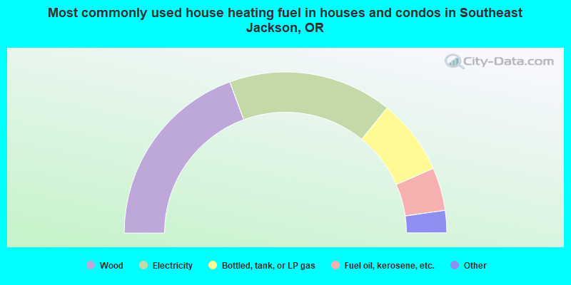
- 38.8%Wood
- 32.9%Electricity
- 15.2%Bottled, tank, or LP gas
- 8.6%Fuel oil, kerosene, etc.
- 3.3%Utility gas
- 1.2%Other fuel
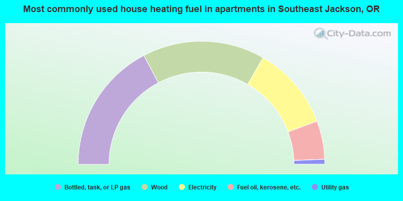
- 34.6%Bottled, tank, or LP gas
- 32.1%Wood
- 22.0%Electricity
- 10.1%Fuel oil, kerosene, etc.
- 1.3%Utility gas
Southeast Jackson compared to Oregon state average:
- Median house value above state average.
- Unemployed percentage below state average.
- Black race population percentage significantly below state average.
- Hispanic race population percentage significantly below state average.
- Median age significantly above state average.
- Foreign-born population percentage significantly below state average.
- Renting percentage below state average.
- Length of stay since moving in significantly above state average.
- Number of rooms per house significantly below state average.
- House age significantly below state average.
Southeast Jackson on our top lists:
- #7 on the list of "Top 101 cities with the most residents born in Born at sea (population 500+)"
- #26 on the list of "Top 101 counties with the largest increase in the number of births per 1000 residents 2000-2006 to 2007-2013 (pop 50,000+)"
- #34 on the list of "Top 101 counties with the highest percentage of residents that exercised in the past month"
- #46 on the list of "Top 101 counties with highest percentage of residents voting for 3rd party candidates in the 2012 Presidential Election (pop. 50,000+)"
- #68 on the list of "Top 101 counties with the highest percentage of residents that drank alcohol in the past 30 days"
- #71 on the list of "Top 101 counties with the highest percentage of residents that smoked 100+ cigarettes in their lives"