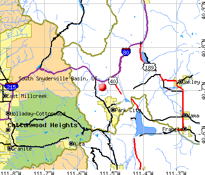
South Snyderville Basin, Utah
Submit your own pictures of this place and show them to the world
- OSM Map
- General Map
- Google Map
- MSN Map
| Males: 2,185 | |
| Females: 2,113 |
| Median resident age: | 36.8 years |
| Utah median age: | 27.1 years |
Zip codes: 84098.
| South Snyderville Basin: | $172,055 |
| UT: | $89,168 |
Estimated per capita income in 2022: $73,736 (it was $35,405 in 2000)
South Snyderville Basin CDP income, earnings, and wages data
Estimated median house or condo value in 2022: over $1,000,000 (it was $323,800 in 2000)
| South Snyderville Basin: | over $1,000,000 |
| UT: | $499,500 |
Mean prices in 2022: all housing units: over $1,000,000; detached houses: over $1,000,000; townhouses or other attached units: over $1,000,000; in 2-unit structures: over $1,000,000; in 3-to-4-unit structures: $527,565; in 5-or-more-unit structures: $863,653; mobile homes: $279,557
South Snyderville Basin, UT residents, houses, and apartments details
Detailed information about poverty and poor residents in South Snyderville Basin, UT
Compare current foreclosures near South Snyderville Basin, UT:


- 3,40493.6%White alone
- 1253.4%Hispanic
- 491.3%Two or more races
- 351.0%Asian alone
- 100.3%American Indian alone
- 50.1%Black alone
- 50.1%Other race alone
- 30.08%Native Hawaiian and Other
Pacific Islander alone
Races in South Snyderville Basin detailed stats: ancestries, foreign born residents, place of birth
 Recent articles from our blog. Our writers, many of them Ph.D. graduates or candidates, create easy-to-read articles on a wide variety of topics.

Ancestries: English (25.9%), German (15.5%), Irish (13.0%), Italian (7.0%), United States (5.8%), Norwegian (5.5%).
Current Local Time: MST time zone
Land area: 10.9 square miles.
Population density: 393 people per square mile (very low).
105 residents are foreign born (1.7% Europe, 0.6% Latin America, 0.6% Asia).
| This place: | 2.9% |
| Utah: | 7.1% |
| South Snyderville Basin CDP: | 0.6% ($1,836) |
| Utah: | 0.7% ($956) |
Nearest city with pop. 50,000+: Salt Lake City, UT  (19.6 miles , pop. 181,743).
Nearest city with pop. 200,000+: Northeast Jefferson, CO (345.2 miles , pop. 450,166).
Nearest city with pop. 1,000,000+: Phoenix, AZ (497.5 miles , pop. 1,321,045).
Nearest cities:
), ), ), ), ), ), )Latitude: 40.71 N, Longitude: 111.52 W
Area code commonly used in this area: 435

| Here: | 2.1% |
| Utah: | 2.5% |
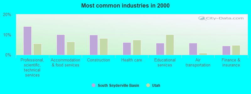
- Professional, scientific, technical services (14.1%)
- Accommodation & food services (10.1%)
- Construction (9.9%)
- Health care (6.2%)
- Educational services (5.9%)
- Air transportation (5.8%)
- Finance & insurance (4.5%)
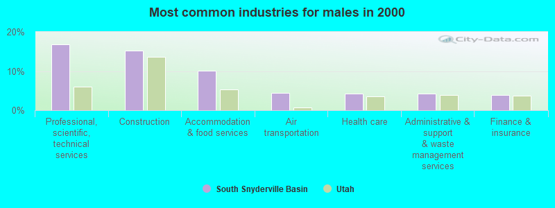
- Professional, scientific, technical services (16.7%)
- Construction (15.2%)
- Accommodation & food services (10.2%)
- Air transportation (4.4%)
- Health care (4.3%)
- Administrative & support & waste management services (4.3%)
- Finance & insurance (3.9%)
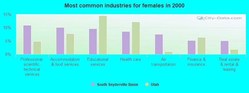
- Professional, scientific, technical services (11.0%)
- Accommodation & food services (10.1%)
- Educational services (9.7%)
- Health care (8.6%)
- Air transportation (7.6%)
- Finance & insurance (5.3%)
- Real estate & rental & leasing (5.2%)
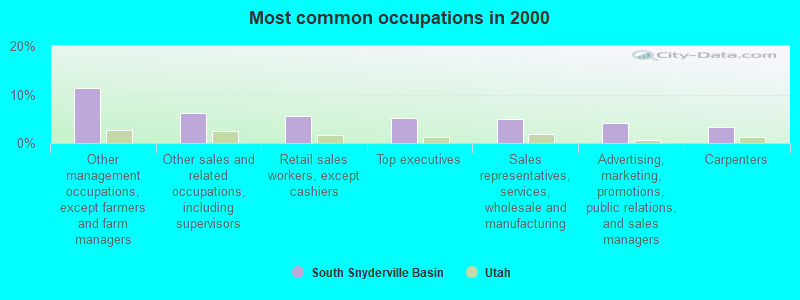
- Other management occupations, except farmers and farm managers (11.3%)
- Other sales and related occupations, including supervisors (6.1%)
- Retail sales workers, except cashiers (5.6%)
- Top executives (5.2%)
- Sales representatives, services, wholesale and manufacturing (5.0%)
- Advertising, marketing, promotions, public relations, and sales managers (4.1%)
- Carpenters (3.2%)
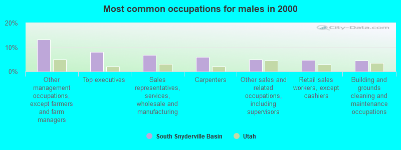
- Other management occupations, except farmers and farm managers (13.2%)
- Top executives (8.1%)
- Sales representatives, services, wholesale and manufacturing (6.9%)
- Carpenters (5.9%)
- Other sales and related occupations, including supervisors (5.0%)
- Retail sales workers, except cashiers (4.8%)
- Building and grounds cleaning and maintenance occupations (4.5%)
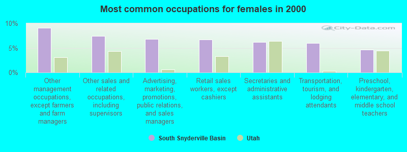
- Other management occupations, except farmers and farm managers (9.1%)
- Other sales and related occupations, including supervisors (7.5%)
- Advertising, marketing, promotions, public relations, and sales managers (6.8%)
- Retail sales workers, except cashiers (6.7%)
- Secretaries and administrative assistants (6.1%)
- Transportation, tourism, and lodging attendants (5.9%)
- Preschool, kindergarten, elementary, and middle school teachers (4.6%)
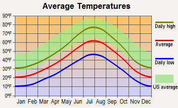
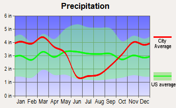
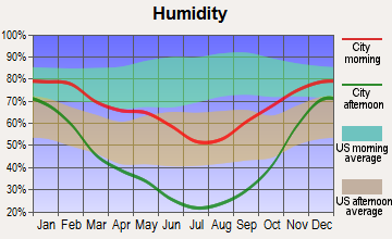
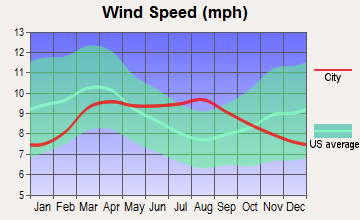
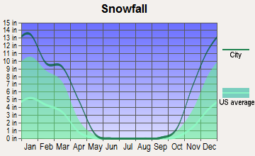
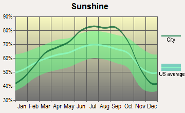
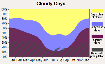
Average climate in South Snyderville Basin, Utah
Based on data reported by over 4,000 weather stations
(lower is better)
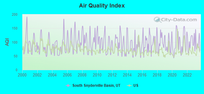
Air Quality Index (AQI) level in 2023 was 95.3. This is worse than average.
| City: | 95.3 |
| U.S.: | 72.6 |
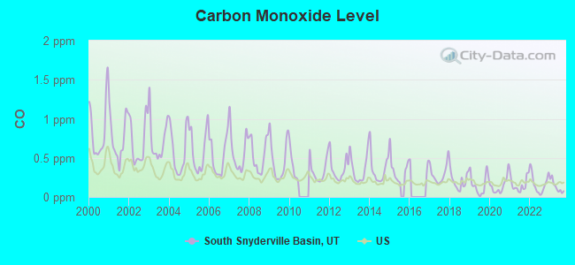
Carbon Monoxide (CO) [ppm] level in 2023 was 0.132. This is significantly better than average. Closest monitor was 17.6 miles away from the city center.
| City: | 0.132 |
| U.S.: | 0.251 |
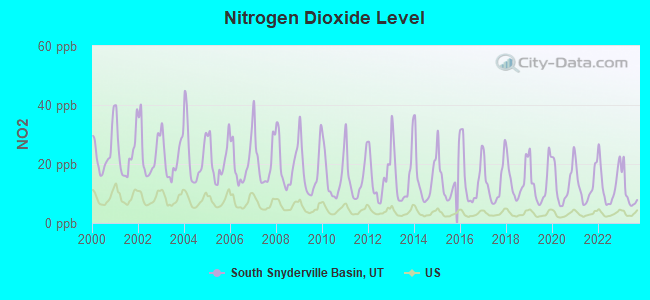
Nitrogen Dioxide (NO2) [ppb] level in 2023 was 10.1. This is significantly worse than average. Closest monitor was 17.6 miles away from the city center.
| City: | 10.1 |
| U.S.: | 5.1 |
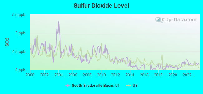
Sulfur Dioxide (SO2) [ppb] level in 2023 was 0.843. This is significantly better than average. Closest monitor was 18.4 miles away from the city center.
| City: | 0.843 |
| U.S.: | 1.515 |
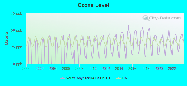
Ozone [ppb] level in 2023 was 36.0. This is about average. Closest monitor was 11.9 miles away from the city center.
| City: | 36.0 |
| U.S.: | 33.3 |
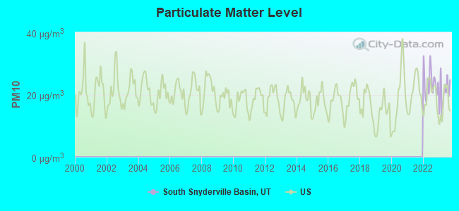
Particulate Matter (PM10) [µg/m3] level in 2023 was 20.8. This is about average. Closest monitor was 17.6 miles away from the city center.
| City: | 20.8 |
| U.S.: | 19.2 |
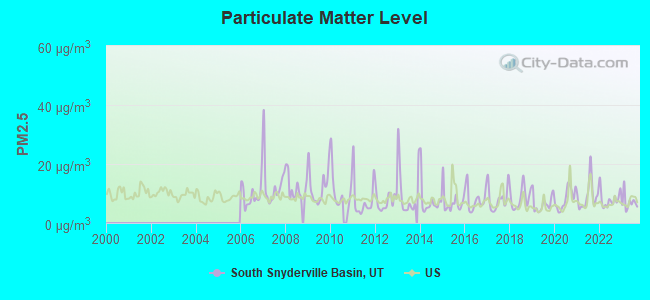
Particulate Matter (PM2.5) [µg/m3] level in 2023 was 7.03. This is about average. Closest monitor was 17.6 miles away from the city center.
| City: | 7.03 |
| U.S.: | 8.11 |
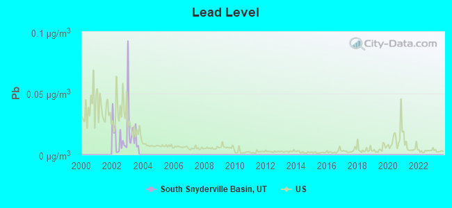
Lead (Pb) [µg/m3] level in 2003 was 0.0230. This is significantly worse than average. Closest monitor was 17.6 miles away from the city center.
| City: | 0.0230 |
| U.S.: | 0.0093 |
Earthquake activity:
South Snyderville Basin-area historical earthquake activity is significantly above Utah state average. It is 2087% greater than the overall U.S. average.On 8/18/1959 at 06:37:13, a magnitude 7.7 (7.7 UK, Class: Major, Intensity: VIII - XII) earthquake occurred 270.5 miles away from the city center, causing $26,000,000 total damage
On 10/3/1915 at 06:52:48, a magnitude 7.6 (7.6 UK) earthquake occurred 314.1 miles away from the city center
On 10/28/1983 at 14:06:06, a magnitude 7.3 (6.2 MB, 7.3 MS, 7.0 MW) earthquake occurred 260.5 miles away from the city center, causing 2 deaths (2 shaking deaths) and 3 injuries, causing $15,000,000 total damage
On 3/28/1975 at 02:31:05, a magnitude 6.2 (6.1 MB, 6.0 MS, 6.2 ML, Class: Strong, Intensity: VII - IX) earthquake occurred 102.8 miles away from South Snyderville Basin center
On 3/18/2020 at 13:09:31, a magnitude 5.7 (5.7 MW, Depth: 7.4 mi, Class: Moderate, Intensity: VI - VII) earthquake occurred 29.2 miles away from the city center
On 12/21/1932 at 06:10:09, a magnitude 7.2 (7.2 UK) earthquake occurred 381.1 miles away from South Snyderville Basin center
Magnitude types: body-wave magnitude (MB), local magnitude (ML), surface-wave magnitude (MS), moment magnitude (MW)
Natural disasters:
The number of natural disasters in Summit County (6) is a lot smaller than the US average (15).Major Disasters (Presidential) Declared: 3
Emergencies Declared: 2
Causes of natural disasters: Floods: 3, Landslides: 2, Storms: 2, Drought: 1, Hurricane: 1, Mudslide: 1, Other: 1 (Note: some incidents may be assigned to more than one category).
Hospitals and medical centers near South Snyderville Basin:
- PARK CITY MEDICAL CENTER Acute Care Hospitals (about 3 miles away; PARK CITY, UT)
- HEALTHSOUTH SURGERY OF PARK CITY (Hospital, about 4 miles away; PARK CITY, UT)
- HEBER VALLEY MEDICAL CENTER Critical Access Hospitals (about 14 miles away; HEBER CITY, UT)
- LONDON SPRINGS CARE CTR (Nursing Home, about 15 miles away; HEBER CITY, UT)
- ROCKY MOUNTAIN CARE - HEBER (Nursing Home, about 15 miles away; HEBER CITY, UT)
- UTAH STATE VETERANS NURSING HOME (Nursing Home, about 15 miles away; SALT LAKE CITY, UT)
- CANYON RIM CARE CENTER (Nursing Home, about 16 miles away; SALT LAKE CITY, UT)
Colleges/universities with over 2000 students nearest to South Snyderville Basin:
- University of Utah (about 18 miles; Salt Lake City, UT; Full-time enrollment: 28,454)
- Westminster College (about 18 miles; Salt Lake City, UT; FT enrollment: 2,870)
- Western Governors University (about 19 miles; Salt Lake City, UT; FT enrollment: 31,481)
- Stevens-Henager College-Murray (about 21 miles; Murray, UT; FT enrollment: 6,395)
- Latter-day Saints Business College (about 21 miles; Salt Lake City, UT; FT enrollment: 2,059)
- Salt Lake Community College (about 23 miles; Salt Lake City, UT; FT enrollment: 20,797)
- Utah Valley University (about 32 miles; Orem, UT; FT enrollment: 24,403)
Points of interest:
Creek: McLeod Creek (A). Display/hide its location on the map
| This place: | 3.0 people |
| Utah: | 3.1 people |
| This place: | 79.7% |
| Whole state: | 77.0% |
| This place: | 3.4% |
| Whole state: | 3.4% |
Likely homosexual households (counted as self-reported same-sex unmarried-partner households)
- Lesbian couples: 0.3% of all households
- Gay men: 0.2% of all households
| This place: | 4.2% |
| Whole state: | 9.4% |
| This place: | 3.3% |
| Whole state: | 3.9% |
For population 15 years and over in South Snyderville Basin:
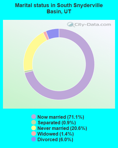
- Never married: 20.6%
- Now married: 71.1%
- Separated: 0.9%
- Widowed: 1.4%
- Divorced: 6.0%
For population 25 years and over in South Snyderville Basin:
- High school or higher: 96.5%
- Bachelor's degree or higher: 58.0%
- Graduate or professional degree: 21.2%
- Unemployed: 1.7%
- Mean travel time to work (commute): 25.5 minutes
| Here: | 8.3 |
| Utah average: | 10.5 |
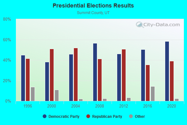

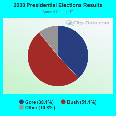
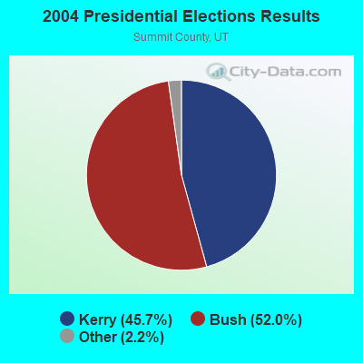

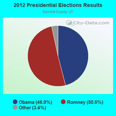
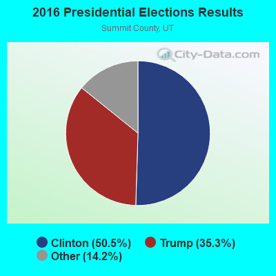
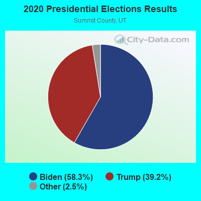
Graphs represent county-level data. Detailed 2008 Election Results
Religion statistics for South Snyderville Basin, UT (based on Summit County data)
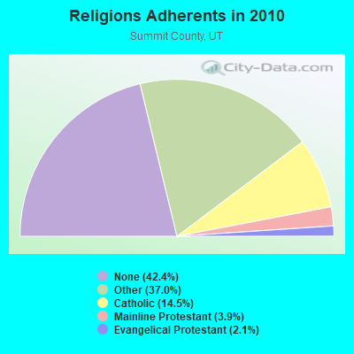
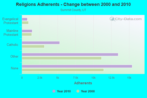
| Religion | Adherents | Congregations |
|---|---|---|
| Other | 13,448 | 34 |
| Catholic | 5,279 | 1 |
| Mainline Protestant | 1,429 | 3 |
| Evangelical Protestant | 751 | 7 |
| None | 15,417 | - |
Food Environment Statistics:
| Summit County: | 4.52 / 10,000 pop. |
| Utah: | 1.37 / 10,000 pop. |
| This county: | 1.41 / 10,000 pop. |
| Utah: | 0.41 / 10,000 pop. |
| This county: | 3.67 / 10,000 pop. |
| Utah: | 2.82 / 10,000 pop. |
| This county: | 23.46 / 10,000 pop. |
| Utah: | 5.09 / 10,000 pop. |
| Summit County: | 3.6% |
| State: | 6.3% |
| Summit County: | 12.9% |
| Utah: | 23.6% |
Strongest AM radio stations in South Snyderville Basin:
- KALL (700 AM; 50 kW; NORTH SALT LAKE CITY, UT; Owner: CITICASTERS LICENSES, L.P.)
- KIQN (1010 AM; 50 kW; TOOELE, UT)
- KSL (1160 AM; 50 kW; SALT LAKE CITY, UT; Owner: BONNEVILLE HOLDING COMPANY)
- KTKK (630 AM; 10 kW; SANDY, UT; Owner: UNITED BROADCASTING COMPANY)
- KBEE (860 AM; 10 kW; SALT LAKE CITY, UT; Owner: CITADEL BROADCASTING COMPANY)
- KNRS (570 AM; 5 kW; SALT LAKE CITY, UT; Owner: CITICASTERS LICENSES, L.P.)
- KZNS (1280 AM; 10 kW; SALT LAKE CITY, UT; Owner: SIMMONS-SLC, LS, LLC)
- KBJA (1640 AM; 10 kW; SANDY, UT; Owner: UNITED BROADCASTING COMPANY, INC)
- KLLB (1510 AM; daytime; 10 kW; WEST JORDAN, UT; Owner: UNITED SECURITY FINANCIAL, INC.)
- KKDS (1060 AM; 10 kW; SOUTH SALT LAKE, UT; Owner: HOLIDAY BROADCASTING COMPANY)
- KMRI (1550 AM; 10 kW; WEST VALLEY CITY, UT; Owner: KMRI RADIO, LLC)
- KFNZ (1320 AM; 5 kW; SALT LAKE CITY, UT; Owner: CITADEL BROADCASTING COMPANY)
- KSOP (1370 AM; 5 kW; SOUTH SALT LAKE, UT; Owner: KSOP, INC.)
Strongest FM radio stations in South Snyderville Basin:
- KPCW (91.9 FM; PARK CITY, UT; Owner: COMMUNITY WIRELESS OF PARK CITY, INC.)
- KBZN-FM1 (97.9 FM; PARK CITY, UT; Owner: CAPITOL BROADCASTING INC.)
- K201AE (88.1 FM; COALVILLE, ETC., UT; Owner: COMMUNITY WIRELESS OF PARK CITY, INC)
- KZHT-FM1 (94.9 FM; PARK CITY, UT; Owner: CITICASTERS LICENSES, L.P.)
- KCPX (105.7 FM; CENTERVILLE, UT; Owner: MERCURY BROADCASTING COMPANY, INC.)
- KCUA (92.5 FM; COALVILLE, UT; Owner: COMMUNITY WIRELESS OF PARK CITY, INC)
- KSOP-FM (104.3 FM; SALT LAKE CITY, UT; Owner: KSOP, INC.)
- K272DP (102.3 FM; TOOELE, UT; Owner: FAMILY STATIONS, INC.)
- KBZN (97.9 FM; OGDEN, UT; Owner: CAPITOL BROADCASTING, INC.)
- KRCL (90.9 FM; SALT LAKE CITY, UT; Owner: LISTENERS COMMUNITY RADIO OF UTAH)
- KBER (101.1 FM; OGDEN, UT; Owner: CITADEL BROADCASTING COMPANY)
- KISN-FM (97.1 FM; SALT LAKE CITY, UT; Owner: CLEAR CHANNEL BROADCASTING LICENSES, INC.)
- KKAT (101.9 FM; OGDEN, UT; Owner: CITICASTERS LICENSES, L.P.)
- KSFI (100.3 FM; SALT LAKE CITY, UT; Owner: SIMMONS-SLC, LS, LLC)
- KUBL-FM (93.3 FM; SALT LAKE CITY, UT; Owner: CITADEL BROADCASTING COMPANY)
- KOSY-FM (106.5 FM; SPANISH FORK, UT; Owner: MERCURY BROADCASTING COMPANY, INC.)
- KRSP-FM (103.5 FM; SALT LAKE CITY, UT; Owner: SIMMONS-SLC, LS, LLC)
- KXRK (96.3 FM; PROVO, UT; Owner: SIMMONS-SLC, LS, LLC)
- KQMB (102.7 FM; MIDVALE, UT; Owner: SIMMONS-SLC, LS, LLC)
- KODJ (94.1 FM; SALT LAKE CITY, UT; Owner: CITICASTERS LICENSES, L.P.)
TV broadcast stations around South Snyderville Basin:
- K27GD (Channel 27; PARK CITY, ETC., UT; Owner: SUMMIT COUNTY)
- K33FY (Channel 33; PARK CITY, UT; Owner: SUMMIT COUNTY)
- K15FL (Channel 15; PARK CITY, ECT., UT; Owner: SUMMIT COUNTY)
- K31FQ (Channel 31; PARK CITY, ETC., UT; Owner: SUMMIT COUNTY)
- K25DL (Channel 25; PARK CITY, UT; Owner: UNIVERSITY OF UTAH)
- K35OP (Channel 35; PARK CITY, UT; Owner: FOX TELEVISION STATIONS, INC.)
- K45AX (Channel 45; PARK CITY, UT; Owner: PARK CITY TELEVISION, LLC)
- KUTV (Channel 2; SALT LAKE CITY, UT; Owner: KUTV HOLDINGS, INC.)
- K59GS (Channel 59; SALT LAKE CITY, UT; Owner: ALPHA & OMEGA COMMUNICATIONS, LLC)
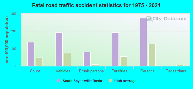
South Snyderville Basin fatal accident list:
Mar 28, 2016 07:51 PM, I-80, Lat: 40.724944, Lon: -111.537892, Vehicles: 2, Persons: 2, Fatalities: 1, Drunk persons involved: 1
Nov 8, 2008 02:30 AM, Us-40, Lat: 40.698080, Lon: -111.472440, Vehicles: 1, Persons: 2, Fatalities: 2, Drunk persons involved: 1
Apr 22, 2004 01:15 AM, I-80, Lat: 40.723097, Lon: -111.530517, Vehicles: 1, Persons: 2, Fatalities: 1
Apr 25, 1999 00:52 AM, I-80, Lat: 40.723097, Lon: -111.530517, Vehicles: 2, Persons: 3, Fatalities: 2, Drunk persons involved: 1
- National Bridge Inventory (NBI) Statistics
- 7Number of bridges
- 112ft / 34.0mTotal length
- 120,720Total average daily traffic
- 31,486Total average daily truck traffic
South Snyderville Basin compared to Utah state average:
- Median household income above state average.
- Median house value above state average.
- Unemployed percentage significantly below state average.
- Black race population percentage significantly below state average.
- Hispanic race population percentage significantly below state average.
- Median age above state average.
- Foreign-born population percentage significantly below state average.
- Renting percentage significantly below state average.
- Length of stay since moving in significantly above state average.
- Number of rooms per house significantly below state average.
- House age significantly below state average.
- Percentage of population with a bachelor's degree or higher significantly above state average.