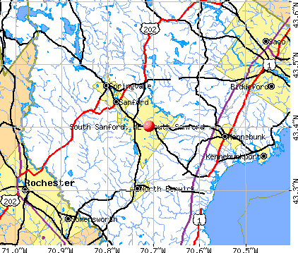
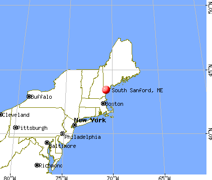
South Sanford, Maine
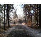
South Sanford: Ice Storm 08 South Sanford, starting to melt
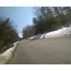
South Sanford: Horace Mills Rd/Gulliver Drive neighborhood
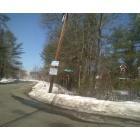
South Sanford: Corner of Horace Mills Rd/Country Club 3 Rd
- add
your
Submit your own pictures of this place and show them to the world
- OSM Map
- General Map
- Google Map
- MSN Map
Population change since 2000: +8.7%
| Males: 2,318 | |
| Females: 2,218 |
| Median resident age: | 45.7 years |
| Maine median age: | 45.1 years |
Zip codes: 04073.
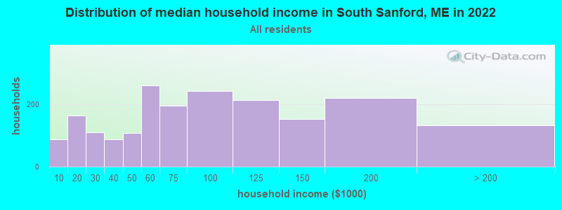
| South Sanford: | $76,804 |
| ME: | $69,543 |
Estimated per capita income in 2022: $35,632 (it was $17,515 in 2000)
South Sanford CDP income, earnings, and wages data
Estimated median house or condo value in 2022: $297,694 (it was $93,200 in 2000)
| South Sanford: | $297,694 |
| ME: | $290,600 |
Mean prices in 2022: all housing units: $451,552; detached houses: $470,451; townhouses or other attached units: $577,335; in 2-unit structures: $383,179; in 3-to-4-unit structures: $310,696; in 5-or-more-unit structures: $252,113; mobile homes: $105,501
Median gross rent in 2022: $1,168.
Detailed information about poverty and poor residents in South Sanford, ME


- 4,37394.2%White alone
- 932.0%Hispanic
- 521.1%Asian alone
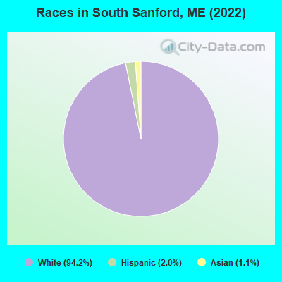
Races in South Sanford detailed stats: ancestries, foreign born residents, place of birth
 Recent articles from our blog. Our writers, many of them Ph.D. graduates or candidates, create easy-to-read articles on a wide variety of topics.

 | Casinos? (79 replies) |
Latest news from South Sanford, ME collected exclusively by city-data.com from local newspapers, TV, and radio stations
Ancestries: French Canadian (20.7%), Irish (13.2%), English (12.9%), American (11.8%), French (9.6%), Italian (6.2%).
Current Local Time: EST time zone
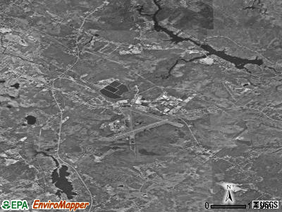
Elevation: 283 feet
Land area: 22.8 square miles.
Population density: 199 people per square mile (very low).
85 residents are foreign born
| This place: | 1.8% |
| Maine: | 100.0% |
Median real estate property taxes paid for housing units with mortgages in 2022: $3,601 (1.5%)
Median real estate property taxes paid for housing units with no mortgage in 2022: $3,277 (1.6%)
Nearest city with pop. 50,000+: Portland, ME  (28.6 miles , pop. 64,249).
Nearest city with pop. 200,000+: Boston, MA (77.2 miles , pop. 589,141).
Nearest city with pop. 1,000,000+: Bronx, NY (239.9 miles , pop. 1,332,650).
Nearest cities:
), ), Latitude: 43.40 N, Longitude: 70.71 W
Area code commonly used in this area: 207
| Here: | 3.1% |
| Maine: | 3.4% |
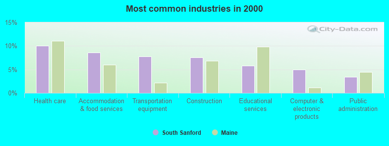
- Health care (10.0%)
- Accommodation & food services (8.6%)
- Transportation equipment (7.8%)
- Construction (7.5%)
- Educational services (5.8%)
- Computer & electronic products (5.0%)
- Public administration (3.4%)
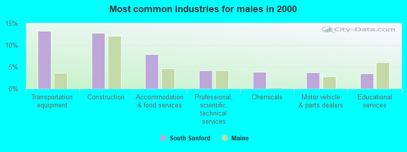
- Transportation equipment (13.3%)
- Construction (12.8%)
- Accommodation & food services (7.9%)
- Professional, scientific, technical services (4.2%)
- Chemicals (3.9%)
- Motor vehicle & parts dealers (3.7%)
- Educational services (3.5%)
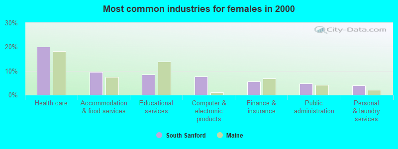
- Health care (20.1%)
- Accommodation & food services (9.5%)
- Educational services (8.5%)
- Computer & electronic products (7.7%)
- Finance & insurance (5.6%)
- Public administration (4.7%)
- Personal & laundry services (3.9%)
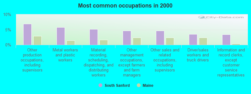
- Other production occupations, including supervisors (6.9%)
- Metal workers and plastic workers (5.8%)
- Material recording, scheduling, dispatching, and distributing workers (5.2%)
- Other management occupations, except farmers and farm managers (4.6%)
- Other sales and related occupations, including supervisors (4.6%)
- Driver/sales workers and truck drivers (3.5%)
- Information and record clerks, except customer service representatives (3.4%)
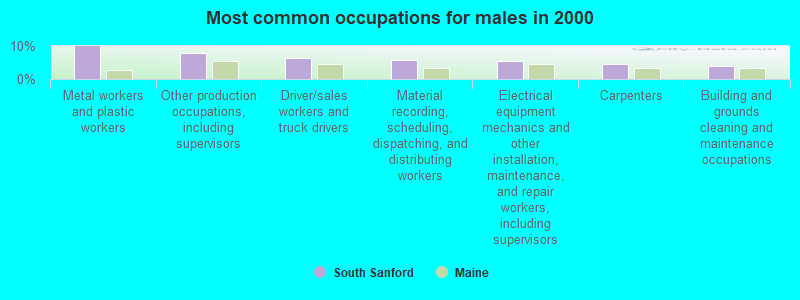
- Metal workers and plastic workers (10.0%)
- Other production occupations, including supervisors (7.8%)
- Driver/sales workers and truck drivers (6.4%)
- Material recording, scheduling, dispatching, and distributing workers (5.6%)
- Electrical equipment mechanics and other installation, maintenance, and repair workers, including supervisors (5.6%)
- Carpenters (4.4%)
- Building and grounds cleaning and maintenance occupations (4.0%)
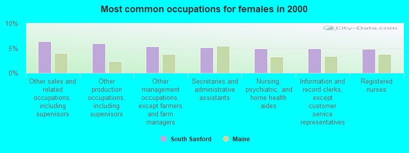
- Other sales and related occupations, including supervisors (6.4%)
- Other production occupations, including supervisors (5.9%)
- Other management occupations, except farmers and farm managers (5.4%)
- Secretaries and administrative assistants (5.2%)
- Nursing, psychiatric, and home health aides (5.0%)
- Information and record clerks, except customer service representatives (5.0%)
- Registered nurses (4.9%)
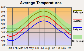
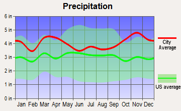
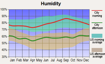
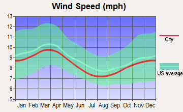
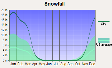
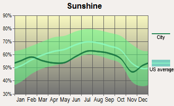
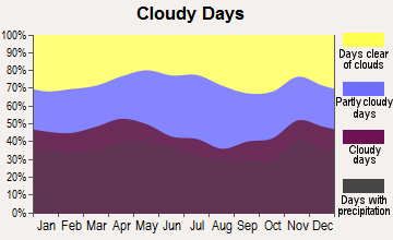
Average climate in South Sanford, Maine
Based on data reported by over 4,000 weather stations
(lower is better)
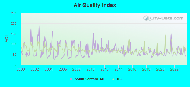
Air Quality Index (AQI) level in 2023 was 54.6. This is better than average.
| City: | 54.6 |
| U.S.: | 72.6 |
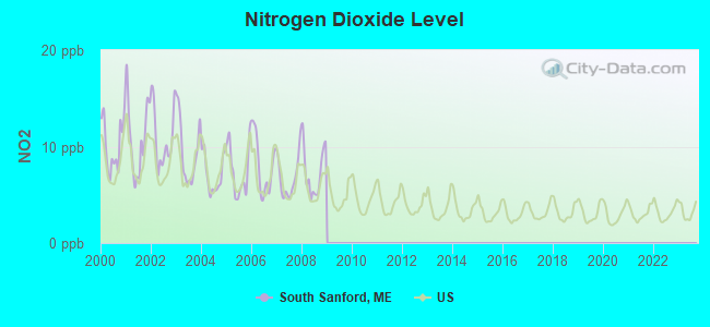
Nitrogen Dioxide (NO2) [ppb] level in 2008 was 7.38. This is significantly worse than average. Closest monitor was 12.7 miles away from the city center.
| City: | 7.38 |
| U.S.: | 5.11 |
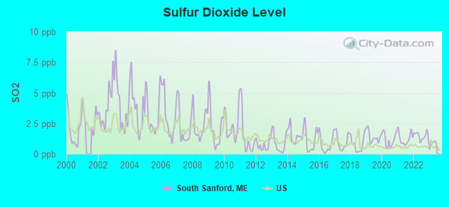
Sulfur Dioxide (SO2) [ppb] level in 2022 was 1.48. This is about average. Closest monitor was 4.3 miles away from the city center.
| City: | 1.48 |
| U.S.: | 1.51 |
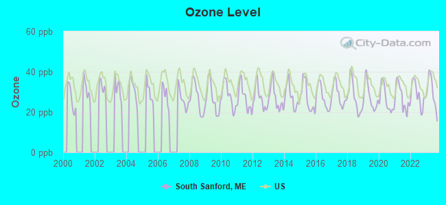
Ozone [ppb] level in 2023 was 29.8. This is about average. Closest monitor was 8.4 miles away from the city center.
| City: | 29.8 |
| U.S.: | 33.3 |
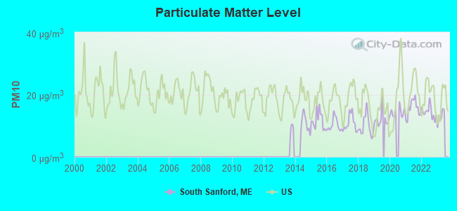
Particulate Matter (PM10) [µg/m3] level in 2022 was 14.4. This is better than average. Closest monitor was 14.1 miles away from the city center.
| City: | 14.4 |
| U.S.: | 19.2 |
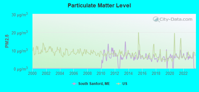
Particulate Matter (PM2.5) [µg/m3] level in 2022 was 6.41. This is better than average. Closest monitor was 14.9 miles away from the city center.
| City: | 6.41 |
| U.S.: | 8.11 |
Tornado activity:
South Sanford-area historical tornado activity is significantly above Maine state average. It is 66% smaller than the overall U.S. average.
On 6/9/1953, a category F3 (max. wind speeds 158-206 mph) tornado 32.6 miles away from the South Sanford place center injured 5 people and caused between $5000 and $50,000 in damages.
On 10/10/1966, a category F2 (max. wind speeds 113-157 mph) tornado 4.0 miles away from the place center caused between $5000 and $50,000 in damages.
Earthquake activity:
South Sanford-area historical earthquake activity is significantly above Maine state average. It is 73% smaller than the overall U.S. average.On 10/16/2012 at 23:12:25, a magnitude 4.7 (4.7 ML, Depth: 10.0 mi, Class: Light, Intensity: IV - V) earthquake occurred 13.8 miles away from South Sanford center
On 4/20/2002 at 10:50:47, a magnitude 5.3 (5.3 ML, Depth: 3.0 mi, Class: Moderate, Intensity: VI - VII) earthquake occurred 167.4 miles away from South Sanford center
On 1/19/1982 at 00:14:42, a magnitude 4.7 (4.5 MB, 4.7 MD, 4.5 LG) earthquake occurred 45.2 miles away from South Sanford center
On 10/7/1983 at 10:18:46, a magnitude 5.3 (5.1 MB, 5.3 LG, 5.1 ML) earthquake occurred 185.6 miles away from South Sanford center
On 4/20/2002 at 10:50:47, a magnitude 5.2 (5.2 MB, 4.2 MS, 5.2 MW, 5.0 MW) earthquake occurred 167.5 miles away from South Sanford center
On 8/21/1996 at 07:54:14, a magnitude 3.8 (3.8 LG, 3.6 LG, Depth: 6.2 mi, Class: Light, Intensity: II - III) earthquake occurred 62.9 miles away from the city center
Magnitude types: regional Lg-wave magnitude (LG), body-wave magnitude (MB), duration magnitude (MD), local magnitude (ML), surface-wave magnitude (MS), moment magnitude (MW)
Natural disasters:
The number of natural disasters in York County (31) is a lot greater than the US average (15).Major Disasters (Presidential) Declared: 23
Emergencies Declared: 8
Causes of natural disasters: Floods: 21, Storms: 16, Winter Storms: 6, Snows: 5, Winds: 3, Heavy Rains: 2, Hurricanes: 2, Blizzard: 1, Ice Storm: 1, Mudslide: 1, Snowfall: 1, Snowstorm: 1, Tornado: 1, Tropical Storm: 1 (Note: some incidents may be assigned to more than one category).
Hospitals and medical centers near South Sanford:
- SANFORD HEALTH CARE FACILITY (Nursing Home, about 1 miles away; SANFORD, ME)
- GREENWOOD CENTER (Nursing Home, about 2 miles away; SANFORD, ME)
- MAINE STAY NURSING HOME (Nursing Home, about 2 miles away; SANFORD, ME)
- VARNEY CROSSING NCC (Nursing Home, about 8 miles away; NORTH BERWICK, ME)
- KINDRED TRANSITIONAL CARE AND REHAB-KENNEBUNK (Nursing Home, about 8 miles away; KENNEBUNK, ME)
- SOUTHERN MAINE MEDICAL CENTER Acute Care Hospitals (about 13 miles away; BIDDEFORD, ME)
- TRI-AREA VNA - HOSPICE (Hospital, about 14 miles away; SOMERSWORTH, NH)
Colleges/universities with over 2000 students nearest to South Sanford:
- University of New England (about 17 miles; Biddeford, ME; Full-time enrollment: 4,539)
- University of New Hampshire-Main Campus (about 22 miles; Durham, NH; FT enrollment: 15,243)
- University of Southern Maine (about 29 miles; Portland, ME; FT enrollment: 6,647)
- Southern Maine Community College (about 30 miles; South Portland, ME; FT enrollment: 4,666)
- Saint Joseph's College of Maine (about 32 miles; Standish, ME; FT enrollment: 2,010)
- NHTI-Concord's Community College (about 44 miles; Concord, NH; FT enrollment: 2,865)
- Southern New Hampshire University (about 46 miles; Manchester, NH; FT enrollment: 16,552)
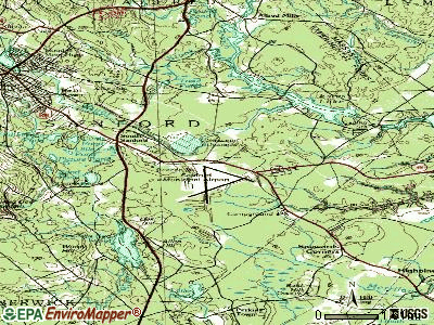
Points of interest:
Notable locations in South Sanford: South Sanford Industrial Area (A), Sanford Country Club (B), Sanford Speedway (C), Sanford Fire Department South Sanford Station (D). Display/hide their locations on the map
Shopping Center: The Center for Shopping Shopping Center (1). Display/hide its location on the map
Lakes and reservoirs: Curtis Pond (A), Little Long Pond (B), Little Pond (C), Mud Pond (D), Old Fishing Pond (E), Picture Pond (F), Pond-in-the-River (G), Round Pond (H). Display/hide their locations on the map
Streams, rivers, and creeks: Canes Brook (A), Middle Branch Mousam River (B), Perkins Marsh Brook (C), Hay Brook (D). Display/hide their locations on the map
| This place: | 2.4 people |
| Maine: | 2.3 people |
| This place: | 66.2% |
| Whole state: | 62.9% |
| This place: | 9.4% |
| Whole state: | 9.4% |
Likely homosexual households (counted as self-reported same-sex unmarried-partner households)
- Lesbian couples: 0.2% of all households
- Gay men: 0.2% of all households
3 people in residential treatment centers for adults in 2010
4 people in homes for the mentally retarded in 2000
For population 15 years and over in South Sanford:
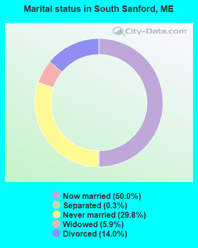
- Never married: 29.8%
- Now married: 50.0%
- Separated: 0.3%
- Widowed: 5.9%
- Divorced: 14.0%
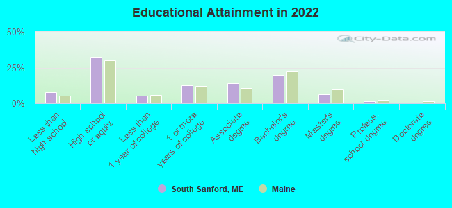
For population 25 years and over in South Sanford:
- High school or higher: 86.8%
- Bachelor's degree or higher: 22.4%
- Graduate or professional degree: 6.5%
- Unemployed: 3.2%
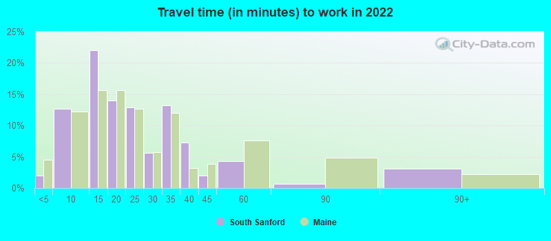
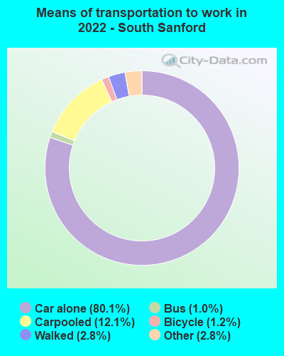
- Mean travel time to work (commute): 29.4 minutes
| Here: | 9.5 |
| Maine average: | 10.3 |


Graphs represent county-level data. Detailed 2008 Election Results
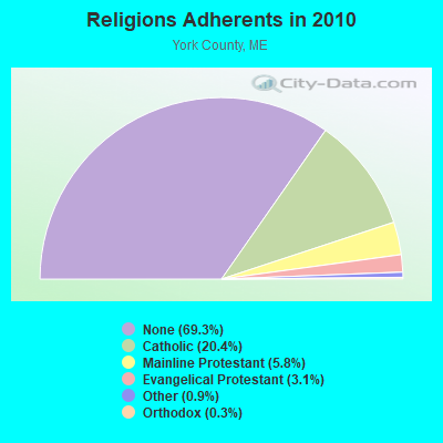
Religion statistics for South Sanford, ME (based on York County data)

| Religion | Adherents | Congregations |
|---|---|---|
| Catholic | 40,283 | 16 |
| Mainline Protestant | 11,480 | 64 |
| Evangelical Protestant | 6,086 | 51 |
| Other | 1,847 | 18 |
| Orthodox | 625 | 3 |
| Black Protestant | 119 | 1 |
| None | 136,691 | - |
Food Environment Statistics:
| Here: | 2.24 / 10,000 pop. |
| Maine: | 2.80 / 10,000 pop. |
| This county: | 0.05 / 10,000 pop. |
| State: | 0.14 / 10,000 pop. |
| This county: | 2.09 / 10,000 pop. |
| Maine: | 2.20 / 10,000 pop. |
| York County: | 4.23 / 10,000 pop. |
| State: | 5.75 / 10,000 pop. |
| York County: | 12.53 / 10,000 pop. |
| Maine: | 11.02 / 10,000 pop. |
| Here: | 7.7% |
| Maine: | 8.2% |
| York County: | 24.0% |
| State: | 25.0% |
Strongest AM radio stations in South Sanford:
- WPHX (1220 AM; 1 kW; SANFORD, ME; Owner: FNX BROADCASTING L.L.C.)
- WGIN (930 AM; 10 kW; ROCHESTER, NH; Owner: CAPSTAR TX LIMITED PARTNERSHIP)
- WMTW (870 AM; 10 kW; GORHAM, ME; Owner: RADIO PARTNERS OF MAINE, L.P.)
- WRKO (680 AM; 50 kW; BOSTON, MA; Owner: ENTERCOM BOSTON LICENSE, LLC)
- WTSN (1270 AM; 5 kW; DOVER, NH; Owner: GARRISON CITY BROADCASTING, INC.)
- WGAN (560 AM; 5 kW; PORTLAND, ME; Owner: SAGA COMMUNICATIONS OF NEW ENGLAND, LLC)
- WZAN (970 AM; 5 kW; PORTLAND, ME; Owner: SAGA COMMUNICATIONS OF NEW ENGLAND, LLC)
- WEEI (850 AM; 50 kW; BOSTON, MA; Owner: ENTERCOM BOSTON LICENSE, LLC)
- WBZ (1030 AM; 50 kW; BOSTON, MA; Owner: INFINITY BROADCASTING OPERATIONS, INC.)
- WWZN (1510 AM; 50 kW; BOSTON, MA; Owner: ROSE CITY RADIO CORPORATION)
- WKOX (1200 AM; 50 kW; FRAMINGHAM, MA; Owner: CAPSTAR TX LIMITED PARTNERSHIP)
- WCRN (830 AM; 50 kW; WORCESTER, MA; Owner: CARTER BROADCASTING CORPORATION)
- WJAE (1440 AM; 5 kW; WESTBROOK, ME; Owner: ALTANTIC COAST RADIO, LLC)
Strongest FM radio stations in South Sanford:
- WPHX-FM (92.1 FM; SANFORD, ME; Owner: FNX BROADCASTING LLC)
- WSEW (88.5 FM; SANFORD, ME; Owner: WORD RADIO EDUCATIONAL FOUNDATION)
- WUBB (95.3 FM; YORK CENTER, ME; Owner: CAPSTAR TX LIMITED PARTNERSHIP)
- WMEA (90.1 FM; PORTLAND, ME; Owner: MAINE PUBLIC BROADCASTING CORPORATION)
- WSCY (106.9 FM; MOULTONBOROUGH, NH; Owner: NORTHEAST COMMUNICATIONS CORPORATION)
- WPKQ (103.7 FM; NORTH CONWAY, NH; Owner: CITADEL BROADCASTING COMPANY)
- WHOM (94.9 FM; MT. WASHINGTON, NH; Owner: CITADEL BROADCASTING COMPANY)
- WBLM (102.9 FM; PORTLAND, ME; Owner: CITADEL BROADCASTING COMPANY)
- WMEX (106.5 FM; FARMINGTON, NH; Owner: WIMMEX, LLC)
- WQEZ (104.7 FM; KENNEBUNKPORT, ME; Owner: MARINER BROADCASTING L.P.)
- WOKQ (97.5 FM; DOVER, NH; Owner: CITADEL BROADCASTING COMPANY)
- WCYY (94.3 FM; BIDDEFORD, ME; Owner: CITADEL BROADCASTING COMPANY)
- WBQQ (99.3 FM; KENNEBUNK, ME; Owner: MARINER BROADCASTING L.P.)
- WQSO (96.7 FM; ROCHESTER, NH; Owner: CAPSTAR TX LIMITED PARTNERSHIP)
- WRED (95.9 FM; SACO, ME; Owner: ATLANTIC COAST RADIO, LLC)
- WLKZ (104.9 FM; WOLFEBORO, NH; Owner: TELE-MEDIA COMPANY OF NEW HAMPSHIRE, L.L.C.)
- WSHK (105.3 FM; KITTERY, ME; Owner: CITADEL BROADCASTING COMPANY)
- WVFM (105.7 FM; CAMPTON, NH; Owner: DEVON BROADCASTING COMPANY, INC.)
- WBYY (98.7 FM; SOMERSWORTH, NH; Owner: GARRISON CITY BROADCASTING, INC.)
- WJBQ (97.9 FM; PORTLAND, ME; Owner: CITADEL BROADCASTING COMPANY)
TV broadcast stations around South Sanford:
- WMEA-TV (Channel 26; BIDDEFORD, ME; Owner: MAINE PUBLIC BROADCASTING CORP.)
- WMTW-TV (Channel 8; POLAND SPRING, ME; Owner: WMTW BROADCAST GROUP, LLC)
- WCSH (Channel 6; PORTLAND, ME; Owner: PACIFIC AND SOUTHERN COMPANY, INC.)
- WGME-TV (Channel 13; PORTLAND, ME; Owner: WGME LICENSEE, LLC)
- WHDN-LP (Channel 26; BOSTON, MA; Owner: GUENTER MARKSTEINER)
- WPXT (Channel 51; PORTLAND, ME; Owner: HMW, INC.)
- National Bridge Inventory (NBI) Statistics
- 9Number of bridges
- 82ft / 25.2mTotal length
- 21,992Total average daily traffic
- 1,096Total average daily truck traffic
- 37,628Total future (year 2034) average daily traffic
FCC Registered Microwave Towers:
1- LION HILL, Lion Hill (Lat: 43.398472 Lon: -70.718972), Type: Ltower, Structure height: 11 m, Call Sign: WRBZ486,
Assigned Frequencies: 941.750 MHz, Grant Date: 08/02/2018, Expiration Date: 08/02/2028, Certifier: William Tower, Registrant: Southern Maine Communications, 9 Kostis Lane, Sanford, ME 04073, Phone: (207) 324-6755, Fax: (207) 324-6766, Email:
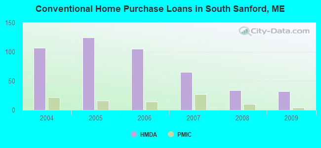
| Home Mortgage Disclosure Act Aggregated Statistics For Year 2009 (Based on 1 full and 1 partial tracts) | ||||||||||||||
| A) FHA, FSA/RHS & VA Home Purchase Loans | B) Conventional Home Purchase Loans | C) Refinancings | D) Home Improvement Loans | E) Loans on Dwellings For 5+ Families | F) Non-occupant Loans on < 5 Family Dwellings (A B C & D) | G) Loans On Manufactured Home Dwelling (A B C & D) | ||||||||
|---|---|---|---|---|---|---|---|---|---|---|---|---|---|---|
| Number | Average Value | Number | Average Value | Number | Average Value | Number | Average Value | Number | Average Value | Number | Average Value | Number | Average Value | |
| LOANS ORIGINATED | 37 | $168,022 | 32 | $120,425 | 111 | $137,171 | 20 | $60,090 | 1 | $1,020,240 | 7 | $106,497 | 7 | $57,857 |
| APPLICATIONS APPROVED, NOT ACCEPTED | 3 | $157,310 | 3 | $113,733 | 14 | $140,210 | 3 | $21,743 | 0 | $0 | 1 | $128,150 | 3 | $19,667 |
| APPLICATIONS DENIED | 5 | $145,576 | 6 | $104,800 | 63 | $167,250 | 8 | $63,111 | 0 | $0 | 4 | $155,998 | 7 | $70,857 |
| APPLICATIONS WITHDRAWN | 3 | $155,200 | 2 | $175,490 | 22 | $181,493 | 0 | $0 | 0 | $0 | 1 | $320,000 | 1 | $123,160 |
| FILES CLOSED FOR INCOMPLETENESS | 0 | $0 | 0 | $0 | 1 | $170,260 | 1 | $34,690 | 0 | $0 | 0 | $0 | 0 | $0 |
Detailed HMDA statistics for the following Tracts: 0302.03 , 0303.00
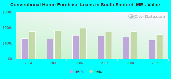
| Private Mortgage Insurance Companies Aggregated Statistics For Year 2009 (Based on 1 full and 1 partial tracts) | ||||
| A) Conventional Home Purchase Loans | B) Refinancings | |||
|---|---|---|---|---|
| Number | Average Value | Number | Average Value | |
| LOANS ORIGINATED | 4 | $155,422 | 4 | $199,828 |
| APPLICATIONS APPROVED, NOT ACCEPTED | 0 | $0 | 0 | $0 |
| APPLICATIONS DENIED | 0 | $0 | 1 | $160,000 |
| APPLICATIONS WITHDRAWN | 0 | $0 | 0 | $0 |
| FILES CLOSED FOR INCOMPLETENESS | 0 | $0 | 0 | $0 |
Detailed PMIC statistics for the following Tracts: 0302.03 , 0303.00
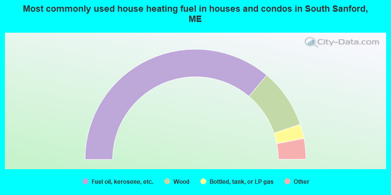
- 72.4%Fuel oil, kerosene, etc.
- 17.4%Wood
- 4.2%Bottled, tank, or LP gas
- 1.8%Electricity
- 1.2%Other fuel
- 1.1%Utility gas
- 1.0%No fuel used
- 0.9%Coal or coke
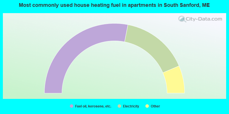
- 56.4%Fuel oil, kerosene, etc.
- 31.2%Electricity
- 3.8%Bottled, tank, or LP gas
- 3.8%Other fuel
- 2.7%No fuel used
- 2.2%Utility gas
South Sanford compared to Maine state average:
- Unemployed percentage significantly below state average.
- Black race population percentage significantly below state average.
- Foreign-born population percentage below state average.
- Length of stay since moving in significantly above state average.
- House age significantly below state average.