South Flat, Wyoming
Submit your own pictures of this place and show them to the world
- OSM Map
- General Map
- Google Map
- MSN Map

| Males: 183 | |
| Females: 170 |
| Median resident age: | 37.6 years |
| Wyoming median age: | 36.2 years |
Zip codes: 82401.
| South Flat: | $69,896 |
| WY: | $70,042 |
Estimated per capita income in 2022: $26,266 (it was $14,693 in 2000)
South Flat CDP income, earnings, and wages data
Estimated median house or condo value in 2022: $247,619 (it was $95,700 in 2000)
| South Flat: | $247,619 |
| WY: | $292,300 |
Detailed information about poverty and poor residents in South Flat, WY


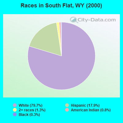
- 29879.7%White alone
- 6717.9%Hispanic
- 51.3%Two or more races
- 30.8%American Indian alone
- 10.3%Black alone
Races in South Flat detailed stats: ancestries, foreign born residents, place of birth
 Recent articles from our blog. Our writers, many of them Ph.D. graduates or candidates, create easy-to-read articles on a wide variety of topics.

 | Pumpkin patch in Worland? (2 replies) |
Latest news from South Flat, WY collected exclusively by city-data.com from local newspapers, TV, and radio stations
Ancestries: German (40.9%), Irish (21.4%), English (13.9%), Scottish (6.7%), Scotch-Irish (5.3%), United States (4.5%).
Current Local Time: MST time zone
Land area: 21.7 square miles.
Population density: 16 people per square mile (very low).
18 residents are foreign born (4.8% Latin America).
| This place: | 4.8% |
| Wyoming: | 2.3% |
| South Flat CDP: | 0.7% ($700) |
| Wyoming: | 0.7% ($627) |
Nearest city with pop. 50,000+: Billings, MT  (130.9 miles , pop. 89,847).
Nearest city with pop. 200,000+: West Adams, CO (320.9 miles , pop. 259,628).
Nearest city with pop. 1,000,000+: Phoenix, AZ (751.8 miles , pop. 1,321,045).
Nearest cities:
), ), ), ), ), Latitude: 43.93 N, Longitude: 108.02 W
Area code commonly used in this area: 307
| Here: | 2.6% |
| Wyoming: | 2.5% |
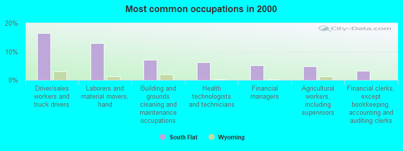
- Driver/sales workers and truck drivers (16.5%)
- Laborers and material movers, hand (12.9%)
- Building and grounds cleaning and maintenance occupations (7.1%)
- Health technologists and technicians (6.3%)
- Financial managers (5.1%)
- Agricultural workers, including supervisors (4.7%)
- Financial clerks, except bookkeeping, accounting and auditing clerks (3.1%)
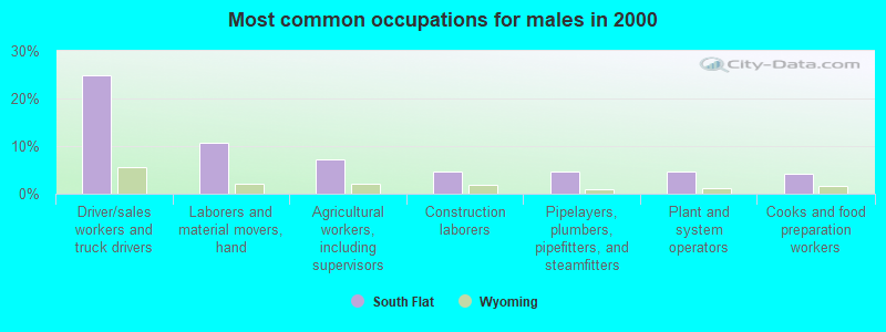
- Driver/sales workers and truck drivers (25.0%)
- Laborers and material movers, hand (10.7%)
- Agricultural workers, including supervisors (7.1%)
- Construction laborers (4.8%)
- Pipelayers, plumbers, pipefitters, and steamfitters (4.8%)
- Plant and system operators (4.8%)
- Cooks and food preparation workers (4.2%)
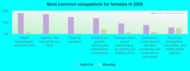
- Health technologists and technicians (18.4%)
- Laborers and material movers, hand (17.2%)
- Financial managers (14.9%)
- Building and grounds cleaning and maintenance occupations (13.8%)
- Financial clerks, except bookkeeping, accounting and auditing clerks (9.2%)
- Counselors, social workers, and other community and social service specialists (8.0%)
- Preschool, kindergarten, elementary, and middle school teachers (5.7%)
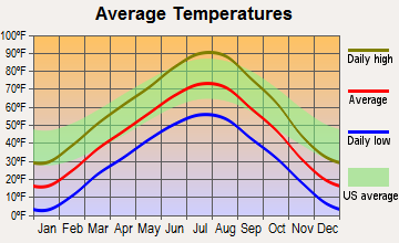
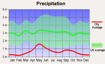
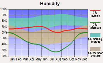
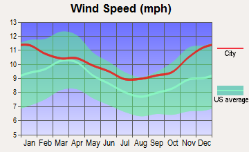
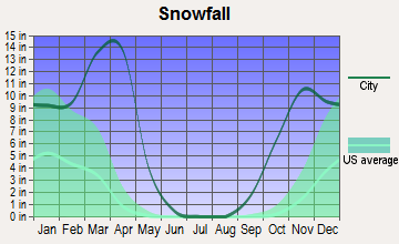
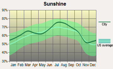
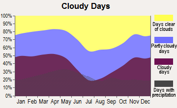
Average climate in South Flat, Wyoming
Based on data reported by over 4,000 weather stations
(lower is better)
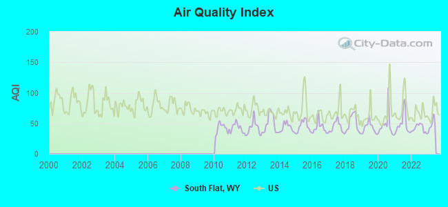
Air Quality Index (AQI) level in 2022 was 42.1. This is significantly better than average.
| City: | 42.1 |
| U.S.: | 72.6 |
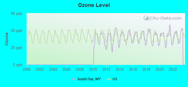
Ozone [ppb] level in 2022 was 31.9. This is about average. Closest monitor was 24.2 miles away from the city center.
| City: | 31.9 |
| U.S.: | 33.3 |
Earthquake activity:
South Flat-area historical earthquake activity is significantly above Wyoming state average. It is 965% greater than the overall U.S. average.On 8/18/1959 at 06:37:13, a magnitude 7.7 (7.7 UK, Class: Major, Intensity: VIII - XII) earthquake occurred 137.7 miles away from South Flat center, causing $26,000,000 total damage
On 10/28/1983 at 14:06:06, a magnitude 7.3 (6.2 MB, 7.3 MS, 7.0 MW) earthquake occurred 287.8 miles away from the city center, causing 2 deaths (2 shaking deaths) and 3 injuries, causing $15,000,000 total damage
On 6/30/1975 at 18:54:13, a magnitude 6.1 (5.6 MB, 5.9 MS, 6.1 UK, 6.1 ML, Class: Strong, Intensity: VII - IX) earthquake occurred 144.0 miles away from South Flat center
On 2/3/1994 at 09:05:04, a magnitude 5.8 (5.4 MB, 5.5 MS, 5.8 MW, 5.8 ML, Depth: 4.9 mi, Class: Moderate, Intensity: VI - VII) earthquake occurred 168.2 miles away from the city center
On 3/28/1975 at 02:31:05, a magnitude 6.2 (6.1 MB, 6.0 MS, 6.2 ML) earthquake occurred 261.5 miles away from the city center
On 10/3/1915 at 06:52:48, a magnitude 7.6 (7.6 UK) earthquake occurred 540.0 miles away from the city center
Magnitude types: body-wave magnitude (MB), local magnitude (ML), surface-wave magnitude (MS), moment magnitude (MW)
Natural disasters:
The number of natural disasters in Washakie County (4) is a lot smaller than the US average (15).Major Disasters (Presidential) Declared: 2
Causes of natural disasters: Floods: 3, Storms: 2, Landslide: 1, Mudslide: 1, Other: 1 (Note: some incidents may be assigned to more than one category).
Colleges/universities with over 2000 students nearest to South Flat:
- Sheridan College (about 79 miles; Sheridan, WY; Full-time enrollment: 2,070)
- Casper College (about 115 miles; Casper, WY; FT enrollment: 2,770)
- Montana State University-Billings (about 132 miles; Billings, MT; FT enrollment: 4,319)
- Western Wyoming Community College (about 174 miles; Rock Springs, WY; FT enrollment: 2,086)
- Brigham Young University-Idaho (about 188 miles; Rexburg, ID; FT enrollment: 30,522)
- Montana State University (about 192 miles; Bozeman, MT; FT enrollment: 12,942)
- Black Hills State University (about 210 miles; Spearfish, SD; FT enrollment: 3,166)
Points of interest:
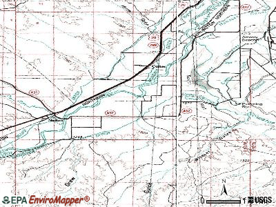
Creek: Nowater Creek (A). Display/hide its location on the map
| This place: | 2.8 people |
| Wyoming: | 2.5 people |
| This place: | 82.0% |
| Whole state: | 67.9% |
| This place: | 3.8% |
| Whole state: | 5.4% |
No gay or lesbian households reported
| This place: | 7.7% |
| Whole state: | 11.4% |
| This place: | 0.4% |
| Whole state: | 4.5% |
For population 15 years and over in South Flat:
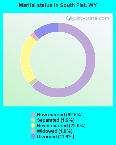
- Never married: 22.0%
- Now married: 62.5%
- Separated: 1.9%
- Widowed: 1.9%
- Divorced: 11.6%
For population 25 years and over in South Flat:
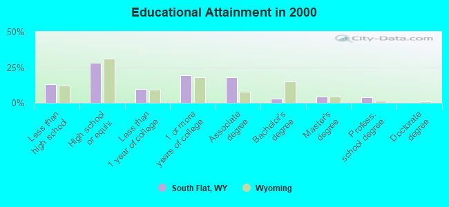
- High school or higher: 86.8%
- Bachelor's degree or higher: 11.3%
- Graduate or professional degree: 8.3%
- Unemployed: 8.9%
- Mean travel time to work (commute): 10.1 minutes
| Here: | 10.2 |
| Wyoming average: | 10.0 |
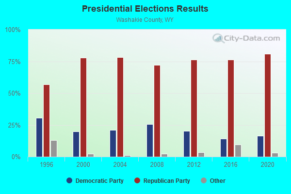
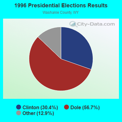
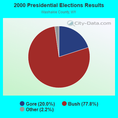

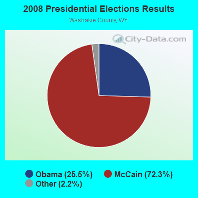
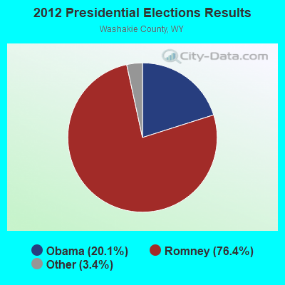
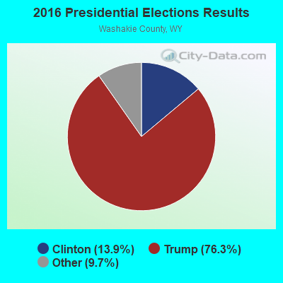
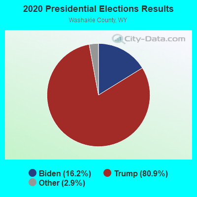
Graphs represent county-level data. Detailed 2008 Election Results
Religion statistics for South Flat, WY (based on Washakie County data)
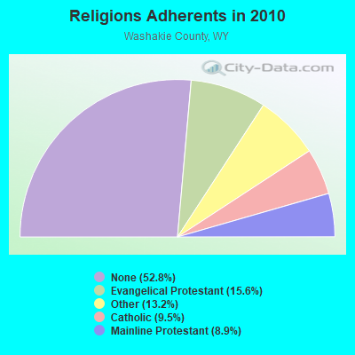
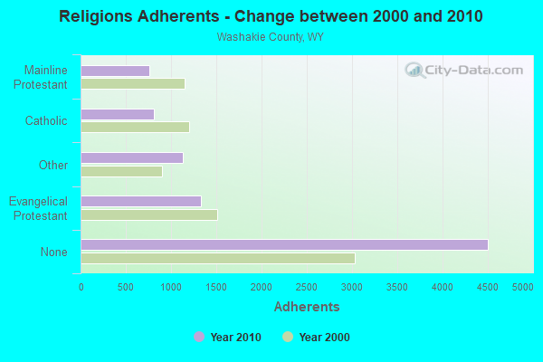
| Religion | Adherents | Congregations |
|---|---|---|
| Evangelical Protestant | 1,330 | 15 |
| Other | 1,130 | 4 |
| Catholic | 809 | 1 |
| Mainline Protestant | 757 | 5 |
| Orthodox | - | - |
| None | 4,507 | - |
Food Environment Statistics:
| Here: | 3.84 / 10,000 pop. |
| Wyoming: | 2.10 / 10,000 pop. |
| This county: | 6.40 / 10,000 pop. |
| State: | 5.36 / 10,000 pop. |
| This county: | 19.19 / 10,000 pop. |
| State: | 10.08 / 10,000 pop. |
| This county: | 10.7% |
| Wyoming: | 7.1% |
| Washakie County: | 23.9% |
| Wyoming: | 24.4% |
Strongest AM radio stations in South Flat:
- KWOR (1340 AM; 1 kW; WORLAND, WY; Owner: KWOR, INCORPORATED)
- KZMQ (1140 AM; daytime; 10 kW; GREYBULL, WY; Owner: LEGEND COMMUNICATIONS OF WYOMING LLC)
- KTWO (1030 AM; 50 kW; CASPER, WY; Owner: CITICASTERS LICENSES, L.P.)
- KUYO (830 AM; daytime; 25 kW; EVANSVILLE, WY; Owner: WYOMING CHRISTIAN BROADCASTING COMPANY)
- KTHE (1240 AM; 1 kW; THERMOPOLIS, WY; Owner: CARJIM, LLC)
- KPOW (1260 AM; 5 kW; POWELL, WY; Owner: CHAPARRAL BROADCASTING, INC.)
- KROE (930 AM; 5 kW; SHERIDAN, WY; Owner: LOVCOM, INC.)
- KALL (700 AM; 50 kW; NORTH SALT LAKE CITY, UT; Owner: CITICASTERS LICENSES, L.P.)
- KLTT (670 AM; 50 kW; COMMERCE CITY, CO; Owner: KLZ RADIO, INC.)
- KKZN (760 AM; 50 kW; THORNTON, CO; Owner: JACOR BROADCASTING OF COLORADO, INC.)
- KWYO (1410 AM; 5 kW; SHERIDAN, WY; Owner: KWYO AM, LLC)
- KBHB (810 AM; 25 kW; STURGIS, SD; Owner: MONTEREY LICENSES, LLC)
- KIQN (1010 AM; 50 kW; TOOELE, UT)
Strongest FM radio stations in South Flat:
- KWYW (99.1 FM; LOST CABIN, WY; Owner: JIMMY RAY CARROLL)
- KDNO (101.7 FM; THERMOPOLIS, WY; Owner: CARJIM, LLC)
- KWRR (89.5 FM; ETHETE, WY; Owner: BUSINESS COUNCIL OF THE NORTHERN ARAPAHO TRIBE)
- K273AD (102.5 FM; WORLAND, WY; Owner: WESTERN INSPIRATIONAL B/CASTING, INC)
- KKLX (96.1 FM; WORLAND, WY; Owner: KWOR, INCORPORATED)
- K244CK (96.7 FM; COWLEY, ETC., WY; Owner: CONNECTION COMMUNICATIONS ASSOC., INC.)
- KZMQ-FM (100.3 FM; GREYBULL, WY; Owner: LEGEND COMMUNICATIONS OF WYOMING LLC)
- KUWT (91.3 FM; THERMOPOLIS, WY; Owner: UNIVERSITY OF WYOMING)
TV broadcast stations around South Flat:
- K04DZ (Channel 4; WORLAND, WY; Owner: WORLAND ANTENNA TV, INC)
- K12BK (Channel 12; WORLAND, WY; Owner: WORLAND ANTENNA TV, INC)
South Flat fatal accident list:
Dec 17, 2006 01:17 PM, Sr-432, Lat: 43.973570, Lon: -107.991830, Vehicles: 1, Persons: 1, Fatalities: 1
Apr 3, 2005 01:25 PM, Sr-432, Lat: 43.968780, Lon: -107.992250, Vehicles: 1, Persons: 1, Fatalities: 1
- National Bridge Inventory (NBI) Statistics
- 6Number of bridges
- 66ft / 20.0mTotal length
- $40,000Total costs
- 2,226Total average daily traffic
- 114Total average daily truck traffic
- 3,117Total future (year 2041) average daily traffic
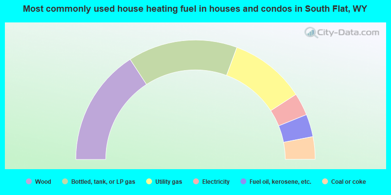
- 31.6%Wood
- 29.6%Bottled, tank, or LP gas
- 20.4%Utility gas
- 6.1%Electricity
- 6.1%Fuel oil, kerosene, etc.
- 6.1%Coal or coke
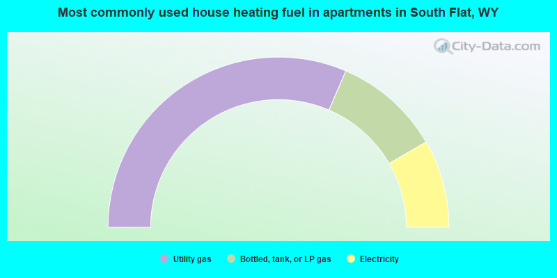
- 63.0%Utility gas
- 20.4%Bottled, tank, or LP gas
- 16.7%Electricity
South Flat compared to Wyoming state average:
- Unemployed percentage below state average.
- Black race population percentage below state average.
- Median age below state average.
- Renting percentage significantly below state average.
- Length of stay since moving in significantly above state average.
- Number of rooms per house significantly below state average.
- House age significantly below state average.
- Number of college students significantly below state average.
- Percentage of population with a bachelor's degree or higher below state average.