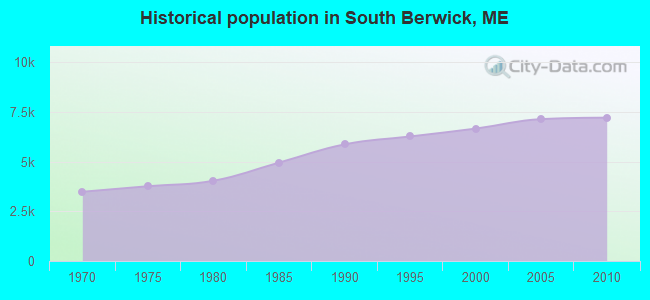
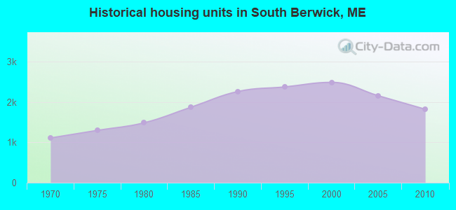
South Berwick, Maine
Submit your own pictures of this town and show them to the world
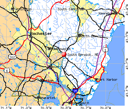
- OSM Map
- General Map
- Google Map
- MSN Map
Population change since 2000: +8.2%
 |
| Males: 3,564 | |
| Females: 3,656 |
| Median resident age: | 40.5 years |
| Maine median age: | 43.0 years |
Zip codes: 03908.
| South Berwick: | $99,900 |
| ME: | $69,543 |
Estimated per capita income in 2022: $42,962 (it was $21,118 in 2000)
South Berwick town income, earnings, and wages data
Estimated median house or condo value in 2022: $415,238 (it was $130,000 in 2000)
| South Berwick: | $415,238 |
| ME: | $290,600 |
Mean prices in 2022: all housing units: $451,552; detached houses: $470,451; townhouses or other attached units: $577,335; in 2-unit structures: $383,179; in 3-to-4-unit structures: $310,696; in 5-or-more-unit structures: $252,113; mobile homes: $105,501
Detailed information about poverty and poor residents in South Berwick, ME


- 7,00197.0%White alone
- 711.0%Two or more races
- 600.8%Asian alone
- 570.8%Hispanic
- 150.2%Black alone
- 120.2%American Indian alone
- 40.06%Other race alone
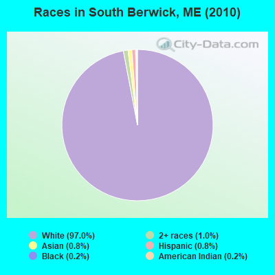
Races in South Berwick detailed stats: ancestries, foreign born residents, place of birth
According to our research of Maine and other state lists, there were 2 registered sex offenders living in South Berwick, Maine as of May 04, 2024.
The ratio of all residents to sex offenders in South Berwick is 3,610 to 1.
The ratio of registered sex offenders to all residents in this city is much lower than the state average.
Type |
2009 |
2010 |
2011 |
2012 |
2013 |
2014 |
2015 |
2016 |
2017 |
2018 |
2019 |
2020 |
2021 |
2022 |
|---|---|---|---|---|---|---|---|---|---|---|---|---|---|---|
| Murders (per 100,000) | 0 (0.0) | 0 (0.0) | 0 (0.0) | 0 (0.0) | 0 (0.0) | 0 (0.0) | 0 (0.0) | 0 (0.0) | 0 (0.0) | 0 (0.0) | 0 (0.0) | 0 (0.0) | 0 (0.0) | 0 (0.0) |
| Rapes (per 100,000) | 0 (0.0) | 1 (13.9) | 0 (0.0) | 3 (41.3) | 4 (55.0) | 4 (54.8) | 1 (13.6) | 4 (53.7) | 1 (13.4) | 5 (66.7) | 2 (26.4) | 0 (0.0) | 3 (39.2) | 4 (52.3) |
| Robberies (per 100,000) | 0 (0.0) | 0 (0.0) | 0 (0.0) | 0 (0.0) | 0 (0.0) | 0 (0.0) | 1 (13.6) | 1 (13.4) | 0 (0.0) | 0 (0.0) | 0 (0.0) | 2 (26.3) | 1 (13.1) | 0 (0.0) |
| Assaults (per 100,000) | 0 (0.0) | 0 (0.0) | 0 (0.0) | 2 (27.5) | 0 (0.0) | 5 (68.4) | 10 (136.2) | 4 (53.7) | 2 (26.8) | 2 (26.7) | 2 (26.4) | 2 (26.3) | 2 (26.1) | 1 (13.1) |
| Burglaries (per 100,000) | 15 (208.2) | 13 (180.1) | 18 (249.3) | 17 (234.0) | 12 (164.9) | 16 (219.0) | 12 (163.5) | 15 (201.2) | 8 (107.1) | 2 (26.7) | 11 (145.4) | 4 (52.6) | 6 (78.4) | 3 (39.2) |
| Thefts (per 100,000) | 50 (694.0) | 57 (789.5) | 48 (664.9) | 39 (536.8) | 57 (783.5) | 48 (657.1) | 31 (422.3) | 34 (456.1) | 21 (281.2) | 24 (320.0) | 23 (304.1) | 36 (473.4) | 29 (378.9) | 21 (274.4) |
| Auto thefts (per 100,000) | 2 (27.8) | 0 (0.0) | 1 (13.9) | 1 (13.8) | 3 (41.2) | 0 (0.0) | 1 (13.6) | 1 (13.4) | 1 (13.4) | 1 (13.3) | 3 (39.7) | 3 (39.4) | 2 (26.1) | 1 (13.1) |
| Arson (per 100,000) | 0 (0.0) | 5 (69.3) | 3 (41.6) | 0 (0.0) | 0 (0.0) | 0 (0.0) | 0 (0.0) | 0 (0.0) | 3 (40.2) | 1 (13.3) | 0 (0.0) | 0 (0.0) | 0 (0.0) | 2 (26.1) |
| City-Data.com crime index | 44.6 | 55.3 | 45.2 | 77.5 | 90.2 | 99.1 | 71.7 | 91.1 | 35.9 | 74.4 | 52.0 | 38.9 | 63.2 | 59.2 |
The City-Data.com crime index weighs serious crimes and violent crimes more heavily. Higher means more crime, U.S. average is 246.1. It adjusts for the number of visitors and daily workers commuting into cities.
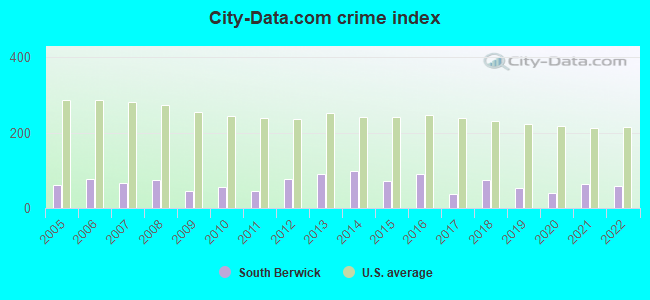
Crime rate in South Berwick detailed stats: murders, rapes, robberies, assaults, burglaries, thefts, arson
Full-time law enforcement employees in 2021, including police officers: 11 (10 officers - 10 male; 0 female).
| Officers per 1,000 residents here: | 1.31 |
| Maine average: | 1.71 |
 Recent articles from our blog. Our writers, many of them Ph.D. graduates or candidates, create easy-to-read articles on a wide variety of topics.

 | What makes South Berwick so wonderful? (0 replies) |
| Best cities to live in ME? (14 replies) |
| New parents starting to look at options.... South Berwick? (7 replies) |
| Building on "Somewhat poorly drained soil" based on survey??? (5 replies) |
| Why is crime so high in Biddeford? (41 replies) |
| The Age-Old "Kittery Vs. Portsmouth" Debate (9 replies) |
Latest news from South Berwick, ME collected exclusively by city-data.com from local newspapers, TV, and radio stations
South Berwick, ME City Guides:
Ancestries: English (23.8%), Irish (19.5%), French (11.3%), German (10.5%), French Canadian (10.4%), Scottish (5.0%).
Current Local Time: EST time zone
Incorporated on 02/12/1814
Elevation: 102 feet
Land area: 32.1 square miles.
Population density: 225 people per square mile (very low).
135 residents are foreign born (1.4% Europe, 0.6% North America).
| This town: | 2.0% |
| Maine: | 2.9% |
| South Berwick town: | 1.4% ($1,883) |
| Maine: | 1.5% ($1,417) |
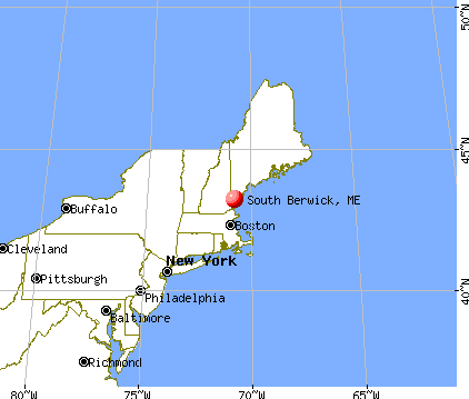
Nearest city with pop. 50,000+: Haverhill, MA  (35.2 miles , pop. 58,969).
Nearest city with pop. 200,000+: Boston, MA (65.1 miles , pop. 589,141).
Nearest city with pop. 1,000,000+: Bronx, NY (229.2 miles , pop. 1,332,650).
Nearest cities:
), ), ), )Latitude: 43.23 N, Longitude: 70.78 W
Area code: 207

Single-family new house construction building permits:
- 2022: 29 buildings, average cost: $361,700
- 2021: 31 buildings, average cost: $323,900
- 2020: 30 buildings, average cost: $248,900
- 2019: 22 buildings, average cost: $241,100
- 2018: 25 buildings, average cost: $217,400
- 2017: 26 buildings, average cost: $218,100
- 2016: 18 buildings, average cost: $215,300
- 2015: 10 buildings, average cost: $210,500
- 2014: 13 buildings, average cost: $200,300
- 2013: 12 buildings, average cost: $206,300
- 2012: 13 buildings, average cost: $137,800
- 2011: 3 buildings, average cost: $225,000
- 2010: 14 buildings, average cost: $165,700
- 2009: 12 buildings, average cost: $202,100
- 2008: 6 buildings, average cost: $250,800
- 2007: 14 buildings, average cost: $212,500
- 2006: 26 buildings, average cost: $213,800
- 2005: 28 buildings, average cost: $230,500
- 2004: 48 buildings, average cost: $157,500
- 2003: 35 buildings, average cost: $192,300
- 2002: 45 buildings, average cost: $146,500
- 2001: 35 buildings, average cost: $147,300
- 2000: 52 buildings, average cost: $138,800
- 1999: 39 buildings, average cost: $121,400
- 1998: 48 buildings, average cost: $117,800
- 1997: 39 buildings, average cost: $111,900
| Here: | 2.6% |
| Maine: | 3.4% |
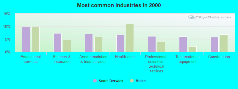
- Educational services (9.9%)
- Finance & insurance (7.3%)
- Accommodation & food services (7.1%)
- Health care (6.6%)
- Professional, scientific, technical services (6.2%)
- Transportation equipment (6.1%)
- Construction (5.8%)
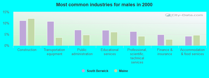
- Construction (11.2%)
- Transportation equipment (10.8%)
- Public administration (7.0%)
- Educational services (6.9%)
- Professional, scientific, technical services (6.3%)
- Finance & insurance (4.8%)
- Accommodation & food services (4.1%)
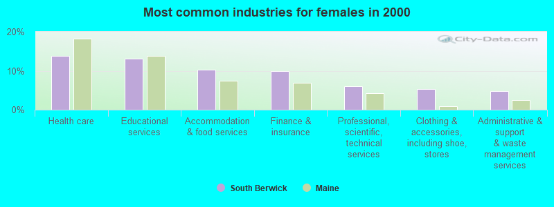
- Health care (13.8%)
- Educational services (13.1%)
- Accommodation & food services (10.3%)
- Finance & insurance (9.9%)
- Professional, scientific, technical services (6.1%)
- Clothing & accessories, including shoe, stores (5.3%)
- Administrative & support & waste management services (4.8%)
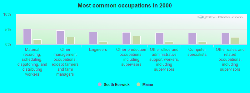
- Material recording, scheduling, dispatching, and distributing workers (5.1%)
- Other management occupations, except farmers and farm managers (4.6%)
- Engineers (4.1%)
- Other production occupations, including supervisors (4.1%)
- Other office and administrative support workers, including supervisors (3.9%)
- Computer specialists (3.8%)
- Other sales and related occupations, including supervisors (3.8%)
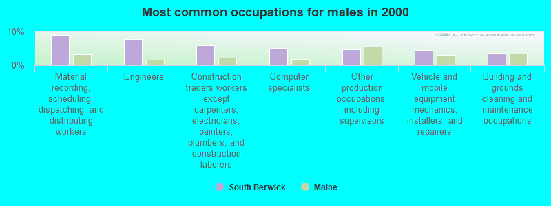
- Material recording, scheduling, dispatching, and distributing workers (9.0%)
- Engineers (7.8%)
- Construction traders workers except carpenters, electricians, painters, plumbers, and construction laborers (5.9%)
- Computer specialists (5.2%)
- Other production occupations, including supervisors (4.6%)
- Vehicle and mobile equipment mechanics, installers, and repairers (4.4%)
- Building and grounds cleaning and maintenance occupations (3.7%)

- Retail sales workers, except cashiers (7.0%)
- Secretaries and administrative assistants (6.7%)
- Other office and administrative support workers, including supervisors (6.4%)
- Other management occupations, except farmers and farm managers (6.0%)
- Registered nurses (5.8%)
- Other sales and related occupations, including supervisors (5.8%)
- Preschool, kindergarten, elementary, and middle school teachers (4.5%)
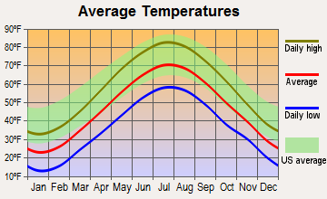
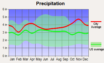
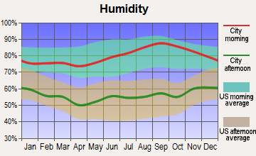
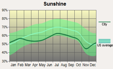
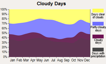
Average climate in South Berwick, Maine
Based on data reported by over 4,000 weather stations


(lower is better)
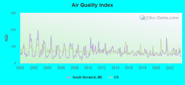
Air Quality Index (AQI) level in 2023 was 54.6. This is better than average.
| City: | 54.6 |
| U.S.: | 72.6 |
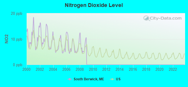
Nitrogen Dioxide (NO2) [ppb] level in 2008 was 7.38. This is significantly worse than average. Closest monitor was 5.6 miles away from the city center.
| City: | 7.38 |
| U.S.: | 5.11 |
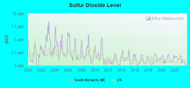
Sulfur Dioxide (SO2) [ppb] level in 2022 was 1.48. This is about average. Closest monitor was 5.6 miles away from the city center.
| City: | 1.48 |
| U.S.: | 1.51 |
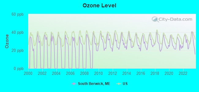
Ozone [ppb] level in 2023 was 30.2. This is about average. Closest monitor was 8.3 miles away from the city center.
| City: | 30.2 |
| U.S.: | 33.3 |
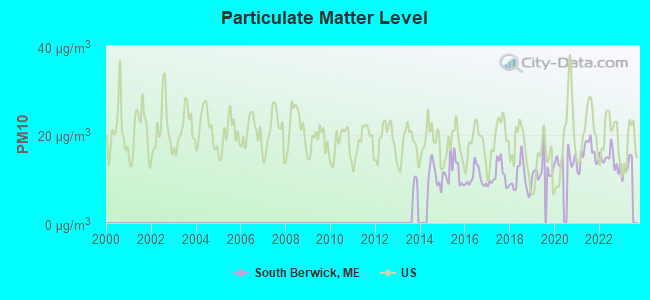
Particulate Matter (PM10) [µg/m3] level in 2022 was 14.4. This is better than average. Closest monitor was 5.6 miles away from the city center.
| City: | 14.4 |
| U.S.: | 19.2 |
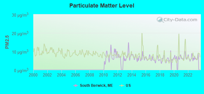
Particulate Matter (PM2.5) [µg/m3] level in 2022 was 6.41. This is better than average. Closest monitor was 10.9 miles away from the city center.
| City: | 6.41 |
| U.S.: | 8.11 |
Tornado activity:
South Berwick-area historical tornado activity is significantly above Maine state average. It is 60% smaller than the overall U.S. average.
On 6/9/1953, a category F3 (max. wind speeds 158-206 mph) tornado 20.7 miles away from the South Berwick town center injured 5 people and caused between $5000 and $50,000 in damages.
On 5/14/1963, a category F2 (max. wind speeds 113-157 mph) tornado 3.5 miles away from the town center caused between $5000 and $50,000 in damages.
Earthquake activity:
South Berwick-area historical earthquake activity is significantly above Maine state average. It is 73% smaller than the overall U.S. average.On 10/16/2012 at 23:12:25, a magnitude 4.7 (4.7 ML, Depth: 10.0 mi, Class: Light, Intensity: IV - V) earthquake occurred 25.8 miles away from South Berwick center
On 4/20/2002 at 10:50:47, a magnitude 5.3 (5.3 ML, Depth: 3.0 mi, Class: Moderate, Intensity: VI - VII) earthquake occurred 170.2 miles away from South Berwick center
On 1/19/1982 at 00:14:42, a magnitude 4.7 (4.5 MB, 4.7 MD, 4.5 LG) earthquake occurred 45.2 miles away from South Berwick center
On 10/7/1983 at 10:18:46, a magnitude 5.3 (5.1 MB, 5.3 LG, 5.1 ML) earthquake occurred 185.3 miles away from South Berwick center
On 4/20/2002 at 10:50:47, a magnitude 5.2 (5.2 MB, 4.2 MS, 5.2 MW, 5.0 MW) earthquake occurred 170.2 miles away from the city center
On 8/21/1996 at 07:54:14, a magnitude 3.8 (3.8 LG, 3.6 LG, Depth: 6.2 mi, Class: Light, Intensity: II - III) earthquake occurred 71.6 miles away from the city center
Magnitude types: regional Lg-wave magnitude (LG), body-wave magnitude (MB), duration magnitude (MD), local magnitude (ML), surface-wave magnitude (MS), moment magnitude (MW)
Natural disasters:
The number of natural disasters in York County (31) is a lot greater than the US average (15).Major Disasters (Presidential) Declared: 23
Emergencies Declared: 8
Causes of natural disasters: Floods: 21, Storms: 16, Winter Storms: 6, Snows: 5, Winds: 3, Heavy Rains: 2, Hurricanes: 2, Blizzard: 1, Ice Storm: 1, Mudslide: 1, Snowfall: 1, Snowstorm: 1, Tornado: 1, Tropical Storm: 1 (Note: some incidents may be assigned to more than one category).
Hospitals and medical centers near South Berwick:
- TRI-AREA VNA - HOSPICE (Hospital, about 5 miles away; SOMERSWORTH, NH)
- VARNEY CROSSING NCC (Nursing Home, about 6 miles away; NORTH BERWICK, ME)
- WENTWORTH-DOUGLASS HOSPITAL Acute Care Hospitals (about 6 miles away; DOVER, NH)
- LANGDON PLACE OF DOVER (Nursing Home, about 6 miles away; DOVER, NH)
- KINDRED TRANSITIONAL CARE AND REHABILITATION-DOVER (Nursing Home, about 6 miles away; DOVER, NH)
- WENTWORTH HOME CARE AND HOSPICE, AN AMEDISYS PARTNER (Home Health Center, about 6 miles away; DOVER, NH)
- SAINT ANN REHABILITATION AND NURSING CENTER (Nursing Home, about 7 miles away; DOVER, NH)
Colleges/universities with over 2000 students nearest to South Berwick:
- University of New Hampshire-Main Campus (about 11 miles; Durham, NH; Full-time enrollment: 15,243)
- University of New England (about 26 miles; Biddeford, ME; FT enrollment: 4,539)
- Northern Essex Community College (about 34 miles; Haverhill, MA; FT enrollment: 4,737)
- Southern New Hampshire University (about 37 miles; Manchester, NH; FT enrollment: 16,552)
- NHTI-Concord's Community College (about 38 miles; Concord, NH; FT enrollment: 2,865)
- University of Southern Maine (about 39 miles; Portland, ME; FT enrollment: 6,647)
- Mount Washington College (about 40 miles; Manchester, NH; FT enrollment: 2,187)
Public high school in South Berwick:
- MARSHWOOD HIGH SCHOOL (Location: 260 ROUTE 236, Grades: 9-12)
Private high school in South Berwick:
Public elementary/middle schools in South Berwick:
- CENTRAL SCHOOL (Students: 479, Location: 197 MAIN STREET, Grades: PK-3)
- MARSHWOOD GREAT WORKS SCHOOL (Location: 49 ACADEMY STREET, Grades: 4-5)
Points of interest:
Notable locations in South Berwick: South Berwick Emergency Ambulance and Rescue Service (A), Zebelon Knight Hall (B), South Berwick Fire Department (C), Sarah Orne Jewett Memorial (D), Hamilton House (E). Display/hide their locations on the map
Churches in South Berwick include: South Berwick Bible Speaks Church (A), South Berwick-Wells Church (B), Free Baptist Church (C). Display/hide their locations on the map
Cemeteries: Portland Station Cemetery (1), Pleasant Hill Cemetery (2), Oldfields Cemetery (3), Woodlawn Cemetery (4). Display/hide their locations on the map
Lakes, reservoirs, and swamps: Warren Pond (A), Cox Pond (B), Knights Pond (C), Round Pond (D), Great Works River Reservoir (E), Leighs Mill Pond (F), Hoopers Swamp (G). Display/hide their locations on the map
Streams, rivers, and creeks: Adams Brook (A), Whites Marsh Brook (B), Hoopers Brook (C), Shoreys Brook (D), Warren Brook (E), Hilton Brook (F), Hamilton Brook (G), Quamphegan Brook (H), Knights Brook (I). Display/hide their locations on the map
Parks in South Berwick include: Vaughan Woods State Park (1), Spring Hill Recreation Area (2), Orris Falls Conservation Area (3). Display/hide their locations on the map
Tourist attractions: Hamilton House The (Museums; Vaughans Ln) (1), Jewett House (Cultural Attractions- Events- & Facilities; 5 Portland Street) (2). Display/hide their approximate locations on the map
Birthplace of: Sarah Orne Jewett - Novelist, Charles Herbert Woodbury - Painter, John H. Burleigh - Politician.
Drinking water stations with addresses in South Berwick and their reported violations in the past:
SOUTH BERWICK WATER DISTRICT (Population served: 3,530, Groundwater):Past monitoring violations:SPRING HILL INC (Population served: 300, Groundwater):
- 2 regular monitoring violations
Past monitoring violations:WOODLAND HILLS CONDO ASSOC (Population served: 253, Groundwater):
- 8 routine major monitoring violations
- One regular monitoring violation
Past monitoring violations:LITTLE BUDDIES CHILDCARE LLC (Population served: 27, Groundwater):
- Follow-up Or Routine LCR Tap M/R - In JUL-01-2011, Contaminant: Lead and Copper Rule. Follow-up actions: St Compliance achieved (JUL-22-2011), St Public Notif requested (SEP-06-2011), St Formal NOV issued (SEP-06-2011), St Public Notif received (SEP-29-2011)
- Follow-up Or Routine LCR Tap M/R - In OCT-01-2008, Contaminant: Lead and Copper Rule. Follow-up actions: St Public Notif requested (FEB-13-2009), St Formal NOV issued (FEB-13-2009), St Public Notif received (MAR-10-2009), St Compliance achieved (AUG-29-2011)
- Follow-up Or Routine LCR Tap M/R - In JAN-11-2005, Contaminant: Lead and Copper Rule. Follow-up actions: St Public Notif requested (FEB-11-2005), St Violation/Reminder Notice (FEB-11-2005), St Compliance achieved (JUL-21-2005), St Public Notif received (JUL-21-2005)
- Follow-up Or Routine LCR Tap M/R - In JAN-11-2003, Contaminant: Lead and Copper Rule. Follow-up actions: St Public Notif requested (FEB-11-2005), St Violation/Reminder Notice (FEB-11-2005), St Compliance achieved (JUL-21-2005), St Public Notif received (JUL-21-2005)
- Follow-up Or Routine LCR Tap M/R - In JAN-11-2002, Contaminant: Lead and Copper Rule. Follow-up actions: St Public Notif requested (FEB-11-2005), St Violation/Reminder Notice (FEB-11-2005), St Compliance achieved (JUL-21-2005), St Public Notif received (JUL-21-2005)
Past monitoring violations:
- 2 routine major monitoring violations
- 2 regular monitoring violations
| This town: | 2.6 people |
| Maine: | 2.3 people |
| This town: | 72.5% |
| Whole state: | 62.9% |
| This town: | 6.8% |
| Whole state: | 9.4% |
Likely homosexual households (counted as self-reported same-sex unmarried-partner households)
- Lesbian couples: 0.5% of all households
- Gay men: 0.3% of all households
| This town: | 2.9% |
| Whole state: | 10.9% |
| This town: | 0.1% |
| Whole state: | 4.1% |
36 people in other noninstitutional group quarters in 2000
Banks with branches in South Berwick (2011 data):
- People's United Bank: South Berwick Branch at 8 Norton Street, branch established on 1996/11/04. Info updated 2012/02/16: Bank assets: $27,319.3 mil, Deposits: $20,835.4 mil, headquarters in Bridgeport, CT, positive income, Commercial Lending Specialization, 374 total offices
For population 15 years and over in South Berwick:
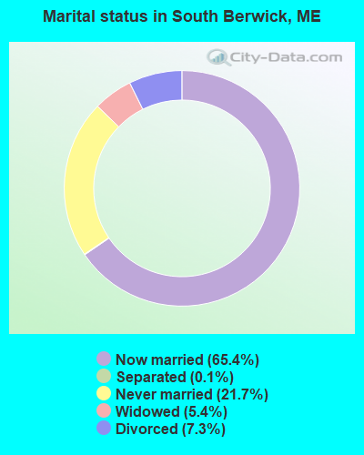
- Never married: 21.7%
- Now married: 65.4%
- Separated: 0.1%
- Widowed: 5.4%
- Divorced: 7.3%
For population 25 years and over in South Berwick:
- High school or higher: 91.4%
- Bachelor's degree or higher: 25.3%
- Graduate or professional degree: 7.4%
- Unemployed: 2.3%
- Mean travel time to work (commute): 26.8 minutes
| Here: | 9.6 |
| Maine average: | 11.2 |


Graphs represent county-level data. Detailed 2008 Election Results
Religion statistics for South Berwick, ME (based on York County data)


| Religion | Adherents | Congregations |
|---|---|---|
| Catholic | 40,283 | 16 |
| Mainline Protestant | 11,480 | 64 |
| Evangelical Protestant | 6,086 | 51 |
| Other | 1,847 | 18 |
| Orthodox | 625 | 3 |
| Black Protestant | 119 | 1 |
| None | 136,691 | - |
Food Environment Statistics:
| York County: | 2.24 / 10,000 pop. |
| Maine: | 2.80 / 10,000 pop. |
| York County: | 0.05 / 10,000 pop. |
| Maine: | 0.14 / 10,000 pop. |
| York County: | 2.09 / 10,000 pop. |
| Maine: | 2.20 / 10,000 pop. |
| Here: | 4.23 / 10,000 pop. |
| Maine: | 5.75 / 10,000 pop. |
| Here: | 12.53 / 10,000 pop. |
| Maine: | 11.02 / 10,000 pop. |
| Here: | 7.7% |
| Maine: | 8.2% |
| This county: | 24.0% |
| State: | 25.0% |
Businesses in South Berwick, ME
- Curves: 1
- Dunkin Donuts: 1
Strongest AM radio stations in South Berwick:
- WTSN (1270 AM; 5 kW; DOVER, NH; Owner: GARRISON CITY BROADCASTING, INC.)
- WGIN (930 AM; 10 kW; ROCHESTER, NH; Owner: CAPSTAR TX LIMITED PARTNERSHIP)
- WRKO (680 AM; 50 kW; BOSTON, MA; Owner: ENTERCOM BOSTON LICENSE, LLC)
- WEEI (850 AM; 50 kW; BOSTON, MA; Owner: ENTERCOM BOSTON LICENSE, LLC)
- WBZ (1030 AM; 50 kW; BOSTON, MA; Owner: INFINITY BROADCASTING OPERATIONS, INC.)
- WMTW (870 AM; 10 kW; GORHAM, ME; Owner: RADIO PARTNERS OF MAINE, L.P.)
- WGIP (1540 AM; 5 kW; EXETER, NH; Owner: CAPSTAR TX LIMITED PARTNERSHIP)
- WWZN (1510 AM; 50 kW; BOSTON, MA; Owner: ROSE CITY RADIO CORPORATION)
- WKOX (1200 AM; 50 kW; FRAMINGHAM, MA; Owner: CAPSTAR TX LIMITED PARTNERSHIP)
- WCRN (830 AM; 50 kW; WORCESTER, MA; Owner: CARTER BROADCASTING CORPORATION)
- WBIX (1060 AM; 40 kW; NATICK, MA; Owner: LANGER BROADCASTING CORPORATION)
- WDER (1320 AM; 10 kW; DERRY, NH; Owner: BLOUNT COMMUNICATIONS, INC. OF NH)
- WGAN (560 AM; 5 kW; PORTLAND, ME; Owner: SAGA COMMUNICATIONS OF NEW ENGLAND, LLC)
Strongest FM radio stations in South Berwick:
- WUBB (95.3 FM; YORK CENTER, ME; Owner: CAPSTAR TX LIMITED PARTNERSHIP)
- WSHK (105.3 FM; KITTERY, ME; Owner: CITADEL BROADCASTING COMPANY)
- WBYY (98.7 FM; SOMERSWORTH, NH; Owner: GARRISON CITY BROADCASTING, INC.)
- WOKQ (97.5 FM; DOVER, NH; Owner: CITADEL BROADCASTING COMPANY)
- WPHX-FM (92.1 FM; SANFORD, ME; Owner: FNX BROADCASTING LLC)
- WSEW (88.5 FM; SANFORD, ME; Owner: WORD RADIO EDUCATIONAL FOUNDATION)
- WQSO (96.7 FM; ROCHESTER, NH; Owner: CAPSTAR TX LIMITED PARTNERSHIP)
- WHEB (100.3 FM; PORTSMOUTH, NH; Owner: CAPSTAR TX LIMITED PARTNERSHIP)
- WSCY (106.9 FM; MOULTONBOROUGH, NH; Owner: NORTHEAST COMMUNICATIONS CORPORATION)
- WMEA (90.1 FM; PORTLAND, ME; Owner: MAINE PUBLIC BROADCASTING CORPORATION)
- WUNH (91.3 FM; DURHAM, NH; Owner: UNIVERSITY OF NEW HAMPSHIRE)
- WPKQ (103.7 FM; NORTH CONWAY, NH; Owner: CITADEL BROADCASTING COMPANY)
- WHOM (94.9 FM; MT. WASHINGTON, NH; Owner: CITADEL BROADCASTING COMPANY)
- WMEX (106.5 FM; FARMINGTON, NH; Owner: WIMMEX, LLC)
- WERZ (107.1 FM; EXETER, NH; Owner: CAPSTAR TX LIMITED PARTNERSHIP)
- WLKZ (104.9 FM; WOLFEBORO, NH; Owner: TELE-MEDIA COMPANY OF NEW HAMPSHIRE, L.L.C.)
- WBLM (102.9 FM; PORTLAND, ME; Owner: CITADEL BROADCASTING COMPANY)
- WNHI (93.3 FM; BELMONT, NH; Owner: CONCORD BROADCASTING, L.L.C.)
- WGIR-FM (101.1 FM; MANCHESTER, NH; Owner: CAPSTAR TX LIMITED PARTNERSHIP)
- WQEZ (104.7 FM; KENNEBUNKPORT, ME; Owner: MARINER BROADCASTING L.P.)
TV broadcast stations around South Berwick:
- WMEA-TV (Channel 26; BIDDEFORD, ME; Owner: MAINE PUBLIC BROADCASTING CORP.)
- WHDN-LP (Channel 26; BOSTON, MA; Owner: GUENTER MARKSTEINER)
- WMTW-TV (Channel 8; POLAND SPRING, ME; Owner: WMTW BROADCAST GROUP, LLC)
- WENH-TV (Channel 11; DURHAM, NH; Owner: UNIVERSITY OF NEW HAMPSHIRE)
- WCSH (Channel 6; PORTLAND, ME; Owner: PACIFIC AND SOUTHERN COMPANY, INC.)
- WGME-TV (Channel 13; PORTLAND, ME; Owner: WGME LICENSEE, LLC)
- WFXZ-CA (Channel 24; BOSTON, MA; Owner: BOSTON BROADCASTING CORP.)
- National Bridge Inventory (NBI) Statistics
- 10Number of bridges
- 138ft / 42.0mTotal length
- 37,384Total average daily traffic
- 1,866Total average daily truck traffic
- 52,935Total future (year 2036) average daily traffic
- New bridges - historical statistics
- 1Before 1900
- 11950-1959
- 21960-1969
- 11970-1979
- 11980-1989
- 22000-2009
- 22010-2019
FCC Registered Antenna Towers:
8 (See the full list of FCC Registered Antenna Towers in South Berwick)FCC Registered Broadcast Land Mobile Towers:
4- Fire Station Norton St (Lat: 43.236194 Lon: -70.832833), Call Sign: KCC327,
Assigned Frequencies: 154.190 MHz, 154.310 MHz, Grant Date: 10/19/2015, Expiration Date: 12/17/2025, Registrant: 2-Way Communications Service Inc, 19 Durham Street, Portsmouth, NH 03801-2872, Phone: (603) 431-6288, Email:
- 170 Main St (Lat: 43.233972 Lon: -70.809778), Call Sign: KNCX797, Licensee ID: L00081732,
Assigned Frequencies: 158.460 MHz, Grant Date: 01/23/2002, Expiration Date: 02/13/2012, Cancellation Date: 04/14/2012, Registrant: Save On Fuel Inc, 11 Pond Rd, South Berwick, ME 03908, Phone: (207) 384-2942
- Reservoir On Wadleigh Lane (Lat: 43.233861 Lon: -70.785333), Type: Pole, Structure height: 15.2 m, Overall height: 18.2 m, Call Sign: WPVY824,
Assigned Frequencies: 458.400 MHz, Grant Date: 09/23/2022, Expiration Date: 09/09/2032, Certifier: Michael R Nadeau, Registrant: Tcs Communications Corp, Salibury, MA 01952, Phone: (978) 465-7932, Fax: (978) 462-8980, Email:
- Wadleigh Ln (Lat: 43.233917 Lon: -70.802056), Type: Tower, Structure height: 30.5 m, Overall height: 36.6 m, Call Sign: WQFI859,
Assigned Frequencies: 155.835 MHz, Grant Date: 06/09/2016, Expiration Date: 07/26/2026, Certifier: Lajoie P Dana, Registrant: 2-Way Communications Service, Inc., 23 River Road, Newington, NH 03801-2832, Phone: (603) 431-6288, Fax: (603) 431-4832, Email:
FCC Registered Microwave Towers:
1- Various Locations (Lat: 43.234528 Lon: -70.809500), Overall height: 6.1 m, Call Sign: WNTW549,
Assigned Frequencies: 956.368 MHz, Grant Date: 02/19/2020, Expiration Date: 11/03/2029, Registrant: South Berwick Water District, 80 Berwick Road, South Berwick, ME 03908, Phone: (207) 384-2257
FCC Registered Amateur Radio Licenses:
39 (See the full list of FCC Registered Amateur Radio Licenses in South Berwick)FAA Registered Aircraft:
2- Aircraft: FLOATPLANES & AMPHIBS LLC A-22 VALOR (Category: Land, Seats: 2, Weight: Up to 12,499 Pounds), Engine: ROTAX 912ULS SERIES (100 HP) (4 Cycle)
N-Number: 707FP, N707FP, N-707FP, Serial Number: 181, Year manufactured: 2007, Airworthiness Date: 07/02/2007, Certificate Issue Date: 04/01/2019
Registrant (Individual): Brian M Vansickle, 86 Oldfields Rd, South Berwick, ME 03908 - Aircraft: CESSNA 182P (Category: Land, Seats: 4, Weight: Up to 12,499 Pounds, Speed: 120 mph), Engine: CONT MOTOR O-470 SERIES (230 HP) (Reciprocating)
N-Number: 7313S, N7313S, N-7313S, Serial Number: 18265105, Year manufactured: 1976, Airworthiness Date: 10/01/1976, Certificate Issue Date: 07/08/2005
Registrant (Individual): Matthew H Rogers, 87 Belle Marsh Rd, South Berwick, ME 03908
2004 - 2018 National Fire Incident Reporting System (NFIRS) incidents
- Fire incident types reported to NFIRS in South Berwick, ME
- 22265.1%Structure Fires
- 7120.8%Outside Fires
- 277.9%Mobile Property/Vehicle Fires
- 216.2%Other
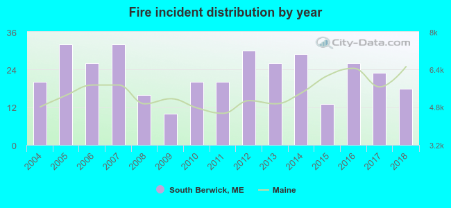 According to the data from the years 2004 - 2018 the average number of fires per year is 23. The highest number of fires - 32 took place in 2005, and the least - 10 in 2009. The data has a dropping trend.
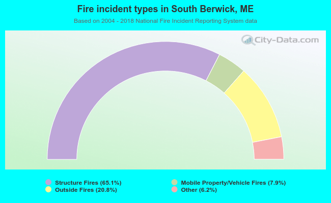 When looking into fire subcategories, the most incidents belonged to: Structure Fires (65.1%), and Outside Fires (20.8%).
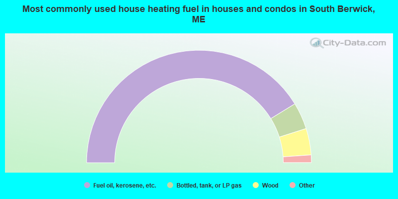
- 82.5%Fuel oil, kerosene, etc.
- 7.7%Bottled, tank, or LP gas
- 7.6%Wood
- 1.2%Electricity
- 1.0%Other fuel
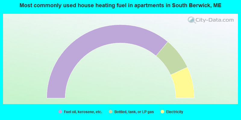
- 72.1%Fuel oil, kerosene, etc.
- 14.0%Bottled, tank, or LP gas
- 13.8%Electricity
South Berwick compared to Maine state average:
- Unemployed percentage significantly below state average.
- Black race population percentage significantly below state average.
- Hispanic race population percentage below state average.
- Foreign-born population percentage below state average.
- Length of stay since moving in significantly above state average.
- Number of rooms per house significantly below state average.
- House age significantly below state average.
South Berwick on our top lists:
- #2 on the list of "Top 101 cities with largest percentage of males in occupations: material recording, scheduling, dispatching, and distributing workers (population 5,000+)"
- #5 on the list of "Top 101 cities with largest percentage of females in industries: sporting goods, camera, and hobby and toy stores (population 5,000+)"
- #6 on the list of "Top 101 cities with largest percentage of females in industries: clothing and accessories, including shoe, stores (population 5,000+)"
- #14 on the list of "Top 101 cities with largest percentage of females in occupations: drafters, engineering, and mapping technicians (population 5,000+)"
- #19 on the list of "Top 101 cities with largest percentage of males in industries: health and personal care, except drug, stores (population 5,000+)"
- #22 on the list of "Top 101 cities with largest percentage of females in occupations: retail sales workers except cashiers (population 5,000+)"
- #32 on the list of "Top 101 cities with largest percentage of males in occupations: engineers (population 5,000+)"
- #36 on the list of "Top 101 cities with largest percentage of females in industries: professional and commercial equipment and supplies merchant wholesalers (population 5,000+)"
- #37 on the list of "Top 101 cities with largest percentage of males in industries: transportation equipment (population 5,000+)"
- #41 on the list of "Top 101 cities with largest percentage of males in occupations: social scientists and related workers (population 5,000+)"
- #44 on the list of "Top 101 cities with largest percentage of males in industries: data processing, libraries, and other information services (population 5,000+)"
- #45 on the list of "Top 101 cities with largest percentage of females in industries: miscellaneous nondurable goods merchant wholesalers (population 5,000+)"
- #54 on the list of "Top 101 cities with largest percentage of males in occupations: financial clerks except bookkeeping, accounting, and auditing clerks (population 5,000+)"
- #57 on the list of "Top 101 cities with the largest city-data.com crime index increase from 2011 to 2012 (population 5,000+)"
- #63 on the list of "Top 101 cities with largest percentage of males in industries: sporting goods, camera, and hobby and toy stores (population 5,000+)"
- #65 on the list of "Top 101 cities with largest percentage of males in industries: building material and garden equipment and supplies dealers (population 5,000+)"
- #69 on the list of "Top 101 cities with largest percentage of males in industries: leather and allied products (population 5,000+)"
- #84 on the list of "Top 101 cities with largest percentage of males in industries: other transportation, and support activities, and couriers (population 5,000+)"
- #98 on the list of "Top 101 cities with largest percentage of males in industries: furniture and related product manufacturing (population 5,000+)"
- #21 on the list of "Top 101 counties with the highest percentage of residents that smoked 100+ cigarettes in their lives"
- #35 on the list of "Top 101 counties with the lowest number of births per 1000 residents 2007-2013"
- #70 on the list of "Top 101 counties with the highest percentage of residents that keep firearms around their homes"
- #77 on the list of "Top 101 counties with the best general health status score of residents (1-5), 3 years of data"

|
|
Total of 77 patent applications in 2008-2024.